 Note:
The expiration time in the watch graphic is amended if the watch is
replaced, cancelled or extended.
Note:
Note:
The expiration time in the watch graphic is amended if the watch is
replaced, cancelled or extended.
Note: Click for
Watch Status Reports.
SEL5
URGENT - IMMEDIATE BROADCAST REQUESTED
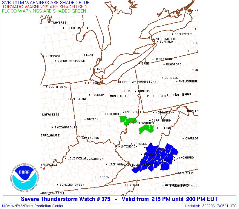
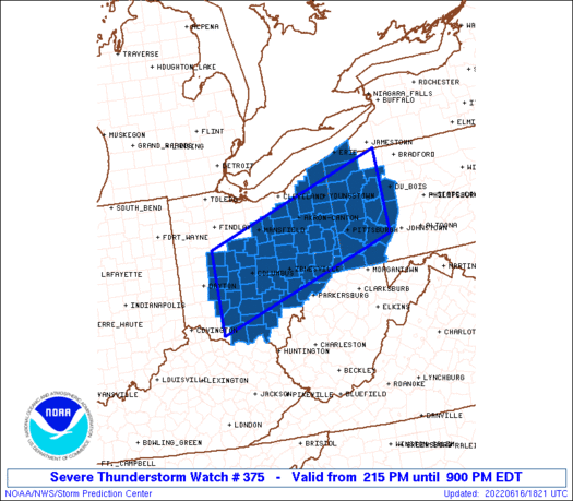
Severe Thunderstorm Watch Number 375
NWS Storm Prediction Center Norman OK
215 PM EDT Thu Jun 16 2022
The NWS Storm Prediction Center has issued a
* Severe Thunderstorm Watch for portions of
Ohio
Western Pennsylvania
Northern West Virginia
* Effective this Thursday afternoon and evening from 215 PM until
900 PM EDT.
* Primary threats include...
Scattered damaging wind gusts to 70 mph possible
Isolated large hail events to 1.5 inches in diameter possible
A tornado or two possible
SUMMARY...Scattered strong to severe thunderstorms are expected to
steadily develop across the region this afternoon, initially across
central/northeast Ohio into west/northwest Pennsylvania.
The severe thunderstorm watch area is approximately along and 60
statute miles north and south of a line from 40 miles east southeast
of Franklin PA to 55 miles west southwest of Columbus OH. For a
complete depiction of the watch see the associated watch outline
update (WOUS64 KWNS WOU5).
PRECAUTIONARY/PREPAREDNESS ACTIONS...
REMEMBER...A Severe Thunderstorm Watch means conditions are
favorable for severe thunderstorms in and close to the watch area.
Persons in these areas should be on the lookout for threatening
weather conditions and listen for later statements and possible
warnings. Severe thunderstorms can and occasionally do produce
tornadoes.
&&
AVIATION...A few severe thunderstorms with hail surface and aloft to
1.5 inches. Extreme turbulence and surface wind gusts to 60 knots. A
few cumulonimbi with maximum tops to 550. Mean storm motion vector
28030.
...Guyer
   SEL5

   URGENT - IMMEDIATE BROADCAST REQUESTED
   Severe Thunderstorm Watch Number 375
   NWS Storm Prediction Center Norman OK
   215 PM EDT Thu Jun 16 2022

   The NWS Storm Prediction Center has issued a

   * Severe Thunderstorm Watch for portions of
     Ohio
     Western Pennsylvania
     Northern West Virginia

   * Effective this Thursday afternoon and evening from 215 PM until
     900 PM EDT.

   * Primary threats include...
     Scattered damaging wind gusts to 70 mph possible
     Isolated large hail events to 1.5 inches in diameter possible
     A tornado or two possible

   SUMMARY...Scattered strong to severe thunderstorms are expected to
   steadily develop across the region this afternoon, initially across
   central/northeast Ohio into west/northwest Pennsylvania.

   The severe thunderstorm watch area is approximately along and 60
   statute miles north and south of a line from 40 miles east southeast
   of Franklin PA to 55 miles west southwest of Columbus OH. For a
   complete depiction of the watch see the associated watch outline
   update (WOUS64 KWNS WOU5).

   PRECAUTIONARY/PREPAREDNESS ACTIONS...

   REMEMBER...A Severe Thunderstorm Watch means conditions are
   favorable for severe thunderstorms in and close to the watch area.
   Persons in these areas should be on the lookout for threatening
   weather conditions and listen for later statements and possible
   warnings. Severe thunderstorms can and occasionally do produce
   tornadoes.

   &&

   AVIATION...A few severe thunderstorms with hail surface and aloft to
   1.5 inches. Extreme turbulence and surface wind gusts to 60 knots. A
   few cumulonimbi with maximum tops to 550. Mean storm motion vector
   28030.

   ...Guyer
 Note:
The Aviation Watch (SAW) product is an approximation to the watch area.
The actual watch is depicted by the shaded areas.
Note:
The Aviation Watch (SAW) product is an approximation to the watch area.
The actual watch is depicted by the shaded areas.
   SAW5
   WW 375 SEVERE TSTM OH PA WV 161815Z - 170100Z
   AXIS..60 STATUTE MILES NORTH AND SOUTH OF LINE..
   40ESE FKL/FRANKLIN PA/ - 55WSW CMH/COLUMBUS OH/
   ..AVIATION COORDS.. 50NM N/S /51ENE EWC - 37SSE ROD/
   HAIL SURFACE AND ALOFT..1.5 INCHES. WIND GUSTS..60 KNOTS.
   MAX TOPS TO 550. MEAN STORM MOTION VECTOR 28030.

   LAT...LON 40297916 38828384 40568384 42027916

   THIS IS AN APPROXIMATION TO THE WATCH AREA.  FOR A
   COMPLETE DEPICTION OF THE WATCH SEE WOUS64 KWNS
   FOR WOU5.
Watch 375 Status Report Messages:
STATUS REPORT #4 ON WW 375
VALID 162325Z - 170040Z
SEVERE WEATHER THREAT CONTINUES RIGHT OF A LINE FROM 10 S DAY TO
15 W CMH TO 25 ENE CMH TO 25 W HLG TO 20 S HLG TO 20 WNW MGW.
..WENDT..06/16/22
ATTN...WFO...ILN...CLE...RLX...PBZ...
&&
STATUS REPORT FOR WS 375
SEVERE WEATHER THREAT CONTINUES FOR THE FOLLOWING AREAS
OHC009-013-045-047-049-059-073-079-089-097-111-115-119-121-127-
129-141-163-167-170040-
OH
. OHIO COUNTIES INCLUDED ARE
ATHENS BELMONT FAIRFIELD
FAYETTE FRANKLIN GUERNSEY
HOCKING JACKSON LICKING
MADISON MONROE MORGAN
MUSKINGUM NOBLE PERRY
PICKAWAY ROSS VINTON
WASHINGTON
$$
WVC051-170040-
WV
. WEST VIRGINIA COUNTIES INCLUDED ARE
MARSHALL
$$
THE WATCH STATUS MESSAGE IS FOR GUIDANCE PURPOSES ONLY. PLEASE
REFER TO WATCH COUNTY NOTIFICATION STATEMENTS FOR OFFICIAL
INFORMATION ON COUNTIES...INDEPENDENT CITIES AND MARINE ZONES
CLEARED FROM SEVERE THUNDERSTORM AND TORNADO WATCHES.
$$
STATUS REPORT #3 ON WW 375
VALID 162235Z - 162340Z
SEVERE WEATHER THREAT CONTINUES RIGHT OF A LINE FROM 20 SE DAY TO
35 W CMH TO 15 NNW CMH TO 30 WNW HLG TO 15 NW HLG TO 15 E HLG TO
25 NNE MGW.
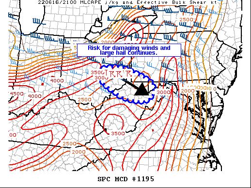
FOR ADDITIONAL INFORMATION SEE MESOSCALE DISCUSSION 1195
..WENDT..06/16/22
ATTN...WFO...ILN...CLE...RLX...PBZ...
&&
STATUS REPORT FOR WS 375
SEVERE WEATHER THREAT CONTINUES FOR THE FOLLOWING AREAS
OHC009-013-045-047-049-059-073-079-089-097-111-115-119-121-127-
129-141-163-167-162340-
OH
. OHIO COUNTIES INCLUDED ARE
ATHENS BELMONT FAIRFIELD
FAYETTE FRANKLIN GUERNSEY
HOCKING JACKSON LICKING
MADISON MONROE MORGAN
MUSKINGUM NOBLE PERRY
PICKAWAY ROSS VINTON
WASHINGTON
$$
PAC059-162340-
PA
. PENNSYLVANIA COUNTIES INCLUDED ARE
GREENE
$$
WVC051-069-162340-
WV
. WEST VIRGINIA COUNTIES INCLUDED ARE
MARSHALL OHIO
$$
THE WATCH STATUS MESSAGE IS FOR GUIDANCE PURPOSES ONLY. PLEASE
REFER TO WATCH COUNTY NOTIFICATION STATEMENTS FOR OFFICIAL
INFORMATION ON COUNTIES...INDEPENDENT CITIES AND MARINE ZONES
CLEARED FROM SEVERE THUNDERSTORM AND TORNADO WATCHES.
$$
STATUS REPORT #2 ON WW 375
VALID 162055Z - 162140Z
SEVERE WEATHER THREAT CONTINUES RIGHT OF A LINE FROM 35 NE DAY TO
20 S MFD TO 20 NNE CAK TO 25 ENE CLE.
..LYONS..06/16/22
ATTN...WFO...ILN...CLE...RLX...PBZ...
&&
STATUS REPORT FOR WS 375
SEVERE WEATHER THREAT CONTINUES FOR THE FOLLOWING AREAS
OHC001-007-009-013-019-021-023-027-029-031-041-045-047-049-055-
057-059-067-071-073-075-079-081-083-089-097-099-111-115-119-121-
127-129-131-141-145-151-155-157-163-167-162140-
OH
. OHIO COUNTIES INCLUDED ARE
ADAMS ASHTABULA ATHENS
BELMONT CARROLL CHAMPAIGN
CLARK CLINTON COLUMBIANA
COSHOCTON DELAWARE FAIRFIELD
FAYETTE FRANKLIN GEAUGA
GREENE GUERNSEY HARRISON
HIGHLAND HOCKING HOLMES
JACKSON JEFFERSON KNOX
LICKING MADISON MAHONING
MONROE MORGAN MUSKINGUM
NOBLE PERRY PICKAWAY
PIKE ROSS SCIOTO
STARK TRUMBULL TUSCARAWAS
VINTON WASHINGTON
$$
PAC003-005-007-019-031-039-049-051-053-059-063-065-073-085-121-
125-129-162140-
PA
. PENNSYLVANIA COUNTIES INCLUDED ARE
ALLEGHENY ARMSTRONG BEAVER
BUTLER CLARION CRAWFORD
ERIE FAYETTE FOREST
GREENE INDIANA JEFFERSON
LAWRENCE MERCER VENANGO
WASHINGTON WESTMORELAND
$$
WVC009-029-051-069-162140-
WV
. WEST VIRGINIA COUNTIES INCLUDED ARE
BROOKE HANCOCK MARSHALL
OHIO
$$
THE WATCH STATUS MESSAGE IS FOR GUIDANCE PURPOSES ONLY. PLEASE
REFER TO WATCH COUNTY NOTIFICATION STATEMENTS FOR OFFICIAL
INFORMATION ON COUNTIES...INDEPENDENT CITIES AND MARINE ZONES
CLEARED FROM SEVERE THUNDERSTORM AND TORNADO WATCHES.
$$
STATUS REPORT #1 ON WW 375
VALID 161950Z - 162040Z
THE SEVERE WEATHER THREAT CONTINUES ACROSS THE ENTIRE WATCH AREA.
FOR ADDITIONAL INFORMATION SEE MESOSCALE DISCUSSION 1191
..LYONS..06/16/22
ATTN...WFO...ILN...CLE...RLX...PBZ...
&&
STATUS REPORT FOR WS 375
SEVERE WEATHER THREAT CONTINUES FOR THE FOLLOWING AREAS
OHC001-005-007-009-013-019-021-023-027-029-031-041-045-047-049-
055-057-059-067-071-073-075-079-081-083-089-091-097-099-101-103-
111-115-117-119-121-127-129-131-133-139-141-145-151-153-155-157-
159-163-167-169-162040-
OH
. OHIO COUNTIES INCLUDED ARE
ADAMS ASHLAND ASHTABULA
ATHENS BELMONT CARROLL
CHAMPAIGN CLARK CLINTON
COLUMBIANA COSHOCTON DELAWARE
FAIRFIELD FAYETTE FRANKLIN
GEAUGA GREENE GUERNSEY
HARRISON HIGHLAND HOCKING
HOLMES JACKSON JEFFERSON
KNOX LICKING LOGAN
MADISON MAHONING MARION
MEDINA MONROE MORGAN
MORROW MUSKINGUM NOBLE
PERRY PICKAWAY PIKE
PORTAGE RICHLAND ROSS
SCIOTO STARK SUMMIT
TRUMBULL TUSCARAWAS UNION
VINTON WASHINGTON WAYNE
$$
PAC003-005-007-019-031-039-049-051-053-059-063-065-073-085-121-
125-129-162040-
PA
. PENNSYLVANIA COUNTIES INCLUDED ARE
ALLEGHENY ARMSTRONG BEAVER
BUTLER CLARION CRAWFORD
ERIE FAYETTE FOREST
GREENE INDIANA JEFFERSON
LAWRENCE MERCER VENANGO
WASHINGTON WESTMORELAND
$$
WVC009-029-051-069-162040-
WV
. WEST VIRGINIA COUNTIES INCLUDED ARE
BROOKE HANCOCK MARSHALL
OHIO
$$
THE WATCH STATUS MESSAGE IS FOR GUIDANCE PURPOSES ONLY. PLEASE
REFER TO WATCH COUNTY NOTIFICATION STATEMENTS FOR OFFICIAL
INFORMATION ON COUNTIES...INDEPENDENT CITIES AND MARINE ZONES
CLEARED FROM SEVERE THUNDERSTORM AND TORNADO WATCHES.
$$
Note:
Click for Complete Product Text.
Tornadoes
Probability of 2 or more tornadoes
|
Low (20%)
|
Probability of 1 or more strong (EF2-EF5) tornadoes
|
Low (10%)
|
Wind
Probability of 10 or more severe wind events
|
Mod (50%)
|
Probability of 1 or more wind events > 65 knots
|
Low (10%)
|
Hail
Probability of 10 or more severe hail events
|
Mod (30%)
|
Probability of 1 or more hailstones > 2 inches
|
Low (10%)
|
Combined Severe Hail/Wind
Probability of 6 or more combined severe hail/wind events
|
High (80%)
|
For each watch, probabilities for particular events inside the watch
(listed above in each table) are determined by the issuing forecaster.
The "Low" category contains probability values ranging from less than 2%
to 20% (EF2-EF5 tornadoes), less than 5% to 20% (all other probabilities),
"Moderate" from 30% to 60%, and "High" from 70% to greater than 95%.
High values are bolded and lighter in color to provide awareness of
an increased threat for a particular event.


 @NWSSPC