 Note:
The expiration time in the watch graphic is amended if the watch is
replaced, cancelled or extended.
Note:
Note:
The expiration time in the watch graphic is amended if the watch is
replaced, cancelled or extended.
Note: Click for
Watch Status Reports.
SEL6
URGENT - IMMEDIATE BROADCAST REQUESTED
Tornado Watch Number 6
NWS Storm Prediction Center Norman OK
255 AM CST Tue Jan 3 2023
The NWS Storm Prediction Center has issued a
* Tornado Watch for portions of
Southeastern Arkansas
Southwestern and central Kentucky
Northern Louisiana
Western and northern Mississippi
Western and middle Tennessee
Extreme east Texas
* Effective this Tuesday morning from 255 AM until 1100 AM CST.
* Primary threats include...
A few tornadoes possible
Isolated damaging wind gusts to 70 mph possible
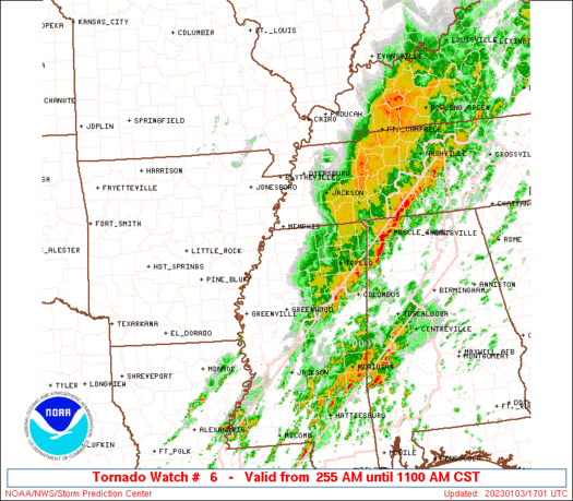
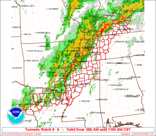
SUMMARY...A corridor of strong to occasionally severe thunderstorms
will continue to pose an intermittent tornado and damaging-gust
hazard as it shifts slowly eastward across the watch area, and
through a favorable environment, during the remainder of this
morning.
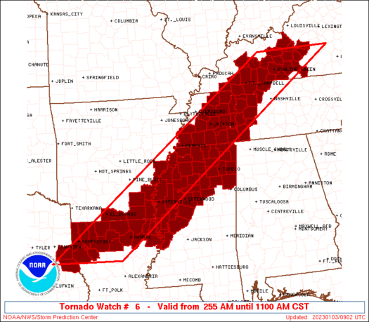
The tornado watch area is approximately along and 70 statute miles
east and west of a line from 45 miles south southeast of Shreveport
LA to 55 miles northeast of Bowling Green KY. For a complete
depiction of the watch see the associated watch outline update
(WOUS64 KWNS WOU6).
PRECAUTIONARY/PREPAREDNESS ACTIONS...
REMEMBER...A Tornado Watch means conditions are favorable for
tornadoes and severe thunderstorms in and close to the watch
area. Persons in these areas should be on the lookout for
threatening weather conditions and listen for later statements
and possible warnings.
&&
OTHER WATCH INFORMATION...This tornado watch replaces tornado
watch number 3...tornado watch number 4...tornado watch number 5.
Watch number 3 4 5 will not be in effect after 255 AM CST.
AVIATION...Tornadoes and a few severe thunderstorms with hail
surface and aloft to 1 inch. Extreme turbulence and surface wind
gusts to 60 knots. A few cumulonimbi with maximum tops to 500. Mean
storm motion vector 24035.
...Edwards
   SEL6

   URGENT - IMMEDIATE BROADCAST REQUESTED
   Tornado Watch Number 6
   NWS Storm Prediction Center Norman OK
   255 AM CST Tue Jan 3 2023

   The NWS Storm Prediction Center has issued a

   * Tornado Watch for portions of
     Southeastern Arkansas
     Southwestern and central Kentucky
     Northern Louisiana
     Western and northern Mississippi
     Western and middle Tennessee
     Extreme east Texas

   * Effective this Tuesday morning from 255 AM until 1100 AM CST.

   * Primary threats include...
     A few tornadoes possible
     Isolated damaging wind gusts to 70 mph possible

   SUMMARY...A corridor of strong to occasionally severe thunderstorms
   will continue to pose an intermittent tornado and damaging-gust
   hazard as it shifts slowly eastward across the watch area, and
   through a favorable environment, during the remainder of this
   morning.

   The tornado watch area is approximately along and 70 statute miles
   east and west of a line from 45 miles south southeast of Shreveport
   LA to 55 miles northeast of Bowling Green KY. For a complete
   depiction of the watch see the associated watch outline update
   (WOUS64 KWNS WOU6).

   PRECAUTIONARY/PREPAREDNESS ACTIONS...

   REMEMBER...A Tornado Watch means conditions are favorable for
   tornadoes and severe thunderstorms in and close to the watch
   area. Persons in these areas should be on the lookout for
   threatening weather conditions and listen for later statements
   and possible warnings.

   &&

   OTHER WATCH INFORMATION...This tornado watch replaces tornado
   watch number 3...tornado watch number 4...tornado watch number 5.
   Watch number 3 4 5 will not be in effect after 255 AM CST.

   AVIATION...Tornadoes and a few severe thunderstorms with hail
   surface and aloft to 1 inch. Extreme turbulence and surface wind
   gusts to 60 knots. A few cumulonimbi with maximum tops to 500. Mean
   storm motion vector 24035.

   ...Edwards
 Note:
The Aviation Watch (SAW) product is an approximation to the watch area.
The actual watch is depicted by the shaded areas.
Note:
The Aviation Watch (SAW) product is an approximation to the watch area.
The actual watch is depicted by the shaded areas.
   SAW6
   WW 6 TORNADO AR KY LA MS TN TX 030855Z - 031700Z
   AXIS..70 STATUTE MILES EAST AND WEST OF LINE..
   45SSE SHV/SHREVEPORT LA/ - 55NE BWG/BOWLING GREEN KY/
   ..AVIATION COORDS.. 60NM E/W /57SSE EIC - 35S IIU/
   HAIL SURFACE AND ALOFT..1 INCH. WIND GUSTS..60 KNOTS.
   MAX TOPS TO 500. MEAN STORM MOTION VECTOR 24035.

   REPLACES WW 3..AR LA MS
   REPLACES WW 4..AR LA TX
   REPLACES WW 5..AR MS TN

   LAT...LON 31849473 37528699 37528443 31849234

   THIS IS AN APPROXIMATION TO THE WATCH AREA.  FOR A
   COMPLETE DEPICTION OF THE WATCH SEE WOUS64 KWNS
   FOR WOU6.
Watch 6 Status Report Messages:
STATUS REPORT #3 ON WW 6

VALID 031550Z - 031640Z

SEVERE WEATHER THREAT CONTINUES RIGHT OF A LINE FROM 45 ENE MLU
TO 35 SSE MKL TO 40 WSW BNA TO 40 ENE BNA.

..GOSS..01/03/23

ATTN...WFO...JAN...LZK...MEG...SHV...LMK...PAH...OHX...

&&

STATUS REPORT FOR WT 6

SEVERE WEATHER THREAT CONTINUES FOR THE FOLLOWING AREAS

KYC171-031640-

KY
.    KENTUCKY COUNTIES INCLUDED ARE

MONROE
$$


LAC065-031640-

LA
.    LOUISIANA PARISHES INCLUDED ARE

MADISON
$$


MSC003-013-015-017-043-051-053-055-057-081-083-095-097-115-117-
125-139-141-145-149-155-161-163-031640-

MS
.    MISSISSIPPI COUNTIES INCLUDED ARE

ALCORN		     CALHOUN		 CARROLL
CHICKASAW	     GRENADA		 HOLMES
HUMPHREYS	     ISSAQUENA		 ITAWAMBA
LEE		     LEFLORE		 MONROE
MONTGOMERY	     PONTOTOC		 PRENTISS
SHARKEY 	     TIPPAH		 TISHOMINGO
UNION		     WARREN		 WEBSTER
YALOBUSHA	     YAZOO
$$


TNC037-039-071-081-101-109-135-181-187-031640-

TN
.    TENNESSEE COUNTIES INCLUDED ARE

DAVIDSON	     DECATUR		 HARDIN
HICKMAN 	     LEWIS		 MCNAIRY
PERRY		     WAYNE		 WILLIAMSON
$$


THE WATCH STATUS MESSAGE IS FOR GUIDANCE PURPOSES ONLY.  PLEASE
REFER TO WATCH COUNTY NOTIFICATION STATEMENTS FOR OFFICIAL
INFORMATION ON COUNTIES...INDEPENDENT CITIES AND MARINE ZONES
CLEARED FROM SEVERE THUNDERSTORM AND TORNADO WATCHES.
$$

STATUS REPORT #2 ON WW 6

VALID 031330Z - 031440Z

SEVERE WEATHER THREAT CONTINUES RIGHT OF A LINE FROM 15 W IER TO
5 E LLQ TO 15 NE HOP TO 35 SSW SDF.

..BROYLES..01/03/23

ATTN...WFO...JAN...LZK...MEG...SHV...LMK...PAH...OHX...

&&

STATUS REPORT FOR WT 6

SEVERE WEATHER THREAT CONTINUES FOR THE FOLLOWING AREAS

ARC003-017-041-043-031440-

AR
.    ARKANSAS COUNTIES INCLUDED ARE

ASHLEY		     CHICOT		 DESHA
DREW
$$


KYC001-003-009-057-061-085-087-093-099-123-141-155-169-171-179-
213-217-227-229-031440-

KY
.    KENTUCKY COUNTIES INCLUDED ARE

ADAIR		     ALLEN		 BARREN
CUMBERLAND	     EDMONSON		 GRAYSON
GREEN		     HARDIN		 HART
LARUE		     LOGAN		 MARION
METCALFE	     MONROE		 NELSON
SIMPSON 	     TAYLOR		 WARREN
WASHINGTON
$$


LAC035-049-061-065-067-073-083-111-123-031440-

LA
.    LOUISIANA PARISHES INCLUDED ARE

EAST CARROLL	     JACKSON		 LINCOLN
MADISON 	     MOREHOUSE		 OUACHITA
RICHLAND	     UNION		 WEST CARROLL
$$


MSC003-009-011-013-015-017-027-033-043-051-053-055-057-071-081-
083-093-095-097-107-115-117-119-125-133-135-137-139-141-145-149-
151-155-161-163-031440-

MS
.    MISSISSIPPI COUNTIES INCLUDED ARE

ALCORN		     BENTON		 BOLIVAR
CALHOUN 	     CARROLL		 CHICKASAW
COAHOMA 	     DESOTO		 GRENADA
HOLMES		     HUMPHREYS		 ISSAQUENA
ITAWAMBA	     LAFAYETTE		 LEE
LEFLORE 	     MARSHALL		 MONROE
MONTGOMERY	     PANOLA		 PONTOTOC
PRENTISS	     QUITMAN		 SHARKEY
SUNFLOWER	     TALLAHATCHIE	 TATE
TIPPAH		     TISHOMINGO 	 UNION
WARREN		     WASHINGTON 	 WEBSTER
YALOBUSHA	     YAZOO
$$


TNC005-017-021-023-037-039-043-047-069-071-077-081-083-085-101-
109-113-125-135-147-165-181-187-031440-

TN
.    TENNESSEE COUNTIES INCLUDED ARE

BENTON		     CARROLL		 CHEATHAM
CHESTER 	     DAVIDSON		 DECATUR
DICKSON 	     FAYETTE		 HARDEMAN
HARDIN		     HENDERSON		 HICKMAN
HOUSTON 	     HUMPHREYS		 LEWIS
MCNAIRY 	     MADISON		 MONTGOMERY
PERRY		     ROBERTSON		 SUMNER
WAYNE		     WILLIAMSON
$$


THE WATCH STATUS MESSAGE IS FOR GUIDANCE PURPOSES ONLY.  PLEASE
REFER TO WATCH COUNTY NOTIFICATION STATEMENTS FOR OFFICIAL
INFORMATION ON COUNTIES...INDEPENDENT CITIES AND MARINE ZONES
CLEARED FROM SEVERE THUNDERSTORM AND TORNADO WATCHES.
$$

STATUS REPORT #1 ON WW 6

VALID 031035Z - 031140Z

THE SEVERE WEATHER THREAT CONTINUES ACROSS THE ENTIRE WATCH AREA.

..BROYLES..01/03/23

ATTN...WFO...JAN...LZK...MEG...SHV...LMK...PAH...OHX...

&&

STATUS REPORT FOR WT 6

SEVERE WEATHER THREAT CONTINUES FOR THE FOLLOWING AREAS

ARC003-017-041-043-107-139-031140-

AR
.    ARKANSAS COUNTIES INCLUDED ARE

ASHLEY		     CHICOT		 DESHA
DREW		     PHILLIPS		 UNION
$$


KYC003-009-031-035-047-057-061-085-087-093-099-107-123-141-155-
169-177-213-217-219-221-227-031140-

KY
.    KENTUCKY COUNTIES INCLUDED ARE

ALLEN		     BARREN		 BUTLER
CALLOWAY	     CHRISTIAN		 CUMBERLAND
EDMONSON	     GRAYSON		 GREEN
HARDIN		     HART		 HOPKINS
LARUE		     LOGAN		 MARION
METCALFE	     MUHLENBERG 	 SIMPSON
TAYLOR		     TODD		 TRIGG
WARREN
$$


LAC013-015-017-027-031-035-049-061-065-067-073-081-083-111-119-
123-031140-

LA
.    LOUISIANA PARISHES INCLUDED ARE

BIENVILLE	     BOSSIER		 CADDO
CLAIBORNE	     DE SOTO		 EAST CARROLL
JACKSON 	     LINCOLN		 MADISON
MOREHOUSE	     OUACHITA		 RED RIVER
RICHLAND	     UNION		 WEBSTER
WEST CARROLL
$$


MSC003-009-011-013-015-017-027-033-043-051-053-055-057-071-081-
083-093-095-097-107-115-117-119-125-133-135-137-139-141-143-145-
149-151-155-161-163-031140-

MS
.    MISSISSIPPI COUNTIES INCLUDED ARE

ALCORN		     BENTON		 BOLIVAR
CALHOUN 	     CARROLL		 CHICKASAW
COAHOMA 	     DESOTO		 GRENADA
HOLMES		     HUMPHREYS		 ISSAQUENA
ITAWAMBA	     LAFAYETTE		 LEE
LEFLORE 	     MARSHALL		 MONROE
MONTGOMERY	     PANOLA		 PONTOTOC
PRENTISS	     QUITMAN		 SHARKEY
SUNFLOWER	     TALLAHATCHIE	 TATE
TIPPAH		     TISHOMINGO 	 TUNICA
UNION		     WARREN		 WASHINGTON
WEBSTER 	     YALOBUSHA		 YAZOO
$$


TNC005-017-021-023-033-039-043-047-053-069-071-075-077-079-081-
083-085-101-109-113-125-135-147-157-161-167-181-183-031140-

TN
.    TENNESSEE COUNTIES INCLUDED ARE

BENTON		     CARROLL		 CHEATHAM
CHESTER 	     CROCKETT		 DECATUR
DICKSON 	     FAYETTE		 GIBSON
HARDEMAN	     HARDIN		 HAYWOOD
HENDERSON	     HENRY		 HICKMAN
HOUSTON 	     HUMPHREYS		 LEWIS
MCNAIRY 	     MADISON		 MONTGOMERY
PERRY		     ROBERTSON		 SHELBY
STEWART 	     TIPTON		 WAYNE
WEAKLEY
$$


TXC365-419-031140-

TX
.    TEXAS COUNTIES INCLUDED ARE

PANOLA		     SHELBY
$$


THE WATCH STATUS MESSAGE IS FOR GUIDANCE PURPOSES ONLY.  PLEASE
REFER TO WATCH COUNTY NOTIFICATION STATEMENTS FOR OFFICIAL
INFORMATION ON COUNTIES...INDEPENDENT CITIES AND MARINE ZONES
CLEARED FROM SEVERE THUNDERSTORM AND TORNADO WATCHES.
$$
Note:
Click for Complete Product Text.
Tornadoes
Probability of 2 or more tornadoes
|
Mod (50%)
|
Probability of 1 or more strong (EF2-EF5) tornadoes
|
Low (20%)
|
Wind
Probability of 10 or more severe wind events
|
Mod (30%)
|
Probability of 1 or more wind events > 65 knots
|
Low (20%)
|
Hail
Probability of 10 or more severe hail events
|
Low (10%)
|
Probability of 1 or more hailstones > 2 inches
|
Low (10%)
|
Combined Severe Hail/Wind
Probability of 6 or more combined severe hail/wind events
|
Mod (50%)
|
For each watch, probabilities for particular events inside the watch
(listed above in each table) are determined by the issuing forecaster.
The "Low" category contains probability values ranging from less than 2%
to 20% (EF2-EF5 tornadoes), less than 5% to 20% (all other probabilities),
"Moderate" from 30% to 60%, and "High" from 70% to greater than 95%.
High values are bolded and lighter in color to provide awareness of
an increased threat for a particular event.


 @NWSSPC


