 Note:
The expiration time in the watch graphic is amended if the watch is
replaced, cancelled or extended.
Note:
Note:
The expiration time in the watch graphic is amended if the watch is
replaced, cancelled or extended.
Note: Click for
Watch Status Reports.
SEL7
URGENT - IMMEDIATE BROADCAST REQUESTED
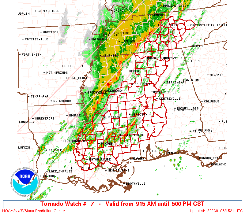
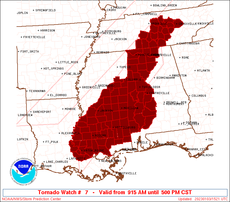
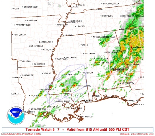
Tornado Watch Number 7
NWS Storm Prediction Center Norman OK
915 AM CST Tue Jan 3 2023
The NWS Storm Prediction Center has issued a
* Tornado Watch for portions of
Western Alabama
Southeast Louisiana
Central and Southern Mississippi
Middle Tennessee
* Effective this Tuesday morning and afternoon from 915 AM until
500 PM CST.
* Primary threats include...
A few tornadoes likely with a couple intense tornadoes possible
Scattered damaging winds likely with isolated significant gusts
to 75 mph possible
Isolated large hail events to 1 inch in diameter possible
SUMMARY...A line of thunderstorms extending from parts of Middle
Tennessee southwestward into Mississippi and Louisiana will continue
tracking eastward today across the watch area. Other isolated
thunderstorms will develop ahead of the line throughout the day.
Parameters are favorable for a risk of damaging winds and a few
tornadoes in the more intense storms through the afternoon.
The tornado watch area is approximately along and 70 statute miles
north and south of a line from 75 miles southwest of Mc Comb MS to
50 miles northeast of Huntsville AL. For a complete depiction of the
watch see the associated watch outline update (WOUS64 KWNS WOU7).
PRECAUTIONARY/PREPAREDNESS ACTIONS...
REMEMBER...A Tornado Watch means conditions are favorable for
tornadoes and severe thunderstorms in and close to the watch
area. Persons in these areas should be on the lookout for
threatening weather conditions and listen for later statements
and possible warnings.
&&
OTHER WATCH INFORMATION...CONTINUE...WW 6...
AVIATION...Tornadoes and a few severe thunderstorms with hail
surface and aloft to 1 inch. Extreme turbulence and surface wind
gusts to 65 knots. A few cumulonimbi with maximum tops to 500. Mean
storm motion vector 24035.
...Hart
 Note:
The Aviation Watch (SAW) product is an approximation to the watch area.
The actual watch is depicted by the shaded areas.
Note:
The Aviation Watch (SAW) product is an approximation to the watch area.
The actual watch is depicted by the shaded areas.
   SAW7
   WW 7 TORNADO AL LA MS TN 031515Z - 032300Z
   AXIS..70 STATUTE MILES NORTH AND SOUTH OF LINE..
   75SW MCB/MC COMB MS/ - 50NE HSV/HUNTSVILLE AL/
   ..AVIATION COORDS.. 60NM N/S /5SW BTR - 51WNW GQO/
   HAIL SURFACE AND ALOFT..1 INCH. WIND GUSTS..65 KNOTS.
   MAX TOPS TO 500. MEAN STORM MOTION VECTOR 24035.

   LAT...LON 31429136 36168615 34158615 29409136

   THIS IS AN APPROXIMATION TO THE WATCH AREA.  FOR A
   COMPLETE DEPICTION OF THE WATCH SEE WOUS64 KWNS
   FOR WOU7.
Watch 7 Status Report Messages:
STATUS REPORT #8 ON WW 7
VALID 032240Z - 032340Z
SEVERE WEATHER THREAT CONTINUES RIGHT OF A LINE FROM 50 S GWO TO
30 ESE TCL.
..WENDT..01/03/23
ATTN...WFO...BMX...MOB...HUN...LIX...JAN...OHX...
&&
STATUS REPORT FOR WT 7
SEVERE WEATHER THREAT CONTINUES FOR THE FOLLOWING AREAS
ALC023-025-099-129-131-032340-
AL
. ALABAMA COUNTIES INCLUDED ARE
CHOCTAW CLARKE MONROE
WASHINGTON WILCOX
$$
LAC005-033-037-047-063-077-091-103-105-117-121-125-032340-
LA
. LOUISIANA PARISHES INCLUDED ARE
ASCENSION EAST BATON ROUGE EAST FELICIANA
IBERVILLE LIVINGSTON POINTE COUPEE
ST. HELENA ST. TAMMANY TANGIPAHOA
WASHINGTON WEST BATON ROUGE WEST FELICIANA
$$
MSC001-005-021-023-029-031-035-037-039-041-049-061-063-065-067-
069-073-075-077-079-085-089-091-099-101-109-111-113-121-123-127-
129-131-147-153-157-032340-
MS
. MISSISSIPPI COUNTIES INCLUDED ARE
ADAMS AMITE CLAIBORNE
CLARKE COPIAH COVINGTON
FORREST FRANKLIN GEORGE
GREENE HINDS JASPER
JEFFERSON JEFFERSON DAVIS JONES
KEMPER LAMAR LAUDERDALE
LAWRENCE LEAKE LINCOLN
MADISON MARION NESHOBA
NEWTON PEARL RIVER PERRY
PIKE RANKIN SCOTT
SIMPSON SMITH STONE
WALTHALL WAYNE WILKINSON
$$
THE WATCH STATUS MESSAGE IS FOR GUIDANCE PURPOSES ONLY. PLEASE
REFER TO WATCH COUNTY NOTIFICATION STATEMENTS FOR OFFICIAL
INFORMATION ON COUNTIES...INDEPENDENT CITIES AND MARINE ZONES
CLEARED FROM SEVERE THUNDERSTORM AND TORNADO WATCHES.
$$
STATUS REPORT #7 ON WW 7
VALID 032130Z - 032240Z
SEVERE WEATHER THREAT CONTINUES RIGHT OF A LINE FROM 50 S GWO TO
30 ESE TCL.
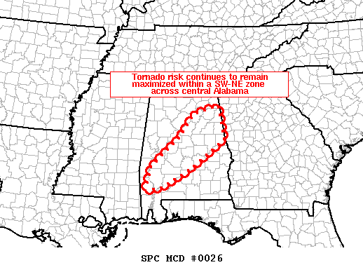
FOR ADDITIONAL INFORMATION SEE MESOSCALE DISCUSSION 26
..WEINMAN..01/03/23
ATTN...WFO...BMX...MOB...HUN...LIX...JAN...OHX...
&&
STATUS REPORT FOR WT 7
SEVERE WEATHER THREAT CONTINUES FOR THE FOLLOWING AREAS
ALC001-021-023-025-047-085-099-105-129-131-032240-
AL
. ALABAMA COUNTIES INCLUDED ARE
AUTAUGA CHILTON CHOCTAW
CLARKE DALLAS LOWNDES
MONROE PERRY WASHINGTON
WILCOX
$$
LAC005-033-037-047-063-077-091-103-105-117-121-125-032240-
LA
. LOUISIANA PARISHES INCLUDED ARE
ASCENSION EAST BATON ROUGE EAST FELICIANA
IBERVILLE LIVINGSTON POINTE COUPEE
ST. HELENA ST. TAMMANY TANGIPAHOA
WASHINGTON WEST BATON ROUGE WEST FELICIANA
$$
MSC001-005-021-023-029-031-035-037-039-041-049-061-063-065-067-
069-073-075-077-079-085-089-091-099-101-109-111-113-121-123-127-
129-131-147-153-157-032240-
MS
. MISSISSIPPI COUNTIES INCLUDED ARE
ADAMS AMITE CLAIBORNE
CLARKE COPIAH COVINGTON
FORREST FRANKLIN GEORGE
GREENE HINDS JASPER
JEFFERSON JEFFERSON DAVIS JONES
KEMPER LAMAR LAUDERDALE
LAWRENCE LEAKE LINCOLN
MADISON MARION NESHOBA
NEWTON PEARL RIVER PERRY
PIKE RANKIN SCOTT
SIMPSON SMITH STONE
WALTHALL WAYNE WILKINSON
$$
THE WATCH STATUS MESSAGE IS FOR GUIDANCE PURPOSES ONLY. PLEASE
REFER TO WATCH COUNTY NOTIFICATION STATEMENTS FOR OFFICIAL
INFORMATION ON COUNTIES...INDEPENDENT CITIES AND MARINE ZONES
CLEARED FROM SEVERE THUNDERSTORM AND TORNADO WATCHES.
$$
STATUS REPORT #6 ON WW 7
VALID 032030Z - 032140Z
SEVERE WEATHER THREAT CONTINUES RIGHT OF A LINE FROM 50 S GWO TO
15 SSE TCL TO 25 SSW BHM.
FOR ADDITIONAL INFORMATION SEE MESOSCALE DISCUSSION 26
..WEINMAN..01/03/23
ATTN...WFO...BMX...MOB...HUN...LIX...JAN...OHX...
&&
STATUS REPORT FOR WT 7
SEVERE WEATHER THREAT CONTINUES FOR THE FOLLOWING AREAS
ALC001-007-021-023-025-047-063-065-073-085-091-099-105-117-119-
129-131-032140-
AL
. ALABAMA COUNTIES INCLUDED ARE
AUTAUGA BIBB CHILTON
CHOCTAW CLARKE DALLAS
GREENE HALE JEFFERSON
LOWNDES MARENGO MONROE
PERRY SHELBY SUMTER
WASHINGTON WILCOX
$$
LAC005-033-037-047-063-077-091-103-105-117-121-125-032140-
LA
. LOUISIANA PARISHES INCLUDED ARE
ASCENSION EAST BATON ROUGE EAST FELICIANA
IBERVILLE LIVINGSTON POINTE COUPEE
ST. HELENA ST. TAMMANY TANGIPAHOA
WASHINGTON WEST BATON ROUGE WEST FELICIANA
$$
MSC001-005-021-023-029-031-035-037-039-041-049-061-063-065-067-
069-073-075-077-079-085-089-091-099-101-109-111-113-121-123-127-
129-131-147-153-157-032140-
MS
. MISSISSIPPI COUNTIES INCLUDED ARE
ADAMS AMITE CLAIBORNE
CLARKE COPIAH COVINGTON
FORREST FRANKLIN GEORGE
GREENE HINDS JASPER
JEFFERSON JEFFERSON DAVIS JONES
KEMPER LAMAR LAUDERDALE
LAWRENCE LEAKE LINCOLN
MADISON MARION NESHOBA
NEWTON PEARL RIVER PERRY
PIKE RANKIN SCOTT
SIMPSON SMITH STONE
WALTHALL WAYNE WILKINSON
$$
THE WATCH STATUS MESSAGE IS FOR GUIDANCE PURPOSES ONLY. PLEASE
REFER TO WATCH COUNTY NOTIFICATION STATEMENTS FOR OFFICIAL
INFORMATION ON COUNTIES...INDEPENDENT CITIES AND MARINE ZONES
CLEARED FROM SEVERE THUNDERSTORM AND TORNADO WATCHES.
$$
STATUS REPORT #5 ON WW 7
VALID 031945Z - 032040Z
SEVERE WEATHER THREAT CONTINUES RIGHT OF A LINE FROM 40 S GWO TO
25 NE TCL TO 20 NW CHA.
..WEINMAN..01/03/23
ATTN...WFO...BMX...MOB...HUN...LIX...JAN...OHX...
&&
STATUS REPORT FOR WT 7
SEVERE WEATHER THREAT CONTINUES FOR THE FOLLOWING AREAS
ALC001-007-009-021-023-025-047-049-063-065-071-073-085-091-095-
099-105-107-117-119-125-129-131-032040-
AL
. ALABAMA COUNTIES INCLUDED ARE
AUTAUGA BIBB BLOUNT
CHILTON CHOCTAW CLARKE
DALLAS DEKALB GREENE
HALE JACKSON JEFFERSON
LOWNDES MARENGO MARSHALL
MONROE PERRY PICKENS
SHELBY SUMTER TUSCALOOSA
WASHINGTON WILCOX
$$
LAC005-033-037-047-063-077-091-103-105-117-121-125-032040-
LA
. LOUISIANA PARISHES INCLUDED ARE
ASCENSION EAST BATON ROUGE EAST FELICIANA
IBERVILLE LIVINGSTON POINTE COUPEE
ST. HELENA ST. TAMMANY TANGIPAHOA
WASHINGTON WEST BATON ROUGE WEST FELICIANA
$$
MSC001-005-021-023-029-031-035-037-039-041-049-061-063-065-067-
069-073-075-077-079-085-089-091-099-101-103-109-111-113-121-123-
127-129-131-147-153-157-159-032040-
MS
. MISSISSIPPI COUNTIES INCLUDED ARE
ADAMS AMITE CLAIBORNE
CLARKE COPIAH COVINGTON
FORREST FRANKLIN GEORGE
GREENE HINDS JASPER
JEFFERSON JEFFERSON DAVIS JONES
KEMPER LAMAR LAUDERDALE
LAWRENCE LEAKE LINCOLN
MADISON MARION NESHOBA
NEWTON NOXUBEE PEARL RIVER
PERRY PIKE RANKIN
SCOTT SIMPSON SMITH
STONE WALTHALL WAYNE
WILKINSON WINSTON
$$
THE WATCH STATUS MESSAGE IS FOR GUIDANCE PURPOSES ONLY. PLEASE
REFER TO WATCH COUNTY NOTIFICATION STATEMENTS FOR OFFICIAL
INFORMATION ON COUNTIES...INDEPENDENT CITIES AND MARINE ZONES
CLEARED FROM SEVERE THUNDERSTORM AND TORNADO WATCHES.
$$
STATUS REPORT #4 ON WW 7
VALID 031835Z - 031940Z
SEVERE WEATHER THREAT CONTINUES RIGHT OF A LINE FROM 15 E TUP TO
25 SSW MSL TO 40 W CSV.
FOR ADDITIONAL INFORMATION SEE MESOSCALE DISCUSSION 22
..WEINMAN..01/03/23
ATTN...WFO...BMX...MOB...HUN...LIX...JAN...OHX...
&&
STATUS REPORT FOR WT 7
SEVERE WEATHER THREAT CONTINUES FOR THE FOLLOWING AREAS
ALC001-007-009-021-023-025-043-047-049-057-063-065-071-073-075-
079-083-085-089-091-093-095-099-103-105-107-117-119-125-127-129-
131-133-031940-
AL
. ALABAMA COUNTIES INCLUDED ARE
AUTAUGA BIBB BLOUNT
CHILTON CHOCTAW CLARKE
CULLMAN DALLAS DEKALB
FAYETTE GREENE HALE
JACKSON JEFFERSON LAMAR
LAWRENCE LIMESTONE LOWNDES
MADISON MARENGO MARION
MARSHALL MONROE MORGAN
PERRY PICKENS SHELBY
SUMTER TUSCALOOSA WALKER
WASHINGTON WILCOX WINSTON
$$
LAC005-033-037-047-063-077-091-103-105-117-121-125-031940-
LA
. LOUISIANA PARISHES INCLUDED ARE
ASCENSION EAST BATON ROUGE EAST FELICIANA
IBERVILLE LIVINGSTON POINTE COUPEE
ST. HELENA ST. TAMMANY TANGIPAHOA
WASHINGTON WEST BATON ROUGE WEST FELICIANA
$$
MSC001-005-007-019-021-023-025-029-031-035-037-039-041-049-061-
063-065-067-069-073-075-077-079-085-087-089-091-099-101-103-105-
109-111-113-121-123-127-129-131-147-153-157-159-031940-
MS
. MISSISSIPPI COUNTIES INCLUDED ARE
ADAMS AMITE ATTALA
CHOCTAW CLAIBORNE CLARKE
CLAY COPIAH COVINGTON
FORREST FRANKLIN GEORGE
GREENE HINDS JASPER
JEFFERSON JEFFERSON DAVIS JONES
KEMPER LAMAR LAUDERDALE
LAWRENCE LEAKE LINCOLN
LOWNDES MADISON MARION
NESHOBA NEWTON NOXUBEE
OKTIBBEHA PEARL RIVER PERRY
PIKE RANKIN SCOTT
SIMPSON SMITH STONE
WALTHALL WAYNE WILKINSON
WINSTON
$$
TNC031-035-051-061-103-127-141-175-177-185-031940-
TN
. TENNESSEE COUNTIES INCLUDED ARE
COFFEE CUMBERLAND FRANKLIN
GRUNDY LINCOLN MOORE
PUTNAM VAN BUREN WARREN
WHITE
$$
THE WATCH STATUS MESSAGE IS FOR GUIDANCE PURPOSES ONLY. PLEASE
REFER TO WATCH COUNTY NOTIFICATION STATEMENTS FOR OFFICIAL
INFORMATION ON COUNTIES...INDEPENDENT CITIES AND MARINE ZONES
CLEARED FROM SEVERE THUNDERSTORM AND TORNADO WATCHES.
$$
STATUS REPORT #3 ON WW 7
VALID 031725Z - 031840Z
THE SEVERE WEATHER THREAT CONTINUES ACROSS THE ENTIRE WATCH AREA.
..WEINMAN..01/03/23
ATTN...WFO...BMX...MOB...HUN...LIX...JAN...OHX...
&&
STATUS REPORT FOR WT 7
SEVERE WEATHER THREAT CONTINUES FOR THE FOLLOWING AREAS
ALC007-023-025-033-043-047-057-059-063-065-075-077-079-083-089-
091-093-099-103-105-107-119-125-127-129-131-133-031840-
AL
. ALABAMA COUNTIES INCLUDED ARE
BIBB CHOCTAW CLARKE
COLBERT CULLMAN DALLAS
FAYETTE FRANKLIN GREENE
HALE LAMAR LAUDERDALE
LAWRENCE LIMESTONE MADISON
MARENGO MARION MONROE
MORGAN PERRY PICKENS
SUMTER TUSCALOOSA WALKER
WASHINGTON WILCOX WINSTON
$$
LAC005-033-037-047-063-077-091-103-105-117-121-125-031840-
LA
. LOUISIANA PARISHES INCLUDED ARE
ASCENSION EAST BATON ROUGE EAST FELICIANA
IBERVILLE LIVINGSTON POINTE COUPEE
ST. HELENA ST. TAMMANY TANGIPAHOA
WASHINGTON WEST BATON ROUGE WEST FELICIANA
$$
MSC001-005-007-019-021-023-025-029-031-035-037-039-041-049-061-
063-065-067-069-073-075-077-079-085-087-089-091-099-101-103-105-
109-111-113-121-123-127-129-131-147-153-157-159-031840-
MS
. MISSISSIPPI COUNTIES INCLUDED ARE
ADAMS AMITE ATTALA
CHOCTAW CLAIBORNE CLARKE
CLAY COPIAH COVINGTON
FORREST FRANKLIN GEORGE
GREENE HINDS JASPER
JEFFERSON JEFFERSON DAVIS JONES
KEMPER LAMAR LAUDERDALE
LAWRENCE LEAKE LINCOLN
LOWNDES MADISON MARION
NESHOBA NEWTON NOXUBEE
OKTIBBEHA PEARL RIVER PERRY
PIKE RANKIN SCOTT
SIMPSON SMITH STONE
WALTHALL WAYNE WILKINSON
WINSTON
$$
TNC003-015-031-035-041-051-055-061-099-103-117-119-127-141-149-
159-175-177-185-189-031840-
TN
. TENNESSEE COUNTIES INCLUDED ARE
BEDFORD CANNON COFFEE
CUMBERLAND DE KALB FRANKLIN
GILES GRUNDY LAWRENCE
LINCOLN MARSHALL MAURY
MOORE PUTNAM RUTHERFORD
SMITH VAN BUREN WARREN
WHITE WILSON
$$
THE WATCH STATUS MESSAGE IS FOR GUIDANCE PURPOSES ONLY. PLEASE
REFER TO WATCH COUNTY NOTIFICATION STATEMENTS FOR OFFICIAL
INFORMATION ON COUNTIES...INDEPENDENT CITIES AND MARINE ZONES
CLEARED FROM SEVERE THUNDERSTORM AND TORNADO WATCHES.
$$
STATUS REPORT #2 ON WW 7
VALID 031625Z - 031740Z
THE SEVERE WEATHER THREAT CONTINUES ACROSS THE ENTIRE WATCH AREA.
..WEINMAN..01/03/23
ATTN...WFO...BMX...MOB...HUN...LIX...JAN...OHX...
&&
STATUS REPORT FOR WT 7
SEVERE WEATHER THREAT CONTINUES FOR THE FOLLOWING AREAS
ALC007-023-025-033-043-047-057-059-063-065-075-077-079-083-089-
091-093-099-103-105-107-119-125-127-129-131-133-031740-
AL
. ALABAMA COUNTIES INCLUDED ARE
BIBB CHOCTAW CLARKE
COLBERT CULLMAN DALLAS
FAYETTE FRANKLIN GREENE
HALE LAMAR LAUDERDALE
LAWRENCE LIMESTONE MADISON
MARENGO MARION MONROE
MORGAN PERRY PICKENS
SUMTER TUSCALOOSA WALKER
WASHINGTON WILCOX WINSTON
$$
LAC005-033-037-047-063-077-091-103-105-117-121-125-031740-
LA
. LOUISIANA PARISHES INCLUDED ARE
ASCENSION EAST BATON ROUGE EAST FELICIANA
IBERVILLE LIVINGSTON POINTE COUPEE
ST. HELENA ST. TAMMANY TANGIPAHOA
WASHINGTON WEST BATON ROUGE WEST FELICIANA
$$
MSC001-005-007-019-021-023-025-029-031-035-037-039-041-049-061-
063-065-067-069-073-075-077-079-085-087-089-091-099-101-103-105-
109-111-113-121-123-127-129-131-147-153-157-159-031740-
MS
. MISSISSIPPI COUNTIES INCLUDED ARE
ADAMS AMITE ATTALA
CHOCTAW CLAIBORNE CLARKE
CLAY COPIAH COVINGTON
FORREST FRANKLIN GEORGE
GREENE HINDS JASPER
JEFFERSON JEFFERSON DAVIS JONES
KEMPER LAMAR LAUDERDALE
LAWRENCE LEAKE LINCOLN
LOWNDES MADISON MARION
NESHOBA NEWTON NOXUBEE
OKTIBBEHA PEARL RIVER PERRY
PIKE RANKIN SCOTT
SIMPSON SMITH STONE
WALTHALL WAYNE WILKINSON
WINSTON
$$
TNC003-015-031-035-041-051-055-061-099-103-117-119-127-141-149-
159-175-177-185-189-031740-
TN
. TENNESSEE COUNTIES INCLUDED ARE
BEDFORD CANNON COFFEE
CUMBERLAND DE KALB FRANKLIN
GILES GRUNDY LAWRENCE
LINCOLN MARSHALL MAURY
MOORE PUTNAM RUTHERFORD
SMITH VAN BUREN WARREN
WHITE WILSON
$$
THE WATCH STATUS MESSAGE IS FOR GUIDANCE PURPOSES ONLY. PLEASE
REFER TO WATCH COUNTY NOTIFICATION STATEMENTS FOR OFFICIAL
INFORMATION ON COUNTIES...INDEPENDENT CITIES AND MARINE ZONES
CLEARED FROM SEVERE THUNDERSTORM AND TORNADO WATCHES.
$$
STATUS REPORT #1 ON WW 7
VALID 031555Z - 031640Z
THE SEVERE WEATHER THREAT CONTINUES ACROSS THE ENTIRE WATCH AREA.
..GOSS..01/03/23
ATTN...WFO...BMX...MOB...HUN...LIX...JAN...OHX...
&&
STATUS REPORT FOR WT 7
SEVERE WEATHER THREAT CONTINUES FOR THE FOLLOWING AREAS
ALC007-023-025-033-043-047-057-059-063-065-075-077-079-083-089-
091-093-099-103-105-107-119-125-127-129-131-133-031640-
AL
. ALABAMA COUNTIES INCLUDED ARE
BIBB CHOCTAW CLARKE
COLBERT CULLMAN DALLAS
FAYETTE FRANKLIN GREENE
HALE LAMAR LAUDERDALE
LAWRENCE LIMESTONE MADISON
MARENGO MARION MONROE
MORGAN PERRY PICKENS
SUMTER TUSCALOOSA WALKER
WASHINGTON WILCOX WINSTON
$$
LAC005-033-037-047-063-077-091-103-105-117-121-125-031640-
LA
. LOUISIANA PARISHES INCLUDED ARE
ASCENSION EAST BATON ROUGE EAST FELICIANA
IBERVILLE LIVINGSTON POINTE COUPEE
ST. HELENA ST. TAMMANY TANGIPAHOA
WASHINGTON WEST BATON ROUGE WEST FELICIANA
$$
MSC001-005-007-019-021-023-025-029-031-035-037-039-041-049-061-
063-065-067-069-073-075-077-079-085-087-089-091-099-101-103-105-
109-111-113-121-123-127-129-131-147-153-157-159-031640-
MS
. MISSISSIPPI COUNTIES INCLUDED ARE
ADAMS AMITE ATTALA
CHOCTAW CLAIBORNE CLARKE
CLAY COPIAH COVINGTON
FORREST FRANKLIN GEORGE
GREENE HINDS JASPER
JEFFERSON JEFFERSON DAVIS JONES
KEMPER LAMAR LAUDERDALE
LAWRENCE LEAKE LINCOLN
LOWNDES MADISON MARION
NESHOBA NEWTON NOXUBEE
OKTIBBEHA PEARL RIVER PERRY
PIKE RANKIN SCOTT
SIMPSON SMITH STONE
WALTHALL WAYNE WILKINSON
WINSTON
$$
TNC003-015-031-035-041-051-055-061-099-103-117-119-127-141-149-
159-175-177-185-189-031640-
TN
. TENNESSEE COUNTIES INCLUDED ARE
BEDFORD CANNON COFFEE
CUMBERLAND DE KALB FRANKLIN
GILES GRUNDY LAWRENCE
LINCOLN MARSHALL MAURY
MOORE PUTNAM RUTHERFORD
SMITH VAN BUREN WARREN
WHITE WILSON
$$
THE WATCH STATUS MESSAGE IS FOR GUIDANCE PURPOSES ONLY. PLEASE
REFER TO WATCH COUNTY NOTIFICATION STATEMENTS FOR OFFICIAL
INFORMATION ON COUNTIES...INDEPENDENT CITIES AND MARINE ZONES
CLEARED FROM SEVERE THUNDERSTORM AND TORNADO WATCHES.
$$
Note:
Click for Complete Product Text.
Tornadoes
Probability of 2 or more tornadoes
|
Mod (60%)
|
Probability of 1 or more strong (EF2-EF5) tornadoes
|
Mod (40%)
|
Wind
Probability of 10 or more severe wind events
|
Mod (60%)
|
Probability of 1 or more wind events > 65 knots
|
Mod (30%)
|
Hail
Probability of 10 or more severe hail events
|
Low (20%)
|
Probability of 1 or more hailstones > 2 inches
|
Low (20%)
|
Combined Severe Hail/Wind
Probability of 6 or more combined severe hail/wind events
|
High (80%)
|
For each watch, probabilities for particular events inside the watch
(listed above in each table) are determined by the issuing forecaster.
The "Low" category contains probability values ranging from less than 2%
to 20% (EF2-EF5 tornadoes), less than 5% to 20% (all other probabilities),
"Moderate" from 30% to 60%, and "High" from 70% to greater than 95%.
High values are bolded and lighter in color to provide awareness of
an increased threat for a particular event.


 @NWSSPC