 Note:
The expiration time in the watch graphic is amended if the watch is
replaced, cancelled or extended.
Note:
Note:
The expiration time in the watch graphic is amended if the watch is
replaced, cancelled or extended.
Note: Click for
Watch Status Reports.
SEL8
URGENT - IMMEDIATE BROADCAST REQUESTED
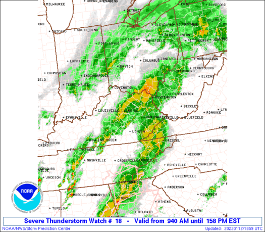
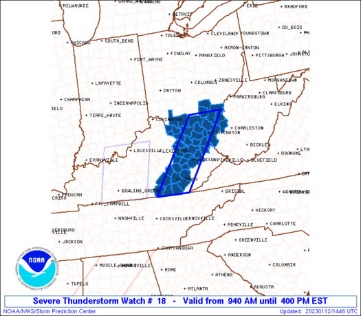
Severe Thunderstorm Watch Number 18
NWS Storm Prediction Center Norman OK
940 AM EST Thu Jan 12 2023
The NWS Storm Prediction Center has issued a
* Severe Thunderstorm Watch for portions of
Eastern Kentucky
Southern Ohio
Western West Virginia
* Effective this Thursday morning and afternoon from 940 AM until
400 PM EST.
* Primary threats include...
Scattered damaging wind gusts to 65 mph possible
Isolated large hail events to 1 inch in diameter possible
A tornado or two possible
SUMMARY...A fast-moving line of storms will continue to move
east-northeastward across the region this afternoon. Instability is
weak but very strong atmospheric winds will support storms capable
of localized wind damage.
The severe thunderstorm watch area is approximately along and 35
statute miles east and west of a line from 45 miles north of
Huntington WV to 35 miles south southwest of London KY. For a
complete depiction of the watch see the associated watch outline
update (WOUS64 KWNS WOU8).
PRECAUTIONARY/PREPAREDNESS ACTIONS...
REMEMBER...A Severe Thunderstorm Watch means conditions are
favorable for severe thunderstorms in and close to the watch area.
Persons in these areas should be on the lookout for threatening
weather conditions and listen for later statements and possible
warnings. Severe thunderstorms can and occasionally do produce
tornadoes.
&&
OTHER WATCH INFORMATION...CONTINUE...WW 16...WW 17...
AVIATION...A few severe thunderstorms with hail surface and aloft to
1 inch. Extreme turbulence and surface wind gusts to 55 knots. A few
cumulonimbi with maximum tops to 400. Mean storm motion vector
23040.
...Guyer
 Note:
The Aviation Watch (SAW) product is an approximation to the watch area.
The actual watch is depicted by the shaded areas.
Note:
The Aviation Watch (SAW) product is an approximation to the watch area.
The actual watch is depicted by the shaded areas.
   SAW8
   WW 18 SEVERE TSTM KY OH WV 121440Z - 122100Z
   AXIS..35 STATUTE MILES EAST AND WEST OF LINE..
   45N HTS/HUNTINGTON WV/ - 35SSW LOZ/LONDON KY/
   ..AVIATION COORDS.. 30NM E/W /29WNW HNN - 27SSW LOZ/
   HAIL SURFACE AND ALOFT..1 INCH. WIND GUSTS..55 KNOTS.
   MAX TOPS TO 400. MEAN STORM MOTION VECTOR 23040.

   LAT...LON 39008190 36618369 36618495 39008320

   THIS IS AN APPROXIMATION TO THE WATCH AREA.  FOR A
   COMPLETE DEPICTION OF THE WATCH SEE WOUS64 KWNS
   FOR WOU8.
Watch 18 Status Report Messages:
STATUS REPORT #3 ON WW 18

VALID 121830Z - 121940Z

SEVERE WEATHER THREAT CONTINUES RIGHT OF A LINE FROM 30 SE LEX TO
30 NNW JKL TO 25 WSW HTS TO 5 WSW CRW.

FOR ADDITIONAL INFORMATION SEE MESOSCALE DISCUSSION 54

..MOORE..01/12/23

ATTN...WFO...JKL...RLX...ILN...

&&

STATUS REPORT FOR WS 18

SEVERE WEATHER THREAT CONTINUES FOR THE FOLLOWING AREAS

KYC025-051-063-065-109-115-121-125-127-129-147-153-175-189-197-
199-203-231-235-237-121940-

KY
.    KENTUCKY COUNTIES INCLUDED ARE

BREATHITT	     CLAY		 ELLIOTT
ESTILL		     JACKSON		 JOHNSON
KNOX		     LAUREL		 LAWRENCE
LEE		     MCCREARY		 MAGOFFIN
MORGAN		     OWSLEY		 POWELL
PULASKI 	     ROCKCASTLE 	 WAYNE
WHITLEY 	     WOLFE
$$


WVC099-121940-

WV
.    WEST VIRGINIA COUNTIES INCLUDED ARE

WAYNE
$$


THE WATCH STATUS MESSAGE IS FOR GUIDANCE PURPOSES ONLY.  PLEASE
REFER TO WATCH COUNTY NOTIFICATION STATEMENTS FOR OFFICIAL
INFORMATION ON COUNTIES...INDEPENDENT CITIES AND MARINE ZONES
CLEARED FROM SEVERE THUNDERSTORM AND TORNADO WATCHES.
$$

STATUS REPORT #2 ON WW 18

VALID 121735Z - 121840Z

SEVERE WEATHER THREAT CONTINUES RIGHT OF A LINE FROM 35 NE LEX TO
15 NNE HTS TO 10 SW PKB.

..MOORE..01/12/23

ATTN...WFO...JKL...RLX...ILN...

&&

STATUS REPORT FOR WS 18

SEVERE WEATHER THREAT CONTINUES FOR THE FOLLOWING AREAS

KYC011-019-025-043-051-063-065-109-115-121-125-127-129-147-153-
165-173-175-189-197-199-203-205-231-235-237-121840-

KY
.    KENTUCKY COUNTIES INCLUDED ARE

BATH		     BOYD		 BREATHITT
CARTER		     CLAY		 ELLIOTT
ESTILL		     JACKSON		 JOHNSON
KNOX		     LAUREL		 LAWRENCE
LEE		     MCCREARY		 MAGOFFIN
MENIFEE 	     MONTGOMERY 	 MORGAN
OWSLEY		     POWELL		 PULASKI
ROCKCASTLE	     ROWAN		 WAYNE
WHITLEY 	     WOLFE
$$


WVC011-053-079-099-121840-

WV
.    WEST VIRGINIA COUNTIES INCLUDED ARE

CABELL		     MASON		 PUTNAM
WAYNE
$$


THE WATCH STATUS MESSAGE IS FOR GUIDANCE PURPOSES ONLY.  PLEASE
REFER TO WATCH COUNTY NOTIFICATION STATEMENTS FOR OFFICIAL
INFORMATION ON COUNTIES...INDEPENDENT CITIES AND MARINE ZONES
CLEARED FROM SEVERE THUNDERSTORM AND TORNADO WATCHES.
$$

STATUS REPORT #1 ON WW 18

VALID 121550Z - 121640Z

SEVERE WEATHER THREAT CONTINUES RIGHT OF A LINE FROM 30 NE LEX TO
50 ENE LEX TO 50 E LUK.

..THORNTON..01/12/23

ATTN...WFO...JKL...RLX...ILN...

&&

STATUS REPORT FOR WS 18

SEVERE WEATHER THREAT CONTINUES FOR THE FOLLOWING AREAS

KYC011-019-025-043-051-063-065-089-109-115-121-125-127-129-135-
147-153-165-173-175-189-197-199-203-205-231-235-237-121640-

KY
.    KENTUCKY COUNTIES INCLUDED ARE

BATH		     BOYD		 BREATHITT
CARTER		     CLAY		 ELLIOTT
ESTILL		     GREENUP		 JACKSON
JOHNSON 	     KNOX		 LAUREL
LAWRENCE	     LEE		 LEWIS
MCCREARY	     MAGOFFIN		 MENIFEE
MONTGOMERY	     MORGAN		 OWSLEY
POWELL		     PULASKI		 ROCKCASTLE
ROWAN		     WAYNE		 WHITLEY
WOLFE
$$


OHC001-053-079-087-105-145-163-121640-

OH
.    OHIO COUNTIES INCLUDED ARE

ADAMS		     GALLIA		 JACKSON
LAWRENCE	     MEIGS		 SCIOTO
VINTON
$$


WVC011-053-079-099-121640-

WV
.    WEST VIRGINIA COUNTIES INCLUDED ARE

CABELL		     MASON		 PUTNAM
WAYNE
$$


THE WATCH STATUS MESSAGE IS FOR GUIDANCE PURPOSES ONLY.  PLEASE
REFER TO WATCH COUNTY NOTIFICATION STATEMENTS FOR OFFICIAL
INFORMATION ON COUNTIES...INDEPENDENT CITIES AND MARINE ZONES
CLEARED FROM SEVERE THUNDERSTORM AND TORNADO WATCHES.
$$
Note:
Click for Complete Product Text.
Tornadoes
Probability of 2 or more tornadoes
|
Low (20%)
|
Probability of 1 or more strong (EF2-EF5) tornadoes
|
Low (5%)
|
Wind
Probability of 10 or more severe wind events
|
Mod (50%)
|
Probability of 1 or more wind events > 65 knots
|
Low (10%)
|
Hail
Probability of 10 or more severe hail events
|
Low (20%)
|
Probability of 1 or more hailstones > 2 inches
|
Low (<5%)
|
Combined Severe Hail/Wind
Probability of 6 or more combined severe hail/wind events
|
High (70%)
|
For each watch, probabilities for particular events inside the watch
(listed above in each table) are determined by the issuing forecaster.
The "Low" category contains probability values ranging from less than 2%
to 20% (EF2-EF5 tornadoes), less than 5% to 20% (all other probabilities),
"Moderate" from 30% to 60%, and "High" from 70% to greater than 95%.
High values are bolded and lighter in color to provide awareness of
an increased threat for a particular event.


 @NWSSPC


