 Note:
The expiration time in the watch graphic is amended if the watch is
replaced, cancelled or extended.
Note:
Note:
The expiration time in the watch graphic is amended if the watch is
replaced, cancelled or extended.
Note: Click for
Watch Status Reports.
SEL6
URGENT - IMMEDIATE BROADCAST REQUESTED
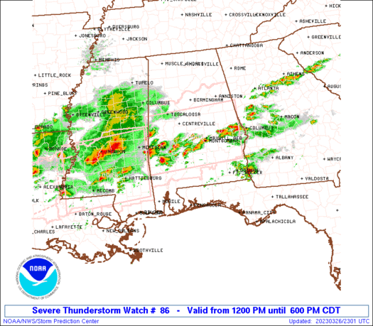
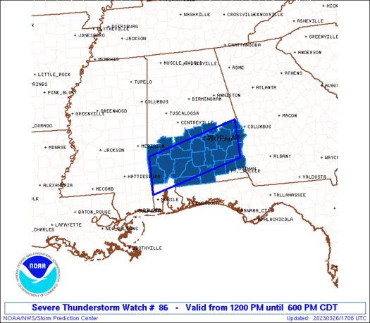
Severe Thunderstorm Watch Number 86
NWS Storm Prediction Center Norman OK
1200 PM CDT Sun Mar 26 2023
The NWS Storm Prediction Center has issued a
* Severe Thunderstorm Watch for portions of
Southern Alabama
* Effective this Sunday afternoon and evening from NOON until 600
PM CDT.
* Primary threats include...
Scattered damaging wind gusts to 65 mph possible
Scattered large hail events to 1.5 inches in diameter possible
A tornado or two possible
SUMMARY...Some severe potential may persist and somewhat increase
this afternoon across southern Alabama as temperatures warm and the
air mass destabilizes. Isolated instances of large hail and damaging
winds are the most probable hazards this afternoon. The tornado
potential is expected to increase across parts of the region later
into the evening.
The severe thunderstorm watch area is approximately along and 40
statute miles north and south of a line from 80 miles west of
Evergreen AL to 30 miles south southeast of Auburn AL. For a
complete depiction of the watch see the associated watch outline
update (WOUS64 KWNS WOU6).
PRECAUTIONARY/PREPAREDNESS ACTIONS...
REMEMBER...A Severe Thunderstorm Watch means conditions are
favorable for severe thunderstorms in and close to the watch area.
Persons in these areas should be on the lookout for threatening
weather conditions and listen for later statements and possible
warnings. Severe thunderstorms can and occasionally do produce
tornadoes.
&&
OTHER WATCH INFORMATION...CONTINUE...WW 84...WW 85...
AVIATION...A few severe thunderstorms with hail surface and aloft to
1.5 inches. Extreme turbulence and surface wind gusts to 55 knots. A
few cumulonimbi with maximum tops to 500. Mean storm motion vector
25025.
...Guyer
 Note:
The Aviation Watch (SAW) product is an approximation to the watch area.
The actual watch is depicted by the shaded areas.
Note:
The Aviation Watch (SAW) product is an approximation to the watch area.
The actual watch is depicted by the shaded areas.
   SAW6
   WW 86 SEVERE TSTM AL 261700Z - 262300Z
   AXIS..40 STATUTE MILES NORTH AND SOUTH OF LINE..
   80W GZH/EVERGREEN AL/ - 30SSE AUO/AUBURN AL/
   ..AVIATION COORDS.. 35NM N/S /41N SJI - 51S LGC/
   HAIL SURFACE AND ALOFT..1.5 INCHES. WIND GUSTS..55 KNOTS.
   MAX TOPS TO 500. MEAN STORM MOTION VECTOR 25025.

   LAT...LON 31998840 32798523 31638523 30838840

   THIS IS AN APPROXIMATION TO THE WATCH AREA.  FOR A
   COMPLETE DEPICTION OF THE WATCH SEE WOUS64 KWNS
   FOR WOU6.
Watch 86 Status Report Messages:
STATUS REPORT #6 ON WW 86

VALID 262245Z - 262300Z

SEVERE WEATHER THREAT CONTINUES RIGHT OF A LINE FROM 5 NW CEW TO
35 WSW ABY.

WW 86 WILL BE ALLOWED TO EXPIRE AT 262300Z.

..THORNTON..03/26/23

ATTN...WFO...BMX...MOB...TAE...

&&

STATUS REPORT FOR WS 86

SEVERE WEATHER THREAT CONTINUES FOR THE FOLLOWING AREAS

ALC001-005-011-013-023-025-031-035-041-045-047-051-061-067-081-
085-087-091-099-101-109-113-129-131-262300-

AL
.    ALABAMA COUNTIES INCLUDED ARE

AUTAUGA 	     BARBOUR		 BULLOCK
BUTLER		     CHOCTAW		 CLARKE
COFFEE		     CONECUH		 CRENSHAW
DALE		     DALLAS		 ELMORE
GENEVA		     HENRY		 LEE
LOWNDES 	     MACON		 MARENGO
MONROE		     MONTGOMERY 	 PIKE
RUSSELL 	     WASHINGTON 	 WILCOX
$$


THE WATCH STATUS MESSAGE IS FOR GUIDANCE PURPOSES ONLY.  PLEASE
REFER TO WATCH COUNTY NOTIFICATION STATEMENTS FOR OFFICIAL
INFORMATION ON COUNTIES...INDEPENDENT CITIES AND MARINE ZONES
CLEARED FROM SEVERE THUNDERSTORM AND TORNADO WATCHES.
$$

STATUS REPORT #5 ON WW 86

VALID 262135Z - 262240Z

THE SEVERE WEATHER THREAT CONTINUES ACROSS THE ENTIRE WATCH AREA.

..THORNTON..03/26/23

ATTN...WFO...BMX...MOB...TAE...

&&

STATUS REPORT FOR WS 86

SEVERE WEATHER THREAT CONTINUES FOR THE FOLLOWING AREAS

ALC001-003-005-011-013-023-025-031-035-039-041-045-047-051-053-
061-067-069-081-085-087-091-097-099-101-109-113-129-131-
262240-

AL
.    ALABAMA COUNTIES INCLUDED ARE

AUTAUGA 	     BALDWIN		 BARBOUR
BULLOCK 	     BUTLER		 CHOCTAW
CLARKE		     COFFEE		 CONECUH
COVINGTON	     CRENSHAW		 DALE
DALLAS		     ELMORE		 ESCAMBIA
GENEVA		     HENRY		 HOUSTON
LEE		     LOWNDES		 MACON
MARENGO 	     MOBILE		 MONROE
MONTGOMERY	     PIKE		 RUSSELL
WASHINGTON	     WILCOX
$$


FLC033-059-063-091-113-131-133-262240-

FL
.    FLORIDA COUNTIES INCLUDED ARE

ESCAMBIA	     HOLMES		 JACKSON
OKALOOSA	     SANTA ROSA 	 WALTON
WASHINGTON
$$


GMZ630-262240-

CW

.    ADJACENT COASTAL WATERS INCLUDED ARE

GMZ630

$$
THE WATCH STATUS MESSAGE IS FOR GUIDANCE PURPOSES ONLY.  PLEASE
REFER TO WATCH COUNTY NOTIFICATION STATEMENTS FOR OFFICIAL
INFORMATION ON COUNTIES...INDEPENDENT CITIES AND MARINE ZONES
CLEARED FROM SEVERE THUNDERSTORM AND TORNADO WATCHES.
$$

STATUS REPORT #4 ON WW 86

VALID 262035Z - 262140Z

THE SEVERE WEATHER THREAT CONTINUES ACROSS THE ENTIRE WATCH AREA.

FOR ADDITIONAL INFORMATION SEE MESOSCALE DISCUSSION 358

..THORNTON..03/26/23

ATTN...WFO...BMX...MOB...TAE...

&&

STATUS REPORT FOR WS 86

SEVERE WEATHER THREAT CONTINUES FOR THE FOLLOWING AREAS

ALC001-003-005-011-013-023-025-031-035-039-041-045-047-051-053-
061-067-069-081-085-087-091-097-099-101-109-113-129-131-
262140-

AL
.    ALABAMA COUNTIES INCLUDED ARE

AUTAUGA 	     BALDWIN		 BARBOUR
BULLOCK 	     BUTLER		 CHOCTAW
CLARKE		     COFFEE		 CONECUH
COVINGTON	     CRENSHAW		 DALE
DALLAS		     ELMORE		 ESCAMBIA
GENEVA		     HENRY		 HOUSTON
LEE		     LOWNDES		 MACON
MARENGO 	     MOBILE		 MONROE
MONTGOMERY	     PIKE		 RUSSELL
WASHINGTON	     WILCOX
$$


FLC033-059-063-091-113-131-133-262140-

FL
.    FLORIDA COUNTIES INCLUDED ARE

ESCAMBIA	     HOLMES		 JACKSON
OKALOOSA	     SANTA ROSA 	 WALTON
WASHINGTON
$$


GMZ630-262140-

CW

.    ADJACENT COASTAL WATERS INCLUDED ARE

GMZ630

$$
THE WATCH STATUS MESSAGE IS FOR GUIDANCE PURPOSES ONLY.  PLEASE
REFER TO WATCH COUNTY NOTIFICATION STATEMENTS FOR OFFICIAL
INFORMATION ON COUNTIES...INDEPENDENT CITIES AND MARINE ZONES
CLEARED FROM SEVERE THUNDERSTORM AND TORNADO WATCHES.
$$

STATUS REPORT #3 ON WW 86

VALID 261935Z - 262040Z

THE SEVERE WEATHER THREAT CONTINUES ACROSS THE ENTIRE WATCH AREA.

FOR ADDITIONAL INFORMATION SEE MESOSCALE DISCUSSION 358

..THORNTON..03/26/23

ATTN...WFO...BMX...MOB...TAE...

&&

STATUS REPORT FOR WS 86

SEVERE WEATHER THREAT CONTINUES FOR THE FOLLOWING AREAS

ALC001-003-005-011-013-023-025-031-035-039-041-045-047-051-053-
061-067-069-081-085-087-091-097-099-101-109-113-129-131-
262040-

AL
.    ALABAMA COUNTIES INCLUDED ARE

AUTAUGA 	     BALDWIN		 BARBOUR
BULLOCK 	     BUTLER		 CHOCTAW
CLARKE		     COFFEE		 CONECUH
COVINGTON	     CRENSHAW		 DALE
DALLAS		     ELMORE		 ESCAMBIA
GENEVA		     HENRY		 HOUSTON
LEE		     LOWNDES		 MACON
MARENGO 	     MOBILE		 MONROE
MONTGOMERY	     PIKE		 RUSSELL
WASHINGTON	     WILCOX
$$


FLC033-059-063-091-113-131-133-262040-

FL
.    FLORIDA COUNTIES INCLUDED ARE

ESCAMBIA	     HOLMES		 JACKSON
OKALOOSA	     SANTA ROSA 	 WALTON
WASHINGTON
$$


GMZ630-262040-

CW

.    ADJACENT COASTAL WATERS INCLUDED ARE

GMZ630

$$
THE WATCH STATUS MESSAGE IS FOR GUIDANCE PURPOSES ONLY.  PLEASE
REFER TO WATCH COUNTY NOTIFICATION STATEMENTS FOR OFFICIAL
INFORMATION ON COUNTIES...INDEPENDENT CITIES AND MARINE ZONES
CLEARED FROM SEVERE THUNDERSTORM AND TORNADO WATCHES.
$$

STATUS REPORT #2 ON WW 86

VALID 261835Z - 261940Z

THE SEVERE WEATHER THREAT CONTINUES ACROSS THE ENTIRE WATCH AREA.

FOR ADDITIONAL INFORMATION SEE MESOSCALE DISCUSSION 355

..THORNTON..03/26/23

ATTN...WFO...BMX...MOB...TAE...

&&

STATUS REPORT FOR WS 86

SEVERE WEATHER THREAT CONTINUES FOR THE FOLLOWING AREAS

ALC001-003-005-011-013-023-025-031-035-039-041-045-047-051-053-
067-081-085-087-091-097-099-101-109-113-129-131-261940-

AL
.    ALABAMA COUNTIES INCLUDED ARE

AUTAUGA 	     BALDWIN		 BARBOUR
BULLOCK 	     BUTLER		 CHOCTAW
CLARKE		     COFFEE		 CONECUH
COVINGTON	     CRENSHAW		 DALE
DALLAS		     ELMORE		 ESCAMBIA
HENRY		     LEE		 LOWNDES
MACON		     MARENGO		 MOBILE
MONROE		     MONTGOMERY 	 PIKE
RUSSELL 	     WASHINGTON 	 WILCOX
$$


FLC033-091-113-261940-

FL
.    FLORIDA COUNTIES INCLUDED ARE

ESCAMBIA	     OKALOOSA		 SANTA ROSA
$$


GMZ630-261940-

CW

.    ADJACENT COASTAL WATERS INCLUDED ARE

GMZ630

$$
THE WATCH STATUS MESSAGE IS FOR GUIDANCE PURPOSES ONLY.  PLEASE
REFER TO WATCH COUNTY NOTIFICATION STATEMENTS FOR OFFICIAL
INFORMATION ON COUNTIES...INDEPENDENT CITIES AND MARINE ZONES
CLEARED FROM SEVERE THUNDERSTORM AND TORNADO WATCHES.
$$

STATUS REPORT #1 ON WW 86

VALID 261740Z - 261840Z

THE SEVERE WEATHER THREAT CONTINUES ACROSS THE ENTIRE WATCH AREA.

FOR ADDITIONAL INFORMATION SEE MESOSCALE DISCUSSION 335

..THORNTON..03/26/23

ATTN...WFO...BMX...MOB...TAE...

&&

STATUS REPORT FOR WS 86

SEVERE WEATHER THREAT CONTINUES FOR THE FOLLOWING AREAS

ALC001-005-011-013-023-025-031-035-039-041-045-047-051-053-067-
081-085-087-091-099-101-109-113-129-131-261840-

AL
.    ALABAMA COUNTIES INCLUDED ARE

AUTAUGA 	     BARBOUR		 BULLOCK
BUTLER		     CHOCTAW		 CLARKE
COFFEE		     CONECUH		 COVINGTON
CRENSHAW	     DALE		 DALLAS
ELMORE		     ESCAMBIA		 HENRY
LEE		     LOWNDES		 MACON
MARENGO 	     MONROE		 MONTGOMERY
PIKE		     RUSSELL		 WASHINGTON
WILCOX
$$


THE WATCH STATUS MESSAGE IS FOR GUIDANCE PURPOSES ONLY.  PLEASE
REFER TO WATCH COUNTY NOTIFICATION STATEMENTS FOR OFFICIAL
INFORMATION ON COUNTIES...INDEPENDENT CITIES AND MARINE ZONES
CLEARED FROM SEVERE THUNDERSTORM AND TORNADO WATCHES.
$$
Note:
Click for Complete Product Text.
Tornadoes
Probability of 2 or more tornadoes
|
Low (20%)
|
Probability of 1 or more strong (EF2-EF5) tornadoes
|
Low (10%)
|
Wind
Probability of 10 or more severe wind events
|
Mod (40%)
|
Probability of 1 or more wind events > 65 knots
|
Low (20%)
|
Hail
Probability of 10 or more severe hail events
|
Mod (40%)
|
Probability of 1 or more hailstones > 2 inches
|
Low (10%)
|
Combined Severe Hail/Wind
Probability of 6 or more combined severe hail/wind events
|
High (70%)
|
For each watch, probabilities for particular events inside the watch
(listed above in each table) are determined by the issuing forecaster.
The "Low" category contains probability values ranging from less than 2%
to 20% (EF2-EF5 tornadoes), less than 5% to 20% (all other probabilities),
"Moderate" from 30% to 60%, and "High" from 70% to greater than 95%.
High values are bolded and lighter in color to provide awareness of
an increased threat for a particular event.


 @NWSSPC


