 Note:
The expiration time in the watch graphic is amended if the watch is
replaced, cancelled or extended.
Note:
Note:
The expiration time in the watch graphic is amended if the watch is
replaced, cancelled or extended.
Note: Click for
Watch Status Reports.
SEL7
URGENT - IMMEDIATE BROADCAST REQUESTED
Tornado Watch Number 87
NWS Storm Prediction Center Norman OK
1245 PM CDT Sun Mar 26 2023
The NWS Storm Prediction Center has issued a
* Tornado Watch for portions of
Louisiana
Southeast Texas
* Effective this Sunday afternoon and evening from 1245 PM until
700 PM CDT.
* Primary threats include...
A few tornadoes and a couple intense tornadoes possible
Scattered large hail likely with isolated very large hail events
to 2.5 inches in diameter possible
Scattered damaging wind gusts to 70 mph possible
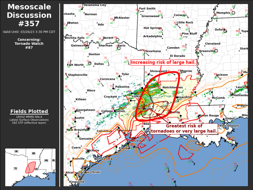
SUMMARY...Storms including supercells are expected to develop along
a boundary from southeast Texas into Louisiana. Large hail can be
expected, aside from damaging winds and an increasing tornado risk.
The tornado watch area is approximately along and 50 statute miles
north and south of a line from 40 miles east northeast of Alexandria
LA to 55 miles south southwest of Lufkin TX. For a complete
depiction of the watch see the associated watch outline update
(WOUS64 KWNS WOU7).
PRECAUTIONARY/PREPAREDNESS ACTIONS...
REMEMBER...A Tornado Watch means conditions are favorable for
tornadoes and severe thunderstorms in and close to the watch
area. Persons in these areas should be on the lookout for
threatening weather conditions and listen for later statements
and possible warnings.
&&
OTHER WATCH INFORMATION...CONTINUE...WW 86...
AVIATION...Tornadoes and a few severe thunderstorms with hail
surface and aloft to 2.5 inches. Extreme turbulence and surface wind
gusts to 60 knots. A few cumulonimbi with maximum tops to 550. Mean
storm motion vector 25030.
...Guyer
   SEL7

   URGENT - IMMEDIATE BROADCAST REQUESTED
   Tornado Watch Number 87
   NWS Storm Prediction Center Norman OK
   1245 PM CDT Sun Mar 26 2023

   The NWS Storm Prediction Center has issued a

   * Tornado Watch for portions of
     Louisiana
     Southeast Texas

   * Effective this Sunday afternoon and evening from 1245 PM until
     700 PM CDT.

   * Primary threats include...
     A few tornadoes and a couple intense tornadoes possible
     Scattered large hail likely with isolated very large hail events
       to 2.5 inches in diameter possible
     Scattered damaging wind gusts to 70 mph possible

   SUMMARY...Storms including supercells are expected to develop along
   a boundary from southeast Texas into Louisiana. Large hail can be
   expected, aside from damaging winds and an increasing tornado risk.

   The tornado watch area is approximately along and 50 statute miles
   north and south of a line from 40 miles east northeast of Alexandria
   LA to 55 miles south southwest of Lufkin TX. For a complete
   depiction of the watch see the associated watch outline update
   (WOUS64 KWNS WOU7).

   PRECAUTIONARY/PREPAREDNESS ACTIONS...

   REMEMBER...A Tornado Watch means conditions are favorable for
   tornadoes and severe thunderstorms in and close to the watch
   area. Persons in these areas should be on the lookout for
   threatening weather conditions and listen for later statements
   and possible warnings.

   &&

   OTHER WATCH INFORMATION...CONTINUE...WW 86...

   AVIATION...Tornadoes and a few severe thunderstorms with hail
   surface and aloft to 2.5 inches. Extreme turbulence and surface wind
   gusts to 60 knots. A few cumulonimbi with maximum tops to 550. Mean
   storm motion vector 25030.

   ...Guyer
 Note:
The Aviation Watch (SAW) product is an approximation to the watch area.
The actual watch is depicted by the shaded areas.
Note:
The Aviation Watch (SAW) product is an approximation to the watch area.
The actual watch is depicted by the shaded areas.
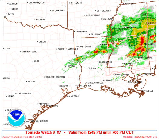
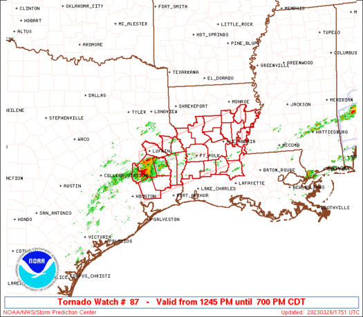
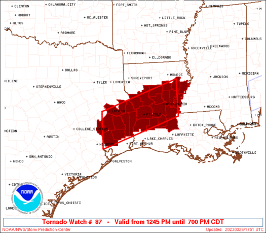
   SAW7
   WW 87 TORNADO LA TX 261745Z - 270000Z
   AXIS..50 STATUTE MILES NORTH AND SOUTH OF LINE..
   40ENE ESF/ALEXANDRIA LA/ - 55SSW LFK/LUFKIN TX/
   ..AVIATION COORDS.. 45NM N/S /48ENE AEX - 35NNE IAH/
   HAIL SURFACE AND ALOFT..2.5 INCHES. WIND GUSTS..60 KNOTS.
   MAX TOPS TO 550. MEAN STORM MOTION VECTOR 25030.

   LAT...LON 30909167 29779510 31229510 32349167

   THIS IS AN APPROXIMATION TO THE WATCH AREA.  FOR A
   COMPLETE DEPICTION OF THE WATCH SEE WOUS64 KWNS
   FOR WOU7.
Watch 87 Status Report Messages:
STATUS REPORT #5 ON WW 87

VALID 262250Z - 262340Z

SEVERE WEATHER THREAT CONTINUES RIGHT OF A LINE FROM 25 NE HOU TO
30 NE LFK.

FOR ADDITIONAL INFORMATION SEE MESOSCALE DISCUSSION 362

..THORNTON..03/26/23

ATTN...WFO...LCH...SHV...JAN...HGX...

&&

STATUS REPORT FOR WT 87

SEVERE WEATHER THREAT CONTINUES FOR THE FOLLOWING AREAS

LAC003-009-011-021-025-029-039-041-043-059-069-079-085-097-107-
115-127-262340-

LA
.    LOUISIANA PARISHES INCLUDED ARE

ALLEN		     AVOYELLES		 BEAUREGARD
CALDWELL	     CATAHOULA		 CONCORDIA
EVANGELINE	     FRANKLIN		 GRANT
LA SALLE	     NATCHITOCHES	 RAPIDES
SABINE		     ST. LANDRY 	 TENSAS
VERNON		     WINN
$$


TXC005-199-241-351-403-405-457-262340-

TX
.    TEXAS COUNTIES INCLUDED ARE

ANGELINA	     HARDIN		 JASPER
NEWTON		     SABINE		 SAN AUGUSTINE
TYLER
$$


THE WATCH STATUS MESSAGE IS FOR GUIDANCE PURPOSES ONLY.  PLEASE
REFER TO WATCH COUNTY NOTIFICATION STATEMENTS FOR OFFICIAL
INFORMATION ON COUNTIES...INDEPENDENT CITIES AND MARINE ZONES
CLEARED FROM SEVERE THUNDERSTORM AND TORNADO WATCHES.
$$

STATUS REPORT #4 ON WW 87

VALID 262135Z - 262240Z

THE SEVERE WEATHER THREAT CONTINUES ACROSS THE ENTIRE WATCH AREA.

..THORNTON..03/26/23

ATTN...WFO...LCH...SHV...JAN...HGX...

&&

STATUS REPORT FOR WT 87

SEVERE WEATHER THREAT CONTINUES FOR THE FOLLOWING AREAS

LAC003-009-011-021-025-029-039-041-043-059-069-079-085-097-107-
115-127-262240-

LA
.    LOUISIANA PARISHES INCLUDED ARE

ALLEN		     AVOYELLES		 BEAUREGARD
CALDWELL	     CATAHOULA		 CONCORDIA
EVANGELINE	     FRANKLIN		 GRANT
LA SALLE	     NATCHITOCHES	 RAPIDES
SABINE		     ST. LANDRY 	 TENSAS
VERNON		     WINN
$$


TXC005-199-241-291-351-373-403-405-407-457-262240-

TX
.    TEXAS COUNTIES INCLUDED ARE

ANGELINA	     HARDIN		 JASPER
LIBERTY 	     NEWTON		 POLK
SABINE		     SAN AUGUSTINE	 SAN JACINTO
TYLER
$$


THE WATCH STATUS MESSAGE IS FOR GUIDANCE PURPOSES ONLY.  PLEASE
REFER TO WATCH COUNTY NOTIFICATION STATEMENTS FOR OFFICIAL
INFORMATION ON COUNTIES...INDEPENDENT CITIES AND MARINE ZONES
CLEARED FROM SEVERE THUNDERSTORM AND TORNADO WATCHES.
$$

STATUS REPORT #3 ON WW 87

VALID 262035Z - 262140Z

THE SEVERE WEATHER THREAT CONTINUES ACROSS THE ENTIRE WATCH AREA.

FOR ADDITIONAL INFORMATION SEE MESOSCALE DISCUSSION 357

..THORNTON..03/26/23

ATTN...WFO...LCH...SHV...JAN...HGX...

&&

STATUS REPORT FOR WT 87

SEVERE WEATHER THREAT CONTINUES FOR THE FOLLOWING AREAS

LAC003-009-011-021-025-029-039-041-043-059-069-079-085-097-107-
115-127-262140-

LA
.    LOUISIANA PARISHES INCLUDED ARE

ALLEN		     AVOYELLES		 BEAUREGARD
CALDWELL	     CATAHOULA		 CONCORDIA
EVANGELINE	     FRANKLIN		 GRANT
LA SALLE	     NATCHITOCHES	 RAPIDES
SABINE		     ST. LANDRY 	 TENSAS
VERNON		     WINN
$$


TXC005-199-241-291-351-373-403-405-407-457-262140-

TX
.    TEXAS COUNTIES INCLUDED ARE

ANGELINA	     HARDIN		 JASPER
LIBERTY 	     NEWTON		 POLK
SABINE		     SAN AUGUSTINE	 SAN JACINTO
TYLER
$$


THE WATCH STATUS MESSAGE IS FOR GUIDANCE PURPOSES ONLY.  PLEASE
REFER TO WATCH COUNTY NOTIFICATION STATEMENTS FOR OFFICIAL
INFORMATION ON COUNTIES...INDEPENDENT CITIES AND MARINE ZONES
CLEARED FROM SEVERE THUNDERSTORM AND TORNADO WATCHES.
$$

STATUS REPORT #2 ON WW 87

VALID 261935Z - 262040Z

THE SEVERE WEATHER THREAT CONTINUES ACROSS THE ENTIRE WATCH AREA.

FOR ADDITIONAL INFORMATION SEE MESOSCALE DISCUSSION 357

..THORNTON..03/26/23

ATTN...WFO...LCH...SHV...JAN...HGX...

&&

STATUS REPORT FOR WT 87

SEVERE WEATHER THREAT CONTINUES FOR THE FOLLOWING AREAS

LAC003-009-011-021-025-029-039-041-043-059-069-079-085-097-107-
115-127-262040-

LA
.    LOUISIANA PARISHES INCLUDED ARE

ALLEN		     AVOYELLES		 BEAUREGARD
CALDWELL	     CATAHOULA		 CONCORDIA
EVANGELINE	     FRANKLIN		 GRANT
LA SALLE	     NATCHITOCHES	 RAPIDES
SABINE		     ST. LANDRY 	 TENSAS
VERNON		     WINN
$$


TXC005-199-241-291-351-373-403-405-407-457-262040-

TX
.    TEXAS COUNTIES INCLUDED ARE

ANGELINA	     HARDIN		 JASPER
LIBERTY 	     NEWTON		 POLK
SABINE		     SAN AUGUSTINE	 SAN JACINTO
TYLER
$$


THE WATCH STATUS MESSAGE IS FOR GUIDANCE PURPOSES ONLY.  PLEASE
REFER TO WATCH COUNTY NOTIFICATION STATEMENTS FOR OFFICIAL
INFORMATION ON COUNTIES...INDEPENDENT CITIES AND MARINE ZONES
CLEARED FROM SEVERE THUNDERSTORM AND TORNADO WATCHES.
$$

STATUS REPORT #1 ON WW 87

VALID 261835Z - 261940Z

THE SEVERE WEATHER THREAT CONTINUES ACROSS THE ENTIRE WATCH AREA.

..THORNTON..03/26/23

ATTN...WFO...LCH...SHV...JAN...HGX...

&&

STATUS REPORT FOR WT 87

SEVERE WEATHER THREAT CONTINUES FOR THE FOLLOWING AREAS

LAC003-009-011-021-025-029-039-041-043-059-069-079-085-097-107-
115-127-261940-

LA
.    LOUISIANA PARISHES INCLUDED ARE

ALLEN		     AVOYELLES		 BEAUREGARD
CALDWELL	     CATAHOULA		 CONCORDIA
EVANGELINE	     FRANKLIN		 GRANT
LA SALLE	     NATCHITOCHES	 RAPIDES
SABINE		     ST. LANDRY 	 TENSAS
VERNON		     WINN
$$


TXC005-199-241-291-351-373-403-405-407-457-261940-

TX
.    TEXAS COUNTIES INCLUDED ARE

ANGELINA	     HARDIN		 JASPER
LIBERTY 	     NEWTON		 POLK
SABINE		     SAN AUGUSTINE	 SAN JACINTO
TYLER
$$


THE WATCH STATUS MESSAGE IS FOR GUIDANCE PURPOSES ONLY.  PLEASE
REFER TO WATCH COUNTY NOTIFICATION STATEMENTS FOR OFFICIAL
INFORMATION ON COUNTIES...INDEPENDENT CITIES AND MARINE ZONES
CLEARED FROM SEVERE THUNDERSTORM AND TORNADO WATCHES.
$$
Note:
Click for Complete Product Text.
Tornadoes
Probability of 2 or more tornadoes
|
Mod (50%)
|
Probability of 1 or more strong (EF2-EF5) tornadoes
|
Mod (30%)
|
Wind
Probability of 10 or more severe wind events
|
Mod (40%)
|
Probability of 1 or more wind events > 65 knots
|
Low (10%)
|
Hail
Probability of 10 or more severe hail events
|
High (70%)
|
Probability of 1 or more hailstones > 2 inches
|
Mod (50%)
|
Combined Severe Hail/Wind
Probability of 6 or more combined severe hail/wind events
|
High (90%)
|
For each watch, probabilities for particular events inside the watch
(listed above in each table) are determined by the issuing forecaster.
The "Low" category contains probability values ranging from less than 2%
to 20% (EF2-EF5 tornadoes), less than 5% to 20% (all other probabilities),
"Moderate" from 30% to 60%, and "High" from 70% to greater than 95%.
High values are bolded and lighter in color to provide awareness of
an increased threat for a particular event.


 @NWSSPC