Note:
The expiration time in the watch graphic is amended if the watch is
replaced, cancelled or extended.
Note:
Note:
The expiration time in the watch graphic is amended if the watch is
replaced, cancelled or extended.
Note: Click for
Watch Status Reports.
SEL5
URGENT - IMMEDIATE BROADCAST REQUESTED
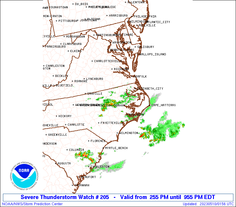
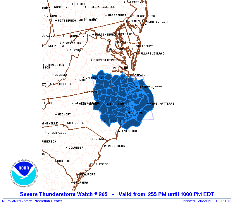
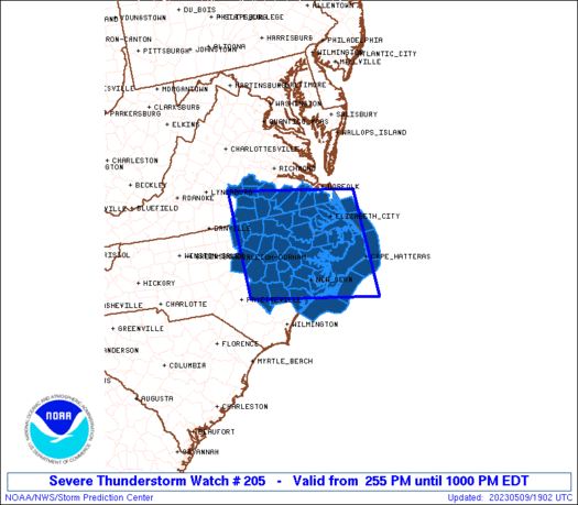
Severe Thunderstorm Watch Number 205
NWS Storm Prediction Center Norman OK
255 PM EDT Tue May 9 2023
The NWS Storm Prediction Center has issued a
* Severe Thunderstorm Watch for portions of
Eastern North Carolina
Southern Virginia
Coastal Waters
* Effective this Tuesday afternoon and evening from 255 PM until
1000 PM EDT.
* Primary threats include...
Scattered large hail and isolated very large hail events to 2
inches in diameter possible
Scattered damaging wind gusts to 65 mph possible
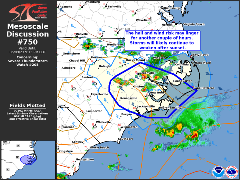
SUMMARY...Storms will continue to develop and increase across the
region, resulting in a few supercells and organized storm clusters,
which will be capable of large hail and damaging winds.
The severe thunderstorm watch area is approximately along and 80
statute miles north and south of a line from 45 miles west northwest
of Rocky Mount NC to 25 miles north northeast of Cape Hatteras NC.
For a complete depiction of the watch see the associated watch
outline update (WOUS64 KWNS WOU5).
PRECAUTIONARY/PREPAREDNESS ACTIONS...
REMEMBER...A Severe Thunderstorm Watch means conditions are
favorable for severe thunderstorms in and close to the watch area.
Persons in these areas should be on the lookout for threatening
weather conditions and listen for later statements and possible
warnings. Severe thunderstorms can and occasionally do produce
tornadoes.
&&
OTHER WATCH INFORMATION...CONTINUE...WW 204...
AVIATION...A few severe thunderstorms with hail surface and aloft to
2 inches. Extreme turbulence and surface wind gusts to 55 knots. A
few cumulonimbi with maximum tops to 500. Mean storm motion vector
29025.
...Guyer
   SEL5

   URGENT - IMMEDIATE BROADCAST REQUESTED
   Severe Thunderstorm Watch Number 205
   NWS Storm Prediction Center Norman OK
   255 PM EDT Tue May 9 2023

   The NWS Storm Prediction Center has issued a

   * Severe Thunderstorm Watch for portions of
     Eastern North Carolina
     Southern Virginia
     Coastal Waters

   * Effective this Tuesday afternoon and evening from 255 PM until
     1000 PM EDT.

   * Primary threats include...
     Scattered large hail and isolated very large hail events to 2
       inches in diameter possible
     Scattered damaging wind gusts to 65 mph possible

   SUMMARY...Storms will continue to develop and increase across the
   region, resulting in a few supercells and organized storm clusters,
   which will be capable of large hail and damaging winds.

   The severe thunderstorm watch area is approximately along and 80
   statute miles north and south of a line from 45 miles west northwest
   of Rocky Mount NC to 25 miles north northeast of Cape Hatteras NC.
   For a complete depiction of the watch see the associated watch
   outline update (WOUS64 KWNS WOU5).

   PRECAUTIONARY/PREPAREDNESS ACTIONS...

   REMEMBER...A Severe Thunderstorm Watch means conditions are
   favorable for severe thunderstorms in and close to the watch area.
   Persons in these areas should be on the lookout for threatening
   weather conditions and listen for later statements and possible
   warnings. Severe thunderstorms can and occasionally do produce
   tornadoes.

   &&

   OTHER WATCH INFORMATION...CONTINUE...WW 204...

   AVIATION...A few severe thunderstorms with hail surface and aloft to
   2 inches. Extreme turbulence and surface wind gusts to 55 knots. A
   few cumulonimbi with maximum tops to 500. Mean storm motion vector
   29025.

   ...Guyer
 Note:
The Aviation Watch (SAW) product is an approximation to the watch area.
The actual watch is depicted by the shaded areas.
Note:
The Aviation Watch (SAW) product is an approximation to the watch area.
The actual watch is depicted by the shaded areas.
   SAW5
   WW 205 SEVERE TSTM NC VA CW 091855Z - 100200Z
   AXIS..80 STATUTE MILES NORTH AND SOUTH OF LINE..
   45WNW RWI/ROCKY MOUNT NC/ - 25NNE HSE/CAPE HATTERAS NC/
   ..AVIATION COORDS.. 70NM N/S /15NNE RDU - 55SE ECG/
   HAIL SURFACE AND ALOFT..2 INCHES. WIND GUSTS..55 KNOTS.
   MAX TOPS TO 500. MEAN STORM MOTION VECTOR 29025.

   LAT...LON 37257864 36717544 34407544 34937864

   THIS IS AN APPROXIMATION TO THE WATCH AREA.  FOR A
   COMPLETE DEPICTION OF THE WATCH SEE WOUS64 KWNS
   FOR WOU5.
Watch 205 Status Report Messages:
STATUS REPORT #5 ON WW 205

VALID 092335Z - 100040Z

SEVERE WEATHER THREAT CONTINUES RIGHT OF A LINE FROM 20 NNW RDU
TO 20 SSE RZZ TO 40 SE RZZ TO 45 SSW ECG TO 50 SSE HSE.

..THORNTON..05/09/23

ATTN...WFO...MHX...AKQ...RAH...

&&

STATUS REPORT FOR WS 205

SEVERE WEATHER THREAT CONTINUES FOR THE FOLLOWING AREAS

NCC013-031-049-061-065-069-079-101-103-107-117-127-133-137-147-
163-183-191-195-100040-

NC
.    NORTH CAROLINA COUNTIES INCLUDED ARE

BEAUFORT	     CARTERET		 CRAVEN
DUPLIN		     EDGECOMBE		 FRANKLIN
GREENE		     JOHNSTON		 JONES
LENOIR		     MARTIN		 NASH
ONSLOW		     PAMLICO		 PITT
SAMPSON 	     WAKE		 WAYNE
WILSON
$$


AMZ136-137-156-158-100040-

CW

.    ADJACENT COASTAL WATERS INCLUDED ARE

PAMLICO AND PUNGO RIVERS

NEUSE AND BAY RIVERS

S OF OCRACOKE INLET NC TO CAPE LOOKOUT NC OUT TO 20 NM

S OF CAPE LOOKOUT NC TO SURF CITY NC OUT TO 20 NM

$$
THE WATCH STATUS MESSAGE IS FOR GUIDANCE PURPOSES ONLY.  PLEASE
REFER TO WATCH COUNTY NOTIFICATION STATEMENTS FOR OFFICIAL
INFORMATION ON COUNTIES...INDEPENDENT CITIES AND MARINE ZONES
CLEARED FROM SEVERE THUNDERSTORM AND TORNADO WATCHES.
$$

STATUS REPORT #4 ON WW 205

VALID 092250Z - 092340Z

SEVERE WEATHER THREAT CONTINUES RIGHT OF A LINE FROM 35 WNW AVC
TO 40 E RZZ TO 30 WSW ECG TO 50 NE HSE.

..THORNTON..05/09/23

ATTN...WFO...MHX...AKQ...RAH...

&&

STATUS REPORT FOR WS 205

SEVERE WEATHER THREAT CONTINUES FOR THE FOLLOWING AREAS

NCC013-015-031-049-055-061-065-069-077-079-083-091-095-101-103-
107-117-127-131-133-137-147-163-177-181-183-185-187-191-195-
092340-

NC
.    NORTH CAROLINA COUNTIES INCLUDED ARE

BEAUFORT	     BERTIE		 CARTERET
CRAVEN		     DARE		 DUPLIN
EDGECOMBE	     FRANKLIN		 GRANVILLE
GREENE		     HALIFAX		 HERTFORD
HYDE		     JOHNSTON		 JONES
LENOIR		     MARTIN		 NASH
NORTHAMPTON	     ONSLOW		 PAMLICO
PITT		     SAMPSON		 TYRRELL
VANCE		     WAKE		 WARREN
WASHINGTON	     WAYNE		 WILSON
$$


VAC117-092340-

VA
.    VIRGINIA COUNTIES INCLUDED ARE

MECKLENBURG
$$


AMZ131-135-136-137-152-154-156-158-092340-

CW

.    ADJACENT COASTAL WATERS INCLUDED ARE

ALLIGATOR RIVER

PAMLICO SOUND

PAMLICO AND PUNGO RIVERS

NEUSE AND BAY RIVERS

S OF OREGON INLET NC TO CAPE HATTERAS NC OUT TO 20 NM

S OF CAPE HATTERAS NC TO OCRACOKE INLET NC OUT TO 20 NM

S OF OCRACOKE INLET NC TO CAPE LOOKOUT NC OUT TO 20 NM

S OF CAPE LOOKOUT NC TO SURF CITY NC OUT TO 20 NM

$$
THE WATCH STATUS MESSAGE IS FOR GUIDANCE PURPOSES ONLY.  PLEASE
REFER TO WATCH COUNTY NOTIFICATION STATEMENTS FOR OFFICIAL
INFORMATION ON COUNTIES...INDEPENDENT CITIES AND MARINE ZONES
CLEARED FROM SEVERE THUNDERSTORM AND TORNADO WATCHES.
$$

STATUS REPORT #3 ON WW 205

VALID 092200Z - 092340Z

SEVERE WEATHER THREAT CONTINUES RIGHT OF A LINE FROM 35 WNW AVC
TO 30 NE RZZ TO 45 ENE ECG.

..THORNTON..05/09/23

ATTN...WFO...MHX...AKQ...RAH...

&&

STATUS REPORT FOR WS 205

SEVERE WEATHER THREAT CONTINUES FOR THE FOLLOWING AREAS

NCC013-015-029-031-041-049-053-055-061-065-069-073-077-079-083-
091-095-101-103-107-117-127-131-133-137-139-143-147-163-177-181-
183-185-187-191-195-092340-

NC
.    NORTH CAROLINA COUNTIES INCLUDED ARE

BEAUFORT	     BERTIE		 CAMDEN
CARTERET	     CHOWAN		 CRAVEN
CURRITUCK	     DARE		 DUPLIN
EDGECOMBE	     FRANKLIN		 GATES
GRANVILLE	     GREENE		 HALIFAX
HERTFORD	     HYDE		 JOHNSTON
JONES		     LENOIR		 MARTIN
NASH		     NORTHAMPTON	 ONSLOW
PAMLICO 	     PASQUOTANK 	 PERQUIMANS
PITT		     SAMPSON		 TYRRELL
VANCE		     WAKE		 WARREN
WASHINGTON	     WAYNE		 WILSON
$$


VAC025-081-117-595-092340-

VA
.    VIRGINIA COUNTIES INCLUDED ARE

BRUNSWICK	     GREENSVILLE	 MECKLENBURG


VIRGINIA INDEPENDENT CITIES INCLUDED ARE

EMPORIA
$$


AMZ131-135-136-137-150-152-154-156-158-230-231-ANZ633-658-
092340-

CW

.    ADJACENT COASTAL WATERS INCLUDED ARE

ALLIGATOR RIVER

PAMLICO SOUND

PAMLICO AND PUNGO RIVERS

NEUSE AND BAY RIVERS

S OF CURRITUCK BEACH LIGHT NC TO OREGON INLET NC OUT TO 20 NM

S OF OREGON INLET NC TO CAPE HATTERAS NC OUT TO 20 NM

S OF CAPE HATTERAS NC TO OCRACOKE INLET NC OUT TO 20 NM

S OF OCRACOKE INLET NC TO CAPE LOOKOUT NC OUT TO 20 NM

S OF CAPE LOOKOUT NC TO SURF CITY NC OUT TO 20 NM

ALBEMARLE SOUND

CROATAN AND ROANOKE SOUNDS

CURRITUCK SOUND

COASTAL WATERS FROM NC VA BORDER TO CURRITUCK BEACH LIGHT NC OUT
20 NM

$$
THE WATCH STATUS MESSAGE IS FOR GUIDANCE PURPOSES ONLY.  PLEASE
REFER TO WATCH COUNTY NOTIFICATION STATEMENTS FOR OFFICIAL
INFORMATION ON COUNTIES...INDEPENDENT CITIES AND MARINE ZONES
CLEARED FROM SEVERE THUNDERSTORM AND TORNADO WATCHES.
$$

STATUS REPORT #2 ON WW 205

VALID 092050Z - 092140Z

THE SEVERE WEATHER THREAT CONTINUES ACROSS THE ENTIRE WATCH AREA.

..THORNTON..05/09/23

ATTN...WFO...MHX...AKQ...RAH...

&&

STATUS REPORT FOR WS 205

SEVERE WEATHER THREAT CONTINUES FOR THE FOLLOWING AREAS

NCC013-015-029-031-041-049-053-055-061-065-069-073-077-079-083-
091-095-101-103-107-117-127-131-133-137-139-143-147-163-177-181-
183-185-187-191-195-092140-

NC
.    NORTH CAROLINA COUNTIES INCLUDED ARE

BEAUFORT	     BERTIE		 CAMDEN
CARTERET	     CHOWAN		 CRAVEN
CURRITUCK	     DARE		 DUPLIN
EDGECOMBE	     FRANKLIN		 GATES
GRANVILLE	     GREENE		 HALIFAX
HERTFORD	     HYDE		 JOHNSTON
JONES		     LENOIR		 MARTIN
NASH		     NORTHAMPTON	 ONSLOW
PAMLICO 	     PASQUOTANK 	 PERQUIMANS
PITT		     SAMPSON		 TYRRELL
VANCE		     WAKE		 WARREN
WASHINGTON	     WAYNE		 WILSON
$$


VAC007-025-053-081-093-111-117-135-147-175-183-550-595-620-800-
092140-

VA
.    VIRGINIA COUNTIES INCLUDED ARE

AMELIA		     BRUNSWICK		 DINWIDDIE
GREENSVILLE	     ISLE OF WIGHT	 LUNENBURG
MECKLENBURG	     NOTTOWAY		 PRINCE EDWARD
SOUTHAMPTON	     SUSSEX


VIRGINIA INDEPENDENT CITIES INCLUDED ARE

CHESAPEAKE	     EMPORIA		 FRANKLIN
SUFFOLK
$$


AMZ131-135-136-137-150-152-154-156-158-230-231-ANZ633-658-
092140-

CW

.    ADJACENT COASTAL WATERS INCLUDED ARE

ALLIGATOR RIVER

PAMLICO SOUND

PAMLICO AND PUNGO RIVERS

NEUSE AND BAY RIVERS

S OF CURRITUCK BEACH LIGHT NC TO OREGON INLET NC OUT TO 20 NM

S OF OREGON INLET NC TO CAPE HATTERAS NC OUT TO 20 NM

S OF CAPE HATTERAS NC TO OCRACOKE INLET NC OUT TO 20 NM

S OF OCRACOKE INLET NC TO CAPE LOOKOUT NC OUT TO 20 NM

S OF CAPE LOOKOUT NC TO SURF CITY NC OUT TO 20 NM

ALBEMARLE SOUND

CROATAN AND ROANOKE SOUNDS

CURRITUCK SOUND

COASTAL WATERS FROM NC VA BORDER TO CURRITUCK BEACH LIGHT NC OUT
20 NM

$$
THE WATCH STATUS MESSAGE IS FOR GUIDANCE PURPOSES ONLY.  PLEASE
REFER TO WATCH COUNTY NOTIFICATION STATEMENTS FOR OFFICIAL
INFORMATION ON COUNTIES...INDEPENDENT CITIES AND MARINE ZONES
CLEARED FROM SEVERE THUNDERSTORM AND TORNADO WATCHES.
$$

STATUS REPORT #1 ON WW 205

VALID 091940Z - 092040Z

THE SEVERE WEATHER THREAT CONTINUES ACROSS THE ENTIRE WATCH AREA.

..THORNTON..05/09/23

ATTN...WFO...MHX...AKQ...RAH...

&&

STATUS REPORT FOR WS 205

SEVERE WEATHER THREAT CONTINUES FOR THE FOLLOWING AREAS

NCC013-015-029-031-041-049-053-055-061-065-069-073-077-079-083-
091-095-101-103-107-117-127-131-133-137-139-143-147-163-177-181-
183-185-187-191-195-092040-

NC
.    NORTH CAROLINA COUNTIES INCLUDED ARE

BEAUFORT	     BERTIE		 CAMDEN
CARTERET	     CHOWAN		 CRAVEN
CURRITUCK	     DARE		 DUPLIN
EDGECOMBE	     FRANKLIN		 GATES
GRANVILLE	     GREENE		 HALIFAX
HERTFORD	     HYDE		 JOHNSTON
JONES		     LENOIR		 MARTIN
NASH		     NORTHAMPTON	 ONSLOW
PAMLICO 	     PASQUOTANK 	 PERQUIMANS
PITT		     SAMPSON		 TYRRELL
VANCE		     WAKE		 WARREN
WASHINGTON	     WAYNE		 WILSON
$$


VAC007-025-053-081-093-111-117-135-147-175-183-550-595-620-800-
092040-

VA
.    VIRGINIA COUNTIES INCLUDED ARE

AMELIA		     BRUNSWICK		 DINWIDDIE
GREENSVILLE	     ISLE OF WIGHT	 LUNENBURG
MECKLENBURG	     NOTTOWAY		 PRINCE EDWARD
SOUTHAMPTON	     SUSSEX


VIRGINIA INDEPENDENT CITIES INCLUDED ARE

CHESAPEAKE	     EMPORIA		 FRANKLIN
SUFFOLK
$$


AMZ131-135-136-137-150-152-154-156-158-230-231-ANZ633-658-
092040-

CW

.    ADJACENT COASTAL WATERS INCLUDED ARE

ALLIGATOR RIVER

PAMLICO SOUND

PAMLICO AND PUNGO RIVERS

NEUSE AND BAY RIVERS

S OF CURRITUCK BEACH LIGHT NC TO OREGON INLET NC OUT TO 20 NM

S OF OREGON INLET NC TO CAPE HATTERAS NC OUT TO 20 NM

S OF CAPE HATTERAS NC TO OCRACOKE INLET NC OUT TO 20 NM

S OF OCRACOKE INLET NC TO CAPE LOOKOUT NC OUT TO 20 NM

S OF CAPE LOOKOUT NC TO SURF CITY NC OUT TO 20 NM

ALBEMARLE SOUND

CROATAN AND ROANOKE SOUNDS

CURRITUCK SOUND

COASTAL WATERS FROM NC VA BORDER TO CURRITUCK BEACH LIGHT NC OUT
20 NM

$$
THE WATCH STATUS MESSAGE IS FOR GUIDANCE PURPOSES ONLY.  PLEASE
REFER TO WATCH COUNTY NOTIFICATION STATEMENTS FOR OFFICIAL
INFORMATION ON COUNTIES...INDEPENDENT CITIES AND MARINE ZONES
CLEARED FROM SEVERE THUNDERSTORM AND TORNADO WATCHES.
$$
Note:
Click for Complete Product Text.
Tornadoes
Probability of 2 or more tornadoes
|
Low (10%)
|
Probability of 1 or more strong (EF2-EF5) tornadoes
|
Low (5%)
|
Wind
Probability of 10 or more severe wind events
|
Mod (50%)
|
Probability of 1 or more wind events > 65 knots
|
Low (10%)
|
Hail
Probability of 10 or more severe hail events
|
Mod (40%)
|
Probability of 1 or more hailstones > 2 inches
|
Mod (30%)
|
Combined Severe Hail/Wind
Probability of 6 or more combined severe hail/wind events
|
High (80%)
|
For each watch, probabilities for particular events inside the watch
(listed above in each table) are determined by the issuing forecaster.
The "Low" category contains probability values ranging from less than 2%
to 20% (EF2-EF5 tornadoes), less than 5% to 20% (all other probabilities),
"Moderate" from 30% to 60%, and "High" from 70% to greater than 95%.
High values are bolded and lighter in color to provide awareness of
an increased threat for a particular event.


 @NWSSPC