 Note:
The expiration time in the watch graphic is amended if the watch is
replaced, cancelled or extended.
Note:
Note:
The expiration time in the watch graphic is amended if the watch is
replaced, cancelled or extended.
Note: Click for
Watch Status Reports.
SEL9
URGENT - IMMEDIATE BROADCAST REQUESTED
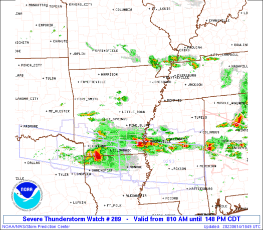
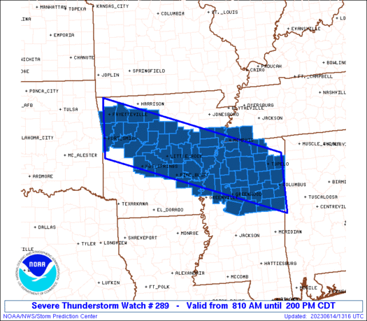
Severe Thunderstorm Watch Number 289
NWS Storm Prediction Center Norman OK
810 AM CDT Wed Jun 14 2023
The NWS Storm Prediction Center has issued a
* Severe Thunderstorm Watch for portions of
Arkansas
Northern Mississippi
Southwest Tennessee
* Effective this Wednesday morning and afternoon from 810 AM
until 200 PM CDT.
* Primary threats include...
Scattered large hail likely with isolated very large hail events
to 2 inches in diameter possible
Scattered damaging wind gusts to 70 mph possible
SUMMARY...Multiple clusters are likely to persist and intensify
across the region through the morning into afternoon.
The severe thunderstorm watch area is approximately along and 60
statute miles north and south of a line from 20 miles north of Fort
Smith AR to 10 miles east northeast of Columbus MS. For a complete
depiction of the watch see the associated watch outline update
(WOUS64 KWNS WOU9).
PRECAUTIONARY/PREPAREDNESS ACTIONS...
REMEMBER...A Severe Thunderstorm Watch means conditions are
favorable for severe thunderstorms in and close to the watch area.
Persons in these areas should be on the lookout for threatening
weather conditions and listen for later statements and possible
warnings. Severe thunderstorms can and occasionally do produce
tornadoes.
&&
OTHER WATCH INFORMATION...CONTINUE...WW 288...
AVIATION...A few severe thunderstorms with hail surface and aloft to
2 inches. Extreme turbulence and surface wind gusts to 60 knots. A
few cumulonimbi with maximum tops to 550. Mean storm motion vector
28025.
...Guyer
 Note:
The Aviation Watch (SAW) product is an approximation to the watch area.
The actual watch is depicted by the shaded areas.
Note:
The Aviation Watch (SAW) product is an approximation to the watch area.
The actual watch is depicted by the shaded areas.
   SAW9
   WW 289 SEVERE TSTM AR MS TN 141310Z - 141900Z
   AXIS..60 STATUTE MILES NORTH AND SOUTH OF LINE..
   20N FSM/FORT SMITH AR/ - 10ENE CBM/COLUMBUS MS/
   ..AVIATION COORDS.. 50NM N/S /15NNW FSM - 17NE IGB/
   HAIL SURFACE AND ALOFT..2 INCHES. WIND GUSTS..60 KNOTS.
   MAX TOPS TO 550. MEAN STORM MOTION VECTOR 28025.

   LAT...LON 36499437 34558829 32828829 34759437

   THIS IS AN APPROXIMATION TO THE WATCH AREA.  FOR A
   COMPLETE DEPICTION OF THE WATCH SEE WOUS64 KWNS
   FOR WOU9.
Watch 289 Status Report Messages:
STATUS REPORT #5 ON WW 289

VALID 141845Z - 141940Z

SEVERE WEATHER THREAT CONTINUES RIGHT OF A LINE FROM 25 NNW GLH
TO 45 SSE UOX TO 20 ENE CBM.

..LYONS..06/14/23

ATTN...WFO...LZK...TSA...MEG...JAN...

&&

STATUS REPORT FOR WS 289

SEVERE WEATHER THREAT CONTINUES FOR THE FOLLOWING AREAS

MSC007-015-019-025-051-083-087-097-103-105-133-155-159-141940-

MS
.    MISSISSIPPI COUNTIES INCLUDED ARE

ATTALA		     CARROLL		 CHOCTAW
CLAY		     HOLMES		 LEFLORE
LOWNDES 	     MONTGOMERY 	 NOXUBEE
OKTIBBEHA	     SUNFLOWER		 WEBSTER
WINSTON
$$


THE WATCH STATUS MESSAGE IS FOR GUIDANCE PURPOSES ONLY.  PLEASE
REFER TO WATCH COUNTY NOTIFICATION STATEMENTS FOR OFFICIAL
INFORMATION ON COUNTIES...INDEPENDENT CITIES AND MARINE ZONES
CLEARED FROM SEVERE THUNDERSTORM AND TORNADO WATCHES.
$$

STATUS REPORT #4 ON WW 289

VALID 141740Z - 141840Z

SEVERE WEATHER THREAT CONTINUES RIGHT OF A LINE FROM 10 SW PBF TO
40 NNW GWO TO 30 SW TUP TO 25 E TUP TO 35 WSW MSL.

..LYONS..06/14/23

ATTN...WFO...LZK...TSA...MEG...JAN...

&&

STATUS REPORT FOR WS 289

SEVERE WEATHER THREAT CONTINUES FOR THE FOLLOWING AREAS

MSC007-011-015-019-025-043-051-083-087-097-103-105-133-155-159-
141840-

MS
.    MISSISSIPPI COUNTIES INCLUDED ARE

ATTALA		     BOLIVAR		 CARROLL
CHOCTAW 	     CLAY		 GRENADA
HOLMES		     LEFLORE		 LOWNDES
MONTGOMERY	     NOXUBEE		 OKTIBBEHA
SUNFLOWER	     WEBSTER		 WINSTON
$$


THE WATCH STATUS MESSAGE IS FOR GUIDANCE PURPOSES ONLY.  PLEASE
REFER TO WATCH COUNTY NOTIFICATION STATEMENTS FOR OFFICIAL
INFORMATION ON COUNTIES...INDEPENDENT CITIES AND MARINE ZONES
CLEARED FROM SEVERE THUNDERSTORM AND TORNADO WATCHES.
$$

STATUS REPORT #3 ON WW 289

VALID 141630Z - 141740Z

SEVERE WEATHER THREAT CONTINUES RIGHT OF A LINE FROM 25 W HOT TO
60 NE PBF TO 15 N MEM.

..SQUITIERI..06/14/23

ATTN...WFO...LZK...TSA...MEG...JAN...

&&

STATUS REPORT FOR WS 289

SEVERE WEATHER THREAT CONTINUES FOR THE FOLLOWING AREAS

ARC001-041-053-059-069-079-107-141740-

AR
.    ARKANSAS COUNTIES INCLUDED ARE

ARKANSAS	     DESHA		 GRANT
HOT SPRING	     JEFFERSON		 LINCOLN
PHILLIPS
$$


MSC007-009-011-013-015-017-019-025-027-033-043-051-057-071-081-
083-087-093-095-097-103-105-107-115-119-133-135-137-139-143-145-
155-159-161-141740-

MS
.    MISSISSIPPI COUNTIES INCLUDED ARE

ATTALA		     BENTON		 BOLIVAR
CALHOUN 	     CARROLL		 CHICKASAW
CHOCTAW 	     CLAY		 COAHOMA
DESOTO		     GRENADA		 HOLMES
ITAWAMBA	     LAFAYETTE		 LEE
LEFLORE 	     LOWNDES		 MARSHALL
MONROE		     MONTGOMERY 	 NOXUBEE
OKTIBBEHA	     PANOLA		 PONTOTOC
QUITMAN 	     SUNFLOWER		 TALLAHATCHIE
TATE		     TIPPAH		 TUNICA
UNION		     WEBSTER		 WINSTON
YALOBUSHA
$$


TNC047-157-141740-

TN
.    TENNESSEE COUNTIES INCLUDED ARE

FAYETTE 	     SHELBY
$$


THE WATCH STATUS MESSAGE IS FOR GUIDANCE PURPOSES ONLY.  PLEASE
REFER TO WATCH COUNTY NOTIFICATION STATEMENTS FOR OFFICIAL
INFORMATION ON COUNTIES...INDEPENDENT CITIES AND MARINE ZONES
CLEARED FROM SEVERE THUNDERSTORM AND TORNADO WATCHES.
$$

STATUS REPORT #2 ON WW 289

VALID 141540Z - 141640Z

SEVERE WEATHER THREAT CONTINUES RIGHT OF A LINE FROM 10 ENE RKR
TO 25 NNE RUE TO 10 SW FLP.

..SQUITIERI..06/14/23

ATTN...WFO...LZK...TSA...MEG...JAN...

&&

STATUS REPORT FOR WS 289

SEVERE WEATHER THREAT CONTINUES FOR THE FOLLOWING AREAS

ARC001-023-029-035-037-041-045-051-053-059-069-077-079-083-085-
095-105-107-115-117-119-123-125-129-141-145-147-149-141640-

AR
.    ARKANSAS COUNTIES INCLUDED ARE

ARKANSAS	     CLEBURNE		 CONWAY
CRITTENDEN	     CROSS		 DESHA
FAULKNER	     GARLAND		 GRANT
HOT SPRING	     JEFFERSON		 LEE
LINCOLN 	     LOGAN		 LONOKE
MONROE		     PERRY		 PHILLIPS
POPE		     PRAIRIE		 PULASKI
ST. FRANCIS	     SALINE		 SEARCY
VAN BUREN	     WHITE		 WOODRUFF
YELL
$$


MSC007-009-011-013-015-017-019-025-027-033-043-051-057-071-081-
083-087-093-095-097-103-105-107-115-119-133-135-137-139-143-145-
155-159-161-141640-

MS
.    MISSISSIPPI COUNTIES INCLUDED ARE

ATTALA		     BENTON		 BOLIVAR
CALHOUN 	     CARROLL		 CHICKASAW
CHOCTAW 	     CLAY		 COAHOMA
DESOTO		     GRENADA		 HOLMES
ITAWAMBA	     LAFAYETTE		 LEE
LEFLORE 	     LOWNDES		 MARSHALL
MONROE		     MONTGOMERY 	 NOXUBEE
OKTIBBEHA	     PANOLA		 PONTOTOC
QUITMAN 	     SUNFLOWER		 TALLAHATCHIE
TATE		     TIPPAH		 TUNICA
UNION		     WEBSTER		 WINSTON
YALOBUSHA
$$


TNC047-157-141640-

TN
.    TENNESSEE COUNTIES INCLUDED ARE

FAYETTE 	     SHELBY
$$


THE WATCH STATUS MESSAGE IS FOR GUIDANCE PURPOSES ONLY.  PLEASE
REFER TO WATCH COUNTY NOTIFICATION STATEMENTS FOR OFFICIAL
INFORMATION ON COUNTIES...INDEPENDENT CITIES AND MARINE ZONES
CLEARED FROM SEVERE THUNDERSTORM AND TORNADO WATCHES.
$$

STATUS REPORT #1 ON WW 289

VALID 141435Z - 141540Z

THE SEVERE WEATHER THREAT CONTINUES ACROSS THE ENTIRE WATCH AREA.

..SQUITIERI..06/14/23

ATTN...WFO...LZK...TSA...MEG...JAN...

&&

STATUS REPORT FOR WS 289

SEVERE WEATHER THREAT CONTINUES FOR THE FOLLOWING AREAS

ARC001-023-029-033-035-037-041-045-047-051-053-059-069-071-077-
079-083-085-087-095-101-105-107-115-117-119-123-125-129-131-141-
143-145-147-149-141540-

AR
.    ARKANSAS COUNTIES INCLUDED ARE

ARKANSAS	     CLEBURNE		 CONWAY
CRAWFORD	     CRITTENDEN 	 CROSS
DESHA		     FAULKNER		 FRANKLIN
GARLAND 	     GRANT		 HOT SPRING
JEFFERSON	     JOHNSON		 LEE
LINCOLN 	     LOGAN		 LONOKE
MADISON 	     MONROE		 NEWTON
PERRY		     PHILLIPS		 POPE
PRAIRIE 	     PULASKI		 ST. FRANCIS
SALINE		     SEARCY		 SEBASTIAN
VAN BUREN	     WASHINGTON 	 WHITE
WOODRUFF	     YELL
$$


MSC007-009-011-013-015-017-019-025-027-033-043-051-057-071-081-
083-087-093-095-097-103-105-107-115-119-133-135-137-139-143-145-
155-159-161-141540-

MS
.    MISSISSIPPI COUNTIES INCLUDED ARE

ATTALA		     BENTON		 BOLIVAR
CALHOUN 	     CARROLL		 CHICKASAW
CHOCTAW 	     CLAY		 COAHOMA
DESOTO		     GRENADA		 HOLMES
ITAWAMBA	     LAFAYETTE		 LEE
LEFLORE 	     LOWNDES		 MARSHALL
MONROE		     MONTGOMERY 	 NOXUBEE
OKTIBBEHA	     PANOLA		 PONTOTOC
QUITMAN 	     SUNFLOWER		 TALLAHATCHIE
TATE		     TIPPAH		 TUNICA
UNION		     WEBSTER		 WINSTON
YALOBUSHA
$$


TNC047-157-141540-

TN
.    TENNESSEE COUNTIES INCLUDED ARE

FAYETTE 	     SHELBY
$$


THE WATCH STATUS MESSAGE IS FOR GUIDANCE PURPOSES ONLY.  PLEASE
REFER TO WATCH COUNTY NOTIFICATION STATEMENTS FOR OFFICIAL
INFORMATION ON COUNTIES...INDEPENDENT CITIES AND MARINE ZONES
CLEARED FROM SEVERE THUNDERSTORM AND TORNADO WATCHES.
$$
Note:
Click for Complete Product Text.
Tornadoes
Probability of 2 or more tornadoes
|
Low (10%)
|
Probability of 1 or more strong (EF2-EF5) tornadoes
|
Low (5%)
|
Wind
Probability of 10 or more severe wind events
|
Mod (50%)
|
Probability of 1 or more wind events > 65 knots
|
Low (20%)
|
Hail
Probability of 10 or more severe hail events
|
Mod (60%)
|
Probability of 1 or more hailstones > 2 inches
|
Mod (50%)
|
Combined Severe Hail/Wind
Probability of 6 or more combined severe hail/wind events
|
High (90%)
|
For each watch, probabilities for particular events inside the watch
(listed above in each table) are determined by the issuing forecaster.
The "Low" category contains probability values ranging from less than 2%
to 20% (EF2-EF5 tornadoes), less than 5% to 20% (all other probabilities),
"Moderate" from 30% to 60%, and "High" from 70% to greater than 95%.
High values are bolded and lighter in color to provide awareness of
an increased threat for a particular event.


 @NWSSPC


