 Note:
The expiration time in the watch graphic is amended if the watch is
replaced, cancelled or extended.
Note:
Note:
The expiration time in the watch graphic is amended if the watch is
replaced, cancelled or extended.
Note: Click for
Watch Status Reports.
SEL0
URGENT - IMMEDIATE BROADCAST REQUESTED
Severe Thunderstorm Watch Number 290
NWS Storm Prediction Center Norman OK
855 AM CDT Wed Jun 14 2023
The NWS Storm Prediction Center has issued a
* Severe Thunderstorm Watch for portions of
Southwest Arkansas
Northwest and north central Louisiana
South central into southeast Oklahoma
North and northeast Texas
* Effective this Wednesday morning and afternoon from 855 AM
until 400 PM CDT.
* Primary threats include...
Widespread large hail and scattered very large hail events to 3
inches in diameter likely
Scattered damaging winds likely with isolated significant gusts
to 75 mph possible
A tornado or two possible
SUMMARY...Supercell development is expected this morning along and
just north of a stalled front close to the Red River, and the storms
will spread generally east-southeastward into this afternoon. The
storm environment favors very large hail (to at least 3 inches in
diameter) and a few damaging gusts of 60-75 mph. An isolated
tornado or two may also occur by early-mid afternoon with any
supercells right along the front across northeast Texas and
northwest Louisiana.
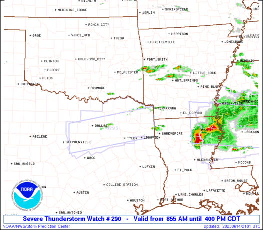
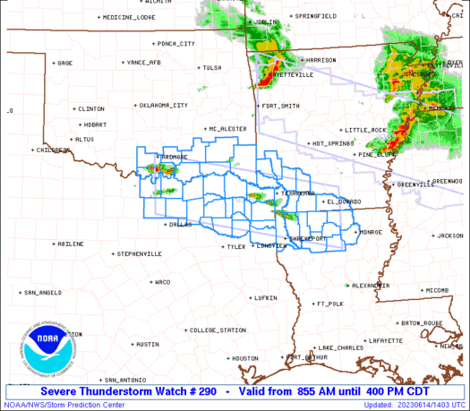
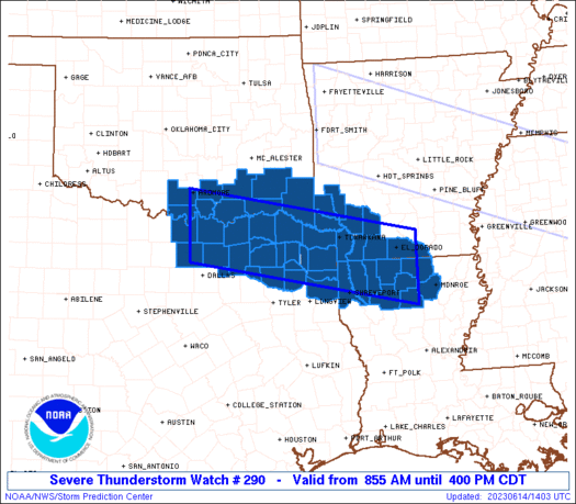
The severe thunderstorm watch area is approximately along and 45
statute miles north and south of a line from 25 miles west of
Sherman TX to 35 miles southeast of El Dorado AR. For a complete
depiction of the watch see the associated watch outline update
(WOUS64 KWNS WOU0).
PRECAUTIONARY/PREPAREDNESS ACTIONS...
REMEMBER...A Severe Thunderstorm Watch means conditions are
favorable for severe thunderstorms in and close to the watch area.
Persons in these areas should be on the lookout for threatening
weather conditions and listen for later statements and possible
warnings. Severe thunderstorms can and occasionally do produce
tornadoes.
&&
OTHER WATCH INFORMATION...CONTINUE...WW 289...
AVIATION...A few severe thunderstorms with hail surface and aloft to
3 inches. Extreme turbulence and surface wind gusts to 65 knots. A
few cumulonimbi with maximum tops to 600. Mean storm motion vector
28035.
...Thompson
   SEL0

   URGENT - IMMEDIATE BROADCAST REQUESTED
   Severe Thunderstorm Watch Number 290
   NWS Storm Prediction Center Norman OK
   855 AM CDT Wed Jun 14 2023

   The NWS Storm Prediction Center has issued a

   * Severe Thunderstorm Watch for portions of
     Southwest Arkansas
     Northwest and north central Louisiana
     South central into southeast Oklahoma
     North and northeast Texas

   * Effective this Wednesday morning and afternoon from 855 AM
     until 400 PM CDT.

   * Primary threats include...
     Widespread large hail and scattered very large hail events to 3
       inches in diameter likely
     Scattered damaging winds likely with isolated significant gusts
       to 75 mph possible
     A tornado or two possible

   SUMMARY...Supercell development is expected this morning along and
   just north of a stalled front close to the Red River, and the storms
   will spread generally east-southeastward into this afternoon.  The
   storm environment favors very large hail (to at least 3 inches in
   diameter) and a few damaging gusts of 60-75 mph.  An isolated
   tornado or two may also occur by early-mid afternoon with any
   supercells right along the front across northeast Texas and
   northwest Louisiana.

   The severe thunderstorm watch area is approximately along and 45
   statute miles north and south of a line from 25 miles west of
   Sherman TX to 35 miles southeast of El Dorado AR. For a complete
   depiction of the watch see the associated watch outline update
   (WOUS64 KWNS WOU0).

   PRECAUTIONARY/PREPAREDNESS ACTIONS...

   REMEMBER...A Severe Thunderstorm Watch means conditions are
   favorable for severe thunderstorms in and close to the watch area.
   Persons in these areas should be on the lookout for threatening
   weather conditions and listen for later statements and possible
   warnings. Severe thunderstorms can and occasionally do produce
   tornadoes.

   &&

   OTHER WATCH INFORMATION...CONTINUE...WW 289...

   AVIATION...A few severe thunderstorms with hail surface and aloft to
   3 inches. Extreme turbulence and surface wind gusts to 65 knots. A
   few cumulonimbi with maximum tops to 600. Mean storm motion vector
   28035.

   ...Thompson
 Note:
The Aviation Watch (SAW) product is an approximation to the watch area.
The actual watch is depicted by the shaded areas.
Note:
The Aviation Watch (SAW) product is an approximation to the watch area.
The actual watch is depicted by the shaded areas.
   SAW0
   WW 290 SEVERE TSTM AR LA OK TX 141355Z - 142100Z
   AXIS..45 STATUTE MILES NORTH AND SOUTH OF LINE..
   25W GYI/SHERMAN TX/ - 35SE ELD/EL DORADO AR/
   ..AVIATION COORDS.. 40NM N/S /30S ADM - 28NW MLU/
   HAIL SURFACE AND ALOFT..3 INCHES. WIND GUSTS..65 KNOTS.
   MAX TOPS TO 600. MEAN STORM MOTION VECTOR 28035.

   LAT...LON 34379711 33509239 32219239 33079711

   THIS IS AN APPROXIMATION TO THE WATCH AREA.  FOR A
   COMPLETE DEPICTION OF THE WATCH SEE WOUS64 KWNS
   FOR WOU0.
Watch 290 Status Report Messages:
STATUS REPORT #7 ON WW 290

VALID 142045Z - 142100Z

SEVERE WEATHER THREAT CONTINUES RIGHT OF A LINE FROM 40 E SHV TO
35 ESE ELD.

WW 290 WILL BE ALLOWED TO EXPIRE AT 142100Z.

..LYONS..06/14/23

ATTN...WFO...SHV...OUN...TSA...FWD...

&&

STATUS REPORT FOR WS 290

SEVERE WEATHER THREAT CONTINUES FOR THE FOLLOWING AREAS

LAC013-021-049-061-073-111-127-142100-

LA
.    LOUISIANA PARISHES INCLUDED ARE

BIENVILLE	     CALDWELL		 JACKSON
LINCOLN 	     OUACHITA		 UNION
WINN
$$


THE WATCH STATUS MESSAGE IS FOR GUIDANCE PURPOSES ONLY.  PLEASE
REFER TO WATCH COUNTY NOTIFICATION STATEMENTS FOR OFFICIAL
INFORMATION ON COUNTIES...INDEPENDENT CITIES AND MARINE ZONES
CLEARED FROM SEVERE THUNDERSTORM AND TORNADO WATCHES.
$$

STATUS REPORT #6 ON WW 290

VALID 141950Z - 142040Z

SEVERE WEATHER THREAT CONTINUES RIGHT OF A LINE FROM 30 NNE TYR
TO 25 W TXK TO 30 WNW ELD TO 25 NNE ELD.

..LYONS..06/14/23

ATTN...WFO...SHV...OUN...TSA...FWD...

&&

STATUS REPORT FOR WS 290

SEVERE WEATHER THREAT CONTINUES FOR THE FOLLOWING AREAS

ARC027-073-091-139-142040-

AR
.    ARKANSAS COUNTIES INCLUDED ARE

COLUMBIA	     LAFAYETTE		 MILLER
UNION
$$


LAC013-015-017-027-049-061-073-111-119-142040-

LA
.    LOUISIANA PARISHES INCLUDED ARE

BIENVILLE	     BOSSIER		 CADDO
CLAIBORNE	     JACKSON		 LINCOLN
OUACHITA	     UNION		 WEBSTER
$$


TXC037-067-203-315-343-459-142040-

TX
.    TEXAS COUNTIES INCLUDED ARE

BOWIE		     CASS		 HARRISON
MARION		     MORRIS		 UPSHUR
$$


THE WATCH STATUS MESSAGE IS FOR GUIDANCE PURPOSES ONLY.  PLEASE
REFER TO WATCH COUNTY NOTIFICATION STATEMENTS FOR OFFICIAL
INFORMATION ON COUNTIES...INDEPENDENT CITIES AND MARINE ZONES
CLEARED FROM SEVERE THUNDERSTORM AND TORNADO WATCHES.
$$

STATUS REPORT #5 ON WW 290

VALID 141845Z - 141940Z

SEVERE WEATHER THREAT CONTINUES RIGHT OF A LINE FROM 30 NNE TYR
TO 35 W TXK TO 45 NE TXK.

..LYONS..06/14/23

ATTN...WFO...SHV...OUN...TSA...FWD...

&&

STATUS REPORT FOR WS 290

SEVERE WEATHER THREAT CONTINUES FOR THE FOLLOWING AREAS

ARC027-057-073-091-099-139-141940-

AR
.    ARKANSAS COUNTIES INCLUDED ARE

COLUMBIA	     HEMPSTEAD		 LAFAYETTE
MILLER		     NEVADA		 UNION
$$


LAC013-015-017-027-049-061-073-111-119-141940-

LA
.    LOUISIANA PARISHES INCLUDED ARE

BIENVILLE	     BOSSIER		 CADDO
CLAIBORNE	     JACKSON		 LINCOLN
OUACHITA	     UNION		 WEBSTER
$$


TXC037-067-203-315-343-459-141940-

TX
.    TEXAS COUNTIES INCLUDED ARE

BOWIE		     CASS		 HARRISON
MARION		     MORRIS		 UPSHUR
$$


THE WATCH STATUS MESSAGE IS FOR GUIDANCE PURPOSES ONLY.  PLEASE
REFER TO WATCH COUNTY NOTIFICATION STATEMENTS FOR OFFICIAL
INFORMATION ON COUNTIES...INDEPENDENT CITIES AND MARINE ZONES
CLEARED FROM SEVERE THUNDERSTORM AND TORNADO WATCHES.
$$

STATUS REPORT #4 ON WW 290

VALID 141745Z - 141840Z

SEVERE WEATHER THREAT CONTINUES RIGHT OF A LINE FROM 40 NNW TYR
TO 15 E PRX TO 30 E DEQ.

..LYONS..06/14/23

ATTN...WFO...SHV...OUN...TSA...FWD...

&&

STATUS REPORT FOR WS 290

SEVERE WEATHER THREAT CONTINUES FOR THE FOLLOWING AREAS

ARC027-057-073-081-091-099-139-141840-

AR
.    ARKANSAS COUNTIES INCLUDED ARE

COLUMBIA	     HEMPSTEAD		 LAFAYETTE
LITTLE RIVER	     MILLER		 NEVADA
UNION
$$


LAC013-015-017-027-049-061-073-111-119-141840-

LA
.    LOUISIANA PARISHES INCLUDED ARE

BIENVILLE	     BOSSIER		 CADDO
CLAIBORNE	     JACKSON		 LINCOLN
OUACHITA	     UNION		 WEBSTER
$$


TXC037-063-067-159-203-315-343-387-449-459-499-141840-

TX
.    TEXAS COUNTIES INCLUDED ARE

BOWIE		     CAMP		 CASS
FRANKLIN	     HARRISON		 MARION
MORRIS		     RED RIVER		 TITUS
UPSHUR		     WOOD
$$


THE WATCH STATUS MESSAGE IS FOR GUIDANCE PURPOSES ONLY.  PLEASE
REFER TO WATCH COUNTY NOTIFICATION STATEMENTS FOR OFFICIAL
INFORMATION ON COUNTIES...INDEPENDENT CITIES AND MARINE ZONES
CLEARED FROM SEVERE THUNDERSTORM AND TORNADO WATCHES.
$$

STATUS REPORT #3 ON WW 290

VALID 141630Z - 141740Z

SEVERE WEATHER THREAT CONTINUES RIGHT OF A LINE FROM 30 NNE FTW
TO 20 W PRX TO 15 W DEQ.

..SQUITIERI..06/14/23

ATTN...WFO...SHV...OUN...TSA...FWD...

&&

STATUS REPORT FOR WS 290

SEVERE WEATHER THREAT CONTINUES FOR THE FOLLOWING AREAS

ARC027-057-061-073-081-091-099-133-139-141740-

AR
.    ARKANSAS COUNTIES INCLUDED ARE

COLUMBIA	     HEMPSTEAD		 HOWARD
LAFAYETTE	     LITTLE RIVER	 MILLER
NEVADA		     SEVIER		 UNION
$$


LAC013-015-017-027-049-061-073-111-119-141740-

LA
.    LOUISIANA PARISHES INCLUDED ARE

BIENVILLE	     BOSSIER		 CADDO
CLAIBORNE	     JACKSON		 LINCOLN
OUACHITA	     UNION		 WEBSTER
$$


OKC089-141740-

OK
.    OKLAHOMA COUNTIES INCLUDED ARE

MCCURTAIN
$$


TXC037-063-067-085-119-121-159-203-223-231-277-315-343-379-387-
397-449-459-499-141740-

TX
.    TEXAS COUNTIES INCLUDED ARE

BOWIE		     CAMP		 CASS
COLLIN		     DELTA		 DENTON
FRANKLIN	     HARRISON		 HOPKINS
HUNT		     LAMAR		 MARION
MORRIS		     RAINS		 RED RIVER
ROCKWALL	     TITUS		 UPSHUR
WOOD
$$


THE WATCH STATUS MESSAGE IS FOR GUIDANCE PURPOSES ONLY.  PLEASE
REFER TO WATCH COUNTY NOTIFICATION STATEMENTS FOR OFFICIAL
INFORMATION ON COUNTIES...INDEPENDENT CITIES AND MARINE ZONES
CLEARED FROM SEVERE THUNDERSTORM AND TORNADO WATCHES.
$$

STATUS REPORT #2 ON WW 290

VALID 141540Z - 141640Z

SEVERE WEATHER THREAT CONTINUES RIGHT OF A LINE FROM 30 W GYI TO
15 ESE DUA TO 40 N PRX.

..SQUITIERI..06/14/23

ATTN...WFO...SHV...OUN...TSA...FWD...

&&

STATUS REPORT FOR WS 290

SEVERE WEATHER THREAT CONTINUES FOR THE FOLLOWING AREAS

ARC027-057-061-073-081-091-099-133-139-141640-

AR
.    ARKANSAS COUNTIES INCLUDED ARE

COLUMBIA	     HEMPSTEAD		 HOWARD
LAFAYETTE	     LITTLE RIVER	 MILLER
NEVADA		     SEVIER		 UNION
$$


LAC013-015-017-027-049-061-073-111-119-141640-

LA
.    LOUISIANA PARISHES INCLUDED ARE

BIENVILLE	     BOSSIER		 CADDO
CLAIBORNE	     JACKSON		 LINCOLN
OUACHITA	     UNION		 WEBSTER
$$


OKC023-089-127-141640-

OK
.    OKLAHOMA COUNTIES INCLUDED ARE

CHOCTAW 	     MCCURTAIN		 PUSHMATAHA
$$


TXC037-063-067-085-119-121-147-159-203-223-231-277-315-343-379-
387-397-449-459-499-141640-

TX
.    TEXAS COUNTIES INCLUDED ARE

BOWIE		     CAMP		 CASS
COLLIN		     DELTA		 DENTON
FANNIN		     FRANKLIN		 HARRISON
HOPKINS 	     HUNT		 LAMAR
MARION		     MORRIS		 RAINS
RED RIVER	     ROCKWALL		 TITUS
UPSHUR		     WOOD
$$


THE WATCH STATUS MESSAGE IS FOR GUIDANCE PURPOSES ONLY.  PLEASE
REFER TO WATCH COUNTY NOTIFICATION STATEMENTS FOR OFFICIAL
INFORMATION ON COUNTIES...INDEPENDENT CITIES AND MARINE ZONES
CLEARED FROM SEVERE THUNDERSTORM AND TORNADO WATCHES.
$$

STATUS REPORT #1 ON WW 290

VALID 141435Z - 141540Z

THE SEVERE WEATHER THREAT CONTINUES ACROSS THE ENTIRE WATCH AREA.

..SQUITIERI..06/14/23

ATTN...WFO...SHV...OUN...TSA...FWD...

&&

STATUS REPORT FOR WS 290

SEVERE WEATHER THREAT CONTINUES FOR THE FOLLOWING AREAS

ARC027-057-061-073-081-091-099-133-139-141540-

AR
.    ARKANSAS COUNTIES INCLUDED ARE

COLUMBIA	     HEMPSTEAD		 HOWARD
LAFAYETTE	     LITTLE RIVER	 MILLER
NEVADA		     SEVIER		 UNION
$$


LAC013-015-017-027-049-061-073-111-119-141540-

LA
.    LOUISIANA PARISHES INCLUDED ARE

BIENVILLE	     BOSSIER		 CADDO
CLAIBORNE	     JACKSON		 LINCOLN
OUACHITA	     UNION		 WEBSTER
$$


OKC005-013-019-023-069-085-089-095-127-141540-

OK
.    OKLAHOMA COUNTIES INCLUDED ARE

ATOKA		     BRYAN		 CARTER
CHOCTAW 	     JOHNSTON		 LOVE
MCCURTAIN	     MARSHALL		 PUSHMATAHA
$$


TXC037-063-067-085-097-119-121-147-159-181-203-223-231-277-315-
343-379-387-397-449-459-499-141540-

TX
.    TEXAS COUNTIES INCLUDED ARE

BOWIE		     CAMP		 CASS
COLLIN		     COOKE		 DELTA
DENTON		     FANNIN		 FRANKLIN
GRAYSON 	     HARRISON		 HOPKINS
HUNT		     LAMAR		 MARION
MORRIS		     RAINS		 RED RIVER
ROCKWALL	     TITUS		 UPSHUR
WOOD
$$


THE WATCH STATUS MESSAGE IS FOR GUIDANCE PURPOSES ONLY.  PLEASE
REFER TO WATCH COUNTY NOTIFICATION STATEMENTS FOR OFFICIAL
INFORMATION ON COUNTIES...INDEPENDENT CITIES AND MARINE ZONES
CLEARED FROM SEVERE THUNDERSTORM AND TORNADO WATCHES.
$$
Note:
Click for Complete Product Text.
Tornadoes
Probability of 2 or more tornadoes
|
Low (20%)
|
Probability of 1 or more strong (EF2-EF5) tornadoes
|
Low (5%)
|
Wind
Probability of 10 or more severe wind events
|
Mod (60%)
|
Probability of 1 or more wind events > 65 knots
|
Mod (30%)
|
Hail
Probability of 10 or more severe hail events
|
High (80%)
|
Probability of 1 or more hailstones > 2 inches
|
High (80%)
|
Combined Severe Hail/Wind
Probability of 6 or more combined severe hail/wind events
|
High (>95%)
|
For each watch, probabilities for particular events inside the watch
(listed above in each table) are determined by the issuing forecaster.
The "Low" category contains probability values ranging from less than 2%
to 20% (EF2-EF5 tornadoes), less than 5% to 20% (all other probabilities),
"Moderate" from 30% to 60%, and "High" from 70% to greater than 95%.
High values are bolded and lighter in color to provide awareness of
an increased threat for a particular event.


 @NWSSPC


