 Note:
The expiration time in the watch graphic is amended if the watch is
replaced, cancelled or extended.
Note:
Note:
The expiration time in the watch graphic is amended if the watch is
replaced, cancelled or extended.
Note: Click for
Watch Status Reports.
SEL0
URGENT - IMMEDIATE BROADCAST REQUESTED
Severe Thunderstorm Watch Number 510
NWS Storm Prediction Center Norman OK
900 AM CDT Tue Jul 18 2023
The NWS Storm Prediction Center has issued a
* Severe Thunderstorm Watch for portions of
Northeast Arkansas
Southern Illinois
Western Kentucky
Central and southern Missouri
Western Tennessee
* Effective this Tuesday morning and afternoon from 900 AM until
400 PM CDT.
* Primary threats include...
Scattered large hail and isolated very large hail events to 2
inches in diameter likely
Scattered damaging winds likely with isolated significant gusts
to 75 mph possible
A tornado or two possible
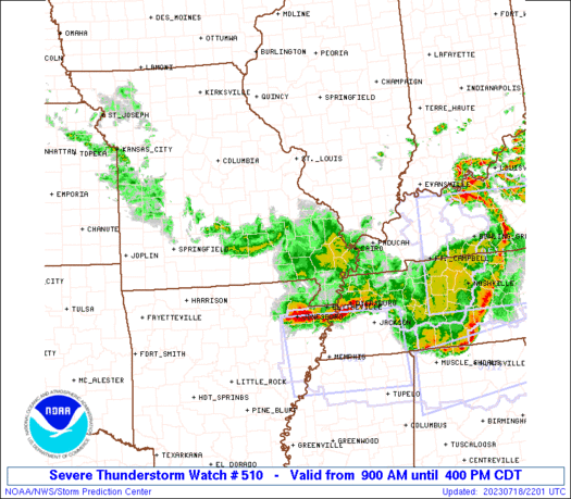
SUMMARY...A complex of severe thunderstorms will move rapidly
southeast through this afternoon with damaging winds, potentially to
75 mph as the primary severe weather risk. Isolated large hail is
also possible, and a tornado or two may also occur.
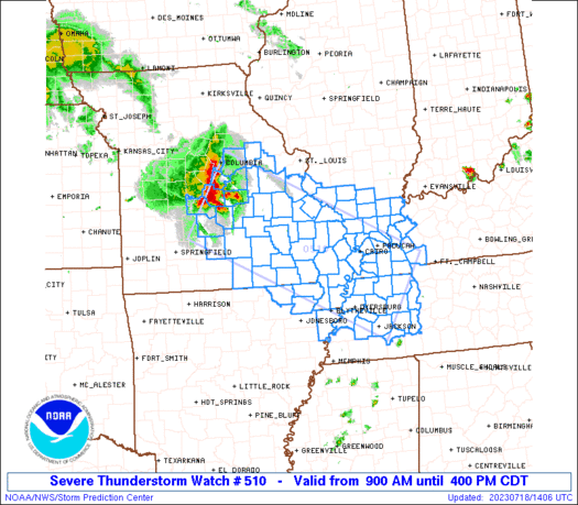
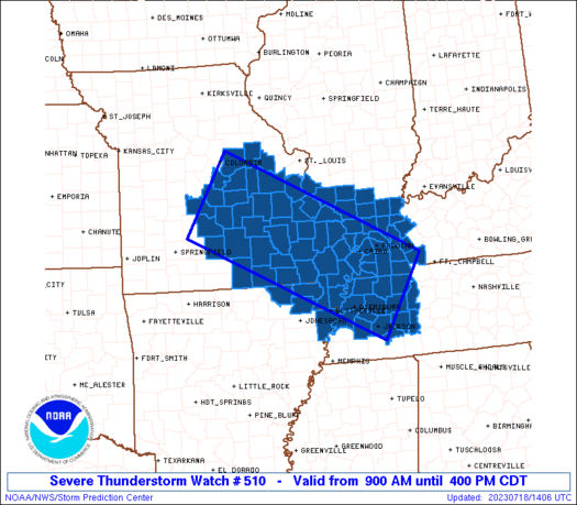
The severe thunderstorm watch area is approximately along and 60
statute miles either side of a line from 35 miles southwest of
Jefferson City MO to 50 miles northeast of Jackson TN. For a
complete depiction of the watch see the associated watch outline
update (WOUS64 KWNS WOU0).
PRECAUTIONARY/PREPAREDNESS ACTIONS...
REMEMBER...A Severe Thunderstorm Watch means conditions are
favorable for severe thunderstorms in and close to the watch area.
Persons in these areas should be on the lookout for threatening
weather conditions and listen for later statements and possible
warnings. Severe thunderstorms can and occasionally do produce
tornadoes.
&&
AVIATION...A few severe thunderstorms with hail surface and aloft to
2 inches. Extreme turbulence and surface wind gusts to 65 knots. A
few cumulonimbi with maximum tops to 550. Mean storm motion vector
30045.
...Bunting
   SEL0

   URGENT - IMMEDIATE BROADCAST REQUESTED
   Severe Thunderstorm Watch Number 510
   NWS Storm Prediction Center Norman OK
   900 AM CDT Tue Jul 18 2023

   The NWS Storm Prediction Center has issued a

   * Severe Thunderstorm Watch for portions of
     Northeast Arkansas
     Southern Illinois
     Western Kentucky
     Central and southern Missouri
     Western Tennessee

   * Effective this Tuesday morning and afternoon from 900 AM until
     400 PM CDT.

   * Primary threats include...
     Scattered large hail and isolated very large hail events to 2
       inches in diameter likely
     Scattered damaging winds likely with isolated significant gusts
       to 75 mph possible
     A tornado or two possible

   SUMMARY...A complex of severe thunderstorms will move rapidly
   southeast through this afternoon with damaging winds, potentially to
   75 mph as the primary severe weather risk.  Isolated large hail is
   also possible, and a tornado or two may also occur.

   The severe thunderstorm watch area is approximately along and 60
   statute miles either side of a line from 35 miles southwest of
   Jefferson City MO to 50 miles northeast of Jackson TN. For a
   complete depiction of the watch see the associated watch outline
   update (WOUS64 KWNS WOU0).

   PRECAUTIONARY/PREPAREDNESS ACTIONS...

   REMEMBER...A Severe Thunderstorm Watch means conditions are
   favorable for severe thunderstorms in and close to the watch area.
   Persons in these areas should be on the lookout for threatening
   weather conditions and listen for later statements and possible
   warnings. Severe thunderstorms can and occasionally do produce
   tornadoes.

   &&

   AVIATION...A few severe thunderstorms with hail surface and aloft to
   2 inches. Extreme turbulence and surface wind gusts to 65 knots. A
   few cumulonimbi with maximum tops to 550. Mean storm motion vector
   30045.

   ...Bunting
 Note:
The Aviation Watch (SAW) product is an approximation to the watch area.
The actual watch is depicted by the shaded areas.
Note:
The Aviation Watch (SAW) product is an approximation to the watch area.
The actual watch is depicted by the shaded areas.
   SAW0
   WW 510 SEVERE TSTM AR IL KY MO TN 181400Z - 182100Z
   AXIS..60 STATUTE MILES EITHER SIDE OF LINE..
   35SW JEF/JEFFERSON CITY MO/ - 50NE MKL/JACKSON TN/
   ..AVIATION COORDS.. 50NM EITHER SIDE /39SSW COU - 50E DYR/
   HAIL SURFACE AND ALOFT..2 INCHES. WIND GUSTS..65 KNOTS.
   MAX TOPS TO 550. MEAN STORM MOTION VECTOR 30045.

   LAT...LON 39009210 36888779 35348877 37479310

   THIS IS AN APPROXIMATION TO THE WATCH AREA.  FOR A
   COMPLETE DEPICTION OF THE WATCH SEE WOUS64 KWNS
   FOR WOU0.
Watch 510 Status Report Messages:
STATUS REPORT #3 ON WW 510

VALID 181925Z - 182040Z

SEVERE WEATHER THREAT CONTINUES RIGHT OF A LINE FROM 10 SE ARG TO
30 SSE PAH TO 35 ENE PAH.

..WEINMAN..07/18/23

ATTN...WFO...MEG...LZK...PAH...LSX...SGF...

&&

STATUS REPORT FOR WS 510

SEVERE WEATHER THREAT CONTINUES FOR THE FOLLOWING AREAS

ARC093-182040-

AR
.    ARKANSAS COUNTIES INCLUDED ARE

MISSISSIPPI
$$


KYC035-055-075-083-105-143-157-221-182040-

KY
.    KENTUCKY COUNTIES INCLUDED ARE

CALLOWAY	     CRITTENDEN 	 FULTON
GRAVES		     HICKMAN		 LYON
MARSHALL	     TRIGG
$$


MOC069-155-182040-

MO
.    MISSOURI COUNTIES INCLUDED ARE

DUNKLIN 	     PEMISCOT
$$


TNC005-017-023-033-039-045-053-075-077-079-095-097-113-131-183-
182040-

TN
.    TENNESSEE COUNTIES INCLUDED ARE

BENTON		     CARROLL		 CHESTER
CROCKETT	     DECATUR		 DYER
GIBSON		     HAYWOOD		 HENDERSON
HENRY		     LAKE		 LAUDERDALE
MADISON 	     OBION		 WEAKLEY
$$


THE WATCH STATUS MESSAGE IS FOR GUIDANCE PURPOSES ONLY.  PLEASE
REFER TO WATCH COUNTY NOTIFICATION STATEMENTS FOR OFFICIAL
INFORMATION ON COUNTIES...INDEPENDENT CITIES AND MARINE ZONES
CLEARED FROM SEVERE THUNDERSTORM AND TORNADO WATCHES.
$$

STATUS REPORT #2 ON WW 510

VALID 181825Z - 181940Z

SEVERE WEATHER THREAT CONTINUES RIGHT OF A LINE FROM 25 WSW JEF
TO 35 WSW FAM TO 25 SSE CGI TO 15 W PAH TO 15 ENE MDH.

FOR ADDITIONAL INFORMATION SEE MESOSCALE DISCUSSION 1615

..WEINMAN..07/18/23

ATTN...WFO...MEG...LZK...PAH...LSX...SGF...

&&

STATUS REPORT FOR WS 510

SEVERE WEATHER THREAT CONTINUES FOR THE FOLLOWING AREAS

ARC021-055-093-121-181940-

AR
.    ARKANSAS COUNTIES INCLUDED ARE

CLAY		     GREENE		 MISSISSIPPI
RANDOLPH
$$


ILC055-059-069-087-127-151-165-199-181940-

IL
.    ILLINOIS COUNTIES INCLUDED ARE

FRANKLIN	     GALLATIN		 HARDIN
JOHNSON 	     MASSAC		 POPE
SALINE		     WILLIAMSON
$$


KYC007-035-039-055-075-083-105-139-143-145-157-221-181940-

KY
.    KENTUCKY COUNTIES INCLUDED ARE

BALLARD 	     CALLOWAY		 CARLISLE
CRITTENDEN	     FULTON		 GRAVES
HICKMAN 	     LIVINGSTON 	 LYON
MCCRACKEN	     MARSHALL		 TRIGG
$$


MOC023-029-035-065-069-091-105-125-131-133-143-149-155-161-169-
179-181-203-207-215-223-229-181940-

MO
.    MISSOURI COUNTIES INCLUDED ARE

BUTLER		     CAMDEN		 CARTER
DENT		     DUNKLIN		 HOWELL
LACLEDE 	     MARIES		 MILLER
MISSISSIPPI	     NEW MADRID 	 OREGON
PEMISCOT	     PHELPS		 PULASKI
REYNOLDS	     RIPLEY		 SHANNON
STODDARD	     TEXAS		 WAYNE
WRIGHT
$$


TNC005-017-023-033-039-045-053-075-077-079-095-097-113-131-183-
181940-

TN
.    TENNESSEE COUNTIES INCLUDED ARE

BENTON		     CARROLL		 CHESTER
CROCKETT	     DECATUR		 DYER
GIBSON		     HAYWOOD		 HENDERSON
HENRY		     LAKE		 LAUDERDALE
MADISON 	     OBION		 WEAKLEY
$$


THE WATCH STATUS MESSAGE IS FOR GUIDANCE PURPOSES ONLY.  PLEASE
REFER TO WATCH COUNTY NOTIFICATION STATEMENTS FOR OFFICIAL
INFORMATION ON COUNTIES...INDEPENDENT CITIES AND MARINE ZONES
CLEARED FROM SEVERE THUNDERSTORM AND TORNADO WATCHES.
$$

STATUS REPORT #1 ON WW 510

VALID 181630Z - 181740Z

SEVERE WEATHER THREAT CONTINUES RIGHT OF A LINE FROM 25 WSW JEF
TO 10 SSE VIH TO 35 WSW FAM TO 10 S FAM TO 10 SSW BLV.

FOR ADDITIONAL INFORMATION SEE MESOSCALE DISCUSSION 1613

..HART..07/18/23

ATTN...WFO...MEG...LZK...PAH...LSX...SGF...

&&

STATUS REPORT FOR WS 510

SEVERE WEATHER THREAT CONTINUES FOR THE FOLLOWING AREAS

ARC021-055-093-121-181740-

AR
.    ARKANSAS COUNTIES INCLUDED ARE

CLAY		     GREENE		 MISSISSIPPI
RANDOLPH
$$


ILC003-055-059-069-077-087-127-145-151-153-157-165-181-199-
181740-

IL
.    ILLINOIS COUNTIES INCLUDED ARE

ALEXANDER	     FRANKLIN		 GALLATIN
HARDIN		     JACKSON		 JOHNSON
MASSAC		     PERRY		 POPE
PULASKI 	     RANDOLPH		 SALINE
UNION		     WILLIAMSON
$$


KYC007-035-039-055-075-083-105-139-143-145-157-221-181740-

KY
.    KENTUCKY COUNTIES INCLUDED ARE

BALLARD 	     CALLOWAY		 CARLISLE
CRITTENDEN	     FULTON		 GRAVES
HICKMAN 	     LIVINGSTON 	 LYON
MCCRACKEN	     MARSHALL		 TRIGG
$$


MOC017-023-029-031-035-065-069-091-105-123-125-131-133-143-149-
155-157-161-169-179-181-186-201-203-207-215-223-229-181740-

MO
.    MISSOURI COUNTIES INCLUDED ARE

BOLLINGER	     BUTLER		 CAMDEN
CAPE GIRARDEAU	     CARTER		 DENT
DUNKLIN 	     HOWELL		 LACLEDE
MADISON 	     MARIES		 MILLER
MISSISSIPPI	     NEW MADRID 	 OREGON
PEMISCOT	     PERRY		 PHELPS
PULASKI 	     REYNOLDS		 RIPLEY
STE. GENEVIEVE	     SCOTT		 SHANNON
STODDARD	     TEXAS		 WAYNE
WRIGHT
$$


TNC005-017-023-033-039-045-053-075-077-079-095-097-113-131-183-
181740-

TN
.    TENNESSEE COUNTIES INCLUDED ARE

BENTON		     CARROLL		 CHESTER
CROCKETT	     DECATUR		 DYER
GIBSON		     HAYWOOD		 HENDERSON
HENRY		     LAKE		 LAUDERDALE
MADISON 	     OBION		 WEAKLEY
$$


THE WATCH STATUS MESSAGE IS FOR GUIDANCE PURPOSES ONLY.  PLEASE
REFER TO WATCH COUNTY NOTIFICATION STATEMENTS FOR OFFICIAL
INFORMATION ON COUNTIES...INDEPENDENT CITIES AND MARINE ZONES
CLEARED FROM SEVERE THUNDERSTORM AND TORNADO WATCHES.
$$
Note:
Click for Complete Product Text.
Tornadoes
Probability of 2 or more tornadoes
|
Low (20%)
|
Probability of 1 or more strong (EF2-EF5) tornadoes
|
Low (<2%)
|
Wind
Probability of 10 or more severe wind events
|
High (70%)
|
Probability of 1 or more wind events > 65 knots
|
Mod (30%)
|
Hail
Probability of 10 or more severe hail events
|
Mod (60%)
|
Probability of 1 or more hailstones > 2 inches
|
Mod (60%)
|
Combined Severe Hail/Wind
Probability of 6 or more combined severe hail/wind events
|
High (>95%)
|
For each watch, probabilities for particular events inside the watch
(listed above in each table) are determined by the issuing forecaster.
The "Low" category contains probability values ranging from less than 2%
to 20% (EF2-EF5 tornadoes), less than 5% to 20% (all other probabilities),
"Moderate" from 30% to 60%, and "High" from 70% to greater than 95%.
High values are bolded and lighter in color to provide awareness of
an increased threat for a particular event.


 @NWSSPC


