 Note:
The expiration time in the watch graphic is amended if the watch is
replaced, cancelled or extended.
Note:
Note:
The expiration time in the watch graphic is amended if the watch is
replaced, cancelled or extended.
Note: Click for
Watch Status Reports.
SEL1
URGENT - IMMEDIATE BROADCAST REQUESTED
Severe Thunderstorm Watch Number 511
NWS Storm Prediction Center Norman OK
110 PM CDT Tue Jul 18 2023
The NWS Storm Prediction Center has issued a
* Severe Thunderstorm Watch for portions of
Western and central Kentucky
Western and middle Tennessee
* Effective this Tuesday afternoon and evening from 110 PM until
800 PM CDT.
* Primary threats include...
Scattered damaging winds likely with isolated significant gusts
to 75 mph possible
Scattered large hail events to 1.5 inches in diameter possible
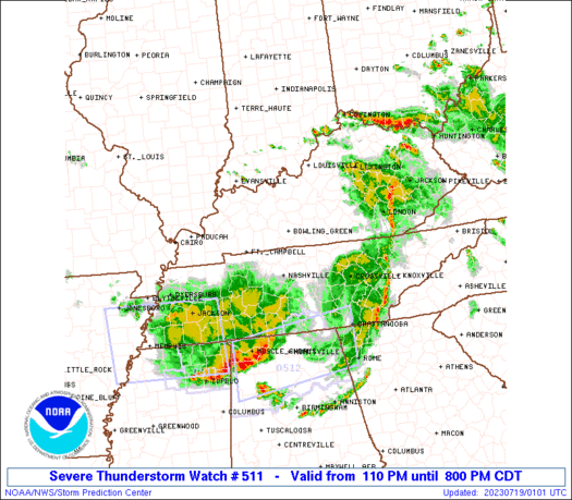
SUMMARY...A line of severe thunderstorms will move rapidly across
the watch area this afternoon with the potential for damaging wind
gusts to 75 mph. A tornado or two is also possible, in addition to
isolated reports of large hail.
The severe thunderstorm watch area is approximately along and 75
statute miles north and south of a line from 55 miles north
northeast of Crossville TN to 10 miles west northwest of Fort
Campbell KY. For a complete depiction of the watch see the
associated watch outline update (WOUS64 KWNS WOU1).
PRECAUTIONARY/PREPAREDNESS ACTIONS...
REMEMBER...A Severe Thunderstorm Watch means conditions are
favorable for severe thunderstorms in and close to the watch area.
Persons in these areas should be on the lookout for threatening
weather conditions and listen for later statements and possible
warnings. Severe thunderstorms can and occasionally do produce
tornadoes.
&&
OTHER WATCH INFORMATION...CONTINUE...WW 510...
AVIATION...A few severe thunderstorms with hail surface and aloft to
1.5 inches. Extreme turbulence and surface wind gusts to 65 knots. A
few cumulonimbi with maximum tops to 500. Mean storm motion vector
28045.
...Bunting
   SEL1

   URGENT - IMMEDIATE BROADCAST REQUESTED
   Severe Thunderstorm Watch Number 511
   NWS Storm Prediction Center Norman OK
   110 PM CDT Tue Jul 18 2023

   The NWS Storm Prediction Center has issued a

   * Severe Thunderstorm Watch for portions of
     Western and central Kentucky
     Western and middle Tennessee

   * Effective this Tuesday afternoon and evening from 110 PM until
     800 PM CDT.

   * Primary threats include...
     Scattered damaging winds likely with isolated significant gusts
       to 75 mph possible
     Scattered large hail events to 1.5 inches in diameter possible

   SUMMARY...A line of severe thunderstorms will move rapidly across
   the watch area this afternoon with the potential for damaging wind
   gusts to 75 mph.  A tornado or two is also possible, in addition to
   isolated reports of large hail.

   The severe thunderstorm watch area is approximately along and 75
   statute miles north and south of a line from 55 miles north
   northeast of Crossville TN to 10 miles west northwest of Fort
   Campbell KY. For a complete depiction of the watch see the
   associated watch outline update (WOUS64 KWNS WOU1).

   PRECAUTIONARY/PREPAREDNESS ACTIONS...

   REMEMBER...A Severe Thunderstorm Watch means conditions are
   favorable for severe thunderstorms in and close to the watch area.
   Persons in these areas should be on the lookout for threatening
   weather conditions and listen for later statements and possible
   warnings. Severe thunderstorms can and occasionally do produce
   tornadoes.

   &&

   OTHER WATCH INFORMATION...CONTINUE...WW 510...

   AVIATION...A few severe thunderstorms with hail surface and aloft to
   1.5 inches. Extreme turbulence and surface wind gusts to 65 knots. A
   few cumulonimbi with maximum tops to 500. Mean storm motion vector
   28045.

   ...Bunting
 Note:
The Aviation Watch (SAW) product is an approximation to the watch area.
The actual watch is depicted by the shaded areas.
Note:
The Aviation Watch (SAW) product is an approximation to the watch area.
The actual watch is depicted by the shaded areas.
SAW1
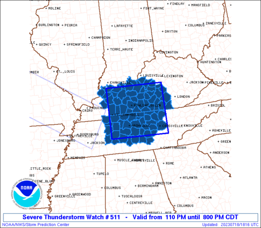
WW 511 SEVERE TSTM KY TN 181810Z - 190100Z
AXIS..75 STATUTE MILES NORTH AND SOUTH OF LINE..
55NNE CSV/CROSSVILLE TN/ - 10WNW HOP/FORT CAMPBELL KY/
..AVIATION COORDS.. 65NM N/S /35SW LOZ - 58NW BNA/
HAIL SURFACE AND ALOFT..1.5 INCHES. WIND GUSTS..65 KNOTS.
MAX TOPS TO 500. MEAN STORM MOTION VECTOR 28045.
LAT...LON 35598470 35648765 37818765 37778470
THIS IS AN APPROXIMATION TO THE WATCH AREA. FOR A
COMPLETE DEPICTION OF THE WATCH SEE WOUS64 KWNS
FOR WOU1.
Watch 511 Status Report Messages:
STATUS REPORT #1 ON WW 511

VALID 182045Z - 182140Z

SEVERE WEATHER THREAT CONTINUES RIGHT OF A LINE FROM 50 SW CKV TO
25 ESE CKV TO 15 SE OWB TO 25 SW EVV.

FOR ADDITIONAL INFORMATION SEE MESOSCALE DISCUSSION 1618

..WEINMAN..07/18/23

ATTN...WFO...LMK...PAH...JKL...OHX...

&&

STATUS REPORT FOR WS 511

SEVERE WEATHER THREAT CONTINUES FOR THE FOLLOWING AREAS

KYC001-003-009-021-027-029-031-045-053-057-059-061-085-087-091-
093-099-101-123-137-141-147-155-163-169-171-179-183-199-207-213-
217-227-229-231-182140-

KY
.    KENTUCKY COUNTIES INCLUDED ARE

ADAIR		     ALLEN		 BARREN
BOYLE		     BRECKINRIDGE	 BULLITT
BUTLER		     CASEY		 CLINTON
CUMBERLAND	     DAVIESS		 EDMONSON
GRAYSON 	     GREEN		 HANCOCK
HARDIN		     HART		 HENDERSON
LARUE		     LINCOLN		 LOGAN
MCCREARY	     MARION		 MEADE
METCALFE	     MONROE		 NELSON
OHIO		     PULASKI		 RUSSELL
SIMPSON 	     TAYLOR		 WARREN
WASHINGTON	     WAYNE
$$


TNC003-015-021-027-031-035-037-041-043-049-055-061-081-085-087-
099-101-111-117-119-133-135-137-141-147-149-159-165-169-175-177-
181-185-187-189-182140-

TN
.    TENNESSEE COUNTIES INCLUDED ARE

BEDFORD 	     CANNON		 CHEATHAM
CLAY		     COFFEE		 CUMBERLAND
DAVIDSON	     DE KALB		 DICKSON
FENTRESS	     GILES		 GRUNDY
HICKMAN 	     HUMPHREYS		 JACKSON
LAWRENCE	     LEWIS		 MACON
MARSHALL	     MAURY		 OVERTON
PERRY		     PICKETT		 PUTNAM
ROBERTSON	     RUTHERFORD 	 SMITH
SUMNER		     TROUSDALE		 VAN BUREN
WARREN		     WAYNE		 WHITE
WILLIAMSON	     WILSON
$$


THE WATCH STATUS MESSAGE IS FOR GUIDANCE PURPOSES ONLY.  PLEASE
REFER TO WATCH COUNTY NOTIFICATION STATEMENTS FOR OFFICIAL
INFORMATION ON COUNTIES...INDEPENDENT CITIES AND MARINE ZONES
CLEARED FROM SEVERE THUNDERSTORM AND TORNADO WATCHES.
$$
Note:
Click for Complete Product Text.
Tornadoes
Probability of 2 or more tornadoes
|
Low (10%)
|
Probability of 1 or more strong (EF2-EF5) tornadoes
|
Low (<2%)
|
Wind
Probability of 10 or more severe wind events
|
Mod (60%)
|
Probability of 1 or more wind events > 65 knots
|
Mod (30%)
|
Hail
Probability of 10 or more severe hail events
|
Mod (40%)
|
Probability of 1 or more hailstones > 2 inches
|
Low (10%)
|
Combined Severe Hail/Wind
Probability of 6 or more combined severe hail/wind events
|
High (90%)
|
For each watch, probabilities for particular events inside the watch
(listed above in each table) are determined by the issuing forecaster.
The "Low" category contains probability values ranging from less than 2%
to 20% (EF2-EF5 tornadoes), less than 5% to 20% (all other probabilities),
"Moderate" from 30% to 60%, and "High" from 70% to greater than 95%.
High values are bolded and lighter in color to provide awareness of
an increased threat for a particular event.


 @NWSSPC


