 Note:
The expiration time in the watch graphic is amended if the watch is
replaced, cancelled or extended.
Note:
Note:
The expiration time in the watch graphic is amended if the watch is
replaced, cancelled or extended.
Note: Click for
Watch Status Reports.
SEL3
URGENT - IMMEDIATE BROADCAST REQUESTED
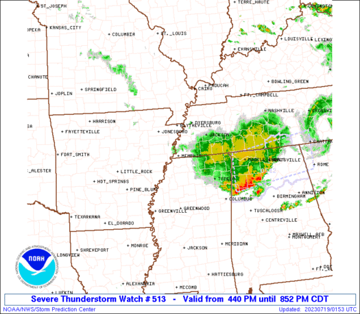
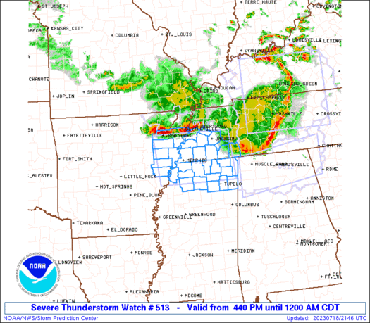
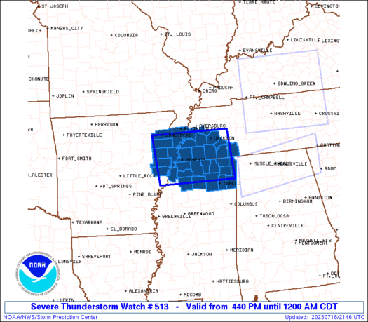
Severe Thunderstorm Watch Number 513
NWS Storm Prediction Center Norman OK
440 PM CDT Tue Jul 18 2023
The NWS Storm Prediction Center has issued a
* Severe Thunderstorm Watch for portions of
Eastern Arkansas
Northern Mississippi
Southwestern Tennessee
* Effective this Tuesday afternoon from 440 PM until Midnight
CDT.
* Primary threats include...
Scattered damaging winds and isolated significant gusts to 75
mph possible
Isolated large hail events to 1.5 inches in diameter possible
SUMMARY...Another strong-severe thunderstorm complex, this one
initially over northeastern AR, is expected to move southeastward
near an outflow boundary from the earlier activity. Damaging to
severe gusts and isolated large hail are the primary concerns.
The severe thunderstorm watch area is approximately along and 75
statute miles east and west of a line from 45 miles west northwest
of Jackson TN to Oxford MS. For a complete depiction of the watch
see the associated watch outline update (WOUS64 KWNS WOU3).
PRECAUTIONARY/PREPAREDNESS ACTIONS...
REMEMBER...A Severe Thunderstorm Watch means conditions are
favorable for severe thunderstorms in and close to the watch area.
Persons in these areas should be on the lookout for threatening
weather conditions and listen for later statements and possible
warnings. Severe thunderstorms can and occasionally do produce
tornadoes.
&&
OTHER WATCH INFORMATION...CONTINUE...WW 511...WW 512...
AVIATION...A few severe thunderstorms with hail surface and aloft to
1.5 inches. Extreme turbulence and surface wind gusts to 65 knots. A
few cumulonimbi with maximum tops to 550. Mean storm motion vector
32035.
...Edwards
   SEL3

   URGENT - IMMEDIATE BROADCAST REQUESTED
   Severe Thunderstorm Watch Number 513
   NWS Storm Prediction Center Norman OK
   440 PM CDT Tue Jul 18 2023

   The NWS Storm Prediction Center has issued a

   * Severe Thunderstorm Watch for portions of
     Eastern Arkansas
     Northern Mississippi
     Southwestern Tennessee

   * Effective this Tuesday afternoon from 440 PM until Midnight
     CDT.

   * Primary threats include...
     Scattered damaging winds and isolated significant gusts to 75
       mph possible
     Isolated large hail events to 1.5 inches in diameter possible

   SUMMARY...Another strong-severe thunderstorm complex, this one
   initially over northeastern AR, is expected to move southeastward
   near an outflow boundary from the earlier activity.  Damaging to
   severe gusts and isolated large hail are the primary concerns.

   The severe thunderstorm watch area is approximately along and 75
   statute miles east and west of a line from 45 miles west northwest
   of Jackson TN to Oxford MS. For a complete depiction of the watch
   see the associated watch outline update (WOUS64 KWNS WOU3).

   PRECAUTIONARY/PREPAREDNESS ACTIONS...

   REMEMBER...A Severe Thunderstorm Watch means conditions are
   favorable for severe thunderstorms in and close to the watch area.
   Persons in these areas should be on the lookout for threatening
   weather conditions and listen for later statements and possible
   warnings. Severe thunderstorms can and occasionally do produce
   tornadoes.

   &&

   OTHER WATCH INFORMATION...CONTINUE...WW 511...WW 512...

   AVIATION...A few severe thunderstorms with hail surface and aloft to
   1.5 inches. Extreme turbulence and surface wind gusts to 65 knots. A
   few cumulonimbi with maximum tops to 550. Mean storm motion vector
   32035.

   ...Edwards
 Note:
The Aviation Watch (SAW) product is an approximation to the watch area.
The actual watch is depicted by the shaded areas.
Note:
The Aviation Watch (SAW) product is an approximation to the watch area.
The actual watch is depicted by the shaded areas.
   SAW3
   WW 513 SEVERE TSTM AR MS TN 182140Z - 190500Z
   AXIS..75 STATUTE MILES EAST AND WEST OF LINE..
   45WNW MKL/JACKSON TN/ - UOX/OXFORD MS/
   ..AVIATION COORDS.. 65NM E/W /20WSW DYR - 46SSE MEM/
   HAIL SURFACE AND ALOFT..1.5 INCHES. WIND GUSTS..65 KNOTS.
   MAX TOPS TO 550. MEAN STORM MOTION VECTOR 32035.

   LAT...LON 35848832 34378821 34379085 35849100

   THIS IS AN APPROXIMATION TO THE WATCH AREA.  FOR A
   COMPLETE DEPICTION OF THE WATCH SEE WOUS64 KWNS
   FOR WOU3.
Watch 513 Status Report Message has not been issued yet.
Note:
Click for Complete Product Text.
Tornadoes
Probability of 2 or more tornadoes
|
Low (10%)
|
Probability of 1 or more strong (EF2-EF5) tornadoes
|
Low (<2%)
|
Wind
Probability of 10 or more severe wind events
|
Mod (40%)
|
Probability of 1 or more wind events > 65 knots
|
Mod (30%)
|
Hail
Probability of 10 or more severe hail events
|
Mod (30%)
|
Probability of 1 or more hailstones > 2 inches
|
Low (20%)
|
Combined Severe Hail/Wind
Probability of 6 or more combined severe hail/wind events
|
High (70%)
|
For each watch, probabilities for particular events inside the watch
(listed above in each table) are determined by the issuing forecaster.
The "Low" category contains probability values ranging from less than 2%
to 20% (EF2-EF5 tornadoes), less than 5% to 20% (all other probabilities),
"Moderate" from 30% to 60%, and "High" from 70% to greater than 95%.
High values are bolded and lighter in color to provide awareness of
an increased threat for a particular event.


 @NWSSPC


