 Note:
The expiration time in the watch graphic is amended if the watch is
replaced, cancelled or extended.
Note:
Note:
The expiration time in the watch graphic is amended if the watch is
replaced, cancelled or extended.
Note: Click for
Watch Status Reports.
SEL7
URGENT - IMMEDIATE BROADCAST REQUESTED
Severe Thunderstorm Watch Number 617
NWS Storm Prediction Center Norman OK
150 PM CDT Wed Aug 9 2023
The NWS Storm Prediction Center has issued a
* Severe Thunderstorm Watch for portions of
Northern Alabama
Northeast Mississippi
Middle Tennessee
* Effective this Wednesday afternoon and evening from 150 PM
until 800 PM CDT.
* Primary threats include...
Scattered damaging wind gusts to 65 mph likely
Isolated large hail events to 1.5 inches in diameter possible
A tornado or two possible
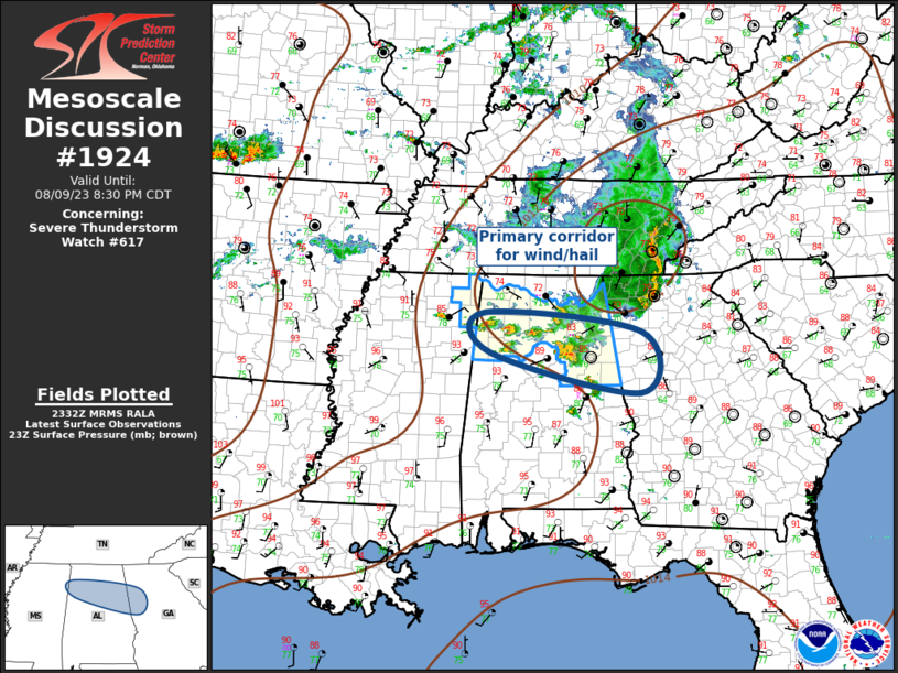
SUMMARY...Storms are expected to increase and intensify along a warm
front/instability gradient across the region, with wind profiles
supportive of a few supercells and bowing segments.
The severe thunderstorm watch area is approximately along and 55
statute miles north and south of a line from 40 miles west northwest
of Muscle Shoals AL to 50 miles north northeast of Gadsden AL. For a
complete depiction of the watch see the associated watch outline
update (WOUS64 KWNS WOU7).
PRECAUTIONARY/PREPAREDNESS ACTIONS...
REMEMBER...A Severe Thunderstorm Watch means conditions are
favorable for severe thunderstorms in and close to the watch area.
Persons in these areas should be on the lookout for threatening
weather conditions and listen for later statements and possible
warnings. Severe thunderstorms can and occasionally do produce
tornadoes.
&&
AVIATION...A few severe thunderstorms with hail surface and aloft to
1.5 inches. Extreme turbulence and surface wind gusts to 55 knots. A
few cumulonimbi with maximum tops to 550. Mean storm motion vector
28025.
...Guyer
   SEL7

   URGENT - IMMEDIATE BROADCAST REQUESTED
   Severe Thunderstorm Watch Number 617
   NWS Storm Prediction Center Norman OK
   150 PM CDT Wed Aug 9 2023

   The NWS Storm Prediction Center has issued a

   * Severe Thunderstorm Watch for portions of
     Northern Alabama
     Northeast Mississippi
     Middle Tennessee

   * Effective this Wednesday afternoon and evening from 150 PM
     until 800 PM CDT.

   * Primary threats include...
     Scattered damaging wind gusts to 65 mph likely
     Isolated large hail events to 1.5 inches in diameter possible
     A tornado or two possible

   SUMMARY...Storms are expected to increase and intensify along a warm
   front/instability gradient across the region, with wind profiles
   supportive of a few supercells and bowing segments.

   The severe thunderstorm watch area is approximately along and 55
   statute miles north and south of a line from 40 miles west northwest
   of Muscle Shoals AL to 50 miles north northeast of Gadsden AL. For a
   complete depiction of the watch see the associated watch outline
   update (WOUS64 KWNS WOU7).

   PRECAUTIONARY/PREPAREDNESS ACTIONS...

   REMEMBER...A Severe Thunderstorm Watch means conditions are
   favorable for severe thunderstorms in and close to the watch area.
   Persons in these areas should be on the lookout for threatening
   weather conditions and listen for later statements and possible
   warnings. Severe thunderstorms can and occasionally do produce
   tornadoes.

   &&

   AVIATION...A few severe thunderstorms with hail surface and aloft to
   1.5 inches. Extreme turbulence and surface wind gusts to 55 knots. A
   few cumulonimbi with maximum tops to 550. Mean storm motion vector
   28025.

   ...Guyer
 Note:
The Aviation Watch (SAW) product is an approximation to the watch area.
The actual watch is depicted by the shaded areas.
Note:
The Aviation Watch (SAW) product is an approximation to the watch area.
The actual watch is depicted by the shaded areas.
SAW7
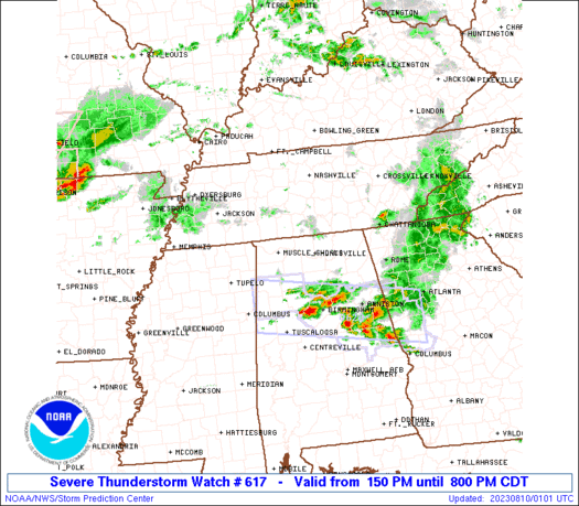
WW 617 SEVERE TSTM AL MS TN 091850Z - 100100Z
AXIS..55 STATUTE MILES NORTH AND SOUTH OF LINE..
40WNW MSL/MUSCLE SHOALS AL/ - 50NNE GAD/GADSDEN AL/
..AVIATION COORDS.. 50NM N/S /42WNW MSL - 35WSW GQO/
HAIL SURFACE AND ALOFT..1.5 INCHES. WIND GUSTS..55 KNOTS.
MAX TOPS TO 550. MEAN STORM MOTION VECTOR 28025.
LAT...LON 35778827 35438574 33848574 34168827
THIS IS AN APPROXIMATION TO THE WATCH AREA. FOR A
COMPLETE DEPICTION OF THE WATCH SEE WOUS64 KWNS
FOR WOU7.
Watch 617 Status Report Messages:
STATUS REPORT #3 ON WW 617
VALID 092250Z - 092340Z
SEVERE WEATHER THREAT CONTINUES RIGHT OF A LINE FROM 45 SSE MKL
TO 5 S HSV TO 25 SSW CHA.
..WEINMAN..08/09/23
ATTN...WFO...BMX...HUN...MEG...OHX...
&&
STATUS REPORT FOR WS 617
SEVERE WEATHER THREAT CONTINUES FOR THE FOLLOWING AREAS
ALC009-015-019-029-033-043-049-055-057-059-075-079-093-095-103-
115-127-133-092340-
AL
. ALABAMA COUNTIES INCLUDED ARE
BLOUNT CALHOUN CHEROKEE
CLEBURNE COLBERT CULLMAN
DEKALB ETOWAH FAYETTE
FRANKLIN LAMAR LAWRENCE
MARION MARSHALL MORGAN
ST. CLAIR WALKER WINSTON
$$
MSC057-117-141-092340-
MS
. MISSISSIPPI COUNTIES INCLUDED ARE
ITAWAMBA PRENTISS TISHOMINGO
$$
THE WATCH STATUS MESSAGE IS FOR GUIDANCE PURPOSES ONLY. PLEASE
REFER TO WATCH COUNTY NOTIFICATION STATEMENTS FOR OFFICIAL
INFORMATION ON COUNTIES...INDEPENDENT CITIES AND MARINE ZONES
CLEARED FROM SEVERE THUNDERSTORM AND TORNADO WATCHES.
$$
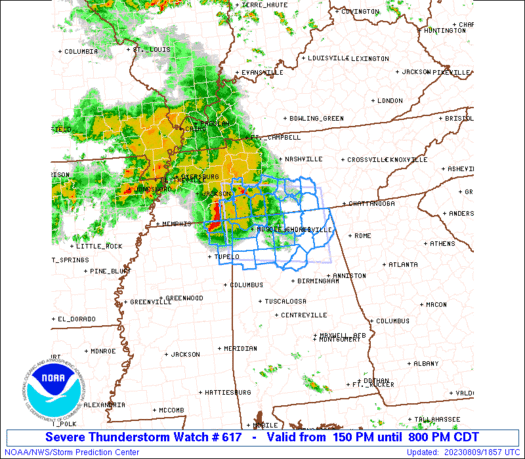
STATUS REPORT #2 ON WW 617
VALID 092200Z - 092340Z
SEVERE WEATHER THREAT CONTINUES RIGHT OF A LINE FROM 45 SSE MKL
TO 15 W CHA.
FOR ADDITIONAL INFORMATION SEE MESOSCALE DISCUSSION 1920
..WEINMAN..08/09/23
ATTN...WFO...BMX...HUN...MEG...OHX...
&&
STATUS REPORT FOR WS 617
SEVERE WEATHER THREAT CONTINUES FOR THE FOLLOWING AREAS
ALC009-019-033-043-049-055-057-059-071-075-077-079-083-089-093-
095-103-127-133-092340-
AL
. ALABAMA COUNTIES INCLUDED ARE
BLOUNT CHEROKEE COLBERT
CULLMAN DEKALB ETOWAH
FAYETTE FRANKLIN JACKSON
LAMAR LAUDERDALE LAWRENCE
LIMESTONE MADISON MARION
MARSHALL MORGAN WALKER
WINSTON
$$
MSC003-057-117-141-092340-
MS
. MISSISSIPPI COUNTIES INCLUDED ARE
ALCORN ITAWAMBA PRENTISS
TISHOMINGO
$$
THE WATCH STATUS MESSAGE IS FOR GUIDANCE PURPOSES ONLY. PLEASE
REFER TO WATCH COUNTY NOTIFICATION STATEMENTS FOR OFFICIAL
INFORMATION ON COUNTIES...INDEPENDENT CITIES AND MARINE ZONES
CLEARED FROM SEVERE THUNDERSTORM AND TORNADO WATCHES.
$$
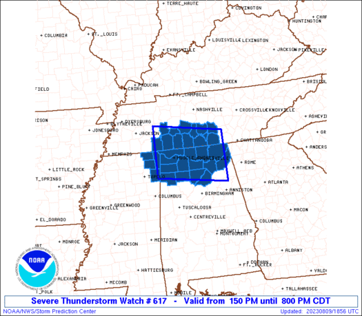
STATUS REPORT #1 ON WW 617
VALID 092035Z - 092140Z
SEVERE WEATHER THREAT CONTINUES RIGHT OF A LINE FROM 20 SE MKL TO
45 NNE MSL TO 20 SSW BNA.
..WEINMAN..08/09/23
ATTN...WFO...BMX...HUN...MEG...OHX...
&&
STATUS REPORT FOR WS 617
SEVERE WEATHER THREAT CONTINUES FOR THE FOLLOWING AREAS
ALC009-033-043-049-059-071-077-079-083-089-093-095-103-133-
092140-
AL
. ALABAMA COUNTIES INCLUDED ARE
BLOUNT COLBERT CULLMAN
DEKALB FRANKLIN JACKSON
LAUDERDALE LAWRENCE LIMESTONE
MADISON MARION MARSHALL
MORGAN WINSTON
$$
MSC003-057-117-141-092140-
MS
. MISSISSIPPI COUNTIES INCLUDED ARE
ALCORN ITAWAMBA PRENTISS
TISHOMINGO
$$
TNC003-031-051-055-071-099-103-117-119-127-181-092140-
TN
. TENNESSEE COUNTIES INCLUDED ARE
BEDFORD COFFEE FRANKLIN
GILES HARDIN LAWRENCE
LINCOLN MARSHALL MAURY
MOORE WAYNE
$$
THE WATCH STATUS MESSAGE IS FOR GUIDANCE PURPOSES ONLY. PLEASE
REFER TO WATCH COUNTY NOTIFICATION STATEMENTS FOR OFFICIAL
INFORMATION ON COUNTIES...INDEPENDENT CITIES AND MARINE ZONES
CLEARED FROM SEVERE THUNDERSTORM AND TORNADO WATCHES.
$$
Note:
Click for Complete Product Text.
Tornadoes
Probability of 2 or more tornadoes
|
Low (20%)
|
Probability of 1 or more strong (EF2-EF5) tornadoes
|
Low (20%)
|
Wind
Probability of 10 or more severe wind events
|
High (70%)
|
Probability of 1 or more wind events > 65 knots
|
Low (10%)
|
Hail
Probability of 10 or more severe hail events
|
Low (20%)
|
Probability of 1 or more hailstones > 2 inches
|
Low (<5%)
|
Combined Severe Hail/Wind
Probability of 6 or more combined severe hail/wind events
|
High (90%)
|
For each watch, probabilities for particular events inside the watch
(listed above in each table) are determined by the issuing forecaster.
The "Low" category contains probability values ranging from less than 2%
to 20% (EF2-EF5 tornadoes), less than 5% to 20% (all other probabilities),
"Moderate" from 30% to 60%, and "High" from 70% to greater than 95%.
High values are bolded and lighter in color to provide awareness of
an increased threat for a particular event.


 @NWSSPC