 Note:
The expiration time in the watch graphic is amended if the watch is
replaced, cancelled or extended.
Note:
Note:
The expiration time in the watch graphic is amended if the watch is
replaced, cancelled or extended.
Note: Click for
Watch Status Reports.
SEL5
URGENT - IMMEDIATE BROADCAST REQUESTED
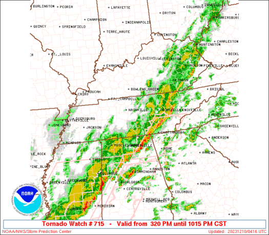
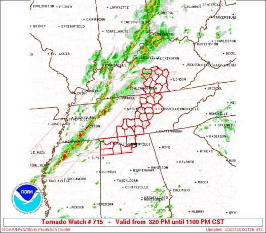
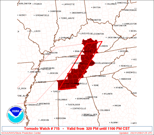
Tornado Watch Number 715
NWS Storm Prediction Center Norman OK
320 PM CST Sat Dec 9 2023
The NWS Storm Prediction Center has issued a
* Tornado Watch for portions of
Northern Alabama
Southern Kentucky
Middle Tennessee
* Effective this Saturday afternoon and evening from 320 PM until
1100 PM CST.
* Primary threats include...
A few tornadoes possible
Scattered damaging wind gusts to 70 mph possible
SUMMARY...Severe thunderstorms including a few long-lived supercells
will move across the region late this afternoon and evening, with
the potential for all severe hazards including a few tornadoes as
well as damaging winds and some hail.
The tornado watch area is approximately along and 40 statute miles
east and west of a line from 30 miles northwest of London KY to 30
miles south southeast of Muscle Shoals AL. For a complete depiction
of the watch see the associated watch outline update (WOUS64 KWNS
WOU5).
PRECAUTIONARY/PREPAREDNESS ACTIONS...
REMEMBER...A Tornado Watch means conditions are favorable for
tornadoes and severe thunderstorms in and close to the watch
area. Persons in these areas should be on the lookout for
threatening weather conditions and listen for later statements
and possible warnings.
&&
OTHER WATCH INFORMATION...CONTINUE...WW 714...
AVIATION...Tornadoes and a few severe thunderstorms with hail
surface and aloft to 1 inch. Extreme turbulence and surface wind
gusts to 60 knots. A few cumulonimbi with maximum tops to 450. Mean
storm motion vector 24040.
...Guyer
   SEL5

   URGENT - IMMEDIATE BROADCAST REQUESTED
   Tornado Watch Number 715
   NWS Storm Prediction Center Norman OK
   320 PM CST Sat Dec 9 2023

   The NWS Storm Prediction Center has issued a

   * Tornado Watch for portions of
     Northern Alabama
     Southern Kentucky
     Middle Tennessee

   * Effective this Saturday afternoon and evening from 320 PM until
     1100 PM CST.

   * Primary threats include...
     A few tornadoes possible
     Scattered damaging wind gusts to 70 mph possible

   SUMMARY...Severe thunderstorms including a few long-lived supercells
   will move across the region late this afternoon and evening, with
   the potential for all severe hazards including a few tornadoes as
   well as damaging winds and some hail.

   The tornado watch area is approximately along and 40 statute miles
   east and west of a line from 30 miles northwest of London KY to 30
   miles south southeast of Muscle Shoals AL. For a complete depiction
   of the watch see the associated watch outline update (WOUS64 KWNS
   WOU5).

   PRECAUTIONARY/PREPAREDNESS ACTIONS...

   REMEMBER...A Tornado Watch means conditions are favorable for
   tornadoes and severe thunderstorms in and close to the watch
   area. Persons in these areas should be on the lookout for
   threatening weather conditions and listen for later statements
   and possible warnings.

   &&

   OTHER WATCH INFORMATION...CONTINUE...WW 714...

   AVIATION...Tornadoes and a few severe thunderstorms with hail
   surface and aloft to 1 inch. Extreme turbulence and surface wind
   gusts to 60 knots. A few cumulonimbi with maximum tops to 450. Mean
   storm motion vector 24040.

   ...Guyer
 Note:
The Aviation Watch (SAW) product is an approximation to the watch area.
The actual watch is depicted by the shaded areas.
Note:
The Aviation Watch (SAW) product is an approximation to the watch area.
The actual watch is depicted by the shaded areas.
   SAW5
   WW 715 TORNADO AL KY TN 092120Z - 100500Z
   AXIS..40 STATUTE MILES EAST AND WEST OF LINE..
   30NW LOZ/LONDON KY/ - 30SSE MSL/MUSCLE SHOALS AL/
   ..AVIATION COORDS.. 35NM E/W /27NW LOZ - 21S MSL/
   HAIL SURFACE AND ALOFT..1 INCH. WIND GUSTS..60 KNOTS.
   MAX TOPS TO 450. MEAN STORM MOTION VECTOR 24040.

   LAT...LON 37388374 34348672 34348812 37388519

   THIS IS AN APPROXIMATION TO THE WATCH AREA.  FOR A
   COMPLETE DEPICTION OF THE WATCH SEE WOUS64 KWNS
   FOR WOU5.
Watch 715 Status Report Messages:
STATUS REPORT #4 ON WW 715

VALID 100335Z - 100440Z

SEVERE WEATHER THREAT CONTINUES RIGHT OF A LINE FROM 25 SE HSV TO
25 NE HSV TO 15 W CSV TO 40 NNE CSV TO 40 SSW LOZ.

..SQUITIERI..12/10/23

ATTN...WFO...HUN...LMK...JKL...OHX...

&&

STATUS REPORT FOR WT 715

SEVERE WEATHER THREAT CONTINUES FOR THE FOLLOWING AREAS

TNC035-049-051-061-175-100440-

TN
.    TENNESSEE COUNTIES INCLUDED ARE

CUMBERLAND	     FENTRESS		 FRANKLIN
GRUNDY		     VAN BUREN
$$


THE WATCH STATUS MESSAGE IS FOR GUIDANCE PURPOSES ONLY.  PLEASE
REFER TO WATCH COUNTY NOTIFICATION STATEMENTS FOR OFFICIAL
INFORMATION ON COUNTIES...INDEPENDENT CITIES AND MARINE ZONES
CLEARED FROM SEVERE THUNDERSTORM AND TORNADO WATCHES.
$$

STATUS REPORT #3 ON WW 715

VALID 100300Z - 100440Z

SEVERE WEATHER THREAT CONTINUES RIGHT OF A LINE FROM 40 SSW MSL
TO 20 SE MSL TO 55 SE BNA TO 35 WNW CSV TO 15 SW JKL.

FOR ADDITIONAL INFORMATION SEE MESOSCALE DISCUSSION 2314

..SQUITIERI..12/10/23

ATTN...WFO...HUN...LMK...JKL...OHX...

&&

STATUS REPORT FOR WT 715

SEVERE WEATHER THREAT CONTINUES FOR THE FOLLOWING AREAS

ALC079-083-089-103-100440-

AL
.    ALABAMA COUNTIES INCLUDED ARE

LAWRENCE	     LIMESTONE		 MADISON
MORGAN
$$


KYC147-100440-

KY
.    KENTUCKY COUNTIES INCLUDED ARE

MCCREARY
$$


TNC031-035-041-049-051-061-103-127-133-175-177-185-100440-

TN
.    TENNESSEE COUNTIES INCLUDED ARE

COFFEE		     CUMBERLAND 	 DE KALB
FENTRESS	     FRANKLIN		 GRUNDY
LINCOLN 	     MOORE		 OVERTON
VAN BUREN	     WARREN		 WHITE
$$


THE WATCH STATUS MESSAGE IS FOR GUIDANCE PURPOSES ONLY.  PLEASE
REFER TO WATCH COUNTY NOTIFICATION STATEMENTS FOR OFFICIAL
INFORMATION ON COUNTIES...INDEPENDENT CITIES AND MARINE ZONES
CLEARED FROM SEVERE THUNDERSTORM AND TORNADO WATCHES.
$$

STATUS REPORT #2 ON WW 715

VALID 100150Z - 100240Z

SEVERE WEATHER THREAT CONTINUES RIGHT OF A LINE FROM 25 WSW MSL
TO 5 NE MSL TO 50 S BNA TO 35 E BNA TO 30 N LOZ.

..SQUITIERI..12/10/23

ATTN...WFO...HUN...LMK...JKL...OHX...

&&

STATUS REPORT FOR WT 715

SEVERE WEATHER THREAT CONTINUES FOR THE FOLLOWING AREAS

ALC033-059-079-083-089-103-100240-

AL
.    ALABAMA COUNTIES INCLUDED ARE

COLBERT 	     FRANKLIN		 LAWRENCE
LIMESTONE	     MADISON		 MORGAN
$$


KYC053-147-199-203-231-100240-

KY
.    KENTUCKY COUNTIES INCLUDED ARE

CLINTON 	     MCCREARY		 PULASKI
ROCKCASTLE	     WAYNE
$$


TNC003-015-027-031-035-041-049-051-055-061-087-103-127-133-137-
141-175-177-185-100240-

TN
.    TENNESSEE COUNTIES INCLUDED ARE

BEDFORD 	     CANNON		 CLAY
COFFEE		     CUMBERLAND 	 DE KALB
FENTRESS	     FRANKLIN		 GILES
GRUNDY		     JACKSON		 LINCOLN
MOORE		     OVERTON		 PICKETT
PUTNAM		     VAN BUREN		 WARREN
WHITE
$$


THE WATCH STATUS MESSAGE IS FOR GUIDANCE PURPOSES ONLY.  PLEASE
REFER TO WATCH COUNTY NOTIFICATION STATEMENTS FOR OFFICIAL
INFORMATION ON COUNTIES...INDEPENDENT CITIES AND MARINE ZONES
CLEARED FROM SEVERE THUNDERSTORM AND TORNADO WATCHES.
$$

STATUS REPORT #1 ON WW 715

VALID 092245Z - 092340Z

THE SEVERE WEATHER THREAT CONTINUES ACROSS THE ENTIRE WATCH AREA.

..SQUITIERI..12/09/23

ATTN...WFO...HUN...LMK...JKL...OHX...

&&

STATUS REPORT FOR WT 715

SEVERE WEATHER THREAT CONTINUES FOR THE FOLLOWING AREAS

ALC033-059-077-079-083-089-103-092340-

AL
.    ALABAMA COUNTIES INCLUDED ARE

COLBERT 	     FRANKLIN		 LAUDERDALE
LAWRENCE	     LIMESTONE		 MADISON
MORGAN
$$


KYC001-021-045-053-057-137-147-155-199-203-207-217-231-092340-

KY
.    KENTUCKY COUNTIES INCLUDED ARE

ADAIR		     BOYLE		 CASEY
CLINTON 	     CUMBERLAND 	 LINCOLN
MCCREARY	     MARION		 PULASKI
ROCKCASTLE	     RUSSELL		 TAYLOR
WAYNE
$$


TNC003-015-027-031-035-041-049-051-055-061-087-103-117-127-133-
137-141-175-177-185-092340-

TN
.    TENNESSEE COUNTIES INCLUDED ARE

BEDFORD 	     CANNON		 CLAY
COFFEE		     CUMBERLAND 	 DE KALB
FENTRESS	     FRANKLIN		 GILES
GRUNDY		     JACKSON		 LINCOLN
MARSHALL	     MOORE		 OVERTON
PICKETT 	     PUTNAM		 VAN BUREN
WARREN		     WHITE
$$


THE WATCH STATUS MESSAGE IS FOR GUIDANCE PURPOSES ONLY.  PLEASE
REFER TO WATCH COUNTY NOTIFICATION STATEMENTS FOR OFFICIAL
INFORMATION ON COUNTIES...INDEPENDENT CITIES AND MARINE ZONES
CLEARED FROM SEVERE THUNDERSTORM AND TORNADO WATCHES.
$$
Note:
Click for Complete Product Text.
Tornadoes
Probability of 2 or more tornadoes
|
Mod (50%)
|
Probability of 1 or more strong (EF2-EF5) tornadoes
|
Low (20%)
|
Wind
Probability of 10 or more severe wind events
|
Mod (50%)
|
Probability of 1 or more wind events > 65 knots
|
Low (20%)
|
Hail
Probability of 10 or more severe hail events
|
Low (10%)
|
Probability of 1 or more hailstones > 2 inches
|
Low (10%)
|
Combined Severe Hail/Wind
Probability of 6 or more combined severe hail/wind events
|
High (70%)
|
For each watch, probabilities for particular events inside the watch
(listed above in each table) are determined by the issuing forecaster.
The "Low" category contains probability values ranging from less than 2%
to 20% (EF2-EF5 tornadoes), less than 5% to 20% (all other probabilities),
"Moderate" from 30% to 60%, and "High" from 70% to greater than 95%.
High values are bolded and lighter in color to provide awareness of
an increased threat for a particular event.


 @NWSSPC


