 Note:
The expiration time in the watch graphic is amended if the watch is
replaced, cancelled or extended.
Note:
Note:
The expiration time in the watch graphic is amended if the watch is
replaced, cancelled or extended.
Note: Click for
Watch Status Reports.
SEL6
URGENT - IMMEDIATE BROADCAST REQUESTED
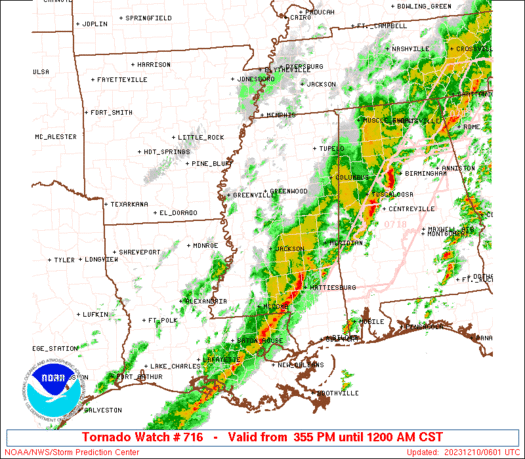
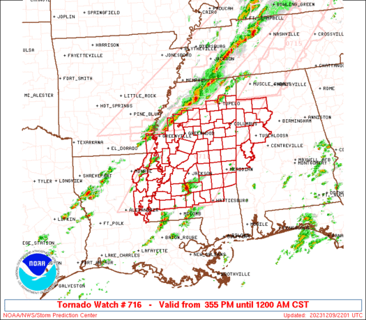
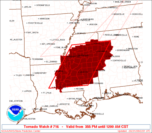
Tornado Watch Number 716
NWS Storm Prediction Center Norman OK
355 PM CST Sat Dec 9 2023
The NWS Storm Prediction Center has issued a
* Tornado Watch for portions of
Western Alabama
Southeast Arkansas
Northeast Louisiana
Mississippi
* Effective this Saturday afternoon from 355 PM until Midnight
CST.
* Primary threats include...
A few tornadoes possible
Scattered damaging wind gusts to 70 mph possible
Isolated large hail events to 1.5 inches in diameter possible
SUMMARY...Severe storm risk including the potential for damaging
winds and some tornadoes will increase through the evening, with the
risk potentially continuing into the overnight.
The tornado watch area is approximately along and 95 statute miles
east and west of a line from Tupelo MS to 25 miles southeast of
Natchez MS. For a complete depiction of the watch see the associated
watch outline update (WOUS64 KWNS WOU6).
PRECAUTIONARY/PREPAREDNESS ACTIONS...
REMEMBER...A Tornado Watch means conditions are favorable for
tornadoes and severe thunderstorms in and close to the watch
area. Persons in these areas should be on the lookout for
threatening weather conditions and listen for later statements
and possible warnings.
&&
OTHER WATCH INFORMATION...CONTINUE...WW 714...WW 715...
AVIATION...Tornadoes and a few severe thunderstorms with hail
surface and aloft to 1.5 inches. Extreme turbulence and surface wind
gusts to 60 knots. A few cumulonimbi with maximum tops to 500. Mean
storm motion vector 24035.
...Guyer
   SEL6

   URGENT - IMMEDIATE BROADCAST REQUESTED
   Tornado Watch Number 716
   NWS Storm Prediction Center Norman OK
   355 PM CST Sat Dec 9 2023

   The NWS Storm Prediction Center has issued a

   * Tornado Watch for portions of
     Western Alabama
     Southeast Arkansas
     Northeast Louisiana
     Mississippi

   * Effective this Saturday afternoon from 355 PM until Midnight
     CST.

   * Primary threats include...
     A few tornadoes possible
     Scattered damaging wind gusts to 70 mph possible
     Isolated large hail events to 1.5 inches in diameter possible

   SUMMARY...Severe storm risk including the potential for damaging
   winds and some tornadoes will increase through the evening, with the
   risk potentially continuing into the overnight.

   The tornado watch area is approximately along and 95 statute miles
   east and west of a line from Tupelo MS to 25 miles southeast of
   Natchez MS. For a complete depiction of the watch see the associated
   watch outline update (WOUS64 KWNS WOU6).

   PRECAUTIONARY/PREPAREDNESS ACTIONS...

   REMEMBER...A Tornado Watch means conditions are favorable for
   tornadoes and severe thunderstorms in and close to the watch
   area. Persons in these areas should be on the lookout for
   threatening weather conditions and listen for later statements
   and possible warnings.

   &&

   OTHER WATCH INFORMATION...CONTINUE...WW 714...WW 715...

   AVIATION...Tornadoes and a few severe thunderstorms with hail
   surface and aloft to 1.5 inches. Extreme turbulence and surface wind
   gusts to 60 knots. A few cumulonimbi with maximum tops to 500. Mean
   storm motion vector 24035.

   ...Guyer
 Note:
The Aviation Watch (SAW) product is an approximation to the watch area.
The actual watch is depicted by the shaded areas.
Note:
The Aviation Watch (SAW) product is an approximation to the watch area.
The actual watch is depicted by the shaded areas.
   SAW6
   WW 716 TORNADO AL AR LA MS 092155Z - 100600Z
   AXIS..95 STATUTE MILES EAST AND WEST OF LINE..
   TUP/TUPELO MS/ - 25SE HEZ/NATCHEZ MS/
   ..AVIATION COORDS.. 80NM E/W /49NNW IGB - 38W MCB/
   HAIL SURFACE AND ALOFT..1.5 INCHES. WIND GUSTS..60 KNOTS.
   MAX TOPS TO 500. MEAN STORM MOTION VECTOR 24035.

   LAT...LON 34258711 31358939 31359261 34259043

   THIS IS AN APPROXIMATION TO THE WATCH AREA.  FOR A
   COMPLETE DEPICTION OF THE WATCH SEE WOUS64 KWNS
   FOR WOU6.
Watch 716 Status Report Messages:
STATUS REPORT #4 ON WW 716

VALID 100310Z - 100440Z

SEVERE WEATHER THREAT CONTINUES RIGHT OF A LINE FROM 20 ESE ESF
TO 20 WSW HEZ TO 20 NE HEZ TO 70 NE HEZ TO 55 SSE GWO TO 45 WSW
CBM TO 25 WSW CBM TO 35 NE CBM TO 25 SSW MSL.

FOR ADDITIONAL INFORMATION SEE MESOSCALE DISCUSSION 2315

..WENDT..12/10/23

ATTN...WFO...BMX...JAN...MEG...

&&

STATUS REPORT FOR WT 716

SEVERE WEATHER THREAT CONTINUES FOR THE FOLLOWING AREAS

ALC057-063-075-093-107-119-125-127-133-100440-

AL
.    ALABAMA COUNTIES INCLUDED ARE

FAYETTE 	     GREENE		 LAMAR
MARION		     PICKENS		 SUMTER
TUSCALOOSA	     WALKER		 WINSTON
$$


MSC001-023-025-029-031-037-049-061-063-065-067-069-075-077-079-
085-087-099-101-103-105-121-123-127-129-159-100440-

MS
.    MISSISSIPPI COUNTIES INCLUDED ARE

ADAMS		     CLARKE		 CLAY
COPIAH		     COVINGTON		 FRANKLIN
HINDS		     JASPER		 JEFFERSON
JEFFERSON DAVIS      JONES		 KEMPER
LAUDERDALE	     LAWRENCE		 LEAKE
LINCOLN 	     LOWNDES		 NESHOBA
NEWTON		     NOXUBEE		 OKTIBBEHA
RANKIN		     SCOTT		 SIMPSON
SMITH		     WINSTON
$$


THE WATCH STATUS MESSAGE IS FOR GUIDANCE PURPOSES ONLY.  PLEASE
REFER TO WATCH COUNTY NOTIFICATION STATEMENTS FOR OFFICIAL
INFORMATION ON COUNTIES...INDEPENDENT CITIES AND MARINE ZONES
CLEARED FROM SEVERE THUNDERSTORM AND TORNADO WATCHES.
$$

STATUS REPORT #3 ON WW 716

VALID 100150Z - 100240Z

SEVERE WEATHER THREAT CONTINUES RIGHT OF A LINE FROM 20 WNW ESF
TO 35 NW HEZ TO 55 E MLU TO 35 SSW GWO TO 20 ESE GWO TO 40 SSW
TUP TO 20 S TUP TO 25 ENE TUP.

..WENDT..12/10/23

ATTN...WFO...BMX...JAN...MEG...

&&

STATUS REPORT FOR WT 716

SEVERE WEATHER THREAT CONTINUES FOR THE FOLLOWING AREAS

ALC057-063-075-093-107-119-125-127-133-100240-

AL
.    ALABAMA COUNTIES INCLUDED ARE

FAYETTE 	     GREENE		 LAMAR
MARION		     PICKENS		 SUMTER
TUSCALOOSA	     WALKER		 WINSTON
$$


LAC025-029-107-100240-

LA
.    LOUISIANA PARISHES INCLUDED ARE

CATAHOULA	     CONCORDIA		 TENSAS
$$


MSC001-007-017-019-021-023-025-029-031-037-049-051-057-061-063-
065-067-069-075-077-079-085-087-089-095-097-099-101-103-105-121-
123-127-129-149-155-159-163-100240-

MS
.    MISSISSIPPI COUNTIES INCLUDED ARE

ADAMS		     ATTALA		 CHICKASAW
CHOCTAW 	     CLAIBORNE		 CLARKE
CLAY		     COPIAH		 COVINGTON
FRANKLIN	     HINDS		 HOLMES
ITAWAMBA	     JASPER		 JEFFERSON
JEFFERSON DAVIS      JONES		 KEMPER
LAUDERDALE	     LAWRENCE		 LEAKE
LINCOLN 	     LOWNDES		 MADISON
MONROE		     MONTGOMERY 	 NESHOBA
NEWTON		     NOXUBEE		 OKTIBBEHA
RANKIN		     SCOTT		 SIMPSON
SMITH		     WARREN		 WEBSTER
WINSTON 	     YAZOO
$$


THE WATCH STATUS MESSAGE IS FOR GUIDANCE PURPOSES ONLY.  PLEASE
REFER TO WATCH COUNTY NOTIFICATION STATEMENTS FOR OFFICIAL
INFORMATION ON COUNTIES...INDEPENDENT CITIES AND MARINE ZONES
CLEARED FROM SEVERE THUNDERSTORM AND TORNADO WATCHES.
$$

STATUS REPORT #2 ON WW 716

VALID 100025Z - 100140Z

SEVERE WEATHER THREAT CONTINUES RIGHT OF A LINE FROM 40 SSE LLQ
TO 20 SSE GLH TO 10 NE GWO TO 20 SE UOX TO 20 E UOX.

FOR ADDITIONAL INFORMATION SEE MESOSCALE DISCUSSION 2311

..WENDT..12/10/23

ATTN...WFO...BMX...JAN...MEG...

&&

STATUS REPORT FOR WT 716

SEVERE WEATHER THREAT CONTINUES FOR THE FOLLOWING AREAS

ALC057-063-075-093-107-119-125-127-133-100140-

AL
.    ALABAMA COUNTIES INCLUDED ARE

FAYETTE 	     GREENE		 LAMAR
MARION		     PICKENS		 SUMTER
TUSCALOOSA	     WALKER		 WINSTON
$$


LAC025-029-035-041-065-083-107-123-100140-

LA
.    LOUISIANA PARISHES INCLUDED ARE

CATAHOULA	     CONCORDIA		 EAST CARROLL
FRANKLIN	     MADISON		 RICHLAND
TENSAS		     WEST CARROLL
$$


MSC001-007-013-015-017-019-021-023-025-029-031-037-049-051-053-
055-057-061-063-065-067-069-075-077-079-081-085-087-089-095-097-
099-101-103-105-115-121-123-125-127-129-149-155-159-163-
100140-

MS
.    MISSISSIPPI COUNTIES INCLUDED ARE

ADAMS		     ATTALA		 CALHOUN
CARROLL 	     CHICKASAW		 CHOCTAW
CLAIBORNE	     CLARKE		 CLAY
COPIAH		     COVINGTON		 FRANKLIN
HINDS		     HOLMES		 HUMPHREYS
ISSAQUENA	     ITAWAMBA		 JASPER
JEFFERSON	     JEFFERSON DAVIS	 JONES
KEMPER		     LAUDERDALE 	 LAWRENCE
LEAKE		     LEE		 LINCOLN
LOWNDES 	     MADISON		 MONROE
MONTGOMERY	     NESHOBA		 NEWTON
NOXUBEE 	     OKTIBBEHA		 PONTOTOC
RANKIN		     SCOTT		 SHARKEY
SIMPSON 	     SMITH		 WARREN
WEBSTER 	     WINSTON		 YAZOO
$$


THE WATCH STATUS MESSAGE IS FOR GUIDANCE PURPOSES ONLY.  PLEASE
REFER TO WATCH COUNTY NOTIFICATION STATEMENTS FOR OFFICIAL
INFORMATION ON COUNTIES...INDEPENDENT CITIES AND MARINE ZONES
CLEARED FROM SEVERE THUNDERSTORM AND TORNADO WATCHES.
$$

STATUS REPORT #1 ON WW 716

VALID 092245Z - 092340Z

THE SEVERE WEATHER THREAT CONTINUES ACROSS THE ENTIRE WATCH AREA.

..SQUITIERI..12/09/23

ATTN...WFO...BMX...JAN...MEG...

&&

STATUS REPORT FOR WT 716

SEVERE WEATHER THREAT CONTINUES FOR THE FOLLOWING AREAS

ALC057-063-075-093-107-119-125-127-133-092340-

AL
.    ALABAMA COUNTIES INCLUDED ARE

FAYETTE 	     GREENE		 LAMAR
MARION		     PICKENS		 SUMTER
TUSCALOOSA	     WALKER		 WINSTON
$$


ARC017-092340-

AR
.    ARKANSAS COUNTIES INCLUDED ARE

CHICOT
$$


LAC025-029-035-041-065-083-107-123-092340-

LA
.    LOUISIANA PARISHES INCLUDED ARE

CATAHOULA	     CONCORDIA		 EAST CARROLL
FRANKLIN	     MADISON		 RICHLAND
TENSAS		     WEST CARROLL
$$


MSC001-007-013-015-017-019-021-023-025-029-031-037-043-049-051-
053-055-057-061-063-065-067-069-075-077-079-081-083-085-087-089-
095-097-099-101-103-105-115-121-123-125-127-129-133-135-149-151-
155-159-161-163-092340-

MS
.    MISSISSIPPI COUNTIES INCLUDED ARE

ADAMS		     ATTALA		 CALHOUN
CARROLL 	     CHICKASAW		 CHOCTAW
CLAIBORNE	     CLARKE		 CLAY
COPIAH		     COVINGTON		 FRANKLIN
GRENADA 	     HINDS		 HOLMES
HUMPHREYS	     ISSAQUENA		 ITAWAMBA
JASPER		     JEFFERSON		 JEFFERSON DAVIS
JONES		     KEMPER		 LAUDERDALE
LAWRENCE	     LEAKE		 LEE
LEFLORE 	     LINCOLN		 LOWNDES
MADISON 	     MONROE		 MONTGOMERY
NESHOBA 	     NEWTON		 NOXUBEE
OKTIBBEHA	     PONTOTOC		 RANKIN
SCOTT		     SHARKEY		 SIMPSON
SMITH		     SUNFLOWER		 TALLAHATCHIE
WARREN		     WASHINGTON 	 WEBSTER
WINSTON 	     YALOBUSHA		 YAZOO
$$


THE WATCH STATUS MESSAGE IS FOR GUIDANCE PURPOSES ONLY.  PLEASE
REFER TO WATCH COUNTY NOTIFICATION STATEMENTS FOR OFFICIAL
INFORMATION ON COUNTIES...INDEPENDENT CITIES AND MARINE ZONES
CLEARED FROM SEVERE THUNDERSTORM AND TORNADO WATCHES.
$$
Note:
Click for Complete Product Text.
Tornadoes
Probability of 2 or more tornadoes
|
Mod (50%)
|
Probability of 1 or more strong (EF2-EF5) tornadoes
|
Low (20%)
|
Wind
Probability of 10 or more severe wind events
|
Mod (50%)
|
Probability of 1 or more wind events > 65 knots
|
Low (20%)
|
Hail
Probability of 10 or more severe hail events
|
Mod (30%)
|
Probability of 1 or more hailstones > 2 inches
|
Low (20%)
|
Combined Severe Hail/Wind
Probability of 6 or more combined severe hail/wind events
|
High (80%)
|
For each watch, probabilities for particular events inside the watch
(listed above in each table) are determined by the issuing forecaster.
The "Low" category contains probability values ranging from less than 2%
to 20% (EF2-EF5 tornadoes), less than 5% to 20% (all other probabilities),
"Moderate" from 30% to 60%, and "High" from 70% to greater than 95%.
High values are bolded and lighter in color to provide awareness of
an increased threat for a particular event.


 @NWSSPC


