 Note:
The expiration time in the watch graphic is amended if the watch is
replaced, cancelled or extended.
Note:
Note:
The expiration time in the watch graphic is amended if the watch is
replaced, cancelled or extended.
Note: Click for
Watch Status Reports.
SEL0
URGENT - IMMEDIATE BROADCAST REQUESTED
Severe Thunderstorm Watch Number 70
NWS Storm Prediction Center Norman OK
835 PM CDT Mon Apr 1 2024
The NWS Storm Prediction Center has issued a
* Severe Thunderstorm Watch for portions of
Northwest Arkansas
Eastern Oklahoma
East Texas
* Effective this Monday night and Tuesday morning from 835 PM
until 100 AM CDT.
* Primary threats include...
Scattered damaging winds and isolated significant gusts to 75
mph likely
Scattered large hail and isolated very large hail events to 2
inches in diameter likely
A tornado or two possible
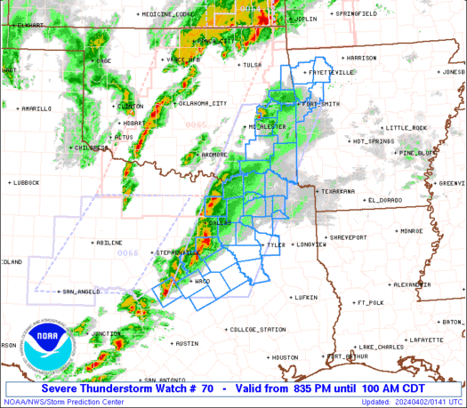
SUMMARY...A line of intense storms over east-central TX and eastern
Oklahoma will persist for a few more hours, posing a risk of
damaging wind gusts and large hail.
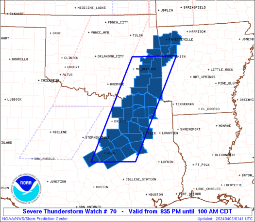
The severe thunderstorm watch area is approximately along and 60
statute miles east and west of a line from 25 miles north northwest
of Poteau OK to 35 miles southeast of Waco TX. For a complete
depiction of the watch see the associated watch outline update
(WOUS64 KWNS WOU0).
PRECAUTIONARY/PREPAREDNESS ACTIONS...
REMEMBER...A Severe Thunderstorm Watch means conditions are
favorable for severe thunderstorms in and close to the watch area.
Persons in these areas should be on the lookout for threatening
weather conditions and listen for later statements and possible
warnings. Severe thunderstorms can and occasionally do produce
tornadoes.
&&
OTHER WATCH INFORMATION...CONTINUE...WW 64...WW 65...WW 66...WW
67...WW 68...WW 69...
AVIATION...A few severe thunderstorms with hail surface and aloft to
2 inches. Extreme turbulence and surface wind gusts to 65 knots. A
few cumulonimbi with maximum tops to 500. Mean storm motion vector
25030.
...Hart
   SEL0

   URGENT - IMMEDIATE BROADCAST REQUESTED
   Severe Thunderstorm Watch Number 70
   NWS Storm Prediction Center Norman OK
   835 PM CDT Mon Apr 1 2024

   The NWS Storm Prediction Center has issued a

   * Severe Thunderstorm Watch for portions of
     Northwest Arkansas
     Eastern Oklahoma
     East Texas

   * Effective this Monday night and Tuesday morning from 835 PM
     until 100 AM CDT.

   * Primary threats include...
     Scattered damaging winds and isolated significant gusts to 75
       mph likely
     Scattered large hail and isolated very large hail events to 2
       inches in diameter likely
     A tornado or two possible

   SUMMARY...A line of intense storms over east-central TX and eastern
   Oklahoma will persist for a few more hours, posing a risk of
   damaging wind gusts and large hail.

   The severe thunderstorm watch area is approximately along and 60
   statute miles east and west of a line from 25 miles north northwest
   of Poteau OK to 35 miles southeast of Waco TX. For a complete
   depiction of the watch see the associated watch outline update
   (WOUS64 KWNS WOU0).

   PRECAUTIONARY/PREPAREDNESS ACTIONS...

   REMEMBER...A Severe Thunderstorm Watch means conditions are
   favorable for severe thunderstorms in and close to the watch area.
   Persons in these areas should be on the lookout for threatening
   weather conditions and listen for later statements and possible
   warnings. Severe thunderstorms can and occasionally do produce
   tornadoes.

   &&

   OTHER WATCH INFORMATION...CONTINUE...WW 64...WW 65...WW 66...WW
   67...WW 68...WW 69...

   AVIATION...A few severe thunderstorms with hail surface and aloft to
   2 inches. Extreme turbulence and surface wind gusts to 65 knots. A
   few cumulonimbi with maximum tops to 500. Mean storm motion vector
   25030.

   ...Hart
 Note:
The Aviation Watch (SAW) product is an approximation to the watch area.
The actual watch is depicted by the shaded areas.
Note:
The Aviation Watch (SAW) product is an approximation to the watch area.
The actual watch is depicted by the shaded areas.
   SAW0
   WW 70 SEVERE TSTM AR OK TX 020135Z - 020600Z
   AXIS..60 STATUTE MILES EAST AND WEST OF LINE..
   25NNW RKR/POTEAU OK/ - 35SE ACT/WACO TX/
   ..AVIATION COORDS.. 50NM E/W /25W FSM - 34SE ACT/
   HAIL SURFACE AND ALOFT..2 INCHES. WIND GUSTS..65 KNOTS.
   MAX TOPS TO 500. MEAN STORM MOTION VECTOR 25030.

   LAT...LON 35349373 31269580 31269783 35349585

   THIS IS AN APPROXIMATION TO THE WATCH AREA.  FOR A
   COMPLETE DEPICTION OF THE WATCH SEE WOUS64 KWNS
   FOR WOU0.
Watch 70 Status Report Messages:
STATUS REPORT #2 ON WW 70

VALID 020350Z - 020440Z

SEVERE WEATHER THREAT CONTINUES RIGHT OF A LINE FROM 45 N GGG TO
45 SSW PRX TO 25 SW GYI.

FOR ADDITIONAL INFORMATION SEE MESOSCALE DISCUSSION 335

..SQUITIERI..04/02/24

ATTN...WFO...TSA...SHV...FWD...

&&

STATUS REPORT FOR WS 70

SEVERE WEATHER THREAT CONTINUES FOR THE FOLLOWING AREAS

ARC033-047-087-131-143-020440-

AR
.    ARKANSAS COUNTIES INCLUDED ARE

CRAWFORD	     FRANKLIN		 MADISON
SEBASTIAN	     WASHINGTON
$$


OKC001-023-061-077-079-089-127-135-020440-

OK
.    OKLAHOMA COUNTIES INCLUDED ARE

ADAIR		     CHOCTAW		 HASKELL
LATIMER 	     LE FLORE		 MCCURTAIN
PUSHMATAHA	     SEQUOYAH
$$


TXC063-085-119-147-159-223-231-277-387-449-020440-

TX
.    TEXAS COUNTIES INCLUDED ARE

CAMP		     COLLIN		 DELTA
FANNIN		     FRANKLIN		 HOPKINS
HUNT		     LAMAR		 RED RIVER
TITUS
$$


THE WATCH STATUS MESSAGE IS FOR GUIDANCE PURPOSES ONLY.  PLEASE
REFER TO WATCH COUNTY NOTIFICATION STATEMENTS FOR OFFICIAL
INFORMATION ON COUNTIES...INDEPENDENT CITIES AND MARINE ZONES
CLEARED FROM SEVERE THUNDERSTORM AND TORNADO WATCHES.
$$

STATUS REPORT #1 ON WW 70

VALID 020325Z - 020440Z

THE SEVERE WEATHER THREAT CONTINUES ACROSS THE ENTIRE WATCH AREA.

..SQUITIERI..04/02/24

ATTN...WFO...TSA...SHV...FWD...

&&

STATUS REPORT FOR WS 70

SEVERE WEATHER THREAT CONTINUES FOR THE FOLLOWING AREAS

ARC033-047-087-131-143-020440-

AR
.    ARKANSAS COUNTIES INCLUDED ARE

CRAWFORD	     FRANKLIN		 MADISON
SEBASTIAN	     WASHINGTON
$$


OKC001-023-061-077-079-089-127-135-020440-

OK
.    OKLAHOMA COUNTIES INCLUDED ARE

ADAIR		     CHOCTAW		 HASKELL
LATIMER 	     LE FLORE		 MCCURTAIN
PUSHMATAHA	     SEQUOYAH
$$


TXC001-063-085-099-119-139-145-147-159-161-213-217-223-231-257-
277-293-309-349-379-387-397-423-449-467-499-020440-

TX
.    TEXAS COUNTIES INCLUDED ARE

ANDERSON	     CAMP		 COLLIN
CORYELL 	     DELTA		 ELLIS
FALLS		     FANNIN		 FRANKLIN
FREESTONE	     HENDERSON		 HILL
HOPKINS 	     HUNT		 KAUFMAN
LAMAR		     LIMESTONE		 MCLENNAN
NAVARRO 	     RAINS		 RED RIVER
ROCKWALL	     SMITH		 TITUS
VAN ZANDT	     WOOD
$$


THE WATCH STATUS MESSAGE IS FOR GUIDANCE PURPOSES ONLY.  PLEASE
REFER TO WATCH COUNTY NOTIFICATION STATEMENTS FOR OFFICIAL
INFORMATION ON COUNTIES...INDEPENDENT CITIES AND MARINE ZONES
CLEARED FROM SEVERE THUNDERSTORM AND TORNADO WATCHES.
$$
Note:
Click for Complete Product Text.
Tornadoes
Probability of 2 or more tornadoes
|
Low (20%)
|
Probability of 1 or more strong (EF2-EF5) tornadoes
|
Low (10%)
|
Wind
Probability of 10 or more severe wind events
|
High (70%)
|
Probability of 1 or more wind events > 65 knots
|
Mod (60%)
|
Hail
Probability of 10 or more severe hail events
|
Mod (60%)
|
Probability of 1 or more hailstones > 2 inches
|
Mod (60%)
|
Combined Severe Hail/Wind
Probability of 6 or more combined severe hail/wind events
|
High (>95%)
|
For each watch, probabilities for particular events inside the watch
(listed above in each table) are determined by the issuing forecaster.
The "Low" category contains probability values ranging from less than 2%
to 20% (EF2-EF5 tornadoes), less than 5% to 20% (all other probabilities),
"Moderate" from 30% to 60%, and "High" from 70% to greater than 95%.
High values are bolded and lighter in color to provide awareness of
an increased threat for a particular event.


 @NWSSPC


