Note:
The expiration time in the watch graphic is amended if the watch is
replaced, cancelled or extended.
Note:
Note:
The expiration time in the watch graphic is amended if the watch is
replaced, cancelled or extended.
Note: Click for
Watch Status Reports.
SEL1
URGENT - IMMEDIATE BROADCAST REQUESTED
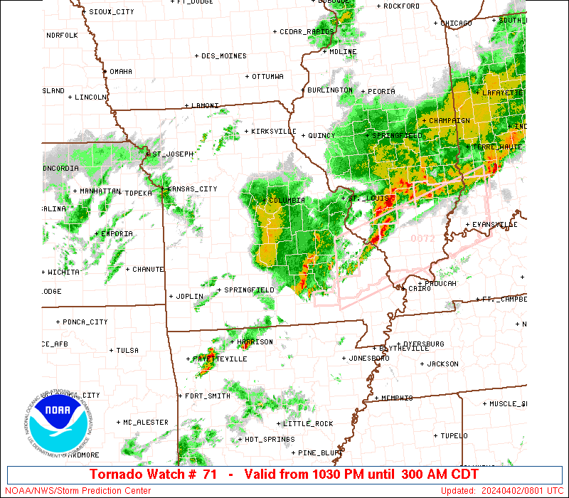
Tornado Watch Number 71
NWS Storm Prediction Center Norman OK
1030 PM CDT Mon Apr 1 2024
The NWS Storm Prediction Center has issued a
* Tornado Watch for portions of
Central Illinois
Southwest into East-Central Missouri
* Effective this Monday night and Tuesday morning from 1030 PM
until 300 AM CDT.
* Primary threats include...
A few tornadoes and a couple intense tornadoes possible
Widespread damaging winds and isolated significant gusts to 75
mph likely
Scattered large hail and isolated very large hail events to 2
inches in diameter likely
SUMMARY...Multiple clusters of strong/severe thunderstorms will
track east-northeastward across the watch area through the night,
posing a risk of locally damaging wind gusts, large hail, and a few
tornadoes.
The tornado watch area is approximately along and 40 statute miles
north and south of a line from 10 miles north northwest of Monett MO
to 20 miles north of Salem IL. For a complete depiction of the watch
see the associated watch outline update (WOUS64 KWNS WOU1).
PRECAUTIONARY/PREPAREDNESS ACTIONS...
REMEMBER...A Tornado Watch means conditions are favorable for
tornadoes and severe thunderstorms in and close to the watch
area. Persons in these areas should be on the lookout for
threatening weather conditions and listen for later statements
and possible warnings.
&&
OTHER WATCH INFORMATION...CONTINUE...WW 67...WW 68...WW 69...WW
70...
AVIATION...Tornadoes and a few severe thunderstorms with hail
surface and aloft to 2 inches. Extreme turbulence and surface wind
gusts to 65 knots. A few cumulonimbi with maximum tops to 500. Mean
storm motion vector 25035.
...Hart
   SEL1

   URGENT - IMMEDIATE BROADCAST REQUESTED
   Tornado Watch Number 71
   NWS Storm Prediction Center Norman OK
   1030 PM CDT Mon Apr 1 2024

   The NWS Storm Prediction Center has issued a

   * Tornado Watch for portions of
     Central Illinois
     Southwest into East-Central Missouri

   * Effective this Monday night and Tuesday morning from 1030 PM
     until 300 AM CDT.

   * Primary threats include...
     A few tornadoes and a couple intense tornadoes possible
     Widespread damaging winds and isolated significant gusts to 75
       mph likely
     Scattered large hail and isolated very large hail events to 2
       inches in diameter likely

   SUMMARY...Multiple clusters of strong/severe thunderstorms will
   track east-northeastward across the watch area through the night,
   posing a risk of locally damaging wind gusts, large hail, and a few
   tornadoes.

   The tornado watch area is approximately along and 40 statute miles
   north and south of a line from 10 miles north northwest of Monett MO
   to 20 miles north of Salem IL. For a complete depiction of the watch
   see the associated watch outline update (WOUS64 KWNS WOU1).

   PRECAUTIONARY/PREPAREDNESS ACTIONS...

   REMEMBER...A Tornado Watch means conditions are favorable for
   tornadoes and severe thunderstorms in and close to the watch
   area. Persons in these areas should be on the lookout for
   threatening weather conditions and listen for later statements
   and possible warnings.

   &&

   OTHER WATCH INFORMATION...CONTINUE...WW 67...WW 68...WW 69...WW
   70...

   AVIATION...Tornadoes and a few severe thunderstorms with hail
   surface and aloft to 2 inches. Extreme turbulence and surface wind
   gusts to 65 knots. A few cumulonimbi with maximum tops to 500. Mean
   storm motion vector 25035.

   ...Hart
 Note:
The Aviation Watch (SAW) product is an approximation to the watch area.
The actual watch is depicted by the shaded areas.
Note:
The Aviation Watch (SAW) product is an approximation to the watch area.
The actual watch is depicted by the shaded areas.
SAW1
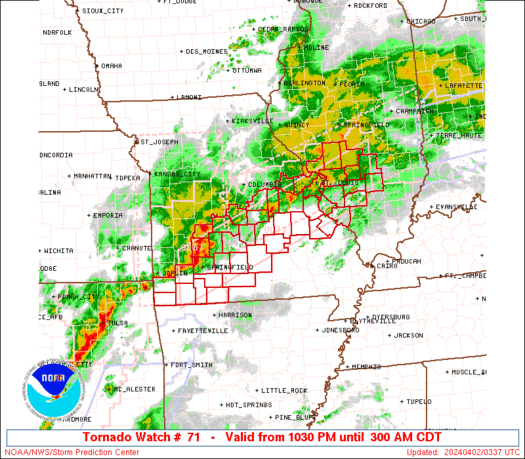
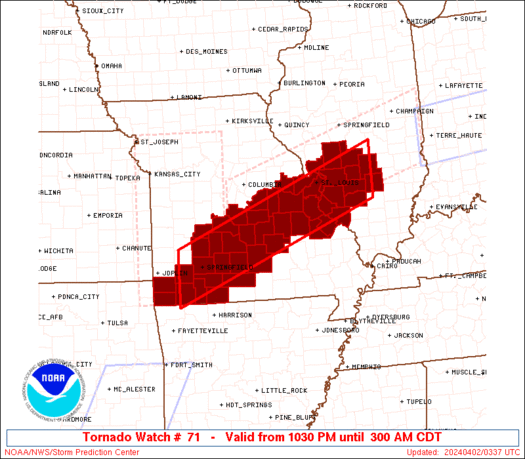
WW 71 TORNADO IL MO 020330Z - 020800Z
AXIS..40 STATUTE MILES NORTH AND SOUTH OF LINE..
10NNW UMN/MONETT MO/ - 20N SLO/SALEM IL/
..AVIATION COORDS.. 35NM N/S /37SW SGF - 48S AXC/
HAIL SURFACE AND ALOFT..2 INCHES. WIND GUSTS..65 KNOTS.
MAX TOPS TO 500. MEAN STORM MOTION VECTOR 25035.
LAT...LON 37599397 39528897 38368897 36439397
THIS IS AN APPROXIMATION TO THE WATCH AREA. FOR A
COMPLETE DEPICTION OF THE WATCH SEE WOUS64 KWNS
FOR WOU1.
Watch 71 Status Report Messages:
STATUS REPORT #2 ON WW 71

VALID 020545Z - 020640Z

SEVERE WEATHER THREAT CONTINUES RIGHT OF A LINE FROM 30 NNE FYV
TO 5 NW UMN TO 5 N SGF TO 20 WSW TBN TO 20 N TBN TO 10 ESE JEF.

..LEITMAN..04/02/24

ATTN...WFO...LSX...SGF...

&&

STATUS REPORT FOR WT 71

SEVERE WEATHER THREAT CONTINUES FOR THE FOLLOWING AREAS

ILC005-027-051-083-117-119-121-133-135-157-163-189-020640-

IL
.    ILLINOIS COUNTIES INCLUDED ARE

BOND		     CLINTON		 FAYETTE
JERSEY		     MACOUPIN		 MADISON
MARION		     MONROE		 MONTGOMERY
RANDOLPH	     ST. CLAIR		 WASHINGTON
$$


MOC009-043-055-065-067-071-073-093-099-123-125-151-161-169-179-
183-186-187-189-209-213-215-219-221-225-229-510-020640-

MO
.    MISSOURI COUNTIES INCLUDED ARE

BARRY		     CHRISTIAN		 CRAWFORD
DENT		     DOUGLAS		 FRANKLIN
GASCONADE	     IRON		 JEFFERSON
MADISON 	     MARIES		 OSAGE
PHELPS		     PULASKI		 REYNOLDS
ST. CHARLES	     STE. GENEVIEVE	 ST. FRANCOIS
ST. LOUIS	     STONE		 TANEY
TEXAS		     WARREN		 WASHINGTON
WEBSTER 	     WRIGHT


MISSOURI INDEPENDENT CITIES INCLUDED ARE

ST. LOUIS CITY
$$


THE WATCH STATUS MESSAGE IS FOR GUIDANCE PURPOSES ONLY.  PLEASE
REFER TO WATCH COUNTY NOTIFICATION STATEMENTS FOR OFFICIAL
INFORMATION ON COUNTIES...INDEPENDENT CITIES AND MARINE ZONES
CLEARED FROM SEVERE THUNDERSTORM AND TORNADO WATCHES.
$$

STATUS REPORT #1 ON WW 71

VALID 020435Z - 020540Z

SEVERE WEATHER THREAT CONTINUES RIGHT OF A LINE FROM 30 ENE JLN
TO 40 NE SGF TO 30 SW JEF.

FOR ADDITIONAL INFORMATION SEE MESOSCALE DISCUSSION 336

..SQUITIERI..04/02/24

ATTN...WFO...LSX...SGF...

&&

STATUS REPORT FOR WT 71

SEVERE WEATHER THREAT CONTINUES FOR THE FOLLOWING AREAS

ILC005-027-051-083-117-119-121-133-135-157-163-189-020540-

IL
.    ILLINOIS COUNTIES INCLUDED ARE

BOND		     CLINTON		 FAYETTE
JERSEY		     MACOUPIN		 MADISON
MARION		     MONROE		 MONTGOMERY
RANDOLPH	     ST. CLAIR		 WASHINGTON
$$


MOC009-043-055-065-067-071-073-077-099-105-109-119-125-131-145-
151-161-169-183-186-187-189-209-213-215-219-221-225-229-510-
020540-

MO
.    MISSOURI COUNTIES INCLUDED ARE

BARRY		     CHRISTIAN		 CRAWFORD
DENT		     DOUGLAS		 FRANKLIN
GASCONADE	     GREENE		 JEFFERSON
LACLEDE 	     LAWRENCE		 MCDONALD
MARIES		     MILLER		 NEWTON
OSAGE		     PHELPS		 PULASKI
ST. CHARLES	     STE. GENEVIEVE	 ST. FRANCOIS
ST. LOUIS	     STONE		 TANEY
TEXAS		     WARREN		 WASHINGTON
WEBSTER 	     WRIGHT


MISSOURI INDEPENDENT CITIES INCLUDED ARE

ST. LOUIS CITY
$$


THE WATCH STATUS MESSAGE IS FOR GUIDANCE PURPOSES ONLY.  PLEASE
REFER TO WATCH COUNTY NOTIFICATION STATEMENTS FOR OFFICIAL
INFORMATION ON COUNTIES...INDEPENDENT CITIES AND MARINE ZONES
CLEARED FROM SEVERE THUNDERSTORM AND TORNADO WATCHES.
$$
Note:
Click for Complete Product Text.
Tornadoes
Probability of 2 or more tornadoes
|
Mod (50%)
|
Probability of 1 or more strong (EF2-EF5) tornadoes
|
Mod (40%)
|
Wind
Probability of 10 or more severe wind events
|
High (80%)
|
Probability of 1 or more wind events > 65 knots
|
High (70%)
|
Hail
Probability of 10 or more severe hail events
|
Mod (60%)
|
Probability of 1 or more hailstones > 2 inches
|
Mod (60%)
|
Combined Severe Hail/Wind
Probability of 6 or more combined severe hail/wind events
|
High (>95%)
|
For each watch, probabilities for particular events inside the watch
(listed above in each table) are determined by the issuing forecaster.
The "Low" category contains probability values ranging from less than 2%
to 20% (EF2-EF5 tornadoes), less than 5% to 20% (all other probabilities),
"Moderate" from 30% to 60%, and "High" from 70% to greater than 95%.
High values are bolded and lighter in color to provide awareness of
an increased threat for a particular event.


 @NWSSPC