 Note:
The expiration time in the watch graphic is amended if the watch is
replaced, cancelled or extended.
Note:
Note:
The expiration time in the watch graphic is amended if the watch is
replaced, cancelled or extended.
Note: Click for
Watch Status Reports.
SEL8
URGENT - IMMEDIATE BROADCAST REQUESTED
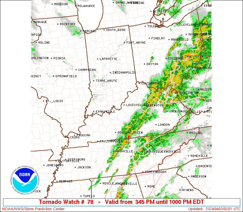
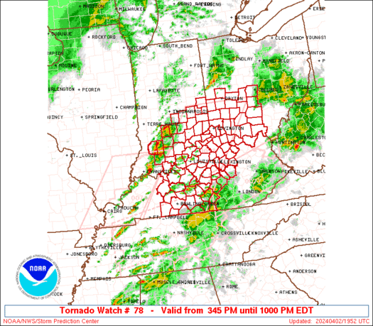
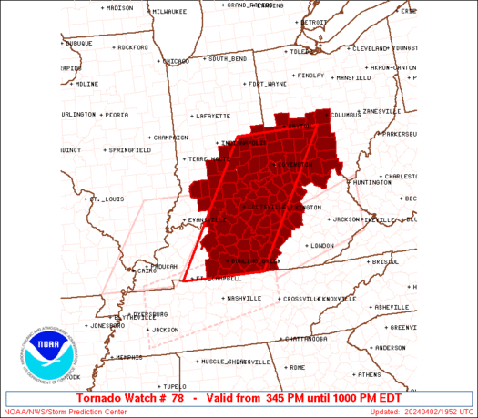
Tornado Watch Number 78
NWS Storm Prediction Center Norman OK
345 PM EDT Tue Apr 2 2024
The NWS Storm Prediction Center has issued a
* Tornado Watch for portions of
Southeast Indiana
Central Kentucky
Southwest Ohio
* Effective this Tuesday afternoon and evening from 345 PM until
1000 PM EDT.
* Primary threats include...
A few tornadoes likely with a couple intense tornadoes possible
Scattered damaging winds likely with isolated significant gusts
to 75 mph possible
Scattered large hail likely with isolated very large hail events
to 2 inches in diameter possible
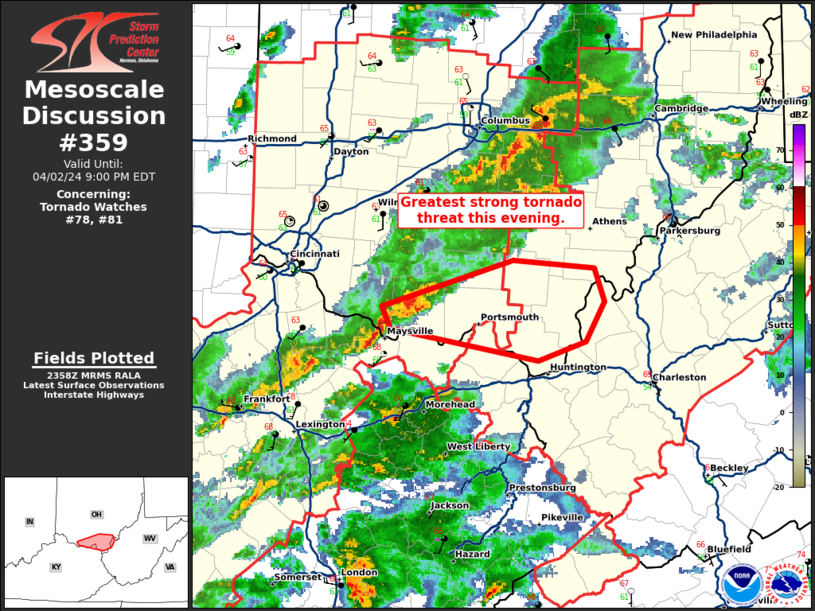
SUMMARY...Supercells are expected to form and intensify through the
afternoon from Kentucky into southeast Indiana and eventually
southwest Ohio. The storm environment favors the potential for a
couple of strong tornadoes (EF2+), large hail of 1-2 inches in
diameter, and occasional damaging gusts of 60-75 mph.
The tornado watch area is approximately along and 65 statute miles
east and west of a line from 50 miles north of Cincinnati OH to 25
miles south southwest of Bowling Green KY. For a complete depiction
of the watch see the associated watch outline update (WOUS64 KWNS
WOU8).
PRECAUTIONARY/PREPAREDNESS ACTIONS...
REMEMBER...A Tornado Watch means conditions are favorable for
tornadoes and severe thunderstorms in and close to the watch
area. Persons in these areas should be on the lookout for
threatening weather conditions and listen for later statements
and possible warnings.
&&
OTHER WATCH INFORMATION...CONTINUE...WW 75...WW 76...WW 77...
AVIATION...Tornadoes and a few severe thunderstorms with hail
surface and aloft to 2 inches. Extreme turbulence and surface wind
gusts to 65 knots. A few cumulonimbi with maximum tops to 500. Mean
storm motion vector 24050.
...Thompson

   SEL8

   URGENT - IMMEDIATE BROADCAST REQUESTED
   Tornado Watch Number 78
   NWS Storm Prediction Center Norman OK
   345 PM EDT Tue Apr 2 2024

   The NWS Storm Prediction Center has issued a

   * Tornado Watch for portions of
     Southeast Indiana
     Central Kentucky
     Southwest Ohio

   * Effective this Tuesday afternoon and evening from 345 PM until
     1000 PM EDT.

   * Primary threats include...
     A few tornadoes likely with a couple intense tornadoes possible
     Scattered damaging winds likely with isolated significant gusts
       to 75 mph possible
     Scattered large hail likely with isolated very large hail events
       to 2 inches in diameter possible

   SUMMARY...Supercells are expected to form and intensify through the
   afternoon from Kentucky into southeast Indiana and eventually
   southwest Ohio.  The storm environment favors the potential for a
   couple of strong tornadoes (EF2+), large hail of 1-2 inches in
   diameter, and occasional damaging gusts of 60-75 mph.

   The tornado watch area is approximately along and 65 statute miles
   east and west of a line from 50 miles north of Cincinnati OH to 25
   miles south southwest of Bowling Green KY. For a complete depiction
   of the watch see the associated watch outline update (WOUS64 KWNS
   WOU8).

   PRECAUTIONARY/PREPAREDNESS ACTIONS...

   REMEMBER...A Tornado Watch means conditions are favorable for
   tornadoes and severe thunderstorms in and close to the watch
   area. Persons in these areas should be on the lookout for
   threatening weather conditions and listen for later statements
   and possible warnings.

   &&

   OTHER WATCH INFORMATION...CONTINUE...WW 75...WW 76...WW 77...

   AVIATION...Tornadoes and a few severe thunderstorms with hail
   surface and aloft to 2 inches. Extreme turbulence and surface wind
   gusts to 65 knots. A few cumulonimbi with maximum tops to 500. Mean
   storm motion vector 24050.

   ...Thompson
 Note:
The Aviation Watch (SAW) product is an approximation to the watch area.
The actual watch is depicted by the shaded areas.
Note:
The Aviation Watch (SAW) product is an approximation to the watch area.
The actual watch is depicted by the shaded areas.
   SAW8
   WW 78 TORNADO IN KY OH 021945Z - 030200Z
   AXIS..65 STATUTE MILES EAST AND WEST OF LINE..
   50N LUK/CINCINNATI OH/ - 25SSW BWG/BOWLING GREEN KY/
   ..AVIATION COORDS.. 55NM E/W /33SSW ROD - 19SSW BWG/
   HAIL SURFACE AND ALOFT..2 INCHES. WIND GUSTS..65 KNOTS.
   MAX TOPS TO 500. MEAN STORM MOTION VECTOR 24050.

   LAT...LON 39828320 36638542 36638776 39828564

   THIS IS AN APPROXIMATION TO THE WATCH AREA.  FOR A
   COMPLETE DEPICTION OF THE WATCH SEE WOUS64 KWNS
   FOR WOU8.
Watch 78 Status Report Messages:
STATUS REPORT #6 ON WW 78

VALID 030125Z - 030240Z

SEVERE WEATHER THREAT CONTINUES RIGHT OF A LINE FROM 30 NNE BNA
TO 40 E BWG TO 25 SW LEX TO 40 NNE LEX TO 50 E LUK.

..BENTLEY..04/03/24

ATTN...WFO...IND...LMK...ILN...

&&

STATUS REPORT FOR WT 78

SEVERE WEATHER THREAT CONTINUES FOR THE FOLLOWING AREAS

KYC001-003-009-017-021-023-045-049-053-057-067-079-097-113-135-
137-151-155-161-167-169-171-181-201-207-209-229-239-030240-

KY
.    KENTUCKY COUNTIES INCLUDED ARE

ADAIR		     ALLEN		 BARREN
BOURBON 	     BOYLE		 BRACKEN
CASEY		     CLARK		 CLINTON
CUMBERLAND	     FAYETTE		 GARRARD
HARRISON	     JESSAMINE		 LEWIS
LINCOLN 	     MADISON		 MARION
MASON		     MERCER		 METCALFE
MONROE		     NICHOLAS		 ROBERTSON
RUSSELL 	     SCOTT		 WASHINGTON
WOODFORD
$$


OHC001-015-073-131-141-145-030240-

OH
.    OHIO COUNTIES INCLUDED ARE

ADAMS		     BROWN		 HOCKING
PIKE		     ROSS		 SCIOTO
$$


THE WATCH STATUS MESSAGE IS FOR GUIDANCE PURPOSES ONLY.  PLEASE
REFER TO WATCH COUNTY NOTIFICATION STATEMENTS FOR OFFICIAL
INFORMATION ON COUNTIES...INDEPENDENT CITIES AND MARINE ZONES
CLEARED FROM SEVERE THUNDERSTORM AND TORNADO WATCHES.
$$

STATUS REPORT #5 ON WW 78

VALID 030030Z - 030140Z

SEVERE WEATHER THREAT CONTINUES RIGHT OF A LINE FROM 30 SW BWG TO
30 SSW SDF TO 35 N LEX TO 20 E LUK TO 30 NNW CMH.

..LYONS..04/03/24

ATTN...WFO...IND...LMK...ILN...

&&

STATUS REPORT FOR WT 78

SEVERE WEATHER THREAT CONTINUES FOR THE FOLLOWING AREAS

KYC001-003-005-009-017-021-023-045-049-053-057-061-067-073-079-
087-097-099-113-123-135-137-151-155-161-167-169-171-179-181-201-
207-209-213-217-227-229-239-030140-

KY
.    KENTUCKY COUNTIES INCLUDED ARE

ADAIR		     ALLEN		 ANDERSON
BARREN		     BOURBON		 BOYLE
BRACKEN 	     CASEY		 CLARK
CLINTON 	     CUMBERLAND 	 EDMONSON
FAYETTE 	     FRANKLIN		 GARRARD
GREEN		     HARRISON		 HART
JESSAMINE	     LARUE		 LEWIS
LINCOLN 	     MADISON		 MARION
MASON		     MERCER		 METCALFE
MONROE		     NELSON		 NICHOLAS
ROBERTSON	     RUSSELL		 SCOTT
SIMPSON 	     TAYLOR		 WARREN
WASHINGTON	     WOODFORD
$$


OHC001-015-041-045-047-049-071-073-089-097-129-131-141-145-
030140-

OH
.    OHIO COUNTIES INCLUDED ARE

ADAMS		     BROWN		 DELAWARE
FAIRFIELD	     FAYETTE		 FRANKLIN
HIGHLAND	     HOCKING		 LICKING
MADISON 	     PICKAWAY		 PIKE
ROSS		     SCIOTO
$$


THE WATCH STATUS MESSAGE IS FOR GUIDANCE PURPOSES ONLY.  PLEASE
REFER TO WATCH COUNTY NOTIFICATION STATEMENTS FOR OFFICIAL
INFORMATION ON COUNTIES...INDEPENDENT CITIES AND MARINE ZONES
CLEARED FROM SEVERE THUNDERSTORM AND TORNADO WATCHES.
$$

STATUS REPORT #4 ON WW 78

VALID 022335Z - 030040Z

SEVERE WEATHER THREAT CONTINUES RIGHT OF A LINE FROM 5 ENE CKV TO
35 E OWB TO 10 N SDF TO 40 WSW LUK TO 40 WNW LUK TO 25 S MIE.

..LYONS..04/02/24

ATTN...WFO...IND...LMK...ILN...

&&

STATUS REPORT FOR WT 78

SEVERE WEATHER THREAT CONTINUES FOR THE FOLLOWING AREAS

KYC001-003-005-009-015-017-021-023-029-031-037-041-045-049-053-
057-061-067-073-077-079-081-085-087-093-097-099-103-111-113-117-
123-135-137-141-151-155-161-163-167-169-171-179-181-185-187-191-
201-207-209-211-213-215-217-227-229-239-030040-

KY
.    KENTUCKY COUNTIES INCLUDED ARE

ADAIR		     ALLEN		 ANDERSON
BARREN		     BOONE		 BOURBON
BOYLE		     BRACKEN		 BULLITT
BUTLER		     CAMPBELL		 CARROLL
CASEY		     CLARK		 CLINTON
CUMBERLAND	     EDMONSON		 FAYETTE
FRANKLIN	     GALLATIN		 GARRARD
GRANT		     GRAYSON		 GREEN
HARDIN		     HARRISON		 HART
HENRY		     JEFFERSON		 JESSAMINE
KENTON		     LARUE		 LEWIS
LINCOLN 	     LOGAN		 MADISON
MARION		     MASON		 MEADE
MERCER		     METCALFE		 MONROE
NELSON		     NICHOLAS		 OLDHAM
OWEN		     PENDLETON		 ROBERTSON
RUSSELL 	     SCOTT		 SHELBY
SIMPSON 	     SPENCER		 TAYLOR
WARREN		     WASHINGTON 	 WOODFORD
$$


OHC001-015-017-021-023-025-027-037-041-045-047-049-057-061-071-
073-089-091-097-109-113-129-131-135-141-145-149-159-165-
030040-

OH
.    OHIO COUNTIES INCLUDED ARE

ADAMS		     BROWN		 BUTLER
CHAMPAIGN	     CLARK		 CLERMONT
CLINTON 	     DARKE		 DELAWARE
FAIRFIELD	     FAYETTE		 FRANKLIN
GREENE		     HAMILTON		 HIGHLAND
HOCKING 	     LICKING		 LOGAN
MADISON 	     MIAMI		 MONTGOMERY
PICKAWAY	     PIKE		 PREBLE
ROSS		     SCIOTO		 SHELBY
UNION		     WARREN
$$


THE WATCH STATUS MESSAGE IS FOR GUIDANCE PURPOSES ONLY.  PLEASE
REFER TO WATCH COUNTY NOTIFICATION STATEMENTS FOR OFFICIAL
INFORMATION ON COUNTIES...INDEPENDENT CITIES AND MARINE ZONES
CLEARED FROM SEVERE THUNDERSTORM AND TORNADO WATCHES.
$$

STATUS REPORT #3 ON WW 78

VALID 022220Z - 022340Z

SEVERE WEATHER THREAT CONTINUES RIGHT OF A LINE FROM 35 NE OWB TO
35 NNW SDF TO 55 N SDF TO 55 WNW LUK TO 30 SSW MIE.

..LYONS..04/02/24

ATTN...WFO...IND...LMK...ILN...

&&

STATUS REPORT FOR WT 78

SEVERE WEATHER THREAT CONTINUES FOR THE FOLLOWING AREAS

INC019-029-041-043-047-061-115-123-137-155-161-177-022340-

IN
.    INDIANA COUNTIES INCLUDED ARE

CLARK		     DEARBORN		 FAYETTE
FLOYD		     FRANKLIN		 HARRISON
OHIO		     PERRY		 RIPLEY
SWITZERLAND	     UNION		 WAYNE
$$


KYC001-003-005-009-015-017-021-023-027-029-031-037-041-045-049-
053-057-061-067-073-077-079-081-085-087-091-093-097-099-103-111-
113-117-123-135-137-141-151-155-161-163-167-169-171-179-181-183-
185-187-191-201-207-209-211-213-215-217-223-227-229-239-
022340-

KY
.    KENTUCKY COUNTIES INCLUDED ARE

ADAIR		     ALLEN		 ANDERSON
BARREN		     BOONE		 BOURBON
BOYLE		     BRACKEN		 BRECKINRIDGE
BULLITT 	     BUTLER		 CAMPBELL
CARROLL 	     CASEY		 CLARK
CLINTON 	     CUMBERLAND 	 EDMONSON
FAYETTE 	     FRANKLIN		 GALLATIN
GARRARD 	     GRANT		 GRAYSON
GREEN		     HANCOCK		 HARDIN
HARRISON	     HART		 HENRY
JEFFERSON	     JESSAMINE		 KENTON
LARUE		     LEWIS		 LINCOLN
LOGAN		     MADISON		 MARION
MASON		     MEADE		 MERCER
METCALFE	     MONROE		 NELSON
NICHOLAS	     OHIO		 OLDHAM
OWEN		     PENDLETON		 ROBERTSON
RUSSELL 	     SCOTT		 SHELBY
SIMPSON 	     SPENCER		 TAYLOR
TRIMBLE 	     WARREN		 WASHINGTON
WOODFORD
$$


OHC001-015-017-021-023-025-027-037-041-045-047-049-057-061-071-
073-089-091-097-109-113-129-131-135-141-145-149-159-165-
022340-

OH
.    OHIO COUNTIES INCLUDED ARE

ADAMS		     BROWN		 BUTLER
CHAMPAIGN	     CLARK		 CLERMONT
CLINTON 	     DARKE		 DELAWARE
FAIRFIELD	     FAYETTE		 FRANKLIN
GREENE		     HAMILTON		 HIGHLAND
HOCKING 	     LICKING		 LOGAN
MADISON 	     MIAMI		 MONTGOMERY
PICKAWAY	     PIKE		 PREBLE
ROSS		     SCIOTO		 SHELBY
UNION		     WARREN
$$


THE WATCH STATUS MESSAGE IS FOR GUIDANCE PURPOSES ONLY.  PLEASE
REFER TO WATCH COUNTY NOTIFICATION STATEMENTS FOR OFFICIAL
INFORMATION ON COUNTIES...INDEPENDENT CITIES AND MARINE ZONES
CLEARED FROM SEVERE THUNDERSTORM AND TORNADO WATCHES.
$$

STATUS REPORT #2 ON WW 78

VALID 022110Z - 022240Z

SEVERE WEATHER THREAT CONTINUES RIGHT OF A LINE FROM 30 ENE EVV
TO 40 S BMG TO 25 E BMG TO 10 S IND.

..LYONS..04/02/24

ATTN...WFO...IND...LMK...ILN...

&&

STATUS REPORT FOR WT 78

SEVERE WEATHER THREAT CONTINUES FOR THE FOLLOWING AREAS

INC005-013-019-025-029-031-041-043-047-061-071-077-079-081-115-
117-123-137-139-143-145-155-161-175-177-022240-

IN
.    INDIANA COUNTIES INCLUDED ARE

BARTHOLOMEW	     BROWN		 CLARK
CRAWFORD	     DEARBORN		 DECATUR
FAYETTE 	     FLOYD		 FRANKLIN
HARRISON	     JACKSON		 JEFFERSON
JENNINGS	     JOHNSON		 OHIO
ORANGE		     PERRY		 RIPLEY
RUSH		     SCOTT		 SHELBY
SWITZERLAND	     UNION		 WASHINGTON
WAYNE
$$


KYC001-003-005-009-015-017-021-023-027-029-031-037-041-045-049-
053-057-061-067-073-077-079-081-085-087-091-093-097-099-103-111-
113-117-123-135-137-141-151-155-161-163-167-169-171-179-181-183-
185-187-191-201-207-209-211-213-215-217-223-227-229-239-
022240-

KY
.    KENTUCKY COUNTIES INCLUDED ARE

ADAIR		     ALLEN		 ANDERSON
BARREN		     BOONE		 BOURBON
BOYLE		     BRACKEN		 BRECKINRIDGE
BULLITT 	     BUTLER		 CAMPBELL
CARROLL 	     CASEY		 CLARK
CLINTON 	     CUMBERLAND 	 EDMONSON
FAYETTE 	     FRANKLIN		 GALLATIN
GARRARD 	     GRANT		 GRAYSON
GREEN		     HANCOCK		 HARDIN
HARRISON	     HART		 HENRY
JEFFERSON	     JESSAMINE		 KENTON
LARUE		     LEWIS		 LINCOLN
LOGAN		     MADISON		 MARION
MASON		     MEADE		 MERCER
METCALFE	     MONROE		 NELSON
NICHOLAS	     OHIO		 OLDHAM
OWEN		     PENDLETON		 ROBERTSON
RUSSELL 	     SCOTT		 SHELBY
SIMPSON 	     SPENCER		 TAYLOR
TRIMBLE 	     WARREN		 WASHINGTON
WOODFORD
$$


OHC001-015-017-023-025-027-047-049-057-061-071-097-109-113-129-
131-135-141-145-165-022240-

OH
.    OHIO COUNTIES INCLUDED ARE

ADAMS		     BROWN		 BUTLER
CLARK		     CLERMONT		 CLINTON
FAYETTE 	     FRANKLIN		 GREENE
HAMILTON	     HIGHLAND		 MADISON
MIAMI		     MONTGOMERY 	 PICKAWAY
PIKE		     PREBLE		 ROSS
SCIOTO		     WARREN
$$


THE WATCH STATUS MESSAGE IS FOR GUIDANCE PURPOSES ONLY.  PLEASE
REFER TO WATCH COUNTY NOTIFICATION STATEMENTS FOR OFFICIAL
INFORMATION ON COUNTIES...INDEPENDENT CITIES AND MARINE ZONES
CLEARED FROM SEVERE THUNDERSTORM AND TORNADO WATCHES.
$$

STATUS REPORT #1 ON WW 78

VALID 022010Z - 022140Z

THE SEVERE WEATHER THREAT CONTINUES ACROSS THE ENTIRE WATCH AREA.

..LYONS..04/02/24

ATTN...WFO...IND...LMK...ILN...

&&

STATUS REPORT FOR WT 78

SEVERE WEATHER THREAT CONTINUES FOR THE FOLLOWING AREAS

INC005-013-019-025-027-029-031-037-041-043-047-061-071-077-079-
081-093-101-105-115-117-123-137-139-143-145-155-161-175-177-
022140-

IN
.    INDIANA COUNTIES INCLUDED ARE

BARTHOLOMEW	     BROWN		 CLARK
CRAWFORD	     DAVIESS		 DEARBORN
DECATUR 	     DUBOIS		 FAYETTE
FLOYD		     FRANKLIN		 HARRISON
JACKSON 	     JEFFERSON		 JENNINGS
JOHNSON 	     LAWRENCE		 MARTIN
MONROE		     OHIO		 ORANGE
PERRY		     RIPLEY		 RUSH
SCOTT		     SHELBY		 SWITZERLAND
UNION		     WASHINGTON 	 WAYNE
$$


KYC001-003-005-009-015-017-021-023-027-029-031-037-041-045-049-
053-057-061-067-073-077-079-081-085-087-091-093-097-099-103-111-
113-117-123-135-137-141-151-155-161-163-167-169-171-179-181-183-
185-187-191-201-207-209-211-213-215-217-223-227-229-239-
022140-

KY
.    KENTUCKY COUNTIES INCLUDED ARE

ADAIR		     ALLEN		 ANDERSON
BARREN		     BOONE		 BOURBON
BOYLE		     BRACKEN		 BRECKINRIDGE
BULLITT 	     BUTLER		 CAMPBELL
CARROLL 	     CASEY		 CLARK
CLINTON 	     CUMBERLAND 	 EDMONSON
FAYETTE 	     FRANKLIN		 GALLATIN
GARRARD 	     GRANT		 GRAYSON
GREEN		     HANCOCK		 HARDIN
HARRISON	     HART		 HENRY
JEFFERSON	     JESSAMINE		 KENTON
LARUE		     LEWIS		 LINCOLN
LOGAN		     MADISON		 MARION
MASON		     MEADE		 MERCER
METCALFE	     MONROE		 NELSON
NICHOLAS	     OHIO		 OLDHAM
OWEN		     PENDLETON		 ROBERTSON
RUSSELL 	     SCOTT		 SHELBY
SIMPSON 	     SPENCER		 TAYLOR
TRIMBLE 	     WARREN		 WASHINGTON
WOODFORD
$$


OHC001-015-017-023-025-027-047-049-057-061-071-097-109-113-129-
131-135-141-145-165-022140-

OH
.    OHIO COUNTIES INCLUDED ARE

ADAMS		     BROWN		 BUTLER
CLARK		     CLERMONT		 CLINTON
FAYETTE 	     FRANKLIN		 GREENE
HAMILTON	     HIGHLAND		 MADISON
MIAMI		     MONTGOMERY 	 PICKAWAY
PIKE		     PREBLE		 ROSS
SCIOTO		     WARREN
$$


THE WATCH STATUS MESSAGE IS FOR GUIDANCE PURPOSES ONLY.  PLEASE
REFER TO WATCH COUNTY NOTIFICATION STATEMENTS FOR OFFICIAL
INFORMATION ON COUNTIES...INDEPENDENT CITIES AND MARINE ZONES
CLEARED FROM SEVERE THUNDERSTORM AND TORNADO WATCHES.
$$
Note:
Click for Complete Product Text.
Tornadoes
Probability of 2 or more tornadoes
|
High (70%)
|
Probability of 1 or more strong (EF2-EF5) tornadoes
|
Mod (50%)
|
Wind
Probability of 10 or more severe wind events
|
High (70%)
|
Probability of 1 or more wind events > 65 knots
|
Mod (50%)
|
Hail
Probability of 10 or more severe hail events
|
High (70%)
|
Probability of 1 or more hailstones > 2 inches
|
Mod (50%)
|
Combined Severe Hail/Wind
Probability of 6 or more combined severe hail/wind events
|
High (>95%)
|
For each watch, probabilities for particular events inside the watch
(listed above in each table) are determined by the issuing forecaster.
The "Low" category contains probability values ranging from less than 2%
to 20% (EF2-EF5 tornadoes), less than 5% to 20% (all other probabilities),
"Moderate" from 30% to 60%, and "High" from 70% to greater than 95%.
High values are bolded and lighter in color to provide awareness of
an increased threat for a particular event.


 @NWSSPC