 Note:
The expiration time in the watch graphic is amended if the watch is
replaced, cancelled or extended.
Note:
Note:
The expiration time in the watch graphic is amended if the watch is
replaced, cancelled or extended.
Note: Click for
Watch Status Reports.
SEL9
URGENT - IMMEDIATE BROADCAST REQUESTED
Tornado Watch Number 199
NWS Storm Prediction Center Norman OK
915 PM EDT Tue May 7 2024
The NWS Storm Prediction Center has issued a
* Tornado Watch for portions of
Northeast Kentucky
Eastern Ohio
Northwest West Virginia
* Effective this Tuesday night and Wednesday morning from 915 PM
until 400 AM EDT.
* Primary threats include...
A few tornadoes likely
Scattered large hail and isolated very large hail events to 2
inches in diameter possible
Scattered damaging wind gusts to 70 mph possible
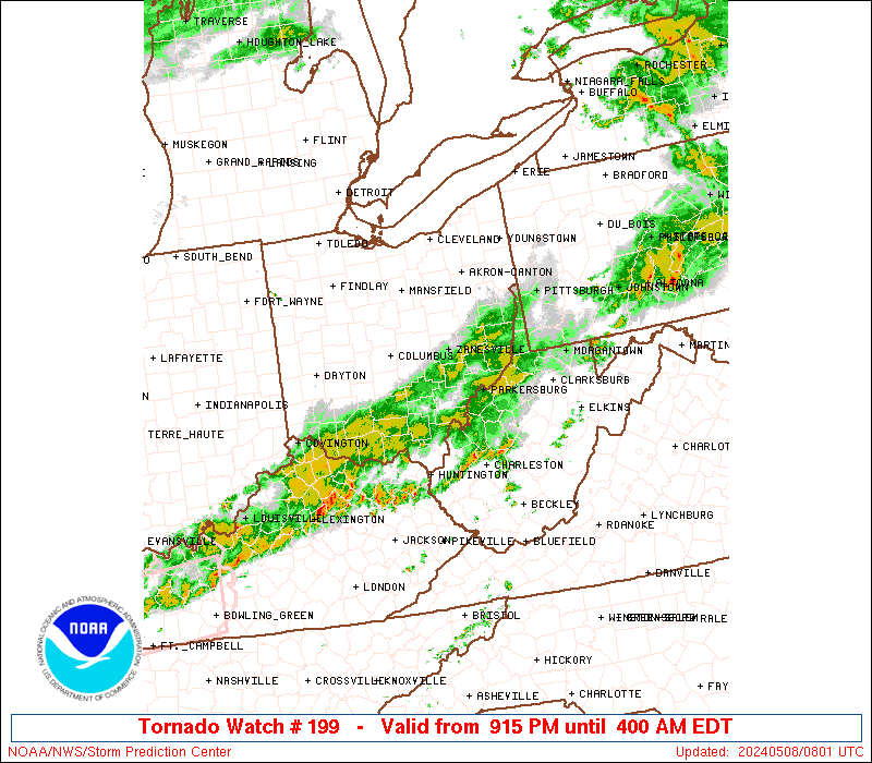
SUMMARY...Intense thunderstorms over western Ohio will track
eastward across the watch area this evening and tonight, posing a
risk of damaging winds, hail, and a few tornadoes.
The tornado watch area is approximately along and 55 statute miles
east and west of a line from 10 miles west northwest of Akron OH to
30 miles east of Huntington WV. For a complete depiction of the
watch see the associated watch outline update (WOUS64 KWNS WOU9).
PRECAUTIONARY/PREPAREDNESS ACTIONS...
REMEMBER...A Tornado Watch means conditions are favorable for
tornadoes and severe thunderstorms in and close to the watch
area. Persons in these areas should be on the lookout for
threatening weather conditions and listen for later statements
and possible warnings.
&&
OTHER WATCH INFORMATION...CONTINUE...WW 196...WW 197...WW 198...
AVIATION...Tornadoes and a few severe thunderstorms with hail
surface and aloft to 2 inches. Extreme turbulence and surface wind
gusts to 60 knots. A few cumulonimbi with maximum tops to 500. Mean
storm motion vector 25030.
...Hart

   SEL9

   URGENT - IMMEDIATE BROADCAST REQUESTED
   Tornado Watch Number 199
   NWS Storm Prediction Center Norman OK
   915 PM EDT Tue May 7 2024

   The NWS Storm Prediction Center has issued a

   * Tornado Watch for portions of
     Northeast Kentucky
     Eastern Ohio
     Northwest West Virginia

   * Effective this Tuesday night and Wednesday morning from 915 PM
     until 400 AM EDT.

   * Primary threats include...
     A few tornadoes likely
     Scattered large hail and isolated very large hail events to 2
       inches in diameter possible
     Scattered damaging wind gusts to 70 mph possible

   SUMMARY...Intense thunderstorms over western Ohio will track
   eastward across the watch area this evening and tonight, posing a
   risk of damaging winds, hail, and a few tornadoes.

   The tornado watch area is approximately along and 55 statute miles
   east and west of a line from 10 miles west northwest of Akron OH to
   30 miles east of Huntington WV. For a complete depiction of the
   watch see the associated watch outline update (WOUS64 KWNS WOU9).

   PRECAUTIONARY/PREPAREDNESS ACTIONS...

   REMEMBER...A Tornado Watch means conditions are favorable for
   tornadoes and severe thunderstorms in and close to the watch
   area. Persons in these areas should be on the lookout for
   threatening weather conditions and listen for later statements
   and possible warnings.

   &&

   OTHER WATCH INFORMATION...CONTINUE...WW 196...WW 197...WW 198...

   AVIATION...Tornadoes and a few severe thunderstorms with hail
   surface and aloft to 2 inches. Extreme turbulence and surface wind
   gusts to 60 knots. A few cumulonimbi with maximum tops to 500. Mean
   storm motion vector 25030.

   ...Hart
 Note:
The Aviation Watch (SAW) product is an approximation to the watch area.
The actual watch is depicted by the shaded areas.
Note:
The Aviation Watch (SAW) product is an approximation to the watch area.
The actual watch is depicted by the shaded areas.
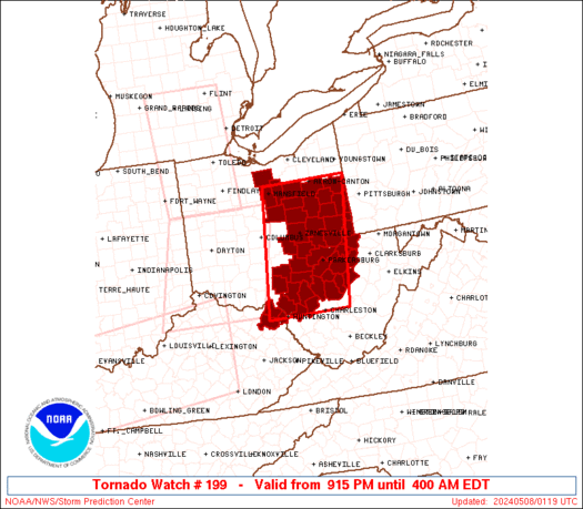
   SAW9
   WW 199 TORNADO KY OH WV 080115Z - 080800Z
   AXIS..55 STATUTE MILES EAST AND WEST OF LINE..
   10WNW CAK/AKRON OH/ - 30E HTS/HUNTINGTON WV/
   ..AVIATION COORDS.. 50NM E/W /29SSE CLE - 23S HNN/
   HAIL SURFACE AND ALOFT..2 INCHES. WIND GUSTS..60 KNOTS.
   MAX TOPS TO 500. MEAN STORM MOTION VECTOR 25030.

   LAT...LON 40978055 38348098 38348301 40978266

   THIS IS AN APPROXIMATION TO THE WATCH AREA.  FOR A
   COMPLETE DEPICTION OF THE WATCH SEE WOUS64 KWNS
   FOR WOU9.
Watch 199 Status Report Messages:
STATUS REPORT #3 ON WW 199

VALID 080425Z - 080540Z

SEVERE WEATHER THREAT CONTINUES RIGHT OF A LINE FROM 35 S CMH TO
15 ENE CAK.

..SPC..05/08/24

ATTN...WFO...RLX...CLE...PBZ...

&&

STATUS REPORT FOR WT 199

SEVERE WEATHER THREAT CONTINUES FOR THE FOLLOWING AREAS

KYC019-043-089-080540-

KY
.    KENTUCKY COUNTIES INCLUDED ARE

BOYD		     CARTER		 GREENUP
$$


OHC009-013-019-029-031-053-059-067-079-081-087-105-111-115-119-
121-127-151-157-163-167-080540-

OH
.    OHIO COUNTIES INCLUDED ARE

ATHENS		     BELMONT		 CARROLL
COLUMBIANA	     COSHOCTON		 GALLIA
GUERNSEY	     HARRISON		 JACKSON
JEFFERSON	     LAWRENCE		 MEIGS
MONROE		     MORGAN		 MUSKINGUM
NOBLE		     PERRY		 STARK
TUSCARAWAS	     VINTON		 WASHINGTON
$$


WVC009-011-013-017-021-029-035-051-053-069-073-079-085-087-095-
103-105-107-080540-

WV
.    WEST VIRGINIA COUNTIES INCLUDED ARE

BROOKE		     CABELL		 CALHOUN
DODDRIDGE	     GILMER		 HANCOCK
JACKSON 	     MARSHALL		 MASON
OHIO		     PLEASANTS		 PUTNAM
RITCHIE 	     ROANE		 TYLER
WETZEL		     WIRT		 WOOD
$$


THE WATCH STATUS MESSAGE IS FOR GUIDANCE PURPOSES ONLY.  PLEASE
REFER TO WATCH COUNTY NOTIFICATION STATEMENTS FOR OFFICIAL
INFORMATION ON COUNTIES...INDEPENDENT CITIES AND MARINE ZONES
CLEARED FROM SEVERE THUNDERSTORM AND TORNADO WATCHES.
$$

STATUS REPORT #2 ON WW 199

VALID 080325Z - 080440Z

THE SEVERE WEATHER THREAT CONTINUES ACROSS THE ENTIRE WATCH AREA.

..SPC..05/08/24

ATTN...WFO...RLX...CLE...PBZ...

&&

STATUS REPORT FOR WT 199

SEVERE WEATHER THREAT CONTINUES FOR THE FOLLOWING AREAS

KYC019-043-089-080440-

KY
.    KENTUCKY COUNTIES INCLUDED ARE

BOYD		     CARTER		 GREENUP
$$


OHC005-009-013-019-029-031-053-059-067-075-079-081-083-087-105-
111-115-119-121-127-139-151-157-163-167-169-080440-

OH
.    OHIO COUNTIES INCLUDED ARE

ASHLAND 	     ATHENS		 BELMONT
CARROLL 	     COLUMBIANA 	 COSHOCTON
GALLIA		     GUERNSEY		 HARRISON
HOLMES		     JACKSON		 JEFFERSON
KNOX		     LAWRENCE		 MEIGS
MONROE		     MORGAN		 MUSKINGUM
NOBLE		     PERRY		 RICHLAND
STARK		     TUSCARAWAS 	 VINTON
WASHINGTON	     WAYNE
$$


WVC009-011-013-017-021-029-035-051-053-069-073-079-085-087-095-
103-105-107-080440-

WV
.    WEST VIRGINIA COUNTIES INCLUDED ARE

BROOKE		     CABELL		 CALHOUN
DODDRIDGE	     GILMER		 HANCOCK
JACKSON 	     MARSHALL		 MASON
OHIO		     PLEASANTS		 PUTNAM
RITCHIE 	     ROANE		 TYLER
WETZEL		     WIRT		 WOOD
$$


THE WATCH STATUS MESSAGE IS FOR GUIDANCE PURPOSES ONLY.  PLEASE
REFER TO WATCH COUNTY NOTIFICATION STATEMENTS FOR OFFICIAL
INFORMATION ON COUNTIES...INDEPENDENT CITIES AND MARINE ZONES
CLEARED FROM SEVERE THUNDERSTORM AND TORNADO WATCHES.
$$

STATUS REPORT #1 ON WW 199

VALID 080145Z - 080240Z

THE SEVERE WEATHER THREAT CONTINUES ACROSS THE ENTIRE WATCH AREA.

..SPC..05/08/24

ATTN...WFO...RLX...CLE...PBZ...

&&

STATUS REPORT FOR WT 199

SEVERE WEATHER THREAT CONTINUES FOR THE FOLLOWING AREAS

KYC019-043-089-080240-

KY
.    KENTUCKY COUNTIES INCLUDED ARE

BOYD		     CARTER		 GREENUP
$$


OHC005-009-013-019-029-031-053-059-067-075-077-079-081-083-087-
105-111-115-119-121-127-139-151-157-163-167-169-080240-

OH
.    OHIO COUNTIES INCLUDED ARE

ASHLAND 	     ATHENS		 BELMONT
CARROLL 	     COLUMBIANA 	 COSHOCTON
GALLIA		     GUERNSEY		 HARRISON
HOLMES		     HURON		 JACKSON
JEFFERSON	     KNOX		 LAWRENCE
MEIGS		     MONROE		 MORGAN
MUSKINGUM	     NOBLE		 PERRY
RICHLAND	     STARK		 TUSCARAWAS
VINTON		     WASHINGTON 	 WAYNE
$$


WVC009-011-013-017-021-029-035-051-053-069-073-079-085-087-095-
103-105-107-080240-

WV
.    WEST VIRGINIA COUNTIES INCLUDED ARE

BROOKE		     CABELL		 CALHOUN
DODDRIDGE	     GILMER		 HANCOCK
JACKSON 	     MARSHALL		 MASON
OHIO		     PLEASANTS		 PUTNAM
RITCHIE 	     ROANE		 TYLER
WETZEL		     WIRT		 WOOD
$$


THE WATCH STATUS MESSAGE IS FOR GUIDANCE PURPOSES ONLY.  PLEASE
REFER TO WATCH COUNTY NOTIFICATION STATEMENTS FOR OFFICIAL
INFORMATION ON COUNTIES...INDEPENDENT CITIES AND MARINE ZONES
CLEARED FROM SEVERE THUNDERSTORM AND TORNADO WATCHES.
$$
Note:
Click for Complete Product Text.
Tornadoes
Probability of 2 or more tornadoes
|
Mod (60%)
|
Probability of 1 or more strong (EF2-EF5) tornadoes
|
Low (20%)
|
Wind
Probability of 10 or more severe wind events
|
Mod (40%)
|
Probability of 1 or more wind events > 65 knots
|
Low (20%)
|
Hail
Probability of 10 or more severe hail events
|
Mod (40%)
|
Probability of 1 or more hailstones > 2 inches
|
Mod (30%)
|
Combined Severe Hail/Wind
Probability of 6 or more combined severe hail/wind events
|
High (70%)
|
For each watch, probabilities for particular events inside the watch
(listed above in each table) are determined by the issuing forecaster.
The "Low" category contains probability values ranging from less than 2%
to 20% (EF2-EF5 tornadoes), less than 5% to 20% (all other probabilities),
"Moderate" from 30% to 60%, and "High" from 70% to greater than 95%.
High values are bolded and lighter in color to provide awareness of
an increased threat for a particular event.


 @NWSSPC