Note:
The expiration time in the watch graphic is amended if the watch is
replaced, cancelled or extended.
Note:
Note:
The expiration time in the watch graphic is amended if the watch is
replaced, cancelled or extended.
Note: Click for
Watch Status Reports.
SEL2
URGENT - IMMEDIATE BROADCAST REQUESTED
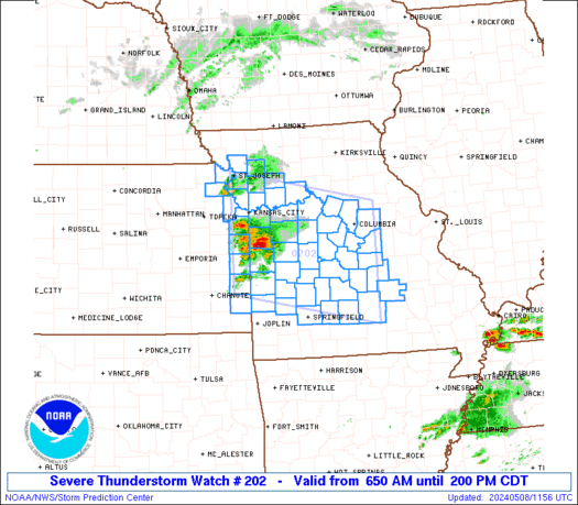
Severe Thunderstorm Watch Number 202
NWS Storm Prediction Center Norman OK
650 AM CDT Wed May 8 2024
The NWS Storm Prediction Center has issued a
* Severe Thunderstorm Watch for portions of
Extreme eastern Kansas
Western and central Missouri
* Effective this Wednesday morning and afternoon from 650 AM
until 200 PM CDT.
* Primary threats include...
Scattered large hail and isolated very large hail events to 3
inches in diameter likely
Scattered damaging wind gusts to 70 mph possible
SUMMARY...Initially elevated thunderstorms erupting near the KS/MO
line will pose a threat for large to very large hail through midday
as individual cells move northeastward to eastward. A portion of
this activity may organize into an eastward- to
southeastward-moving, upscale-growing cluster with increasing
damaging-wind potential.
The severe thunderstorm watch area is approximately along and 75
statute miles north and south of a line from 15 miles west southwest
of Olathe KS to Vichy MO. For a complete depiction of the watch see
the associated watch outline update (WOUS64 KWNS WOU2).
PRECAUTIONARY/PREPAREDNESS ACTIONS...
REMEMBER...A Severe Thunderstorm Watch means conditions are
favorable for severe thunderstorms in and close to the watch area.
Persons in these areas should be on the lookout for threatening
weather conditions and listen for later statements and possible
warnings. Severe thunderstorms can and occasionally do produce
tornadoes.
&&
AVIATION...A few severe thunderstorms with hail surface and aloft to
3 inches. Extreme turbulence and surface wind gusts to 60 knots. A
few cumulonimbi with maximum tops to 550. Mean storm motion vector
27030.
...Edwards
   SEL2

   URGENT - IMMEDIATE BROADCAST REQUESTED
   Severe Thunderstorm Watch Number 202
   NWS Storm Prediction Center Norman OK
   650 AM CDT Wed May 8 2024

   The NWS Storm Prediction Center has issued a

   * Severe Thunderstorm Watch for portions of
     Extreme eastern Kansas
     Western and central Missouri

   * Effective this Wednesday morning and afternoon from 650 AM
     until 200 PM CDT.

   * Primary threats include...
     Scattered large hail and isolated very large hail events to 3
       inches in diameter likely
     Scattered damaging wind gusts to 70 mph possible

   SUMMARY...Initially elevated thunderstorms erupting near the KS/MO
   line will pose a threat for large to very large hail through midday
   as individual cells move northeastward to eastward.  A portion of
   this activity may organize into an eastward- to
   southeastward-moving, upscale-growing cluster with increasing
   damaging-wind potential.

   The severe thunderstorm watch area is approximately along and 75
   statute miles north and south of a line from 15 miles west southwest
   of Olathe KS to Vichy MO. For a complete depiction of the watch see
   the associated watch outline update (WOUS64 KWNS WOU2).

   PRECAUTIONARY/PREPAREDNESS ACTIONS...

   REMEMBER...A Severe Thunderstorm Watch means conditions are
   favorable for severe thunderstorms in and close to the watch area.
   Persons in these areas should be on the lookout for threatening
   weather conditions and listen for later statements and possible
   warnings. Severe thunderstorms can and occasionally do produce
   tornadoes.

   &&

   AVIATION...A few severe thunderstorms with hail surface and aloft to
   3 inches. Extreme turbulence and surface wind gusts to 60 knots. A
   few cumulonimbi with maximum tops to 550. Mean storm motion vector
   27030.

   ...Edwards
 Note:
The Aviation Watch (SAW) product is an approximation to the watch area.
The actual watch is depicted by the shaded areas.
Note:
The Aviation Watch (SAW) product is an approximation to the watch area.
The actual watch is depicted by the shaded areas.
   SAW2
   WW 202 SEVERE TSTM KS MO 081150Z - 081900Z
   AXIS..75 STATUTE MILES NORTH AND SOUTH OF LINE..
   15WSW OJC/OLATHE KS/ - VIH/VICHY MO/
   ..AVIATION COORDS.. 65NM N/S /33SSW MCI - 47SSE COU/
   HAIL SURFACE AND ALOFT..3 INCHES. WIND GUSTS..60 KNOTS.
   MAX TOPS TO 550. MEAN STORM MOTION VECTOR 27030.

   LAT...LON 39849499 39229177 37049177 37689499

   THIS IS AN APPROXIMATION TO THE WATCH AREA.  FOR A
   COMPLETE DEPICTION OF THE WATCH SEE WOUS64 KWNS
   FOR WOU2.
Watch 202 Status Report Messages:
STATUS REPORT #6 ON WW 202

VALID 081845Z - 081940Z

SEVERE WEATHER THREAT CONTINUES RIGHT OF A LINE FROM 35 NW JLN TO
60 SSE OJC TO 25 SSW SZL TO 25 WNW COU TO 45 NNE COU.

..BENTLEY..05/08/24

ATTN...WFO...EAX...SGF...LSX...

&&

STATUS REPORT FOR WS 202

SEVERE WEATHER THREAT CONTINUES FOR THE FOLLOWING AREAS

MOC013-015-019-027-051-053-083-125-131-135-141-151-159-081940-

MO
.    MISSOURI COUNTIES INCLUDED ARE

BATES		     BENTON		 BOONE
CALLAWAY	     COLE		 COOPER
HENRY		     MARIES		 MILLER
MONITEAU	     MORGAN		 OSAGE
PETTIS
$$


THE WATCH STATUS MESSAGE IS FOR GUIDANCE PURPOSES ONLY.  PLEASE
REFER TO WATCH COUNTY NOTIFICATION STATEMENTS FOR OFFICIAL
INFORMATION ON COUNTIES...INDEPENDENT CITIES AND MARINE ZONES
CLEARED FROM SEVERE THUNDERSTORM AND TORNADO WATCHES.
$$

STATUS REPORT #5 ON WW 202

VALID 081740Z - 081840Z

SEVERE WEATHER THREAT CONTINUES RIGHT OF A LINE FROM 25 NE CNU TO
40 SSE OJC TO 25 WNW SZL TO 25 ESE CDJ.

..BENTLEY..05/08/24

ATTN...WFO...EAX...SGF...LSX...

&&

STATUS REPORT FOR WS 202

SEVERE WEATHER THREAT CONTINUES FOR THE FOLLOWING AREAS

MOC013-015-019-027-033-051-053-083-089-101-107-125-131-135-141-
151-159-195-081840-

MO
.    MISSOURI COUNTIES INCLUDED ARE

BATES		     BENTON		 BOONE
CALLAWAY	     CARROLL		 COLE
COOPER		     HENRY		 HOWARD
JOHNSON 	     LAFAYETTE		 MARIES
MILLER		     MONITEAU		 MORGAN
OSAGE		     PETTIS		 SALINE
$$


THE WATCH STATUS MESSAGE IS FOR GUIDANCE PURPOSES ONLY.  PLEASE
REFER TO WATCH COUNTY NOTIFICATION STATEMENTS FOR OFFICIAL
INFORMATION ON COUNTIES...INDEPENDENT CITIES AND MARINE ZONES
CLEARED FROM SEVERE THUNDERSTORM AND TORNADO WATCHES.
$$

STATUS REPORT #4 ON WW 202

VALID 081705Z - 081840Z

SEVERE WEATHER THREAT CONTINUES RIGHT OF A LINE FROM 30 NE CNU TO
30 ESE OJC TO 20 SE CDJ.

..BENTLEY..05/08/24

ATTN...WFO...EAX...SGF...LSX...

&&

STATUS REPORT FOR WS 202

SEVERE WEATHER THREAT CONTINUES FOR THE FOLLOWING AREAS

MOC013-015-019-027-033-051-053-083-089-101-107-125-131-135-141-
151-159-195-081840-

MO
.    MISSOURI COUNTIES INCLUDED ARE

BATES		     BENTON		 BOONE
CALLAWAY	     CARROLL		 COLE
COOPER		     HENRY		 HOWARD
JOHNSON 	     LAFAYETTE		 MARIES
MILLER		     MONITEAU		 MORGAN
OSAGE		     PETTIS		 SALINE
$$


THE WATCH STATUS MESSAGE IS FOR GUIDANCE PURPOSES ONLY.  PLEASE
REFER TO WATCH COUNTY NOTIFICATION STATEMENTS FOR OFFICIAL
INFORMATION ON COUNTIES...INDEPENDENT CITIES AND MARINE ZONES
CLEARED FROM SEVERE THUNDERSTORM AND TORNADO WATCHES.
$$

STATUS REPORT #3 ON WW 202

VALID 081525Z - 081640Z

SEVERE WEATHER THREAT CONTINUES RIGHT OF A LINE FROM 35 NE CNU TO
20 SSE CDJ.

..GRAMS..05/08/24

ATTN...WFO...EAX...SGF...LSX...

&&

STATUS REPORT FOR WS 202

SEVERE WEATHER THREAT CONTINUES FOR THE FOLLOWING AREAS

KSC011-037-081640-

KS
.    KANSAS COUNTIES INCLUDED ARE

BOURBON 	     CRAWFORD
$$


MOC011-013-015-019-027-029-033-039-051-053-057-059-065-077-083-
085-089-101-105-107-125-131-135-141-151-159-161-167-169-185-195-
215-217-225-229-081640-

MO
.    MISSOURI COUNTIES INCLUDED ARE

BARTON		     BATES		 BENTON
BOONE		     CALLAWAY		 CAMDEN
CARROLL 	     CEDAR		 COLE
COOPER		     DADE		 DALLAS
DENT		     GREENE		 HENRY
HICKORY 	     HOWARD		 JOHNSON
LACLEDE 	     LAFAYETTE		 MARIES
MILLER		     MONITEAU		 MORGAN
OSAGE		     PETTIS		 PHELPS
POLK		     PULASKI		 ST. CLAIR
SALINE		     TEXAS		 VERNON
WEBSTER 	     WRIGHT
$$


THE WATCH STATUS MESSAGE IS FOR GUIDANCE PURPOSES ONLY.  PLEASE
REFER TO WATCH COUNTY NOTIFICATION STATEMENTS FOR OFFICIAL
INFORMATION ON COUNTIES...INDEPENDENT CITIES AND MARINE ZONES
CLEARED FROM SEVERE THUNDERSTORM AND TORNADO WATCHES.
$$

STATUS REPORT #2 ON WW 202

VALID 081425Z - 081540Z

SEVERE WEATHER THREAT CONTINUES RIGHT OF A LINE FROM 40 SSW OJC
TO 20 S CDJ.

FOR ADDITIONAL INFORMATION SEE MESOSCALE DISCUSSION 694.

..GRAMS..05/08/24

ATTN...WFO...EAX...SGF...LSX...

&&

STATUS REPORT FOR WS 202

SEVERE WEATHER THREAT CONTINUES FOR THE FOLLOWING AREAS

KSC011-037-107-081540-

KS
.    KANSAS COUNTIES INCLUDED ARE

BOURBON 	     CRAWFORD		 LINN
$$


MOC011-013-015-019-027-029-033-037-039-051-053-057-059-065-077-
083-085-089-101-105-107-125-131-135-141-151-159-161-167-169-185-
195-215-217-225-229-081540-

MO
.    MISSOURI COUNTIES INCLUDED ARE

BARTON		     BATES		 BENTON
BOONE		     CALLAWAY		 CAMDEN
CARROLL 	     CASS		 CEDAR
COLE		     COOPER		 DADE
DALLAS		     DENT		 GREENE
HENRY		     HICKORY		 HOWARD
JOHNSON 	     LACLEDE		 LAFAYETTE
MARIES		     MILLER		 MONITEAU
MORGAN		     OSAGE		 PETTIS
PHELPS		     POLK		 PULASKI
ST. CLAIR	     SALINE		 TEXAS
VERNON		     WEBSTER		 WRIGHT
$$


THE WATCH STATUS MESSAGE IS FOR GUIDANCE PURPOSES ONLY.  PLEASE
REFER TO WATCH COUNTY NOTIFICATION STATEMENTS FOR OFFICIAL
INFORMATION ON COUNTIES...INDEPENDENT CITIES AND MARINE ZONES
CLEARED FROM SEVERE THUNDERSTORM AND TORNADO WATCHES.
$$

STATUS REPORT #1 ON WW 202

VALID 081335Z - 081440Z

SEVERE WEATHER THREAT CONTINUES RIGHT OF A LINE FROM 15 WSW OJC
TO 30 WSW CDJ.

..GRAMS..05/08/24

ATTN...WFO...EAX...SGF...LSX...

&&

STATUS REPORT FOR WS 202

SEVERE WEATHER THREAT CONTINUES FOR THE FOLLOWING AREAS

KSC011-037-091-107-121-209-081440-

KS
.    KANSAS COUNTIES INCLUDED ARE

BOURBON 	     CRAWFORD		 JOHNSON
LINN		     MIAMI		 WYANDOTTE
$$


MOC011-013-015-019-025-027-029-033-037-039-047-051-053-057-059-
065-077-083-085-089-095-101-105-107-125-131-135-141-151-159-161-
167-169-177-185-195-215-217-225-229-081440-

MO
.    MISSOURI COUNTIES INCLUDED ARE

BARTON		     BATES		 BENTON
BOONE		     CALDWELL		 CALLAWAY
CAMDEN		     CARROLL		 CASS
CEDAR		     CLAY		 COLE
COOPER		     DADE		 DALLAS
DENT		     GREENE		 HENRY
HICKORY 	     HOWARD		 JACKSON
JOHNSON 	     LACLEDE		 LAFAYETTE
MARIES		     MILLER		 MONITEAU
MORGAN		     OSAGE		 PETTIS
PHELPS		     POLK		 PULASKI
RAY		     ST. CLAIR		 SALINE
TEXAS		     VERNON		 WEBSTER
WRIGHT
$$


THE WATCH STATUS MESSAGE IS FOR GUIDANCE PURPOSES ONLY.  PLEASE
REFER TO WATCH COUNTY NOTIFICATION STATEMENTS FOR OFFICIAL
INFORMATION ON COUNTIES...INDEPENDENT CITIES AND MARINE ZONES
CLEARED FROM SEVERE THUNDERSTORM AND TORNADO WATCHES.
$$
Note:
Click for Complete Product Text.
Tornadoes
Probability of 2 or more tornadoes
|
Low (10%)
|
Probability of 1 or more strong (EF2-EF5) tornadoes
|
Low (5%)
|
Wind
Probability of 10 or more severe wind events
|
Mod (50%)
|
Probability of 1 or more wind events > 65 knots
|
Low (10%)
|
Hail
Probability of 10 or more severe hail events
|
High (70%)
|
Probability of 1 or more hailstones > 2 inches
|
Mod (60%)
|
Combined Severe Hail/Wind
Probability of 6 or more combined severe hail/wind events
|
High (>95%)
|
For each watch, probabilities for particular events inside the watch
(listed above in each table) are determined by the issuing forecaster.
The "Low" category contains probability values ranging from less than 2%
to 20% (EF2-EF5 tornadoes), less than 5% to 20% (all other probabilities),
"Moderate" from 30% to 60%, and "High" from 70% to greater than 95%.
High values are bolded and lighter in color to provide awareness of
an increased threat for a particular event.


 @NWSSPC