 Note:
The expiration time in the watch graphic is amended if the watch is
replaced, cancelled or extended.
Note:
Note:
The expiration time in the watch graphic is amended if the watch is
replaced, cancelled or extended.
Note: Click for
Watch Status Reports.
SEL3
URGENT - IMMEDIATE BROADCAST REQUESTED
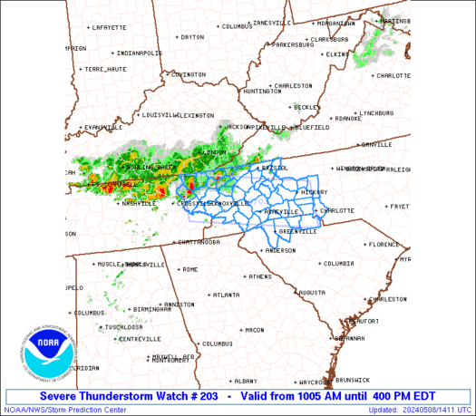
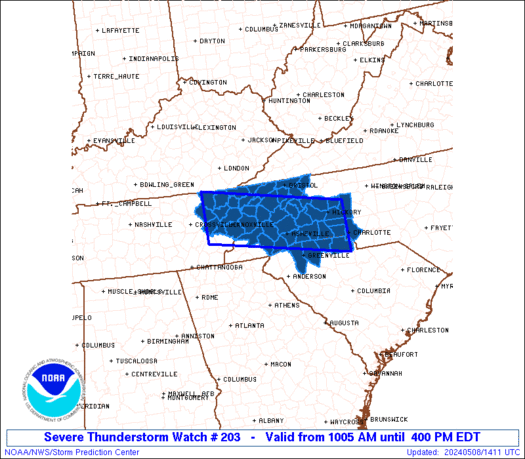
Severe Thunderstorm Watch Number 203
NWS Storm Prediction Center Norman OK
1005 AM EDT Wed May 8 2024
The NWS Storm Prediction Center has issued a
* Severe Thunderstorm Watch for portions of
Western North Carolina
Upstate South Carolina
Eastern Tennessee
* Effective this Wednesday morning and afternoon from 1005 AM
until 400 PM EDT.
* Primary threats include...
Scattered damaging wind gusts to 70 mph likely
Scattered large hail events to 1.5 inches in diameter likely
SUMMARY...Clusters of storms, with both bowing and embedded
supercell characteristics, will likely continue into the afternoon
while spreading east-southeastward across eastern Tennessee into
western North Carolina and the northern part of upstate South
Carolina. Scattered damaging winds of 60-70 mph and large hail of
1-1.5 inches in diameter can be expected.
The severe thunderstorm watch area is approximately along and 40
statute miles north and south of a line from 40 miles west northwest
of Knoxville TN to 10 miles north of Charlotte NC. For a complete
depiction of the watch see the associated watch outline update
(WOUS64 KWNS WOU3).
PRECAUTIONARY/PREPAREDNESS ACTIONS...
REMEMBER...A Severe Thunderstorm Watch means conditions are
favorable for severe thunderstorms in and close to the watch area.
Persons in these areas should be on the lookout for threatening
weather conditions and listen for later statements and possible
warnings. Severe thunderstorms can and occasionally do produce
tornadoes.
&&
OTHER WATCH INFORMATION...CONTINUE...WW 202...
AVIATION...A few severe thunderstorms with hail surface and aloft to
1.5 inches. Extreme turbulence and surface wind gusts to 60 knots. A
few cumulonimbi with maximum tops to 500. Mean storm motion vector
24035.
...Thompson

   SEL3

   URGENT - IMMEDIATE BROADCAST REQUESTED
   Severe Thunderstorm Watch Number 203
   NWS Storm Prediction Center Norman OK
   1005 AM EDT Wed May 8 2024

   The NWS Storm Prediction Center has issued a

   * Severe Thunderstorm Watch for portions of
     Western North Carolina
     Upstate South Carolina
     Eastern Tennessee

   * Effective this Wednesday morning and afternoon from 1005 AM
     until 400 PM EDT.

   * Primary threats include...
     Scattered damaging wind gusts to 70 mph likely
     Scattered large hail events to 1.5 inches in diameter likely

   SUMMARY...Clusters of storms, with both bowing and embedded
   supercell characteristics, will likely continue into the afternoon
   while spreading east-southeastward across eastern Tennessee into
   western North Carolina and the northern part of upstate South
   Carolina.  Scattered damaging winds of 60-70 mph and large hail of
   1-1.5 inches in diameter can be expected.

   The severe thunderstorm watch area is approximately along and 40
   statute miles north and south of a line from 40 miles west northwest
   of Knoxville TN to 10 miles north of Charlotte NC. For a complete
   depiction of the watch see the associated watch outline update
   (WOUS64 KWNS WOU3).

   PRECAUTIONARY/PREPAREDNESS ACTIONS...

   REMEMBER...A Severe Thunderstorm Watch means conditions are
   favorable for severe thunderstorms in and close to the watch area.
   Persons in these areas should be on the lookout for threatening
   weather conditions and listen for later statements and possible
   warnings. Severe thunderstorms can and occasionally do produce
   tornadoes.

   &&

   OTHER WATCH INFORMATION...CONTINUE...WW 202...

   AVIATION...A few severe thunderstorms with hail surface and aloft to
   1.5 inches. Extreme turbulence and surface wind gusts to 60 knots. A
   few cumulonimbi with maximum tops to 500. Mean storm motion vector
   24035.

   ...Thompson
 Note:
The Aviation Watch (SAW) product is an approximation to the watch area.
The actual watch is depicted by the shaded areas.
Note:
The Aviation Watch (SAW) product is an approximation to the watch area.
The actual watch is depicted by the shaded areas.
   SAW3
   WW 203 SEVERE TSTM NC SC TN 081405Z - 082000Z
   AXIS..40 STATUTE MILES NORTH AND SOUTH OF LINE..
   40WNW TYS/KNOXVILLE TN/ - 10N CLT/CHARLOTTE NC/
   ..AVIATION COORDS.. 35NM N/S /38WNW VXV - 9N CLT/
   HAIL SURFACE AND ALOFT..1.5 INCHES. WIND GUSTS..60 KNOTS.
   MAX TOPS TO 500. MEAN STORM MOTION VECTOR 24035.

   LAT...LON 36628466 35938094 34798094 35468466

   THIS IS AN APPROXIMATION TO THE WATCH AREA.  FOR A
   COMPLETE DEPICTION OF THE WATCH SEE WOUS64 KWNS
   FOR WOU3.
Watch 203 Status Report Messages:
STATUS REPORT #5 ON WW 203

VALID 081930Z - 082040Z

SEVERE WEATHER THREAT CONTINUES RIGHT OF A LINE FROM 40 S TYS TO
15 WNW AVL TO 35 W HKY TO 35 NE HKY.

..BENTLEY..05/08/24

ATTN...WFO...GSP...MRX...

&&

STATUS REPORT FOR WS 203

SEVERE WEATHER THREAT CONTINUES FOR THE FOLLOWING AREAS

NCC003-011-021-023-027-035-045-071-087-089-097-099-109-111-119-
149-161-173-175-082040-

NC
.    NORTH CAROLINA COUNTIES INCLUDED ARE

ALEXANDER	     AVERY		 BUNCOMBE
BURKE		     CALDWELL		 CATAWBA
CLEVELAND	     GASTON		 HAYWOOD
HENDERSON	     IREDELL		 JACKSON
LINCOLN 	     MCDOWELL		 MECKLENBURG
POLK		     RUTHERFORD 	 SWAIN
TRANSYLVANIA
$$


SCC021-045-083-091-082040-

SC
.    SOUTH CAROLINA COUNTIES INCLUDED ARE

CHEROKEE	     GREENVILLE 	 SPARTANBURG
YORK
$$


THE WATCH STATUS MESSAGE IS FOR GUIDANCE PURPOSES ONLY.  PLEASE
REFER TO WATCH COUNTY NOTIFICATION STATEMENTS FOR OFFICIAL
INFORMATION ON COUNTIES...INDEPENDENT CITIES AND MARINE ZONES
CLEARED FROM SEVERE THUNDERSTORM AND TORNADO WATCHES.
$$

STATUS REPORT #4 ON WW 203

VALID 081840Z - 081940Z

SEVERE WEATHER THREAT CONTINUES RIGHT OF A LINE FROM 25 SE CSV TO
25 SSE TYS TO 15 SE HSS TO 30 NW HKY TO 40 NNE HKY.

..BENTLEY..05/08/24

ATTN...WFO...GSP...MRX...

&&

STATUS REPORT FOR WS 203

SEVERE WEATHER THREAT CONTINUES FOR THE FOLLOWING AREAS

NCC003-021-023-027-035-045-071-087-089-097-099-109-111-119-149-
161-173-175-199-081940-

NC
.    NORTH CAROLINA COUNTIES INCLUDED ARE

ALEXANDER	     BUNCOMBE		 BURKE
CALDWELL	     CATAWBA		 CLEVELAND
GASTON		     HAYWOOD		 HENDERSON
IREDELL 	     JACKSON		 LINCOLN
MCDOWELL	     MECKLENBURG	 POLK
RUTHERFORD	     SWAIN		 TRANSYLVANIA
YANCEY
$$


SCC021-045-083-091-081940-

SC
.    SOUTH CAROLINA COUNTIES INCLUDED ARE

CHEROKEE	     GREENVILLE 	 SPARTANBURG
YORK
$$


TNC009-105-145-081940-

TN
.    TENNESSEE COUNTIES INCLUDED ARE

BLOUNT		     LOUDON		 ROANE
$$


THE WATCH STATUS MESSAGE IS FOR GUIDANCE PURPOSES ONLY.  PLEASE
REFER TO WATCH COUNTY NOTIFICATION STATEMENTS FOR OFFICIAL
INFORMATION ON COUNTIES...INDEPENDENT CITIES AND MARINE ZONES
CLEARED FROM SEVERE THUNDERSTORM AND TORNADO WATCHES.
$$

STATUS REPORT #3 ON WW 203

VALID 081740Z - 081840Z

SEVERE WEATHER THREAT CONTINUES RIGHT OF A LINE FROM 20 ESE CSV
TO 5 ENE TYS TO 30 W HSS TO 30 SE TRI TO 40 NNW HKY.

..BENTLEY..05/08/24

ATTN...WFO...GSP...MRX...

&&

STATUS REPORT FOR WS 203

SEVERE WEATHER THREAT CONTINUES FOR THE FOLLOWING AREAS

NCC003-011-021-023-027-035-045-071-087-089-097-099-109-111-115-
119-121-149-161-173-175-199-081840-

NC
.    NORTH CAROLINA COUNTIES INCLUDED ARE

ALEXANDER	     AVERY		 BUNCOMBE
BURKE		     CALDWELL		 CATAWBA
CLEVELAND	     GASTON		 HAYWOOD
HENDERSON	     IREDELL		 JACKSON
LINCOLN 	     MCDOWELL		 MADISON
MECKLENBURG	     MITCHELL		 POLK
RUTHERFORD	     SWAIN		 TRANSYLVANIA
YANCEY
$$


SCC021-045-083-091-081840-

SC
.    SOUTH CAROLINA COUNTIES INCLUDED ARE

CHEROKEE	     GREENVILLE 	 SPARTANBURG
YORK
$$


TNC009-019-029-093-105-145-155-081840-

TN
.    TENNESSEE COUNTIES INCLUDED ARE

BLOUNT		     CARTER		 COCKE
KNOX		     LOUDON		 ROANE
SEVIER
$$


THE WATCH STATUS MESSAGE IS FOR GUIDANCE PURPOSES ONLY.  PLEASE
REFER TO WATCH COUNTY NOTIFICATION STATEMENTS FOR OFFICIAL
INFORMATION ON COUNTIES...INDEPENDENT CITIES AND MARINE ZONES
CLEARED FROM SEVERE THUNDERSTORM AND TORNADO WATCHES.
$$

STATUS REPORT #2 ON WW 203

VALID 081700Z - 081840Z

SEVERE WEATHER THREAT CONTINUES RIGHT OF A LINE FROM 15 E CSV TO
35 ENE TYS TO 30 SE TRI.

..BENTLEY..05/08/24

ATTN...WFO...GSP...MRX...

&&

STATUS REPORT FOR WS 203

SEVERE WEATHER THREAT CONTINUES FOR THE FOLLOWING AREAS

NCC003-011-021-023-027-035-045-071-087-089-097-099-109-111-115-
119-121-149-161-173-175-199-081840-

NC
.    NORTH CAROLINA COUNTIES INCLUDED ARE

ALEXANDER	     AVERY		 BUNCOMBE
BURKE		     CALDWELL		 CATAWBA
CLEVELAND	     GASTON		 HAYWOOD
HENDERSON	     IREDELL		 JACKSON
LINCOLN 	     MCDOWELL		 MADISON
MECKLENBURG	     MITCHELL		 POLK
RUTHERFORD	     SWAIN		 TRANSYLVANIA
YANCEY
$$


SCC021-045-083-091-081840-

SC
.    SOUTH CAROLINA COUNTIES INCLUDED ARE

CHEROKEE	     GREENVILLE 	 SPARTANBURG
YORK
$$


TNC001-009-019-029-059-089-091-093-105-129-145-155-171-179-
081840-

TN
.    TENNESSEE COUNTIES INCLUDED ARE

ANDERSON	     BLOUNT		 CARTER
COCKE		     GREENE		 JEFFERSON
JOHNSON 	     KNOX		 LOUDON
MORGAN		     ROANE		 SEVIER
UNICOI		     WASHINGTON
$$


THE WATCH STATUS MESSAGE IS FOR GUIDANCE PURPOSES ONLY.  PLEASE
REFER TO WATCH COUNTY NOTIFICATION STATEMENTS FOR OFFICIAL
INFORMATION ON COUNTIES...INDEPENDENT CITIES AND MARINE ZONES
CLEARED FROM SEVERE THUNDERSTORM AND TORNADO WATCHES.
$$

STATUS REPORT #1 ON WW 203

VALID 081535Z - 081640Z

SEVERE WEATHER THREAT CONTINUES RIGHT OF A LINE FROM 30 NE CSV TO
35 NNW HSS.

FOR ADDITIONAL INFORMATION SEE MESOSCALE DISCUSSION 695.

..GRAMS..05/08/24

ATTN...WFO...GSP...MRX...

&&

STATUS REPORT FOR WS 203

SEVERE WEATHER THREAT CONTINUES FOR THE FOLLOWING AREAS

NCC003-011-021-023-027-035-045-071-087-089-097-099-109-111-115-
119-121-149-161-173-175-199-081640-

NC
.    NORTH CAROLINA COUNTIES INCLUDED ARE

ALEXANDER	     AVERY		 BUNCOMBE
BURKE		     CALDWELL		 CATAWBA
CLEVELAND	     GASTON		 HAYWOOD
HENDERSON	     IREDELL		 JACKSON
LINCOLN 	     MCDOWELL		 MADISON
MECKLENBURG	     MITCHELL		 POLK
RUTHERFORD	     SWAIN		 TRANSYLVANIA
YANCEY
$$


SCC021-045-083-091-081640-

SC
.    SOUTH CAROLINA COUNTIES INCLUDED ARE

CHEROKEE	     GREENVILLE 	 SPARTANBURG
YORK
$$


TNC001-009-019-029-057-059-063-073-089-091-093-105-129-145-155-
163-171-173-179-081640-

TN
.    TENNESSEE COUNTIES INCLUDED ARE

ANDERSON	     BLOUNT		 CARTER
COCKE		     GRAINGER		 GREENE
HAMBLEN 	     HAWKINS		 JEFFERSON
JOHNSON 	     KNOX		 LOUDON
MORGAN		     ROANE		 SEVIER
SULLIVAN	     UNICOI		 UNION
WASHINGTON
$$


THE WATCH STATUS MESSAGE IS FOR GUIDANCE PURPOSES ONLY.  PLEASE
REFER TO WATCH COUNTY NOTIFICATION STATEMENTS FOR OFFICIAL
INFORMATION ON COUNTIES...INDEPENDENT CITIES AND MARINE ZONES
CLEARED FROM SEVERE THUNDERSTORM AND TORNADO WATCHES.
$$
Note:
Click for Complete Product Text.
Tornadoes
Probability of 2 or more tornadoes
|
Low (10%)
|
Probability of 1 or more strong (EF2-EF5) tornadoes
|
Low (<2%)
|
Wind
Probability of 10 or more severe wind events
|
Mod (60%)
|
Probability of 1 or more wind events > 65 knots
|
Low (20%)
|
Hail
Probability of 10 or more severe hail events
|
Mod (60%)
|
Probability of 1 or more hailstones > 2 inches
|
Low (20%)
|
Combined Severe Hail/Wind
Probability of 6 or more combined severe hail/wind events
|
High (90%)
|
For each watch, probabilities for particular events inside the watch
(listed above in each table) are determined by the issuing forecaster.
The "Low" category contains probability values ranging from less than 2%
to 20% (EF2-EF5 tornadoes), less than 5% to 20% (all other probabilities),
"Moderate" from 30% to 60%, and "High" from 70% to greater than 95%.
High values are bolded and lighter in color to provide awareness of
an increased threat for a particular event.


 @NWSSPC


