 Note:
The expiration time in the watch graphic is amended if the watch is
replaced, cancelled or extended.
Note:
Note:
The expiration time in the watch graphic is amended if the watch is
replaced, cancelled or extended.
Note: Click for
Watch Status Reports.
SEL4
URGENT - IMMEDIATE BROADCAST REQUESTED
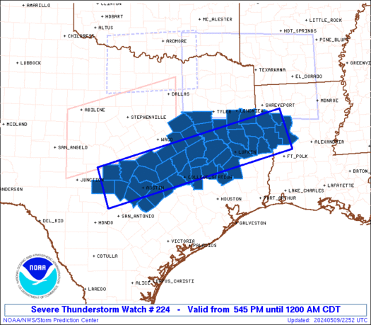
Severe Thunderstorm Watch Number 224
NWS Storm Prediction Center Norman OK
545 PM CDT Thu May 9 2024
The NWS Storm Prediction Center has issued a
* Severe Thunderstorm Watch for portions of
West Central Louisiana
Central and East Texas
* Effective this Thursday afternoon from 545 PM until Midnight
CDT.
* Primary threats include...
Scattered damaging winds and isolated significant gusts to 80
mph likely
Scattered large hail and isolated very large hail events to 3
inches in diameter likely
A tornado or two possible
SUMMARY...Isolated supercell thunderstorms over central Texas will
track eastward and become more numerous through the evening,
spreading across the watch area. Very large hail and perhaps a
tornado are the main threats early, with an increasing risk of
damaging winds by late evening.
The severe thunderstorm watch area is approximately along and 40
statute miles either side of a line from 75 miles west of Austin TX
to 105 miles east northeast of Lufkin TX. For a complete depiction
of the watch see the associated watch outline update (WOUS64 KWNS
WOU4).
PRECAUTIONARY/PREPAREDNESS ACTIONS...
REMEMBER...A Severe Thunderstorm Watch means conditions are
favorable for severe thunderstorms in and close to the watch area.
Persons in these areas should be on the lookout for threatening
weather conditions and listen for later statements and possible
warnings. Severe thunderstorms can and occasionally do produce
tornadoes.
&&
OTHER WATCH INFORMATION...CONTINUE...WW 219...WW 220...WW
221...WW 222...WW 223...
AVIATION...A few severe thunderstorms with hail surface and aloft to
3 inches. Extreme turbulence and surface wind gusts to 70 knots. A
few cumulonimbi with maximum tops to 500. Mean storm motion vector
29030.
...Hart

   SEL4

   URGENT - IMMEDIATE BROADCAST REQUESTED
   Severe Thunderstorm Watch Number 224
   NWS Storm Prediction Center Norman OK
   545 PM CDT Thu May 9 2024

   The NWS Storm Prediction Center has issued a

   * Severe Thunderstorm Watch for portions of
     West Central Louisiana
     Central and East Texas

   * Effective this Thursday afternoon from 545 PM until Midnight
     CDT.

   * Primary threats include...
     Scattered damaging winds and isolated significant gusts to 80
       mph likely
     Scattered large hail and isolated very large hail events to 3
       inches in diameter likely
     A tornado or two possible

   SUMMARY...Isolated supercell thunderstorms over central Texas will
   track eastward and become more numerous through the evening,
   spreading across the watch area.  Very large hail and perhaps a
   tornado are the main threats early, with an increasing risk of
   damaging winds by late evening.

   The severe thunderstorm watch area is approximately along and 40
   statute miles either side of a line from 75 miles west of Austin TX
   to 105 miles east northeast of Lufkin TX. For a complete depiction
   of the watch see the associated watch outline update (WOUS64 KWNS
   WOU4).

   PRECAUTIONARY/PREPAREDNESS ACTIONS...

   REMEMBER...A Severe Thunderstorm Watch means conditions are
   favorable for severe thunderstorms in and close to the watch area.
   Persons in these areas should be on the lookout for threatening
   weather conditions and listen for later statements and possible
   warnings. Severe thunderstorms can and occasionally do produce
   tornadoes.

   &&

   OTHER WATCH INFORMATION...CONTINUE...WW 219...WW 220...WW
   221...WW 222...WW 223...

   AVIATION...A few severe thunderstorms with hail surface and aloft to
   3 inches. Extreme turbulence and surface wind gusts to 70 knots. A
   few cumulonimbi with maximum tops to 500. Mean storm motion vector
   29030.

   ...Hart
 Note:
The Aviation Watch (SAW) product is an approximation to the watch area.
The actual watch is depicted by the shaded areas.
Note:
The Aviation Watch (SAW) product is an approximation to the watch area.
The actual watch is depicted by the shaded areas.
   SAW4
   WW 224 SEVERE TSTM LA TX 092245Z - 100500Z
   AXIS..40 STATUTE MILES EITHER SIDE OF LINE..
   75W AUS/AUSTIN TX/ - 105ENE LFK/LUFKIN TX/
   ..AVIATION COORDS.. 35NM EITHER SIDE /47NNW SAT - 45NW AEX/
   HAIL SURFACE AND ALOFT..3 INCHES. WIND GUSTS..70 KNOTS.
   MAX TOPS TO 500. MEAN STORM MOTION VECTOR 29030.

   LAT...LON 30859915 32369329 31259291 29749877

   THIS IS AN APPROXIMATION TO THE WATCH AREA.  FOR A
   COMPLETE DEPICTION OF THE WATCH SEE WOUS64 KWNS
   FOR WOU4.
Watch 224 Status Report Messages:
STATUS REPORT #4 ON WW 224

VALID 100305Z - 100500Z

SEVERE WEATHER THREAT CONTINUES RIGHT OF A LINE FROM 30 SE AUS TO
40 ENE AUS TO 20 SE IER.

WW 224 WILL BE ALLOWED TO EXPIRE AT 100500Z.

FOR ADDITIONAL INFORMATION SEE MESOSCALE DISCUSSION 739

..SQUITIERI..05/10/24

ATTN...WFO...SHV...FWD...EWX...HGX...

&&

STATUS REPORT FOR WS 224

SEVERE WEATHER THREAT CONTINUES FOR THE FOLLOWING AREAS

LAC021-043-059-069-127-100500-

LA
.    LOUISIANA PARISHES INCLUDED ARE

CALDWELL	     GRANT		 LA SALLE
NATCHITOCHES	     WINN
$$


TXC015-021-051-055-091-123-149-177-187-285-287-373-407-477-
100500-

TX
.    TEXAS COUNTIES INCLUDED ARE

AUSTIN		     BASTROP		 BURLESON
CALDWELL	     COMAL		 DEWITT
FAYETTE 	     GONZALES		 GUADALUPE
LAVACA		     LEE		 POLK
SAN JACINTO	     WASHINGTON
$$


THE WATCH STATUS MESSAGE IS FOR GUIDANCE PURPOSES ONLY.  PLEASE
REFER TO WATCH COUNTY NOTIFICATION STATEMENTS FOR OFFICIAL
INFORMATION ON COUNTIES...INDEPENDENT CITIES AND MARINE ZONES
CLEARED FROM SEVERE THUNDERSTORM AND TORNADO WATCHES.
$$

STATUS REPORT #3 ON WW 224

VALID 100205Z - 100340Z

SEVERE WEATHER THREAT CONTINUES RIGHT OF A LINE FROM 15 NE SAT TO
20 SSW TPL TO 30 WNW LFK TO 35 S SHV TO 40 E SHV.

..SQUITIERI..05/10/24

ATTN...WFO...SHV...FWD...EWX...HGX...

&&

STATUS REPORT FOR WS 224

SEVERE WEATHER THREAT CONTINUES FOR THE FOLLOWING AREAS

LAC021-031-043-059-069-081-085-127-100340-

LA
.    LOUISIANA PARISHES INCLUDED ARE

CALDWELL	     DE SOTO		 GRANT
LA SALLE	     NATCHITOCHES	 RED RIVER
SABINE		     WINN
$$


TXC005-015-021-041-051-055-091-123-149-177-185-187-209-225-285-
287-313-331-373-403-405-407-453-455-471-477-491-100340-

TX
.    TEXAS COUNTIES INCLUDED ARE

ANGELINA	     AUSTIN		 BASTROP
BRAZOS		     BURLESON		 CALDWELL
COMAL		     DEWITT		 FAYETTE
GONZALES	     GRIMES		 GUADALUPE
HAYS		     HOUSTON		 LAVACA
LEE		     MADISON		 MILAM
POLK		     SABINE		 SAN AUGUSTINE
SAN JACINTO	     TRAVIS		 TRINITY
WALKER		     WASHINGTON 	 WILLIAMSON
$$


THE WATCH STATUS MESSAGE IS FOR GUIDANCE PURPOSES ONLY.  PLEASE
REFER TO WATCH COUNTY NOTIFICATION STATEMENTS FOR OFFICIAL
INFORMATION ON COUNTIES...INDEPENDENT CITIES AND MARINE ZONES
CLEARED FROM SEVERE THUNDERSTORM AND TORNADO WATCHES.
$$

STATUS REPORT #2 ON WW 224

VALID 100110Z - 100240Z

SEVERE WEATHER THREAT CONTINUES RIGHT OF A LINE FROM 25 WNW SAT
TO 60 NW AUS TO 20 NW TPL.

FOR ADDITIONAL INFORMATION SEE MESOSCALE DISCUSSION 738

..SQUITIERI..05/10/24

ATTN...WFO...SHV...FWD...EWX...HGX...

&&

STATUS REPORT FOR WS 224

SEVERE WEATHER THREAT CONTINUES FOR THE FOLLOWING AREAS

LAC031-069-081-085-100240-

LA
.    LOUISIANA PARISHES INCLUDED ARE

DE SOTO 	     NATCHITOCHES	 RED RIVER
SABINE
$$


TXC005-015-021-027-031-041-051-053-055-073-091-149-161-177-185-
187-209-225-287-289-313-331-347-373-395-403-405-407-419-453-455-
471-477-491-100240-

TX
.    TEXAS COUNTIES INCLUDED ARE

ANGELINA	     AUSTIN		 BASTROP
BELL		     BLANCO		 BRAZOS
BURLESON	     BURNET		 CALDWELL
CHEROKEE	     COMAL		 FAYETTE
FREESTONE	     GONZALES		 GRIMES
GUADALUPE	     HAYS		 HOUSTON
LEE		     LEON		 MADISON
MILAM		     NACOGDOCHES	 POLK
ROBERTSON	     SABINE		 SAN AUGUSTINE
SAN JACINTO	     SHELBY		 TRAVIS
TRINITY 	     WALKER		 WASHINGTON
WILLIAMSON
$$


THE WATCH STATUS MESSAGE IS FOR GUIDANCE PURPOSES ONLY.  PLEASE
REFER TO WATCH COUNTY NOTIFICATION STATEMENTS FOR OFFICIAL
INFORMATION ON COUNTIES...INDEPENDENT CITIES AND MARINE ZONES
CLEARED FROM SEVERE THUNDERSTORM AND TORNADO WATCHES.
$$

STATUS REPORT #1 ON WW 224

VALID 100015Z - 100140Z

THE SEVERE WEATHER THREAT CONTINUES ACROSS THE ENTIRE WATCH AREA.

..SQUITIERI..05/10/24

ATTN...WFO...SHV...FWD...EWX...HGX...

&&

STATUS REPORT FOR WS 224

SEVERE WEATHER THREAT CONTINUES FOR THE FOLLOWING AREAS

LAC031-069-081-085-100140-

LA
.    LOUISIANA PARISHES INCLUDED ARE

DE SOTO 	     NATCHITOCHES	 RED RIVER
SABINE
$$


TXC001-005-021-027-031-041-051-053-055-073-145-161-171-185-209-
213-225-287-289-293-299-313-331-347-349-365-373-395-401-403-405-
407-419-453-455-471-491-100140-

TX
.    TEXAS COUNTIES INCLUDED ARE

ANDERSON	     ANGELINA		 BASTROP
BELL		     BLANCO		 BRAZOS
BURLESON	     BURNET		 CALDWELL
CHEROKEE	     FALLS		 FREESTONE
GILLESPIE	     GRIMES		 HAYS
HENDERSON	     HOUSTON		 LEE
LEON		     LIMESTONE		 LLANO
MADISON 	     MILAM		 NACOGDOCHES
NAVARRO 	     PANOLA		 POLK
ROBERTSON	     RUSK		 SABINE
SAN AUGUSTINE	     SAN JACINTO	 SHELBY
TRAVIS		     TRINITY		 WALKER
WILLIAMSON
$$


THE WATCH STATUS MESSAGE IS FOR GUIDANCE PURPOSES ONLY.  PLEASE
REFER TO WATCH COUNTY NOTIFICATION STATEMENTS FOR OFFICIAL
INFORMATION ON COUNTIES...INDEPENDENT CITIES AND MARINE ZONES
CLEARED FROM SEVERE THUNDERSTORM AND TORNADO WATCHES.
$$
Note:
Click for Complete Product Text.
Tornadoes
Probability of 2 or more tornadoes
|
Low (20%)
|
Probability of 1 or more strong (EF2-EF5) tornadoes
|
Low (10%)
|
Wind
Probability of 10 or more severe wind events
|
High (70%)
|
Probability of 1 or more wind events > 65 knots
|
Mod (60%)
|
Hail
Probability of 10 or more severe hail events
|
High (70%)
|
Probability of 1 or more hailstones > 2 inches
|
Mod (60%)
|
Combined Severe Hail/Wind
Probability of 6 or more combined severe hail/wind events
|
High (>95%)
|
For each watch, probabilities for particular events inside the watch
(listed above in each table) are determined by the issuing forecaster.
The "Low" category contains probability values ranging from less than 2%
to 20% (EF2-EF5 tornadoes), less than 5% to 20% (all other probabilities),
"Moderate" from 30% to 60%, and "High" from 70% to greater than 95%.
High values are bolded and lighter in color to provide awareness of
an increased threat for a particular event.


 @NWSSPC


