 Note:
The expiration time in the watch graphic is amended if the watch is
replaced, cancelled or extended.
Note:
Note:
The expiration time in the watch graphic is amended if the watch is
replaced, cancelled or extended.
Note: Click for
Watch Status Reports.
SEL9
URGENT - IMMEDIATE BROADCAST REQUESTED
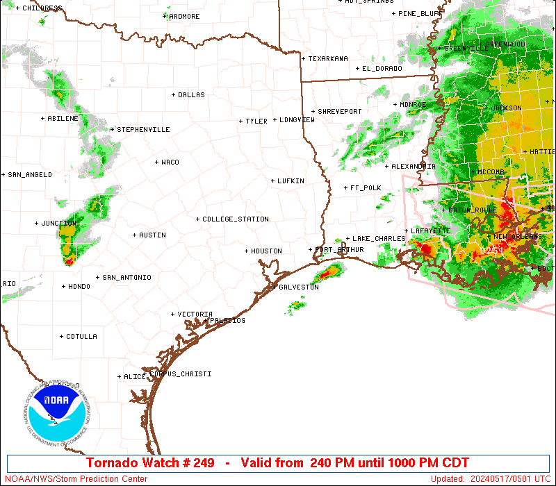
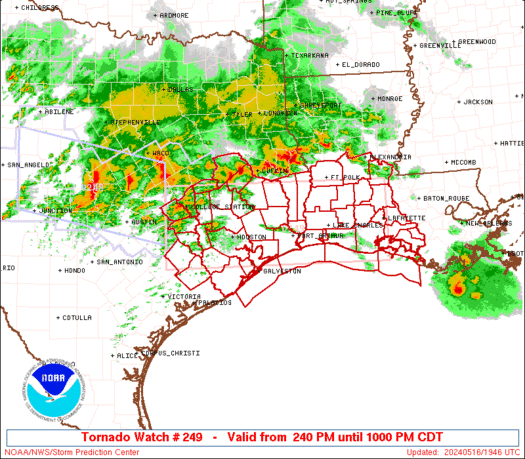
Tornado Watch Number 249
NWS Storm Prediction Center Norman OK
240 PM CDT Thu May 16 2024
The NWS Storm Prediction Center has issued a
* Tornado Watch for portions of
Southwest Louisiana
Southeast Texas
Coastal Waters
* Effective this Thursday afternoon and evening from 240 PM until
1000 PM CDT.
* Primary threats include...
A couple tornadoes possible
Scattered damaging wind gusts to 70 mph likely
Scattered large hail and isolated very large hail events to 2
inches in diameter possible
SUMMARY...Clusters of storms will continue to develop and spread
east-southeastward through early tonight along a composite outflow
boundary sagging southward across east Texas. The potential for
supercells with large hail of 1-2 inches in diameter and a couple of
tornadoes will increase with new storm development south of the
outflow. Otherwise, embedded supercells and bowing segments will
pose a threat for damaging winds of 60-70 mph, as well as a couple
of tornadoes with embedded circulations.
The tornado watch area is approximately along and 55 statute miles
north and south of a line from 40 miles southwest of College Station
TX to 5 miles east southeast of Lafayette LA. For a complete
depiction of the watch see the associated watch outline update
(WOUS64 KWNS WOU9).
PRECAUTIONARY/PREPAREDNESS ACTIONS...
REMEMBER...A Tornado Watch means conditions are favorable for
tornadoes and severe thunderstorms in and close to the watch
area. Persons in these areas should be on the lookout for
threatening weather conditions and listen for later statements
and possible warnings.
&&
OTHER WATCH INFORMATION...CONTINUE...WW 248...
AVIATION...Tornadoes and a few severe thunderstorms with hail
surface and aloft to 2 inches. Extreme turbulence and surface wind
gusts to 60 knots. A few cumulonimbi with maximum tops to 600. Mean
storm motion vector 28030.
...Thompson

   SEL9

   URGENT - IMMEDIATE BROADCAST REQUESTED
   Tornado Watch Number 249
   NWS Storm Prediction Center Norman OK
   240 PM CDT Thu May 16 2024

   The NWS Storm Prediction Center has issued a

   * Tornado Watch for portions of
     Southwest Louisiana
     Southeast Texas
     Coastal Waters

   * Effective this Thursday afternoon and evening from 240 PM until
     1000 PM CDT.

   * Primary threats include...
     A couple tornadoes possible
     Scattered damaging wind gusts to 70 mph likely
     Scattered large hail and isolated very large hail events to 2
       inches in diameter possible

   SUMMARY...Clusters of storms will continue to develop and spread
   east-southeastward through early tonight along a composite outflow
   boundary sagging southward across east Texas.  The potential for
   supercells with large hail of 1-2 inches in diameter and a couple of
   tornadoes will increase with new storm development south of the
   outflow.  Otherwise, embedded supercells and bowing segments will
   pose a threat for damaging winds of 60-70 mph, as well as a couple
   of tornadoes with embedded circulations.

   The tornado watch area is approximately along and 55 statute miles
   north and south of a line from 40 miles southwest of College Station
   TX to 5 miles east southeast of Lafayette LA. For a complete
   depiction of the watch see the associated watch outline update
   (WOUS64 KWNS WOU9).

   PRECAUTIONARY/PREPAREDNESS ACTIONS...

   REMEMBER...A Tornado Watch means conditions are favorable for
   tornadoes and severe thunderstorms in and close to the watch
   area. Persons in these areas should be on the lookout for
   threatening weather conditions and listen for later statements
   and possible warnings.

   &&

   OTHER WATCH INFORMATION...CONTINUE...WW 248...

   AVIATION...Tornadoes and a few severe thunderstorms with hail
   surface and aloft to 2 inches. Extreme turbulence and surface wind
   gusts to 60 knots. A few cumulonimbi with maximum tops to 600. Mean
   storm motion vector 28030.

   ...Thompson
 Note:
The Aviation Watch (SAW) product is an approximation to the watch area.
The actual watch is depicted by the shaded areas.
Note:
The Aviation Watch (SAW) product is an approximation to the watch area.
The actual watch is depicted by the shaded areas.
   SAW9
   WW 249 TORNADO LA TX CW 161940Z - 170300Z
   AXIS..55 STATUTE MILES NORTH AND SOUTH OF LINE..
   40SW CLL/COLLEGE STATION TX/ - 5ESE LFT/LAFAYETTE LA/
   ..AVIATION COORDS.. 50NM N/S /38ESE CWK - 36WSW BTR/
   HAIL SURFACE AND ALOFT..2 INCHES. WIND GUSTS..60 KNOTS.
   MAX TOPS TO 600. MEAN STORM MOTION VECTOR 28030.

   LAT...LON 30979684 30979190 29389190 29379684

   THIS IS AN APPROXIMATION TO THE WATCH AREA.  FOR A
   COMPLETE DEPICTION OF THE WATCH SEE WOUS64 KWNS
   FOR WOU9.
Watch 249 Status Report Messages:
STATUS REPORT #3 ON WW 249

VALID 170150Z - 170240Z

SEVERE WEATHER THREAT CONTINUES RIGHT OF A LINE FROM 5 NE GLS TO
20 NE LCH TO 15 ESE POE.

..SPC..05/17/24

ATTN...WFO...LCH...HGX...

&&

STATUS REPORT FOR WT 249

SEVERE WEATHER THREAT CONTINUES FOR THE FOLLOWING AREAS

LAC001-003-019-023-039-045-053-055-097-099-101-113-170240-

LA
.    LOUISIANA PARISHES INCLUDED ARE

ACADIA		     ALLEN		 CALCASIEU
CAMERON 	     EVANGELINE 	 IBERIA
JEFFERSON DAVIS      LAFAYETTE		 ST. LANDRY
ST. MARTIN	     ST. MARY		 VERMILION
$$


TXC039-071-167-245-170240-

TX
.    TEXAS COUNTIES INCLUDED ARE

BRAZORIA	     CHAMBERS		 GALVESTON
JEFFERSON
$$


GMZ335-355-430-432-435-436-450-452-455-170240-

CW

.    ADJACENT COASTAL WATERS INCLUDED ARE

GALVESTON BAY

COASTAL WATERS FROM HIGH ISLAND TO FREEPORT TX OUT 20 NM

SABINE LAKE

CALCASIEU LAKE

VERMILION BAY


COASTAL WATERS FROM CAMERON LA TO HIGH ISLAND TX OUT 20 NM

COASTAL WATERS FROM INTRACOASTAL CITY TO CAMERON LA OUT 20 NM

COASTAL WATERS FROM LOWER ATCHAFALAYA RIVER TO INTRACOASTAL CITY
LA OUT 20 NM

$$
THE WATCH STATUS MESSAGE IS FOR GUIDANCE PURPOSES ONLY.  PLEASE
REFER TO WATCH COUNTY NOTIFICATION STATEMENTS FOR OFFICIAL
INFORMATION ON COUNTIES...INDEPENDENT CITIES AND MARINE ZONES
CLEARED FROM SEVERE THUNDERSTORM AND TORNADO WATCHES.
$$

STATUS REPORT #2 ON WW 249

VALID 170005Z - 170140Z

SEVERE WEATHER THREAT CONTINUES RIGHT OF A LINE FROM 40 WNW LBX
TO 30 N HOU TO 40 W POE.

..SPC..05/17/24

ATTN...WFO...LCH...HGX...

&&

STATUS REPORT FOR WT 249

SEVERE WEATHER THREAT CONTINUES FOR THE FOLLOWING AREAS

LAC001-003-009-011-019-023-039-045-053-055-079-097-099-101-113-
115-170140-

LA
.    LOUISIANA PARISHES INCLUDED ARE

ACADIA		     ALLEN		 AVOYELLES
BEAUREGARD	     CALCASIEU		 CAMERON
EVANGELINE	     IBERIA		 JEFFERSON DAVIS
LAFAYETTE	     RAPIDES		 ST. LANDRY
ST. MARTIN	     ST. MARY		 VERMILION
VERNON
$$


TXC039-071-157-167-199-201-241-245-291-351-361-457-481-170140-

TX
.    TEXAS COUNTIES INCLUDED ARE

BRAZORIA	     CHAMBERS		 FORT BEND
GALVESTON	     HARDIN		 HARRIS
JASPER		     JEFFERSON		 LIBERTY
NEWTON		     ORANGE		 TYLER
WHARTON
$$


GMZ335-355-430-432-435-436-450-452-455-170140-

CW

.    ADJACENT COASTAL WATERS INCLUDED ARE

GALVESTON BAY

COASTAL WATERS FROM HIGH ISLAND TO FREEPORT TX OUT 20 NM

SABINE LAKE

CALCASIEU LAKE

VERMILION BAY


COASTAL WATERS FROM CAMERON LA TO HIGH ISLAND TX OUT 20 NM

COASTAL WATERS FROM INTRACOASTAL CITY TO CAMERON LA OUT 20 NM

COASTAL WATERS FROM LOWER ATCHAFALAYA RIVER TO INTRACOASTAL CITY
LA OUT 20 NM

$$
THE WATCH STATUS MESSAGE IS FOR GUIDANCE PURPOSES ONLY.  PLEASE
REFER TO WATCH COUNTY NOTIFICATION STATEMENTS FOR OFFICIAL
INFORMATION ON COUNTIES...INDEPENDENT CITIES AND MARINE ZONES
CLEARED FROM SEVERE THUNDERSTORM AND TORNADO WATCHES.
$$

STATUS REPORT #1 ON WW 249

VALID 162240Z - 162340Z

SEVERE WEATHER THREAT CONTINUES RIGHT OF A LINE FROM 55 N VCT TO
30 S CLL TO 30 NNE CLL.

..SPC..05/16/24

ATTN...WFO...LCH...HGX...

&&

STATUS REPORT FOR WT 249

SEVERE WEATHER THREAT CONTINUES FOR THE FOLLOWING AREAS

LAC001-003-009-011-019-023-039-045-053-055-079-097-099-101-113-
115-162340-

LA
.    LOUISIANA PARISHES INCLUDED ARE

ACADIA		     ALLEN		 AVOYELLES
BEAUREGARD	     CALCASIEU		 CAMERON
EVANGELINE	     IBERIA		 JEFFERSON DAVIS
LAFAYETTE	     RAPIDES		 ST. LANDRY
ST. MARTIN	     ST. MARY		 VERMILION
VERNON
$$


TXC015-039-041-071-089-157-167-185-199-201-241-245-291-313-339-
351-361-373-407-457-471-473-477-481-162340-

TX
.    TEXAS COUNTIES INCLUDED ARE

AUSTIN		     BRAZORIA		 BRAZOS
CHAMBERS	     COLORADO		 FORT BEND
GALVESTON	     GRIMES		 HARDIN
HARRIS		     JASPER		 JEFFERSON
LIBERTY 	     MADISON		 MONTGOMERY
NEWTON		     ORANGE		 POLK
SAN JACINTO	     TYLER		 WALKER
WALLER		     WASHINGTON 	 WHARTON
$$


GMZ335-355-430-432-435-436-450-452-455-162340-

CW

.    ADJACENT COASTAL WATERS INCLUDED ARE

GALVESTON BAY

COASTAL WATERS FROM HIGH ISLAND TO FREEPORT TX OUT 20 NM

SABINE LAKE

CALCASIEU LAKE

VERMILION BAY


COASTAL WATERS FROM CAMERON LA TO HIGH ISLAND TX OUT 20 NM

COASTAL WATERS FROM INTRACOASTAL CITY TO CAMERON LA OUT 20 NM

COASTAL WATERS FROM LOWER ATCHAFALAYA RIVER TO INTRACOASTAL CITY
LA OUT 20 NM

$$
THE WATCH STATUS MESSAGE IS FOR GUIDANCE PURPOSES ONLY.  PLEASE
REFER TO WATCH COUNTY NOTIFICATION STATEMENTS FOR OFFICIAL
INFORMATION ON COUNTIES...INDEPENDENT CITIES AND MARINE ZONES
CLEARED FROM SEVERE THUNDERSTORM AND TORNADO WATCHES.
$$
Note:
Click for Complete Product Text.
Tornadoes
Probability of 2 or more tornadoes
|
Mod (40%)
|
Probability of 1 or more strong (EF2-EF5) tornadoes
|
Low (20%)
|
Wind
Probability of 10 or more severe wind events
|
Mod (60%)
|
Probability of 1 or more wind events > 65 knots
|
Low (20%)
|
Hail
Probability of 10 or more severe hail events
|
Mod (40%)
|
Probability of 1 or more hailstones > 2 inches
|
Mod (30%)
|
Combined Severe Hail/Wind
Probability of 6 or more combined severe hail/wind events
|
High (90%)
|
For each watch, probabilities for particular events inside the watch
(listed above in each table) are determined by the issuing forecaster.
The "Low" category contains probability values ranging from less than 2%
to 20% (EF2-EF5 tornadoes), less than 5% to 20% (all other probabilities),
"Moderate" from 30% to 60%, and "High" from 70% to greater than 95%.
High values are bolded and lighter in color to provide awareness of
an increased threat for a particular event.


 @NWSSPC