|
| Mesoscale Discussion 768 |
|
< Previous MD Next MD >
|
|
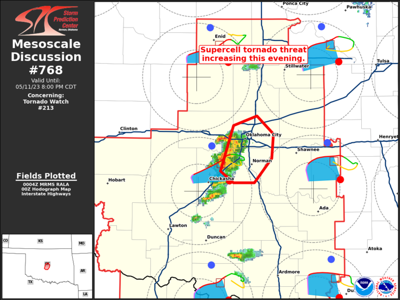
   Mesoscale Discussion 0768
   NWS Storm Prediction Center Norman OK
   0707 PM CDT Thu May 11 2023

   Areas affected...Parts of central Oklahoma

   Concerning...Tornado Watch 213...

   Valid 120007Z - 120100Z

   The severe weather threat for Tornado Watch 213 continues.

   SUMMARY...The supercell tornado threat is increasing and likely
   peaking in the next one to two hours for parts of the southern OKC
   metro.

   DISCUSSION...After several storm mergers in Grady County, latest
   KTLX radar imagery shows a couple consolidating supercell structures
   with more-organized mesocyclones in Canadian and Grady Counties. The
   near-storm environment is becoming increasingly favorable for
   sustained supercells, with expanding clockwise-turning hodographs
   (around 150 m2/s2 0-1km SRH from KTLX VAD and increasing) and lower
   70s boundary-layer dewpoints. Given slightly larger supercell
   structures moving into this environment, the supercell tornado risk
   is increasing and likely peaking in the next hour or two.

   ..Weinman.. 05/12/2023

   ...Please see www.spc.noaa.gov for graphic product...

   ATTN...WFO...OUN...

   LAT...LON   35059767 35169781 35599767 35679739 35519721 35289723
               35049742 35059767
|
|
Top/All Mesoscale Discussions/Forecast Products/Home
|
|


 @NWSSPC