|
| Mesoscale Discussion 48 |
|
< Previous MD Next MD >
|
|
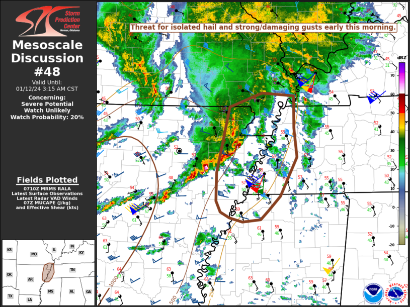
   Mesoscale Discussion 0048
   NWS Storm Prediction Center Norman OK
   0113 AM CST Fri Jan 12 2024

   Areas affected...Northeast AR...Western TN...Extreme northwest
   MS...MO Bootheel region

   Concerning...Severe potential...Watch unlikely

   Valid 120713Z - 120915Z

   Probability of Watch Issuance...20 percent

   SUMMARY...Some threat for isolated hail and strong/damaging gusts is
   expected early this morning. Short-term watch issuance is unlikely,
   though another round of potentially severe storms is expected later
   this morning.

   DISCUSSION...Multiple bowing storm clusters are moving across
   east-central/northeast AR early this morning, with observed wind
   gusts in the 40-45 kt (with one 54 kt gust recently noted at KARG in
   the wake of the line) and potentially large hail noted in MRMS data.
   These storms are generally northeast of the primary low-level moist
   axis, and will likely continue to be somewhat elevated as they move
   east-northeastward toward western TN and the MO Bootheel region.
   However, steepening midlevel lapse rates and strong deep-layer
   flow/shear (as noted in the 06Z LZK sounding and regional VWPs) in
   advance of a strong mid/upper-level shortwave trough will continue
   to support organized convection early this morning, with some threat
   for isolated hail and strong/damaging gusts.

   Given the somewhat elevated nature of the ongoing storms and a
   likely tendency for this convection to move out of the primary
   instability axis, short-term watch issuance is unlikely. However,
   another round of organized convection is expected later this
   morning, as the upstream shortwave and its attendant strong forcing
   and powerful flow fields overspread the region.

   ..Dean/Edwards.. 01/12/2024

   ...Please see www.spc.noaa.gov for graphic product...

   ATTN...WFO...PAH...MEG...

   LAT...LON   36499058 36728991 36678924 36138923 35628917 34958952
               34728977 34558993 34519031 34599059 34689077 34889087
               35359086 36499058
|
|
Top/All Mesoscale Discussions/Forecast Products/Home
|
|


 @NWSSPC