|
| Mesoscale Discussion 56 |
|
< Previous MD Next MD >
|
|
Mesoscale Discussion 0056
NWS Storm Prediction Center Norman OK
0229 PM CST Fri Jan 12 2024
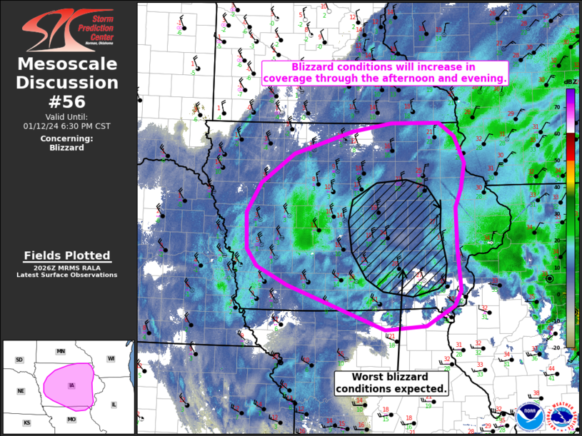
Areas affected...Iowa
Concerning...Blizzard
Valid 122029Z - 130030Z
SUMMARY...Blizzard conditions will become more widespread through
the afternoon and evening across portions of Iowa.
DISCUSSION...The primary surface low continues to track to the
northeast with recent surface observations/analyses depicting the
center of the low over central IL. To the west/northwest of the low,
a cold air mass continues to push southward across IA. Gradient
winds have slowly been increasing with the approach and deepening of
the low. While sustained winds have largely remained below 35 mph
thus far, frequent gusts between 30-40 mph have been observed across
IA with subsequent visibility reductions down to 1/4 mile. Winds are
forecast to peak around 00 UTC with frequent gusts between 35-45 mph
likely. Although snowfall should gradually diminish through the
evening, a fresh, 2+ inch snow pack is in place across much of the
state per recent LSRs. Blowing snow model output indicates that this
combination of winds, a fresh/deep snow pack, and temperatures in
the teens will support scattered to widespread blizzard conditions
with prolonged visibility reductions of 1/4 mile or less. Based on
recent hi-res guidance, portions of central/eastern IA may see wind
gusts up to 50-55 mph over a 4-10 inch deep snow pack, resulting in
a corridor of fairly intense blizzard conditions with near-zero
visibilities possible.
..Moore.. 01/12/2024
...Please see www.spc.noaa.gov for graphic product...
ATTN...WFO...DVN...ARX...DMX...EAX...FSD...OAX...
LAT...LON 42569536 42099566 41539565 41269543 40969480 40269277
40339192 40639135 40879120 41539128 42179129 42469118
42879110 43299131 43509162 43499262 43369346 43029467
42569536
|
|
Top/All Mesoscale Discussions/Forecast Products/Home
|
|


 @NWSSPC