|
| Mesoscale Discussion 334 |
|
< Previous MD Next MD >
|
|
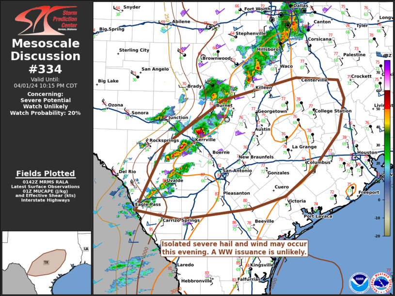
   Mesoscale Discussion 0334
   NWS Storm Prediction Center Norman OK
   0844 PM CDT Mon Apr 01 2024

   Areas affected...portions of central into southern Texas

   Concerning...Severe potential...Watch unlikely

   Valid 020144Z - 020315Z

   Probability of Watch Issuance...20 percent

   SUMMARY...Strong thunderstorms are ongoing across portions of
   central and southern TX ahead of the cold front. Large hail and
   damaging gusts are the main threat with the more intense storms. A
   WW issuance is unlikely since the severe threat should remain
   isolated.

   DISCUSSION...Multicellular storms and transient supercells have
   developed ahead of a cold front across central into southern TX
   toward the Rio Grande, and are poised to move eastward into an
   increasingly buoyant airmass. Upper 70s to low 80s F surface
   temperatures and 70+ F dewpoints beneath 7-8 C/km mid-level lapse
   rates are contributing to 1000-1500 J/kg MLCAPE (per 01Z
   mesoanalysis). Regional VADs and 01Z mesoanalysis show elongated
   hodographs with some low-level curvature, but also considerable CINH
   in the 850-700 mb layer (as also shown by RAP forecast soundings).
   Furthermore, regional radar data suggests that many of these storms
   are anafrontal, and are occurring in a region of weaker deep-layer
   ascent compared to areas farther north. Large hail and damaging
   gusts may occur with some of the stronger storms if they can mature
   and sustain themselves this evening. A WW issuance appears unlikely
   since the overall severe threat should remain isolated.

   ..Squitieri/Hart.. 04/02/2024

   ...Please see www.spc.noaa.gov for graphic product...

   ATTN...WFO...HGX...FWD...CRP...EWX...SJT...

   LAT...LON   28660046 29999980 30929845 31389674 31329574 30939560
               30259576 29489636 28969700 28719778 28489944 28660046
|
|
Top/All Mesoscale Discussions/Forecast Products/Home
|
|


 @NWSSPC