|
| Mesoscale Discussion 357 |
|
< Previous MD Next MD >
|
|
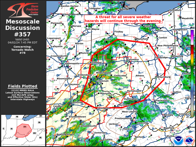
   Mesoscale Discussion 0357
   NWS Storm Prediction Center Norman OK
   0515 PM CDT Tue Apr 02 2024

   Areas affected...southern and central Ohio...northern Kentucky...and
   northern West Virginia.

   Concerning...Tornado Watch 78...

   Valid 022215Z - 022345Z

   The severe weather threat for Tornado Watch 78 continues.

   SUMMARY...A threat for all severe weather hazards will continue
   through the evening.

   DISCUSSION...Several supercells with a history of tornadoes are
   moving into southwest Ohio. These supercells will continue to pose a
   tornado threat as they move east across southern Ohio. Additional
   development is ongoing ahead of this activity which may also pose a
   tornado threat as storms mature. The 21Z ILN RAOB shows an uncapped,
   moderately unstable atmosphere with low-level shear favorable for
   tornadoes and some strong tornadoes. Expect a similar environment to
   spread across much of eastern and central Ohio over the next few
   hours as airmass recovery continues in the wake of earlier
   convection. In addition, winds have backed across Ohio with strong
   pressure falls in response to the rapidly deepening surface low near
   southern Lake Michigan which will continue to support a tornado
   threat.

   The greatest tornado threat is expected south of I-70 in Ohio where
   dewpoints of 63 to 65F and greater instability will support a
   greater tornado threat amid favorable low-level shear.

   Expansion of tornado watch 78 will be needed with an additional
   tornado watch likely across much of southern, eastern, and
   potentially northern Ohio.

   ..Bentley/Guyer.. 04/02/2024

   ...Please see www.spc.noaa.gov for graphic product...

   ATTN...WFO...PBZ...RLX...CLE...JKL...ILN...LMK...

   LAT...LON   38428530 39158498 40168472 40808346 40648182 39638104
               39228112 38428216 38138324 38138457 38428530
|
|
Top/All Mesoscale Discussions/Forecast Products/Home
|
|


 @NWSSPC