|
| Mesoscale Discussion 416 |
|
< Previous MD Next MD >
|
|
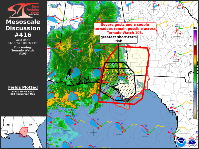
   Mesoscale Discussion 0416
   NWS Storm Prediction Center Norman OK
   0332 PM CDT Wed Apr 10 2024

   Areas affected...southeast Alabama...southwest Georgia and the
   Florida Panhandle

   Concerning...Tornado Watch 103...

   Valid 102032Z - 102200Z

   The severe weather threat for Tornado Watch 103 continues.

   SUMMARY...Damaging gusts and a couple of tornadoes remain possible
   across Tornado Watch 103. The greatest risk will likely remain
   closer to the Gulf Coast and over the Florida Panhandle in the short
   term.

   DISCUSSION...A line of strong to severe storms will continue to
   shift east across the FL Panhandle into far southeast AL and
   southwest GA the next few hours. Boundary-layer moisture has
   remained modest, with dewpoints currently around 59-62 F across far
   southeast AL into southwest GA. Moisture does increase with
   southward extent across the FL Panhandle to the coast with mid/upper
   60s F dewpoints noted. Limited heating through the afternoon also
   has limited low-level lapse rates and greater destabilization with
   northward extent. The corridor of greater instability will likely
   remain confined to the immediate coast and FL Panhandle vicinity.
   Nevertheless, deep shear remain strong and will likely help to
   maintain an organized line with eastward extent. Damaging gusts and
   a tornado or two remain possible the next couple of hours.

   ..Leitman.. 04/10/2024

   ...Please see www.spc.noaa.gov for graphic product...

   ATTN...WFO...FFC...TAE...BMX...MOB...

   LAT...LON   31938538 31868406 31578398 29708433 29468472 29558650
               30958633 31558592 31938554 31938538
|
|
Top/All Mesoscale Discussions/Forecast Products/Home
|
|


 @NWSSPC