 Note:
The expiration time in the watch graphic is amended if the watch is
replaced, cancelled or extended.
Note:
Note:
The expiration time in the watch graphic is amended if the watch is
replaced, cancelled or extended.
Note: Click for
Watch Status Reports.
SEL1
URGENT - IMMEDIATE BROADCAST REQUESTED
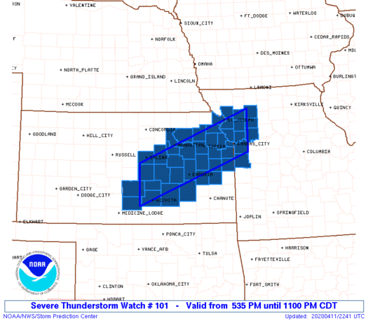
Severe Thunderstorm Watch Number 101
NWS Storm Prediction Center Norman OK
535 PM CDT Sat Apr 11 2020
The NWS Storm Prediction Center has issued a
* Severe Thunderstorm Watch for portions of
Central and Eastern Kansas
Northwest Missouri
* Effective this Saturday afternoon and evening from 535 PM until
1100 PM CDT.
* Primary threats include...
Scattered large hail and isolated very large hail events to 2
inches in diameter possible
Isolated damaging wind gusts to 70 mph possible
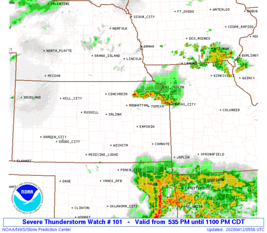
SUMMARY...Thunderstorms are expected to develop and intensify across
parts of central Kansas early this evening and spread eastward
across the watch area. Large hail and gusty winds will be possible
in the more intense storms.
The severe thunderstorm watch area is approximately along and 40
statute miles north and south of a line from Hutchinson KS to 35
miles northeast of Kansas City MO. For a complete depiction of the
watch see the associated watch outline update (WOUS64 KWNS WOU1).
PRECAUTIONARY/PREPAREDNESS ACTIONS...
REMEMBER...A Severe Thunderstorm Watch means conditions are
favorable for severe thunderstorms in and close to the watch area.
Persons in these areas should be on the lookout for threatening
weather conditions and listen for later statements and possible
warnings. Severe thunderstorms can and occasionally do produce
tornadoes.
&&
OTHER WATCH INFORMATION...CONTINUE...WW 100...
AVIATION...A few severe thunderstorms with hail surface and aloft to
2 inches. Extreme turbulence and surface wind gusts to 60 knots. A
few cumulonimbi with maximum tops to 500. Mean storm motion vector
26025.
...Hart
 Note:
The Aviation Watch (SAW) product is an approximation to the watch area.
The actual watch is depicted by the shaded areas.
Note:
The Aviation Watch (SAW) product is an approximation to the watch area.
The actual watch is depicted by the shaded areas.
   SAW1
   WW 101 SEVERE TSTM KS MO 112235Z - 120400Z
   AXIS..40 STATUTE MILES NORTH AND SOUTH OF LINE..
   HUT/HUTCHINSON KS/ - 35NE MKC/KANSAS CITY MO/
   ..AVIATION COORDS.. 35NM N/S /24NW ICT - 30ENE MCI/
   HAIL SURFACE AND ALOFT..2 INCHES. WIND GUSTS..60 KNOTS.
   MAX TOPS TO 500. MEAN STORM MOTION VECTOR 26025.

   LAT...LON 38659787 40059414 38899414 37499787

   THIS IS AN APPROXIMATION TO THE WATCH AREA.  FOR A
   COMPLETE DEPICTION OF THE WATCH SEE WOUS64 KWNS
   FOR WOU1.
Watch 101 Status Report Messages:
STATUS REPORT #5 ON WW 101

VALID 120325Z - 120440Z

SEVERE WEATHER THREAT CONTINUES RIGHT OF A LINE FROM CDJ TO 35
WSW CDJ TO 15 WSW FLV TO 30 E MHK TO 5 NW MHK TO 25 WNW MHK.

..COOK..04/12/20

ATTN...WFO...TOP...EAX...ICT...

&&

STATUS REPORT FOR WS 101

SEVERE WEATHER THREAT CONTINUES FOR THE FOLLOWING AREAS

KSC005-043-085-087-149-120440-

KS
.    KANSAS COUNTIES INCLUDED ARE

ATCHISON	     DONIPHAN		 JACKSON
JEFFERSON	     POTTAWATOMIE
$$


MOC003-021-025-049-061-063-075-081-087-147-165-227-120440-

MO
.    MISSOURI COUNTIES INCLUDED ARE

ANDREW		     BUCHANAN		 CALDWELL
CLINTON 	     DAVIESS		 DEKALB
GENTRY		     HARRISON		 HOLT
NODAWAY 	     PLATTE		 WORTH
$$


THE WATCH STATUS MESSAGE IS FOR GUIDANCE PURPOSES ONLY.  PLEASE
REFER TO WATCH COUNTY NOTIFICATION STATEMENTS FOR OFFICIAL
INFORMATION ON COUNTIES...INDEPENDENT CITIES AND MARINE ZONES
CLEARED FROM SEVERE THUNDERSTORM AND TORNADO WATCHES.
$$

STATUS REPORT #4 ON WW 101

VALID 120230Z - 120340Z

SEVERE WEATHER THREAT CONTINUES RIGHT OF A LINE FROM 25 NW CNU TO
5 ESE EMP TO 20 SE MHK TO 35 N MHK.

..COOK..04/12/20

ATTN...WFO...TOP...EAX...ICT...

&&

STATUS REPORT FOR WS 101

SEVERE WEATHER THREAT CONTINUES FOR THE FOLLOWING AREAS

KSC003-005-031-043-045-059-085-087-091-103-111-121-139-149-177-
197-209-120340-

KS
.    KANSAS COUNTIES INCLUDED ARE

ANDERSON	     ATCHISON		 COFFEY
DONIPHAN	     DOUGLAS		 FRANKLIN
JACKSON 	     JEFFERSON		 JOHNSON
LEAVENWORTH	     LYON		 MIAMI
OSAGE		     POTTAWATOMIE	 SHAWNEE
WABAUNSEE	     WYANDOTTE
$$


MOC003-021-025-037-047-049-061-063-075-087-095-147-165-177-
120340-

MO
.    MISSOURI COUNTIES INCLUDED ARE

ANDREW		     BUCHANAN		 CALDWELL
CASS		     CLAY		 CLINTON
DAVIESS 	     DEKALB		 GENTRY
HOLT		     JACKSON		 NODAWAY
PLATTE		     RAY
$$


THE WATCH STATUS MESSAGE IS FOR GUIDANCE PURPOSES ONLY.  PLEASE
REFER TO WATCH COUNTY NOTIFICATION STATEMENTS FOR OFFICIAL
INFORMATION ON COUNTIES...INDEPENDENT CITIES AND MARINE ZONES
CLEARED FROM SEVERE THUNDERSTORM AND TORNADO WATCHES.
$$

STATUS REPORT #3 ON WW 101

VALID 120130Z - 120240Z

SEVERE WEATHER THREAT CONTINUES RIGHT OF A LINE FROM 55 E ICT TO
35 SW EMP TO 30 S MHK TO 35 N MHK.

FOR ADDITIONAL INFORMATION SEE MESOSCALE DISCUSSION 340

..COOK..04/12/20

ATTN...WFO...TOP...EAX...ICT...

&&

STATUS REPORT FOR WS 101

SEVERE WEATHER THREAT CONTINUES FOR THE FOLLOWING AREAS

KSC003-005-017-031-043-045-059-061-073-085-087-091-103-111-121-
127-139-149-161-177-197-209-120240-

KS
.    KANSAS COUNTIES INCLUDED ARE

ANDERSON	     ATCHISON		 CHASE
COFFEY		     DONIPHAN		 DOUGLAS
FRANKLIN	     GEARY		 GREENWOOD
JACKSON 	     JEFFERSON		 JOHNSON
LEAVENWORTH	     LYON		 MIAMI
MORRIS		     OSAGE		 POTTAWATOMIE
RILEY		     SHAWNEE		 WABAUNSEE
WYANDOTTE
$$


MOC003-021-025-037-047-049-061-063-095-165-177-120240-

MO
.    MISSOURI COUNTIES INCLUDED ARE

ANDREW		     BUCHANAN		 CALDWELL
CASS		     CLAY		 CLINTON
DAVIESS 	     DEKALB		 JACKSON
PLATTE		     RAY
$$


THE WATCH STATUS MESSAGE IS FOR GUIDANCE PURPOSES ONLY.  PLEASE
REFER TO WATCH COUNTY NOTIFICATION STATEMENTS FOR OFFICIAL
INFORMATION ON COUNTIES...INDEPENDENT CITIES AND MARINE ZONES
CLEARED FROM SEVERE THUNDERSTORM AND TORNADO WATCHES.
$$

STATUS REPORT #2 ON WW 101

VALID 120030Z - 120140Z

THE SEVERE WEATHER THREAT CONTINUES ACROSS THE ENTIRE WATCH AREA.

..COOK..04/12/20

ATTN...WFO...TOP...EAX...ICT...

&&

STATUS REPORT FOR WS 101

SEVERE WEATHER THREAT CONTINUES FOR THE FOLLOWING AREAS

KSC003-005-015-017-031-041-043-045-059-061-073-079-085-087-091-
095-103-111-113-115-121-127-139-149-155-161-169-173-177-197-209-
120140-

KS
.    KANSAS COUNTIES INCLUDED ARE

ANDERSON	     ATCHISON		 BUTLER
CHASE		     COFFEY		 DICKINSON
DONIPHAN	     DOUGLAS		 FRANKLIN
GEARY		     GREENWOOD		 HARVEY
JACKSON 	     JEFFERSON		 JOHNSON
KINGMAN 	     LEAVENWORTH	 LYON
MCPHERSON	     MARION		 MIAMI
MORRIS		     OSAGE		 POTTAWATOMIE
RENO		     RILEY		 SALINE
SEDGWICK	     SHAWNEE		 WABAUNSEE
WYANDOTTE
$$


MOC003-021-025-037-047-049-061-063-095-165-177-120140-

MO
.    MISSOURI COUNTIES INCLUDED ARE

ANDREW		     BUCHANAN		 CALDWELL
CASS		     CLAY		 CLINTON
DAVIESS 	     DEKALB		 JACKSON
PLATTE		     RAY
$$


THE WATCH STATUS MESSAGE IS FOR GUIDANCE PURPOSES ONLY.  PLEASE
REFER TO WATCH COUNTY NOTIFICATION STATEMENTS FOR OFFICIAL
INFORMATION ON COUNTIES...INDEPENDENT CITIES AND MARINE ZONES
CLEARED FROM SEVERE THUNDERSTORM AND TORNADO WATCHES.
$$

STATUS REPORT #1 ON WW 101

VALID 112335Z - 120040Z

THE SEVERE WEATHER THREAT CONTINUES ACROSS THE ENTIRE WATCH AREA.

..COOK..04/11/20

ATTN...WFO...TOP...EAX...ICT...

&&

STATUS REPORT FOR WS 101

SEVERE WEATHER THREAT CONTINUES FOR THE FOLLOWING AREAS

KSC003-005-015-017-031-041-043-045-059-061-073-079-085-087-091-
095-103-111-113-115-121-127-139-149-155-161-169-173-177-197-209-
120040-

KS
.    KANSAS COUNTIES INCLUDED ARE

ANDERSON	     ATCHISON		 BUTLER
CHASE		     COFFEY		 DICKINSON
DONIPHAN	     DOUGLAS		 FRANKLIN
GEARY		     GREENWOOD		 HARVEY
JACKSON 	     JEFFERSON		 JOHNSON
KINGMAN 	     LEAVENWORTH	 LYON
MCPHERSON	     MARION		 MIAMI
MORRIS		     OSAGE		 POTTAWATOMIE
RENO		     RILEY		 SALINE
SEDGWICK	     SHAWNEE		 WABAUNSEE
WYANDOTTE
$$


MOC003-021-025-037-047-049-061-063-095-165-177-120040-

MO
.    MISSOURI COUNTIES INCLUDED ARE

ANDREW		     BUCHANAN		 CALDWELL
CASS		     CLAY		 CLINTON
DAVIESS 	     DEKALB		 JACKSON
PLATTE		     RAY
$$


THE WATCH STATUS MESSAGE IS FOR GUIDANCE PURPOSES ONLY.  PLEASE
REFER TO WATCH COUNTY NOTIFICATION STATEMENTS FOR OFFICIAL
INFORMATION ON COUNTIES...INDEPENDENT CITIES AND MARINE ZONES
CLEARED FROM SEVERE THUNDERSTORM AND TORNADO WATCHES.
$$
Note:
Click for Complete Product Text.
Tornadoes
Probability of 2 or more tornadoes
|
Low (<5%)
|
Probability of 1 or more strong (EF2-EF5) tornadoes
|
Low (<2%)
|
Wind
Probability of 10 or more severe wind events
|
Low (20%)
|
Probability of 1 or more wind events > 65 knots
|
Low (10%)
|
Hail
Probability of 10 or more severe hail events
|
Mod (40%)
|
Probability of 1 or more hailstones > 2 inches
|
Mod (30%)
|
Combined Severe Hail/Wind
Probability of 6 or more combined severe hail/wind events
|
High (70%)
|
For each watch, probabilities for particular events inside the watch
(listed above in each table) are determined by the issuing forecaster.
The "Low" category contains probability values ranging from less than 2%
to 20% (EF2-EF5 tornadoes), less than 5% to 20% (all other probabilities),
"Moderate" from 30% to 60%, and "High" from 70% to greater than 95%.
High values are bolded and lighter in color to provide awareness of
an increased threat for a particular event.


 @NWSSPC


