 Note:
The expiration time in the watch graphic is amended if the watch is
replaced, cancelled or extended.
Note:
Note:
The expiration time in the watch graphic is amended if the watch is
replaced, cancelled or extended.
Note: Click for
Watch Status Reports.
SEL0
URGENT - IMMEDIATE BROADCAST REQUESTED
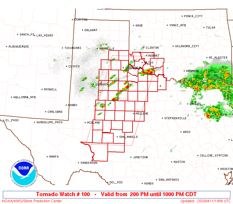
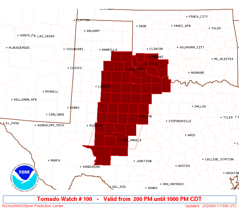
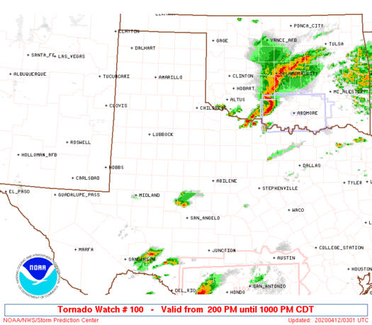
Tornado Watch Number 100
NWS Storm Prediction Center Norman OK
200 PM CDT Sat Apr 11 2020
The NWS Storm Prediction Center has issued a
* Tornado Watch for portions of
Southwest Oklahoma
Western and northwest Texas
* Effective this Saturday afternoon and evening from 200 PM until
1000 PM CDT.
* Primary threats include...
A few tornadoes likely
Scattered large hail and isolated very large hail events to 3
inches in diameter likely
Scattered damaging wind gusts to 70 mph possible
SUMMARY...Scattered thunderstorms will gradually intensify along and
ahead of the dryline into the early evening. Some of these will
develop into supercells with the primary hazards being very large
hail and a few tornadoes.
The tornado watch area is approximately along and 70 statute miles
east and west of a line from 35 miles southwest of San Angelo TX to
30 miles northwest of Altus OK. For a complete depiction of the
watch see the associated watch outline update (WOUS64 KWNS WOU0).
PRECAUTIONARY/PREPAREDNESS ACTIONS...
REMEMBER...A Tornado Watch means conditions are favorable for
tornadoes and severe thunderstorms in and close to the watch
area. Persons in these areas should be on the lookout for
threatening weather conditions and listen for later statements
and possible warnings.
&&
AVIATION...Tornadoes and a few severe thunderstorms with hail
surface and aloft to 3 inches. Extreme turbulence and surface wind
gusts to 60 knots. A few cumulonimbi with maximum tops to 500. Mean
storm motion vector 25030.
...Grams
 Note:
The Aviation Watch (SAW) product is an approximation to the watch area.
The actual watch is depicted by the shaded areas.
Note:
The Aviation Watch (SAW) product is an approximation to the watch area.
The actual watch is depicted by the shaded areas.
   SAW0
   WW 100 TORNADO OK TX 111900Z - 120300Z
   AXIS..70 STATUTE MILES EAST AND WEST OF LINE..
   35SW SJT/SAN ANGELO TX/ - 30NW LTS/ALTUS OK/
   ..AVIATION COORDS.. 60NM E/W /32SW SJT - 47NE CDS/
   HAIL SURFACE AND ALOFT..3 INCHES. WIND GUSTS..60 KNOTS.
   MAX TOPS TO 500. MEAN STORM MOTION VECTOR 25030.

   LAT...LON 31010210 34950088 34959841 31019974

   THIS IS AN APPROXIMATION TO THE WATCH AREA.  FOR A
   COMPLETE DEPICTION OF THE WATCH SEE WOUS64 KWNS
   FOR WOU0.
Watch 100 Status Report Messages:
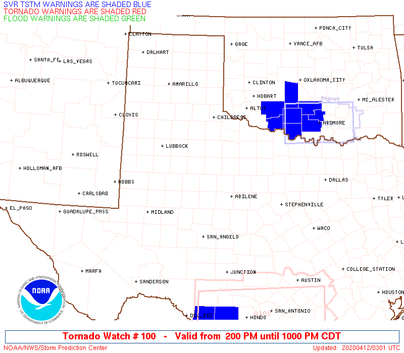
STATUS REPORT #7 ON WW 100
VALID 120230Z - 120300Z
SEVERE WEATHER THREAT CONTINUES RIGHT OF A LINE FROM 50 NNE 6R6
TO 40 W SJT TO 60 WNW ABI TO 45 SSE CDS TO 30 SSE LTS TO 5 WSW
FSI TO 20 W CHK.
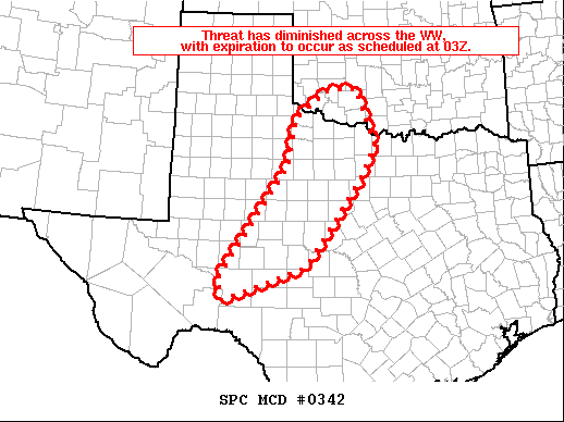
WW 100 WILL BE ALLOWED TO EXPIRE AT 120300Z.
FOR ADDITIONAL INFORMATION SEE MESOSCALE DISCUSSION 342
..COOK..04/12/20
ATTN...WFO...OUN...MAF...LUB...SJT...AMA...
&&
STATUS REPORT FOR WT 100
SEVERE WEATHER THREAT CONTINUES FOR THE FOLLOWING AREAS
OKC031-033-141-120300-
OK
. OKLAHOMA COUNTIES INCLUDED ARE
COMANCHE COTTON TILLMAN
$$
TXC009-023-059-077-081-105-151-155-207-235-253-275-353-399-413-
417-431-441-447-451-485-487-120300-
TX
. TEXAS COUNTIES INCLUDED ARE
ARCHER BAYLOR CALLAHAN
CLAY COKE CROCKETT
FISHER FOARD HASKELL
IRION JONES KNOX
NOLAN RUNNELS SCHLEICHER
SHACKELFORD STERLING TAYLOR
THROCKMORTON TOM GREEN WICHITA
WILBARGER
$$
THE WATCH STATUS MESSAGE IS FOR GUIDANCE PURPOSES ONLY. PLEASE
REFER TO WATCH COUNTY NOTIFICATION STATEMENTS FOR OFFICIAL
INFORMATION ON COUNTIES...INDEPENDENT CITIES AND MARINE ZONES
CLEARED FROM SEVERE THUNDERSTORM AND TORNADO WATCHES.
$$
STATUS REPORT #6 ON WW 100
VALID 120135Z - 120240Z
SEVERE WEATHER THREAT CONTINUES RIGHT OF A LINE FROM 50 NNE 6R6
TO 40 W SJT TO 60 WNW ABI TO 45 SSE CDS TO 30 W LTS TO 35 W CSM.
..COOK..04/12/20
ATTN...WFO...OUN...MAF...LUB...SJT...AMA...
&&
STATUS REPORT FOR WT 100
SEVERE WEATHER THREAT CONTINUES FOR THE FOLLOWING AREAS
OKC031-033-055-057-065-075-141-120240-
OK
. OKLAHOMA COUNTIES INCLUDED ARE
COMANCHE COTTON GREER
HARMON JACKSON KIOWA
TILLMAN
$$
TXC009-023-059-077-081-105-151-155-197-207-235-253-275-353-399-
413-417-431-441-447-451-485-487-120240-
TX
. TEXAS COUNTIES INCLUDED ARE
ARCHER BAYLOR CALLAHAN
CLAY COKE CROCKETT
FISHER FOARD HARDEMAN
HASKELL IRION JONES
KNOX NOLAN RUNNELS
SCHLEICHER SHACKELFORD STERLING
TAYLOR THROCKMORTON TOM GREEN
WICHITA WILBARGER
$$
THE WATCH STATUS MESSAGE IS FOR GUIDANCE PURPOSES ONLY. PLEASE
REFER TO WATCH COUNTY NOTIFICATION STATEMENTS FOR OFFICIAL
INFORMATION ON COUNTIES...INDEPENDENT CITIES AND MARINE ZONES
CLEARED FROM SEVERE THUNDERSTORM AND TORNADO WATCHES.
$$
STATUS REPORT #5 ON WW 100
VALID 120035Z - 120140Z
SEVERE WEATHER THREAT CONTINUES RIGHT OF A LINE FROM 15 ENE LBB
TO 15 W CDS TO 25 WSW CSM.
..COOK..04/12/20
ATTN...WFO...OUN...MAF...LUB...SJT...AMA...
&&
STATUS REPORT FOR WT 100
SEVERE WEATHER THREAT CONTINUES FOR THE FOLLOWING AREAS
OKC031-033-055-057-065-075-141-120140-
OK
. OKLAHOMA COUNTIES INCLUDED ARE
COMANCHE COTTON GREER
HARMON JACKSON KIOWA
TILLMAN
$$
TXC009-023-033-059-075-077-081-101-105-107-125-151-153-155-169-
173-197-207-227-235-253-263-269-275-335-345-353-383-399-413-415-
417-431-433-441-447-451-485-487-120140-
TX
. TEXAS COUNTIES INCLUDED ARE
ARCHER BAYLOR BORDEN
CALLAHAN CHILDRESS CLAY
COKE COTTLE CROCKETT
CROSBY DICKENS FISHER
FLOYD FOARD GARZA
GLASSCOCK HARDEMAN HASKELL
HOWARD IRION JONES
KENT KING KNOX
MITCHELL MOTLEY NOLAN
REAGAN RUNNELS SCHLEICHER
SCURRY SHACKELFORD STERLING
STONEWALL TAYLOR THROCKMORTON
TOM GREEN WICHITA WILBARGER
$$
THE WATCH STATUS MESSAGE IS FOR GUIDANCE PURPOSES ONLY. PLEASE
REFER TO WATCH COUNTY NOTIFICATION STATEMENTS FOR OFFICIAL
INFORMATION ON COUNTIES...INDEPENDENT CITIES AND MARINE ZONES
CLEARED FROM SEVERE THUNDERSTORM AND TORNADO WATCHES.
$$
STATUS REPORT #4 ON WW 100
VALID 112335Z - 120040Z
SEVERE WEATHER THREAT CONTINUES RIGHT OF A LINE FROM 15 NNE LBB
TO 35 ENE PVW TO 55 WNW CSM.
FOR ADDITIONAL INFORMATION SEE MESOSCALE DISCUSSION 338
..COOK..04/11/20
ATTN...WFO...OUN...MAF...LUB...SJT...AMA...
&&
STATUS REPORT FOR WT 100
SEVERE WEATHER THREAT CONTINUES FOR THE FOLLOWING AREAS
OKC031-033-055-057-065-075-141-120040-
OK
. OKLAHOMA COUNTIES INCLUDED ARE
COMANCHE COTTON GREER
HARMON JACKSON KIOWA
TILLMAN
$$
TXC009-023-033-059-075-077-081-087-101-105-107-125-151-153-155-
169-173-191-197-207-227-235-253-263-269-275-335-345-353-383-399-
413-415-417-431-433-441-447-451-485-487-120040-
TX
. TEXAS COUNTIES INCLUDED ARE
ARCHER BAYLOR BORDEN
CALLAHAN CHILDRESS CLAY
COKE COLLINGSWORTH COTTLE
CROCKETT CROSBY DICKENS
FISHER FLOYD FOARD
GARZA GLASSCOCK HALL
HARDEMAN HASKELL HOWARD
IRION JONES KENT
KING KNOX MITCHELL
MOTLEY NOLAN REAGAN
RUNNELS SCHLEICHER SCURRY
SHACKELFORD STERLING STONEWALL
TAYLOR THROCKMORTON TOM GREEN
WICHITA WILBARGER
$$
THE WATCH STATUS MESSAGE IS FOR GUIDANCE PURPOSES ONLY. PLEASE
REFER TO WATCH COUNTY NOTIFICATION STATEMENTS FOR OFFICIAL
INFORMATION ON COUNTIES...INDEPENDENT CITIES AND MARINE ZONES
CLEARED FROM SEVERE THUNDERSTORM AND TORNADO WATCHES.
$$
STATUS REPORT #3 ON WW 100
VALID 112240Z - 112340Z
THE SEVERE WEATHER THREAT CONTINUES ACROSS THE ENTIRE WATCH AREA.
..COOK..04/11/20
ATTN...WFO...OUN...MAF...LUB...SJT...AMA...
&&
STATUS REPORT FOR WT 100
SEVERE WEATHER THREAT CONTINUES FOR THE FOLLOWING AREAS
OKC031-033-055-057-065-075-141-112340-
OK
. OKLAHOMA COUNTIES INCLUDED ARE
COMANCHE COTTON GREER
HARMON JACKSON KIOWA
TILLMAN
$$
TXC009-023-033-045-059-075-077-081-087-101-105-107-125-129-151-
153-155-169-173-191-197-207-227-235-253-263-269-275-335-345-353-
383-399-413-415-417-431-433-441-447-451-485-487-112340-
TX
. TEXAS COUNTIES INCLUDED ARE
ARCHER BAYLOR BORDEN
BRISCOE CALLAHAN CHILDRESS
CLAY COKE COLLINGSWORTH
COTTLE CROCKETT CROSBY
DICKENS DONLEY FISHER
FLOYD FOARD GARZA
GLASSCOCK HALL HARDEMAN
HASKELL HOWARD IRION
JONES KENT KING
KNOX MITCHELL MOTLEY
NOLAN REAGAN RUNNELS
SCHLEICHER SCURRY SHACKELFORD
STERLING STONEWALL TAYLOR
THROCKMORTON TOM GREEN WICHITA
WILBARGER
$$
THE WATCH STATUS MESSAGE IS FOR GUIDANCE PURPOSES ONLY. PLEASE
REFER TO WATCH COUNTY NOTIFICATION STATEMENTS FOR OFFICIAL
INFORMATION ON COUNTIES...INDEPENDENT CITIES AND MARINE ZONES
CLEARED FROM SEVERE THUNDERSTORM AND TORNADO WATCHES.
$$
STATUS REPORT #2 ON WW 100
VALID 112155Z - 112240Z
THE SEVERE WEATHER THREAT CONTINUES ACROSS THE ENTIRE WATCH AREA.
..COOK..04/11/20
ATTN...WFO...OUN...MAF...LUB...SJT...AMA...
&&
STATUS REPORT FOR WT 100
SEVERE WEATHER THREAT CONTINUES FOR THE FOLLOWING AREAS
OKC031-033-055-057-065-075-141-112240-
OK
. OKLAHOMA COUNTIES INCLUDED ARE
COMANCHE COTTON GREER
HARMON JACKSON KIOWA
TILLMAN
$$
TXC009-023-033-045-059-075-077-081-087-101-105-107-125-129-151-
153-155-169-173-191-197-207-227-235-253-263-269-275-335-345-353-
383-399-413-415-417-431-433-441-447-451-485-487-112240-
TX
. TEXAS COUNTIES INCLUDED ARE
ARCHER BAYLOR BORDEN
BRISCOE CALLAHAN CHILDRESS
CLAY COKE COLLINGSWORTH
COTTLE CROCKETT CROSBY
DICKENS DONLEY FISHER
FLOYD FOARD GARZA
GLASSCOCK HALL HARDEMAN
HASKELL HOWARD IRION
JONES KENT KING
KNOX MITCHELL MOTLEY
NOLAN REAGAN RUNNELS
SCHLEICHER SCURRY SHACKELFORD
STERLING STONEWALL TAYLOR
THROCKMORTON TOM GREEN WICHITA
WILBARGER
$$
THE WATCH STATUS MESSAGE IS FOR GUIDANCE PURPOSES ONLY. PLEASE
REFER TO WATCH COUNTY NOTIFICATION STATEMENTS FOR OFFICIAL
INFORMATION ON COUNTIES...INDEPENDENT CITIES AND MARINE ZONES
CLEARED FROM SEVERE THUNDERSTORM AND TORNADO WATCHES.
$$
STATUS REPORT #1 ON WW 100
VALID 112040Z - 112140Z
THE SEVERE WEATHER THREAT CONTINUES ACROSS THE ENTIRE WATCH AREA.
FOR ADDITIONAL INFORMATION SEE MESOSCALE DISCUSSION 335
..ELLIOTT..04/11/20
ATTN...WFO...OUN...MAF...LUB...SJT...AMA...
&&
STATUS REPORT FOR WT 100
SEVERE WEATHER THREAT CONTINUES FOR THE FOLLOWING AREAS
OKC031-033-055-057-065-075-141-112140-
OK
. OKLAHOMA COUNTIES INCLUDED ARE
COMANCHE COTTON GREER
HARMON JACKSON KIOWA
TILLMAN
$$
TXC009-023-033-045-059-075-077-081-087-101-105-107-125-129-151-
153-155-169-173-191-197-207-227-235-253-263-269-275-335-345-353-
383-399-413-415-417-431-433-441-447-451-485-487-112140-
TX
. TEXAS COUNTIES INCLUDED ARE
ARCHER BAYLOR BORDEN
BRISCOE CALLAHAN CHILDRESS
CLAY COKE COLLINGSWORTH
COTTLE CROCKETT CROSBY
DICKENS DONLEY FISHER
FLOYD FOARD GARZA
GLASSCOCK HALL HARDEMAN
HASKELL HOWARD IRION
JONES KENT KING
KNOX MITCHELL MOTLEY
NOLAN REAGAN RUNNELS
SCHLEICHER SCURRY SHACKELFORD
STERLING STONEWALL TAYLOR
THROCKMORTON TOM GREEN WICHITA
WILBARGER
$$
THE WATCH STATUS MESSAGE IS FOR GUIDANCE PURPOSES ONLY. PLEASE
REFER TO WATCH COUNTY NOTIFICATION STATEMENTS FOR OFFICIAL
INFORMATION ON COUNTIES...INDEPENDENT CITIES AND MARINE ZONES
CLEARED FROM SEVERE THUNDERSTORM AND TORNADO WATCHES.
$$
Note:
Click for Complete Product Text.
Tornadoes
Probability of 2 or more tornadoes
|
Mod (60%)
|
Probability of 1 or more strong (EF2-EF5) tornadoes
|
Low (20%)
|
Wind
Probability of 10 or more severe wind events
|
Mod (40%)
|
Probability of 1 or more wind events > 65 knots
|
Low (20%)
|
Hail
Probability of 10 or more severe hail events
|
High (70%)
|
Probability of 1 or more hailstones > 2 inches
|
Mod (60%)
|
Combined Severe Hail/Wind
Probability of 6 or more combined severe hail/wind events
|
High (90%)
|
For each watch, probabilities for particular events inside the watch
(listed above in each table) are determined by the issuing forecaster.
The "Low" category contains probability values ranging from less than 2%
to 20% (EF2-EF5 tornadoes), less than 5% to 20% (all other probabilities),
"Moderate" from 30% to 60%, and "High" from 70% to greater than 95%.
High values are bolded and lighter in color to provide awareness of
an increased threat for a particular event.


 @NWSSPC