 Note:
The expiration time in the watch graphic is amended if the watch is
replaced, cancelled or extended.
Note:
Note:
The expiration time in the watch graphic is amended if the watch is
replaced, cancelled or extended.
Note: Click for
Watch Status Reports.
SEL1
URGENT - IMMEDIATE BROADCAST REQUESTED
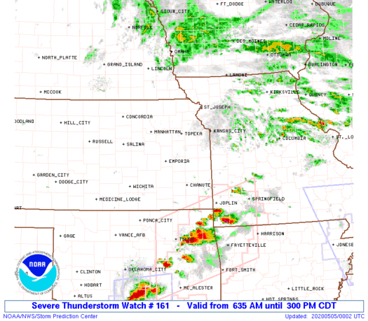
Severe Thunderstorm Watch Number 161
NWS Storm Prediction Center Norman OK
635 AM CDT Mon May 4 2020
The NWS Storm Prediction Center has issued a
* Severe Thunderstorm Watch for portions of
Northern, central and eastern Kansas
Western and southern Missouri
* Effective this Monday morning and afternoon from 635 AM until
300 PM CDT.
* Primary threats include...
Scattered large hail likely with isolated very large hail events
to 3 inches in diameter possible
Scattered damaging winds and isolated significant gusts to 75
mph possible
SUMMARY...Strong thunderstorms are developing in parts of central
Kansas, and should increase greatly in both coverage and intensity
across the rest of the Kansas part of the watch in the next few
hours, before shifting eastward into Missouri. Large hail is the
main threat, though severe gusts are an increasing concern with time
through the morning.
The severe thunderstorm watch area is approximately along and 145
statute miles east and west of a line from 45 miles northeast of
Concordia KS to 25 miles south of Springfield MO. For a complete
depiction of the watch see the associated watch outline update
(WOUS64 KWNS WOU1).
PRECAUTIONARY/PREPAREDNESS ACTIONS...
REMEMBER...A Severe Thunderstorm Watch means conditions are
favorable for severe thunderstorms in and close to the watch area.
Persons in these areas should be on the lookout for threatening
weather conditions and listen for later statements and possible
warnings. Severe thunderstorms can and occasionally do produce
tornadoes.
&&
AVIATION...A few severe thunderstorms with hail surface and aloft to
3 inches. Extreme turbulence and surface wind gusts to 65 knots. A
few cumulonimbi with maximum tops to 600. Mean storm motion vector
29035.
...Edwards
   SEL1

   URGENT - IMMEDIATE BROADCAST REQUESTED
   Severe Thunderstorm Watch Number 161
   NWS Storm Prediction Center Norman OK
   635 AM CDT Mon May 4 2020

   The NWS Storm Prediction Center has issued a

   * Severe Thunderstorm Watch for portions of
     Northern, central and eastern Kansas
     Western and southern Missouri

   * Effective this Monday morning and afternoon from 635 AM until
     300 PM CDT.

   * Primary threats include...
     Scattered large hail likely with isolated very large hail events
       to 3 inches in diameter possible
     Scattered damaging winds and isolated significant gusts to 75
       mph possible

   SUMMARY...Strong thunderstorms are developing in parts of central
   Kansas, and should increase greatly in both coverage and intensity
   across the rest of the Kansas part of the watch in the next few
   hours, before shifting eastward into Missouri.  Large hail is the
   main threat, though severe gusts are an increasing concern with time
   through the morning.

   The severe thunderstorm watch area is approximately along and 145
   statute miles east and west of a line from 45 miles northeast of
   Concordia KS to 25 miles south of Springfield MO. For a complete
   depiction of the watch see the associated watch outline update
   (WOUS64 KWNS WOU1).

   PRECAUTIONARY/PREPAREDNESS ACTIONS...

   REMEMBER...A Severe Thunderstorm Watch means conditions are
   favorable for severe thunderstorms in and close to the watch area.
   Persons in these areas should be on the lookout for threatening
   weather conditions and listen for later statements and possible
   warnings. Severe thunderstorms can and occasionally do produce
   tornadoes.

   &&

   AVIATION...A few severe thunderstorms with hail surface and aloft to
   3 inches. Extreme turbulence and surface wind gusts to 65 knots. A
   few cumulonimbi with maximum tops to 600. Mean storm motion vector
   29035.

   ...Edwards
 Note:
The Aviation Watch (SAW) product is an approximation to the watch area.
The actual watch is depicted by the shaded areas.
Note:
The Aviation Watch (SAW) product is an approximation to the watch area.
The actual watch is depicted by the shaded areas.
SAW1
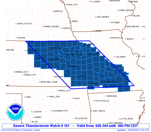
WW 161 SEVERE TSTM KS MO 041135Z - 042000Z
AXIS..145 STATUTE MILES EAST AND WEST OF LINE..
45NE CNK/CONCORDIA KS/ - 25S SGF/SPRINGFIELD MO/
..AVIATION COORDS.. 125NM E/W /40WSW PWE - 30S SGF/
HAIL SURFACE AND ALOFT..3 INCHES. WIND GUSTS..65 KNOTS.
MAX TOPS TO 600. MEAN STORM MOTION VECTOR 29035.
LAT...LON 39979431 36839076 36839600 39979979
THIS IS AN APPROXIMATION TO THE WATCH AREA. FOR A
COMPLETE DEPICTION OF THE WATCH SEE WOUS64 KWNS
FOR WOU1.
Watch 161 Status Report Messages:
STATUS REPORT #8 ON WW 161

VALID 041945Z - 042040Z

SEVERE WEATHER THREAT CONTINUES RIGHT OF A LINE FROM 25 NW FLP TO
20 ENE SGF TO 30 WSW TBN TO 15 NNW TBN TO 20 SSE JEF.

..GLEASON..05/04/20

ATTN...WFO...ICT...TOP...EAX...SGF...GID...

&&

STATUS REPORT FOR WS 161

SEVERE WEATHER THREAT CONTINUES FOR THE FOLLOWING AREAS

MOC065-067-091-105-125-149-153-161-169-203-215-225-229-042040-

MO
.    MISSOURI COUNTIES INCLUDED ARE

DENT		     DOUGLAS		 HOWELL
LACLEDE 	     MARIES		 OREGON
OZARK		     PHELPS		 PULASKI
SHANNON 	     TEXAS		 WEBSTER
WRIGHT
$$


THE WATCH STATUS MESSAGE IS FOR GUIDANCE PURPOSES ONLY.  PLEASE
REFER TO WATCH COUNTY NOTIFICATION STATEMENTS FOR OFFICIAL
INFORMATION ON COUNTIES...INDEPENDENT CITIES AND MARINE ZONES
CLEARED FROM SEVERE THUNDERSTORM AND TORNADO WATCHES.
$$

STATUS REPORT #7 ON WW 161

VALID 041845Z - 041940Z

SEVERE WEATHER THREAT CONTINUES RIGHT OF A LINE FROM 20 NE HRO TO
35 NE JLN TO 55 NNE SGF TO 40 NE SZL.

FOR ADDITIONAL INFORMATION SEE MESOSCALE DISCUSSION 531

..GLEASON..05/04/20

ATTN...WFO...ICT...TOP...EAX...SGF...GID...

&&

STATUS REPORT FOR WS 161

SEVERE WEATHER THREAT CONTINUES FOR THE FOLLOWING AREAS

MOC029-043-057-059-065-067-077-085-091-105-125-131-141-149-153-
161-167-169-203-213-215-225-229-041940-

MO
.    MISSOURI COUNTIES INCLUDED ARE

CAMDEN		     CHRISTIAN		 DADE
DALLAS		     DENT		 DOUGLAS
GREENE		     HICKORY		 HOWELL
LACLEDE 	     MARIES		 MILLER
MORGAN		     OREGON		 OZARK
PHELPS		     POLK		 PULASKI
SHANNON 	     TANEY		 TEXAS
WEBSTER 	     WRIGHT
$$


THE WATCH STATUS MESSAGE IS FOR GUIDANCE PURPOSES ONLY.  PLEASE
REFER TO WATCH COUNTY NOTIFICATION STATEMENTS FOR OFFICIAL
INFORMATION ON COUNTIES...INDEPENDENT CITIES AND MARINE ZONES
CLEARED FROM SEVERE THUNDERSTORM AND TORNADO WATCHES.
$$

STATUS REPORT #6 ON WW 161

VALID 041735Z - 041840Z

SEVERE WEATHER THREAT CONTINUES RIGHT OF A LINE FROM 20 NNW HRO
TO 30 ENE CNU TO 45 SSE OJC TO 30 W SZL TO 30 E MKC TO 40 NNE SZL.

..GLEASON..05/04/20

ATTN...WFO...ICT...TOP...EAX...SGF...GID...

&&

STATUS REPORT FOR WS 161

SEVERE WEATHER THREAT CONTINUES FOR THE FOLLOWING AREAS

KSC011-041840-

KS
.    KANSAS COUNTIES INCLUDED ARE

BOURBON
$$


MOC011-013-015-029-037-039-043-057-059-065-067-077-083-085-091-
101-105-107-109-125-131-141-149-153-159-161-167-169-185-203-209-
213-215-217-225-229-041840-

MO
.    MISSOURI COUNTIES INCLUDED ARE

BARTON		     BATES		 BENTON
CAMDEN		     CASS		 CEDAR
CHRISTIAN	     DADE		 DALLAS
DENT		     DOUGLAS		 GREENE
HENRY		     HICKORY		 HOWELL
JOHNSON 	     LACLEDE		 LAFAYETTE
LAWRENCE	     MARIES		 MILLER
MORGAN		     OREGON		 OZARK
PETTIS		     PHELPS		 POLK
PULASKI 	     ST. CLAIR		 SHANNON
STONE		     TANEY		 TEXAS
VERNON		     WEBSTER		 WRIGHT
$$


THE WATCH STATUS MESSAGE IS FOR GUIDANCE PURPOSES ONLY.  PLEASE
REFER TO WATCH COUNTY NOTIFICATION STATEMENTS FOR OFFICIAL
INFORMATION ON COUNTIES...INDEPENDENT CITIES AND MARINE ZONES
CLEARED FROM SEVERE THUNDERSTORM AND TORNADO WATCHES.
$$

STATUS REPORT #5 ON WW 161

VALID 041645Z - 041740Z

SEVERE WEATHER THREAT CONTINUES RIGHT OF A LINE FROM 40 NW BVO TO
25 N CNU TO 35 SSW OJC TO 15 WNW OJC TO 40 NNE SZL.

FOR ADDITIONAL INFORMATION SEE MESOSCALE DISCUSSION 529

..GLEASON..05/04/20

ATTN...WFO...ICT...TOP...EAX...SGF...GID...

&&

STATUS REPORT FOR WS 161

SEVERE WEATHER THREAT CONTINUES FOR THE FOLLOWING AREAS

KSC001-003-011-021-037-091-099-107-121-125-133-205-207-041740-

KS
.    KANSAS COUNTIES INCLUDED ARE

ALLEN		     ANDERSON		 BOURBON
CHEROKEE	     CRAWFORD		 JOHNSON
LABETTE 	     LINN		 MIAMI
MONTGOMERY	     NEOSHO		 WILSON
WOODSON
$$


MOC009-011-013-015-029-037-039-043-057-059-065-067-077-083-085-
091-095-097-101-105-107-109-119-125-131-141-145-149-153-159-161-
167-169-185-203-209-213-215-217-225-229-041740-

MO
.    MISSOURI COUNTIES INCLUDED ARE

BARRY		     BARTON		 BATES
BENTON		     CAMDEN		 CASS
CEDAR		     CHRISTIAN		 DADE
DALLAS		     DENT		 DOUGLAS
GREENE		     HENRY		 HICKORY
HOWELL		     JACKSON		 JASPER
JOHNSON 	     LACLEDE		 LAFAYETTE
LAWRENCE	     MCDONALD		 MARIES
MILLER		     MORGAN		 NEWTON
OREGON		     OZARK		 PETTIS
PHELPS		     POLK		 PULASKI
ST. CLAIR	     SHANNON		 STONE
TANEY		     TEXAS		 VERNON
WEBSTER 	     WRIGHT
$$


THE WATCH STATUS MESSAGE IS FOR GUIDANCE PURPOSES ONLY.  PLEASE
REFER TO WATCH COUNTY NOTIFICATION STATEMENTS FOR OFFICIAL
INFORMATION ON COUNTIES...INDEPENDENT CITIES AND MARINE ZONES
CLEARED FROM SEVERE THUNDERSTORM AND TORNADO WATCHES.
$$

STATUS REPORT #4 ON WW 161

VALID 041600Z - 041740Z

SEVERE WEATHER THREAT CONTINUES RIGHT OF A LINE FROM 25 ESE ICT
TO 25 SSW TOP TO 20 NNE TOP TO 30 SSE CDJ.

FOR ADDITIONAL INFORMATION SEE MESOSCALE DISCUSSION 529

..GLEASON..05/04/20

ATTN...WFO...ICT...TOP...EAX...SGF...GID...

&&

STATUS REPORT FOR WS 161

SEVERE WEATHER THREAT CONTINUES FOR THE FOLLOWING AREAS

KSC001-003-011-021-031-037-045-059-073-087-091-099-103-107-111-
121-125-133-139-177-205-207-209-041740-

KS
.    KANSAS COUNTIES INCLUDED ARE

ALLEN		     ANDERSON		 BOURBON
CHEROKEE	     COFFEY		 CRAWFORD
DOUGLAS 	     FRANKLIN		 GREENWOOD
JEFFERSON	     JOHNSON		 LABETTE
LEAVENWORTH	     LINN		 LYON
MIAMI		     MONTGOMERY 	 NEOSHO
OSAGE		     SHAWNEE		 WILSON
WOODSON 	     WYANDOTTE
$$


MOC009-011-013-015-029-037-039-043-047-057-059-065-067-077-083-
085-091-095-097-101-105-107-109-119-125-131-141-145-149-153-159-
161-165-167-169-177-185-203-209-213-215-217-225-229-041740-

MO
.    MISSOURI COUNTIES INCLUDED ARE

BARRY		     BARTON		 BATES
BENTON		     CAMDEN		 CASS
CEDAR		     CHRISTIAN		 CLAY
DADE		     DALLAS		 DENT
DOUGLAS 	     GREENE		 HENRY
HICKORY 	     HOWELL		 JACKSON
JASPER		     JOHNSON		 LACLEDE
LAFAYETTE	     LAWRENCE		 MCDONALD
MARIES		     MILLER		 MORGAN
NEWTON		     OREGON		 OZARK
PETTIS		     PHELPS		 PLATTE
POLK		     PULASKI		 RAY
ST. CLAIR	     SHANNON		 STONE
TANEY		     TEXAS		 VERNON
WEBSTER 	     WRIGHT
$$


THE WATCH STATUS MESSAGE IS FOR GUIDANCE PURPOSES ONLY.  PLEASE
REFER TO WATCH COUNTY NOTIFICATION STATEMENTS FOR OFFICIAL
INFORMATION ON COUNTIES...INDEPENDENT CITIES AND MARINE ZONES
CLEARED FROM SEVERE THUNDERSTORM AND TORNADO WATCHES.
$$

STATUS REPORT #3 ON WW 161

VALID 041445Z - 041540Z

SEVERE WEATHER THREAT CONTINUES RIGHT OF A LINE FROM 45 SSW RSL
TO 25 NE SLN TO 35 WSW BIE.

FOR ADDITIONAL INFORMATION SEE MESOSCALE DISCUSSION 528

..GLEASON..05/04/20

ATTN...WFO...ICT...TOP...EAX...SGF...GID...

&&

STATUS REPORT FOR WS 161

SEVERE WEATHER THREAT CONTINUES FOR THE FOLLOWING AREAS

KSC001-003-005-009-011-013-017-021-027-031-037-041-043-045-053-
059-061-073-085-087-091-099-103-107-111-113-115-117-121-125-127-
131-133-139-149-159-161-169-177-197-201-205-207-209-041540-

KS
.    KANSAS COUNTIES INCLUDED ARE

ALLEN		     ANDERSON		 ATCHISON
BARTON		     BOURBON		 BROWN
CHASE		     CHEROKEE		 CLAY
COFFEY		     CRAWFORD		 DICKINSON
DONIPHAN	     DOUGLAS		 ELLSWORTH
FRANKLIN	     GEARY		 GREENWOOD
JACKSON 	     JEFFERSON		 JOHNSON
LABETTE 	     LEAVENWORTH	 LINN
LYON		     MCPHERSON		 MARION
MARSHALL	     MIAMI		 MONTGOMERY
MORRIS		     NEMAHA		 NEOSHO
OSAGE		     POTTAWATOMIE	 RICE
RILEY		     SALINE		 SHAWNEE
WABAUNSEE	     WASHINGTON 	 WILSON
WOODSON 	     WYANDOTTE
$$


MOC009-011-013-015-021-029-037-039-043-047-049-057-059-065-067-
077-083-085-091-095-097-101-105-107-109-119-125-131-141-145-149-
153-159-161-165-167-169-177-185-203-209-213-215-217-225-229-
041540-

MO
.    MISSOURI COUNTIES INCLUDED ARE

BARRY		     BARTON		 BATES
BENTON		     BUCHANAN		 CAMDEN
CASS		     CEDAR		 CHRISTIAN
CLAY		     CLINTON		 DADE
DALLAS		     DENT		 DOUGLAS
GREENE		     HENRY		 HICKORY
HOWELL		     JACKSON		 JASPER
JOHNSON 	     LACLEDE		 LAFAYETTE
LAWRENCE	     MCDONALD		 MARIES
MILLER		     MORGAN		 NEWTON
OREGON		     OZARK		 PETTIS
PHELPS		     PLATTE		 POLK
PULASKI 	     RAY		 ST. CLAIR
SHANNON 	     STONE		 TANEY
TEXAS		     VERNON		 WEBSTER
WRIGHT
$$


THE WATCH STATUS MESSAGE IS FOR GUIDANCE PURPOSES ONLY.  PLEASE
REFER TO WATCH COUNTY NOTIFICATION STATEMENTS FOR OFFICIAL
INFORMATION ON COUNTIES...INDEPENDENT CITIES AND MARINE ZONES
CLEARED FROM SEVERE THUNDERSTORM AND TORNADO WATCHES.
$$

STATUS REPORT #2 ON WW 161

VALID 041340Z - 041440Z

SEVERE WEATHER THREAT CONTINUES RIGHT OF A LINE FROM 30 WNW RSL
TO 30 NNE RSL TO 35 SSE HSI.

..GLEASON..05/04/20

ATTN...WFO...ICT...TOP...EAX...SGF...GID...

&&

STATUS REPORT FOR WS 161

SEVERE WEATHER THREAT CONTINUES FOR THE FOLLOWING AREAS

KSC001-003-005-009-011-013-017-021-027-029-031-037-041-043-045-
053-059-061-073-085-087-089-091-099-103-105-107-111-113-115-117-
121-123-125-127-131-133-139-143-149-157-159-161-167-169-177-197-
201-205-207-209-041440-

KS
.    KANSAS COUNTIES INCLUDED ARE

ALLEN		     ANDERSON		 ATCHISON
BARTON		     BOURBON		 BROWN
CHASE		     CHEROKEE		 CLAY
CLOUD		     COFFEY		 CRAWFORD
DICKINSON	     DONIPHAN		 DOUGLAS
ELLSWORTH	     FRANKLIN		 GEARY
GREENWOOD	     JACKSON		 JEFFERSON
JEWELL		     JOHNSON		 LABETTE
LEAVENWORTH	     LINCOLN		 LINN
LYON		     MCPHERSON		 MARION
MARSHALL	     MIAMI		 MITCHELL
MONTGOMERY	     MORRIS		 NEMAHA
NEOSHO		     OSAGE		 OTTAWA
POTTAWATOMIE	     REPUBLIC		 RICE
RILEY		     RUSSELL		 SALINE
SHAWNEE 	     WABAUNSEE		 WASHINGTON
WILSON		     WOODSON		 WYANDOTTE
$$


MOC011-013-015-021-029-037-039-043-047-049-057-059-065-067-077-
083-085-091-095-097-101-105-107-109-125-131-141-145-149-159-161-
165-167-169-177-185-203-215-217-225-229-041440-

MO
.    MISSOURI COUNTIES INCLUDED ARE

BARTON		     BATES		 BENTON
BUCHANAN	     CAMDEN		 CASS
CEDAR		     CHRISTIAN		 CLAY
CLINTON 	     DADE		 DALLAS
DENT		     DOUGLAS		 GREENE
HENRY		     HICKORY		 HOWELL
JACKSON 	     JASPER		 JOHNSON
LACLEDE 	     LAFAYETTE		 LAWRENCE
MARIES		     MILLER		 MORGAN
NEWTON		     OREGON		 PETTIS
PHELPS		     PLATTE		 POLK
PULASKI 	     RAY		 ST. CLAIR
SHANNON 	     TEXAS		 VERNON
WEBSTER 	     WRIGHT
$$


THE WATCH STATUS MESSAGE IS FOR GUIDANCE PURPOSES ONLY.  PLEASE
REFER TO WATCH COUNTY NOTIFICATION STATEMENTS FOR OFFICIAL
INFORMATION ON COUNTIES...INDEPENDENT CITIES AND MARINE ZONES
CLEARED FROM SEVERE THUNDERSTORM AND TORNADO WATCHES.
$$

STATUS REPORT #1 ON WW 161

VALID 041220Z - 041340Z

THE SEVERE WEATHER THREAT CONTINUES ACROSS THE ENTIRE WATCH AREA.

..BROYLES..05/04/20

ATTN...WFO...ICT...TOP...EAX...SGF...GID...

&&

STATUS REPORT FOR WS 161

SEVERE WEATHER THREAT CONTINUES FOR THE FOLLOWING AREAS

KSC001-003-005-009-011-013-017-021-027-029-031-037-041-043-045-
053-059-061-073-085-087-089-091-099-103-105-107-111-113-115-117-
121-123-125-127-131-133-139-141-143-147-149-157-159-161-163-167-
169-177-183-197-201-205-207-209-041340-

KS
.    KANSAS COUNTIES INCLUDED ARE

ALLEN		     ANDERSON		 ATCHISON
BARTON		     BOURBON		 BROWN
CHASE		     CHEROKEE		 CLAY
CLOUD		     COFFEY		 CRAWFORD
DICKINSON	     DONIPHAN		 DOUGLAS
ELLSWORTH	     FRANKLIN		 GEARY
GREENWOOD	     JACKSON		 JEFFERSON
JEWELL		     JOHNSON		 LABETTE
LEAVENWORTH	     LINCOLN		 LINN
LYON		     MCPHERSON		 MARION
MARSHALL	     MIAMI		 MITCHELL
MONTGOMERY	     MORRIS		 NEMAHA
NEOSHO		     OSAGE		 OSBORNE
OTTAWA		     PHILLIPS		 POTTAWATOMIE
REPUBLIC	     RICE		 RILEY
ROOKS		     RUSSELL		 SALINE
SHAWNEE 	     SMITH		 WABAUNSEE
WASHINGTON	     WILSON		 WOODSON
WYANDOTTE
$$


MOC011-013-015-021-029-037-039-043-047-049-057-059-065-067-077-
083-085-091-095-097-101-105-107-109-125-131-141-145-149-159-161-
165-167-169-177-185-203-215-217-225-229-041340-

MO
.    MISSOURI COUNTIES INCLUDED ARE

BARTON		     BATES		 BENTON
BUCHANAN	     CAMDEN		 CASS
CEDAR		     CHRISTIAN		 CLAY
CLINTON 	     DADE		 DALLAS
DENT		     DOUGLAS		 GREENE
HENRY		     HICKORY		 HOWELL
JACKSON 	     JASPER		 JOHNSON
LACLEDE 	     LAFAYETTE		 LAWRENCE
MARIES		     MILLER		 MORGAN
NEWTON		     OREGON		 PETTIS
PHELPS		     PLATTE		 POLK
PULASKI 	     RAY		 ST. CLAIR
SHANNON 	     TEXAS		 VERNON
WEBSTER 	     WRIGHT
$$


THE WATCH STATUS MESSAGE IS FOR GUIDANCE PURPOSES ONLY.  PLEASE
REFER TO WATCH COUNTY NOTIFICATION STATEMENTS FOR OFFICIAL
INFORMATION ON COUNTIES...INDEPENDENT CITIES AND MARINE ZONES
CLEARED FROM SEVERE THUNDERSTORM AND TORNADO WATCHES.
$$
Note:
Click for Complete Product Text.
Tornadoes
Probability of 2 or more tornadoes
|
Low (10%)
|
Probability of 1 or more strong (EF2-EF5) tornadoes
|
Low (5%)
|
Wind
Probability of 10 or more severe wind events
|
Mod (50%)
|
Probability of 1 or more wind events > 65 knots
|
Mod (30%)
|
Hail
Probability of 10 or more severe hail events
|
High (70%)
|
Probability of 1 or more hailstones > 2 inches
|
Mod (50%)
|
Combined Severe Hail/Wind
Probability of 6 or more combined severe hail/wind events
|
High (>95%)
|
For each watch, probabilities for particular events inside the watch
(listed above in each table) are determined by the issuing forecaster.
The "Low" category contains probability values ranging from less than 2%
to 20% (EF2-EF5 tornadoes), less than 5% to 20% (all other probabilities),
"Moderate" from 30% to 60%, and "High" from 70% to greater than 95%.
High values are bolded and lighter in color to provide awareness of
an increased threat for a particular event.


 @NWSSPC


