 Note:
The expiration time in the watch graphic is amended if the watch is
replaced, cancelled or extended.
Note:
Note:
The expiration time in the watch graphic is amended if the watch is
replaced, cancelled or extended.
Note: Click for
Watch Status Reports.
SEL2
URGENT - IMMEDIATE BROADCAST REQUESTED
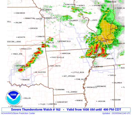
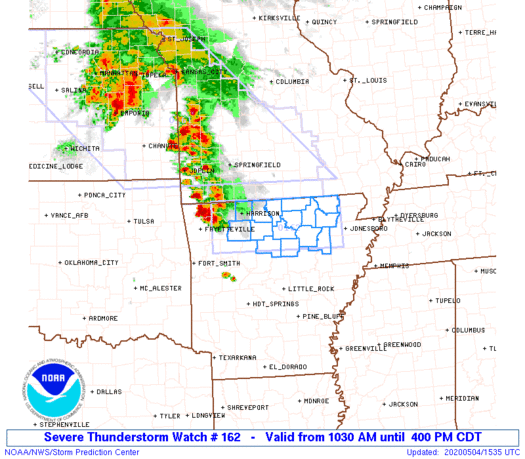
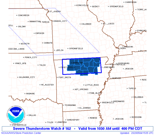
Severe Thunderstorm Watch Number 162
NWS Storm Prediction Center Norman OK
1030 AM CDT Mon May 4 2020
The NWS Storm Prediction Center has issued a
* Severe Thunderstorm Watch for portions of
Northern Arkansas
* Effective this Monday morning and afternoon from 1030 AM until
400 PM CDT.
* Primary threats include...
Scattered large hail likely with isolated very large hail events
to 2 inches in diameter possible
Scattered damaging wind gusts to 70 mph possible
A tornado or two possible
SUMMARY...Thunderstorms over northwest Arkansas will move eastward
through the day across the watch area. Large hail will be the main
threat with these storms, but an increasing risk of damaging winds
or even isolated tornadoes may develop this afternoon.
The severe thunderstorm watch area is approximately along and 35
statute miles north and south of a line from 45 miles west southwest
of Harrison AR to 15 miles southeast of Walnut Ridge AR. For a
complete depiction of the watch see the associated watch outline
update (WOUS64 KWNS WOU2).
PRECAUTIONARY/PREPAREDNESS ACTIONS...
REMEMBER...A Severe Thunderstorm Watch means conditions are
favorable for severe thunderstorms in and close to the watch area.
Persons in these areas should be on the lookout for threatening
weather conditions and listen for later statements and possible
warnings. Severe thunderstorms can and occasionally do produce
tornadoes.
&&
OTHER WATCH INFORMATION...CONTINUE...WW 161...
AVIATION...A few severe thunderstorms with hail surface and aloft to
2 inches. Extreme turbulence and surface wind gusts to 60 knots. A
few cumulonimbi with maximum tops to 500. Mean storm motion vector
27035.
...Hart
   SEL2

   URGENT - IMMEDIATE BROADCAST REQUESTED
   Severe Thunderstorm Watch Number 162
   NWS Storm Prediction Center Norman OK
   1030 AM CDT Mon May 4 2020

   The NWS Storm Prediction Center has issued a

   * Severe Thunderstorm Watch for portions of
     Northern Arkansas

   * Effective this Monday morning and afternoon from 1030 AM until
     400 PM CDT.

   * Primary threats include...
     Scattered large hail likely with isolated very large hail events
       to 2 inches in diameter possible
     Scattered damaging wind gusts to 70 mph possible
     A tornado or two possible

   SUMMARY...Thunderstorms over northwest Arkansas will move eastward
   through the day across the watch area.  Large hail will be the main
   threat with these storms, but an increasing risk of damaging winds
   or even isolated tornadoes may develop this afternoon.

   The severe thunderstorm watch area is approximately along and 35
   statute miles north and south of a line from 45 miles west southwest
   of Harrison AR to 15 miles southeast of Walnut Ridge AR. For a
   complete depiction of the watch see the associated watch outline
   update (WOUS64 KWNS WOU2).

   PRECAUTIONARY/PREPAREDNESS ACTIONS...

   REMEMBER...A Severe Thunderstorm Watch means conditions are
   favorable for severe thunderstorms in and close to the watch area.
   Persons in these areas should be on the lookout for threatening
   weather conditions and listen for later statements and possible
   warnings. Severe thunderstorms can and occasionally do produce
   tornadoes.

   &&

   OTHER WATCH INFORMATION...CONTINUE...WW 161...

   AVIATION...A few severe thunderstorms with hail surface and aloft to
   2 inches. Extreme turbulence and surface wind gusts to 60 knots. A
   few cumulonimbi with maximum tops to 500. Mean storm motion vector
   27035.

   ...Hart
 Note:
The Aviation Watch (SAW) product is an approximation to the watch area.
The actual watch is depicted by the shaded areas.
Note:
The Aviation Watch (SAW) product is an approximation to the watch area.
The actual watch is depicted by the shaded areas.
   SAW2
   WW 162 SEVERE TSTM AR 041530Z - 042100Z
   AXIS..35 STATUTE MILES NORTH AND SOUTH OF LINE..
   45WSW HRO/HARRISON AR/ - 15SE ARG/WALNUT RIDGE AR/
   ..AVIATION COORDS.. 30NM N/S /18SE RZC - 13SE ARG/
   HAIL SURFACE AND ALOFT..2 INCHES. WIND GUSTS..60 KNOTS.
   MAX TOPS TO 500. MEAN STORM MOTION VECTOR 27035.

   LAT...LON 36539389 36489074 35479074 35509389

   THIS IS AN APPROXIMATION TO THE WATCH AREA.  FOR A
   COMPLETE DEPICTION OF THE WATCH SEE WOUS64 KWNS
   FOR WOU2.
Watch 162 Status Report Messages:
STATUS REPORT #5 ON WW 162
VALID 042030Z - 042140Z
SEVERE WEATHER THREAT CONTINUES RIGHT OF A LINE FROM JBR TO 25
WSW UNO.
..GLEASON..05/04/20
ATTN...WFO...LZK...
&&
STATUS REPORT FOR WS 162
SEVERE WEATHER THREAT CONTINUES FOR THE FOLLOWING AREAS
ARC049-075-121-135-042140-
AR
. ARKANSAS COUNTIES INCLUDED ARE
FULTON LAWRENCE RANDOLPH
SHARP
$$
THE WATCH STATUS MESSAGE IS FOR GUIDANCE PURPOSES ONLY. PLEASE
REFER TO WATCH COUNTY NOTIFICATION STATEMENTS FOR OFFICIAL
INFORMATION ON COUNTIES...INDEPENDENT CITIES AND MARINE ZONES
CLEARED FROM SEVERE THUNDERSTORM AND TORNADO WATCHES.
$$
STATUS REPORT #4 ON WW 162
VALID 041945Z - 042040Z
SEVERE WEATHER THREAT CONTINUES RIGHT OF A LINE FROM 25 SSE BVX
TO 20 SW ARG TO 30 NNW FLP.
..GLEASON..05/04/20
ATTN...WFO...LZK...
&&
STATUS REPORT FOR WS 162
SEVERE WEATHER THREAT CONTINUES FOR THE FOLLOWING AREAS
ARC005-049-065-067-075-121-135-042040-
AR
. ARKANSAS COUNTIES INCLUDED ARE
BAXTER FULTON IZARD
JACKSON LAWRENCE RANDOLPH
SHARP
$$
THE WATCH STATUS MESSAGE IS FOR GUIDANCE PURPOSES ONLY. PLEASE
REFER TO WATCH COUNTY NOTIFICATION STATEMENTS FOR OFFICIAL
INFORMATION ON COUNTIES...INDEPENDENT CITIES AND MARINE ZONES
CLEARED FROM SEVERE THUNDERSTORM AND TORNADO WATCHES.
$$
STATUS REPORT #3 ON WW 162
VALID 041845Z - 041940Z
SEVERE WEATHER THREAT CONTINUES RIGHT OF A LINE FROM 30 ENE RUE
TO 15 SSE FLP TO 25 NNE HRO.
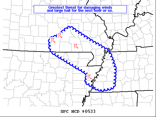
FOR ADDITIONAL INFORMATION SEE MESOSCALE DISCUSSION 531
..GLEASON..05/04/20
ATTN...WFO...LZK...
&&
STATUS REPORT FOR WS 162
SEVERE WEATHER THREAT CONTINUES FOR THE FOLLOWING AREAS
ARC005-023-049-063-065-067-075-089-121-135-137-141-041940-
AR
. ARKANSAS COUNTIES INCLUDED ARE
BAXTER CLEBURNE FULTON
INDEPENDENCE IZARD JACKSON
LAWRENCE MARION RANDOLPH
SHARP STONE VAN BUREN
$$
THE WATCH STATUS MESSAGE IS FOR GUIDANCE PURPOSES ONLY. PLEASE
REFER TO WATCH COUNTY NOTIFICATION STATEMENTS FOR OFFICIAL
INFORMATION ON COUNTIES...INDEPENDENT CITIES AND MARINE ZONES
CLEARED FROM SEVERE THUNDERSTORM AND TORNADO WATCHES.
$$
STATUS REPORT #2 ON WW 162
VALID 041740Z - 041840Z
SEVERE WEATHER THREAT CONTINUES RIGHT OF A LINE FROM 20 NNW RUE
TO 20 S HRO TO 15 ESE HRO TO 30 NNW FLP.
..GLEASON..05/04/20
ATTN...WFO...LZK...
&&
STATUS REPORT FOR WS 162
SEVERE WEATHER THREAT CONTINUES FOR THE FOLLOWING AREAS
ARC005-023-049-063-065-067-075-089-101-121-129-135-137-141-
041840-
AR
. ARKANSAS COUNTIES INCLUDED ARE
BAXTER CLEBURNE FULTON
INDEPENDENCE IZARD JACKSON
LAWRENCE MARION NEWTON
RANDOLPH SEARCY SHARP
STONE VAN BUREN
$$
THE WATCH STATUS MESSAGE IS FOR GUIDANCE PURPOSES ONLY. PLEASE
REFER TO WATCH COUNTY NOTIFICATION STATEMENTS FOR OFFICIAL
INFORMATION ON COUNTIES...INDEPENDENT CITIES AND MARINE ZONES
CLEARED FROM SEVERE THUNDERSTORM AND TORNADO WATCHES.
$$
STATUS REPORT #1 ON WW 162
VALID 041645Z - 041740Z
THE SEVERE WEATHER THREAT CONTINUES ACROSS THE ENTIRE WATCH AREA.
FOR ADDITIONAL INFORMATION SEE MESOSCALE DISCUSSION 529
..GLEASON..05/04/20
ATTN...WFO...LZK...
&&
STATUS REPORT FOR WS 162
SEVERE WEATHER THREAT CONTINUES FOR THE FOLLOWING AREAS
ARC005-009-023-049-063-065-067-075-089-101-121-129-135-137-141-
041740-
AR
. ARKANSAS COUNTIES INCLUDED ARE
BAXTER BOONE CLEBURNE
FULTON INDEPENDENCE IZARD
JACKSON LAWRENCE MARION
NEWTON RANDOLPH SEARCY
SHARP STONE VAN BUREN
$$
THE WATCH STATUS MESSAGE IS FOR GUIDANCE PURPOSES ONLY. PLEASE
REFER TO WATCH COUNTY NOTIFICATION STATEMENTS FOR OFFICIAL
INFORMATION ON COUNTIES...INDEPENDENT CITIES AND MARINE ZONES
CLEARED FROM SEVERE THUNDERSTORM AND TORNADO WATCHES.
$$
Note:
Click for Complete Product Text.
Tornadoes
Probability of 2 or more tornadoes
|
Low (20%)
|
Probability of 1 or more strong (EF2-EF5) tornadoes
|
Low (5%)
|
Wind
Probability of 10 or more severe wind events
|
Mod (40%)
|
Probability of 1 or more wind events > 65 knots
|
Low (20%)
|
Hail
Probability of 10 or more severe hail events
|
Mod (60%)
|
Probability of 1 or more hailstones > 2 inches
|
Mod (30%)
|
Combined Severe Hail/Wind
Probability of 6 or more combined severe hail/wind events
|
High (90%)
|
For each watch, probabilities for particular events inside the watch
(listed above in each table) are determined by the issuing forecaster.
The "Low" category contains probability values ranging from less than 2%
to 20% (EF2-EF5 tornadoes), less than 5% to 20% (all other probabilities),
"Moderate" from 30% to 60%, and "High" from 70% to greater than 95%.
High values are bolded and lighter in color to provide awareness of
an increased threat for a particular event.


 @NWSSPC