 Note:
The expiration time in the watch graphic is amended if the watch is
replaced, cancelled or extended.
Note:
Note:
The expiration time in the watch graphic is amended if the watch is
replaced, cancelled or extended.
Note: Click for
Watch Status Reports.
SEL7
URGENT - IMMEDIATE BROADCAST REQUESTED
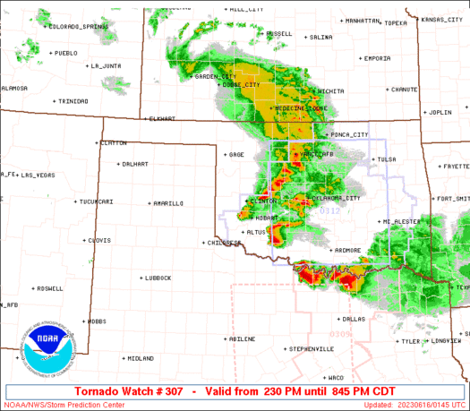
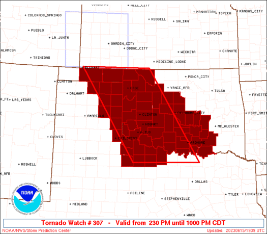
Tornado Watch Number 307
NWS Storm Prediction Center Norman OK
230 PM CDT Thu Jun 15 2023
The NWS Storm Prediction Center has issued a
* Tornado Watch for portions of
Western, southern and central Oklahoma and the eastern Oklahoma
Panhandle
The eastern Texas Panhandle and northwest Texas
* Effective this Thursday afternoon and evening from 230 PM until
1000 PM CDT.
* Primary threats include...
A few tornadoes likely
Widespread large hail and scattered very large hail events to 5
inches in diameter expected
Widespread damaging winds and isolated significant gusts to 90
mph likely
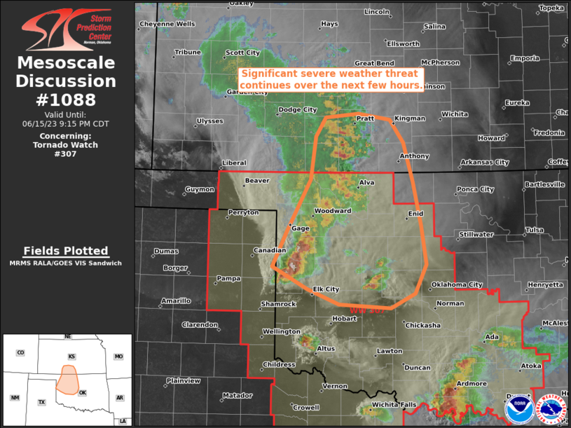
SUMMARY...Intense supercell development is expected this afternoon
from the eastern Texas Panhandle into western Oklahoma and northwest
Texas, and storms will spread eastward through late evening. The
initial, more discrete supercells will be capable of producing giant
hail (4-5 inches in diameter) and a few tornadoes. Upscale growth
into a cluster or two is possible this evening, with an increasing
threat for intense outflow winds of 80-90 mph.
The tornado watch area is approximately along and 85 statute miles
east and west of a line from 70 miles east northeast of Guymon OK to
40 miles southeast of Wichita Falls TX. For a complete depiction of
the watch see the associated watch outline update (WOUS64 KWNS
WOU7).
PRECAUTIONARY/PREPAREDNESS ACTIONS...
REMEMBER...A Tornado Watch means conditions are favorable for
tornadoes and severe thunderstorms in and close to the watch
area. Persons in these areas should be on the lookout for
threatening weather conditions and listen for later statements
and possible warnings.
&&
OTHER WATCH INFORMATION...CONTINUE...WW 302...WW 303...WW
304...WW 305...WW 306...
AVIATION...Tornadoes and a few severe thunderstorms with hail
surface and aloft to 5 inches. Extreme turbulence and surface wind
gusts to 80 knots. A few cumulonimbi with maximum tops to 650. Mean
storm motion vector 27025.
...Thompson
   SEL7

   URGENT - IMMEDIATE BROADCAST REQUESTED
   Tornado Watch Number 307
   NWS Storm Prediction Center Norman OK
   230 PM CDT Thu Jun 15 2023

   The NWS Storm Prediction Center has issued a

   * Tornado Watch for portions of
     Western, southern and central Oklahoma and the eastern Oklahoma
   Panhandle
     The eastern Texas Panhandle and northwest Texas

   * Effective this Thursday afternoon and evening from 230 PM until
     1000 PM CDT.

   * Primary threats include...
     A few tornadoes likely
     Widespread large hail and scattered very large hail events to 5
       inches in diameter expected
     Widespread damaging winds and isolated significant gusts to 90
       mph likely

   SUMMARY...Intense supercell development is expected this afternoon
   from the eastern Texas Panhandle into western Oklahoma and northwest
   Texas, and storms will spread eastward through late evening.  The
   initial, more discrete supercells will be capable of producing giant
   hail (4-5 inches in diameter) and a few tornadoes.  Upscale growth
   into a cluster or two is possible this evening, with an increasing
   threat for intense outflow winds of 80-90 mph.

   The tornado watch area is approximately along and 85 statute miles
   east and west of a line from 70 miles east northeast of Guymon OK to
   40 miles southeast of Wichita Falls TX. For a complete depiction of
   the watch see the associated watch outline update (WOUS64 KWNS
   WOU7).

   PRECAUTIONARY/PREPAREDNESS ACTIONS...

   REMEMBER...A Tornado Watch means conditions are favorable for
   tornadoes and severe thunderstorms in and close to the watch
   area. Persons in these areas should be on the lookout for
   threatening weather conditions and listen for later statements
   and possible warnings.

   &&

   OTHER WATCH INFORMATION...CONTINUE...WW 302...WW 303...WW
   304...WW 305...WW 306...

   AVIATION...Tornadoes and a few severe thunderstorms with hail
   surface and aloft to 5 inches. Extreme turbulence and surface wind
   gusts to 80 knots. A few cumulonimbi with maximum tops to 650. Mean
   storm motion vector 27025.

   ...Thompson
 Note:
The Aviation Watch (SAW) product is an approximation to the watch area.
The actual watch is depicted by the shaded areas.
Note:
The Aviation Watch (SAW) product is an approximation to the watch area.
The actual watch is depicted by the shaded areas.
   SAW7
   WW 307 TORNADO OK TX 151930Z - 160300Z
   AXIS..85 STATUTE MILES EAST AND WEST OF LINE..
   70ENE GUY/GUYMON OK/ - 40SE SPS/WICHITA FALLS TX/
   ..AVIATION COORDS.. 75NM E/W /31E LBL - 39SE SPS/
   HAIL SURFACE AND ALOFT..5 INCHES. WIND GUSTS..80 KNOTS.
   MAX TOPS TO 650. MEAN STORM MOTION VECTOR 27025.

   LAT...LON 37059879 33559653 33559948 37050187

   THIS IS AN APPROXIMATION TO THE WATCH AREA.  FOR A
   COMPLETE DEPICTION OF THE WATCH SEE WOUS64 KWNS
   FOR WOU7.
Watch 307 Status Report Messages:
STATUS REPORT #5 ON WW 307

VALID 160040Z - 160140Z

SEVERE WEATHER THREAT CONTINUES RIGHT OF A LINE FROM 55 NNW CDS
TO 50 W CSM TO 60 NNW CSM TO 25 SW P28.

..LYONS..06/16/23

ATTN...WFO...OUN...AMA...LUB...

&&

STATUS REPORT FOR WT 307

SEVERE WEATHER THREAT CONTINUES FOR THE FOLLOWING AREAS

OKC003-005-009-011-013-015-017-019-027-029-031-033-039-043-047-
049-051-055-057-063-065-067-069-073-075-083-085-087-093-095-099-
109-123-125-129-133-137-141-149-151-153-160140-

OK
.    OKLAHOMA COUNTIES INCLUDED ARE

ALFALFA 	     ATOKA		 BECKHAM
BLAINE		     BRYAN		 CADDO
CANADIAN	     CARTER		 CLEVELAND
COAL		     COMANCHE		 COTTON
CUSTER		     DEWEY		 GARFIELD
GARVIN		     GRADY		 GREER
HARMON		     HUGHES		 JACKSON
JEFFERSON	     JOHNSTON		 KINGFISHER
KIOWA		     LOGAN		 LOVE
MCCLAIN 	     MAJOR		 MARSHALL
MURRAY		     OKLAHOMA		 PONTOTOC
POTTAWATOMIE	     ROGER MILLS	 SEMINOLE
STEPHENS	     TILLMAN		 WASHITA
WOODS		     WOODWARD
$$


TXC009-023-075-077-087-155-197-275-485-487-160140-

TX
.    TEXAS COUNTIES INCLUDED ARE

ARCHER		     BAYLOR		 CHILDRESS
CLAY		     COLLINGSWORTH	 FOARD
HARDEMAN	     KNOX		 WICHITA
WILBARGER
$$


THE WATCH STATUS MESSAGE IS FOR GUIDANCE PURPOSES ONLY.  PLEASE
REFER TO WATCH COUNTY NOTIFICATION STATEMENTS FOR OFFICIAL
INFORMATION ON COUNTIES...INDEPENDENT CITIES AND MARINE ZONES
CLEARED FROM SEVERE THUNDERSTORM AND TORNADO WATCHES.
$$

STATUS REPORT #4 ON WW 307

VALID 152340Z - 160040Z

SEVERE WEATHER THREAT CONTINUES RIGHT OF A LINE FROM 50 ESE BGD
TO 60 SE LBL TO 45 S DDC.

..LYONS..06/15/23

ATTN...WFO...OUN...AMA...LUB...

&&

STATUS REPORT FOR WT 307

SEVERE WEATHER THREAT CONTINUES FOR THE FOLLOWING AREAS

OKC003-005-009-011-013-015-017-019-027-029-031-033-039-043-045-
047-049-051-055-057-059-063-065-067-069-073-075-083-085-087-093-
095-099-109-123-125-129-133-137-141-149-151-153-160040-

OK
.    OKLAHOMA COUNTIES INCLUDED ARE

ALFALFA 	     ATOKA		 BECKHAM
BLAINE		     BRYAN		 CADDO
CANADIAN	     CARTER		 CLEVELAND
COAL		     COMANCHE		 COTTON
CUSTER		     DEWEY		 ELLIS
GARFIELD	     GARVIN		 GRADY
GREER		     HARMON		 HARPER
HUGHES		     JACKSON		 JEFFERSON
JOHNSTON	     KINGFISHER 	 KIOWA
LOGAN		     LOVE		 MCCLAIN
MAJOR		     MARSHALL		 MURRAY
OKLAHOMA	     PONTOTOC		 POTTAWATOMIE
ROGER MILLS	     SEMINOLE		 STEPHENS
TILLMAN 	     WASHITA		 WOODS
WOODWARD
$$


TXC009-023-075-077-087-155-197-211-275-295-483-485-487-160040-

TX
.    TEXAS COUNTIES INCLUDED ARE

ARCHER		     BAYLOR		 CHILDRESS
CLAY		     COLLINGSWORTH	 FOARD
HARDEMAN	     HEMPHILL		 KNOX
LIPSCOMB	     WHEELER		 WICHITA
WILBARGER
$$


THE WATCH STATUS MESSAGE IS FOR GUIDANCE PURPOSES ONLY.  PLEASE
REFER TO WATCH COUNTY NOTIFICATION STATEMENTS FOR OFFICIAL
INFORMATION ON COUNTIES...INDEPENDENT CITIES AND MARINE ZONES
CLEARED FROM SEVERE THUNDERSTORM AND TORNADO WATCHES.
$$

STATUS REPORT #3 ON WW 307

VALID 152245Z - 152340Z

SEVERE WEATHER THREAT CONTINUES RIGHT OF A LINE FROM 25 E BGD TO
25 SE GUY TO 25 ENE EHA.

..LYONS..06/15/23

ATTN...WFO...OUN...AMA...LUB...

&&

STATUS REPORT FOR WT 307

SEVERE WEATHER THREAT CONTINUES FOR THE FOLLOWING AREAS

OKC003-005-007-009-011-013-015-017-019-027-029-031-033-039-043-
045-047-049-051-055-057-059-063-065-067-069-073-075-083-085-087-
093-095-099-109-123-125-129-133-137-141-149-151-153-152340-

OK
.    OKLAHOMA COUNTIES INCLUDED ARE

ALFALFA 	     ATOKA		 BEAVER
BECKHAM 	     BLAINE		 BRYAN
CADDO		     CANADIAN		 CARTER
CLEVELAND	     COAL		 COMANCHE
COTTON		     CUSTER		 DEWEY
ELLIS		     GARFIELD		 GARVIN
GRADY		     GREER		 HARMON
HARPER		     HUGHES		 JACKSON
JEFFERSON	     JOHNSTON		 KINGFISHER
KIOWA		     LOGAN		 LOVE
MCCLAIN 	     MAJOR		 MARSHALL
MURRAY		     OKLAHOMA		 PONTOTOC
POTTAWATOMIE	     ROGER MILLS	 SEMINOLE
STEPHENS	     TILLMAN		 WASHITA
WOODS		     WOODWARD
$$


TXC009-023-075-077-087-155-179-197-211-275-295-357-393-483-485-
487-152340-

TX
.    TEXAS COUNTIES INCLUDED ARE

ARCHER		     BAYLOR		 CHILDRESS
CLAY		     COLLINGSWORTH	 FOARD
GRAY		     HARDEMAN		 HEMPHILL
KNOX		     LIPSCOMB		 OCHILTREE
ROBERTS 	     WHEELER		 WICHITA
WILBARGER
$$


THE WATCH STATUS MESSAGE IS FOR GUIDANCE PURPOSES ONLY.  PLEASE
REFER TO WATCH COUNTY NOTIFICATION STATEMENTS FOR OFFICIAL
INFORMATION ON COUNTIES...INDEPENDENT CITIES AND MARINE ZONES
CLEARED FROM SEVERE THUNDERSTORM AND TORNADO WATCHES.
$$

STATUS REPORT #2 ON WW 307

VALID 152155Z - 152240Z

THE SEVERE WEATHER THREAT CONTINUES ACROSS THE ENTIRE WATCH AREA.

..LYONS..06/15/23

ATTN...WFO...OUN...AMA...LUB...

&&

STATUS REPORT FOR WT 307

SEVERE WEATHER THREAT CONTINUES FOR THE FOLLOWING AREAS

OKC005-007-009-011-013-015-017-019-027-029-031-033-039-043-045-
049-051-055-057-059-063-065-067-069-073-075-083-085-087-093-095-
099-109-123-125-129-133-137-139-141-149-151-153-152240-

OK
.    OKLAHOMA COUNTIES INCLUDED ARE

ATOKA		     BEAVER		 BECKHAM
BLAINE		     BRYAN		 CADDO
CANADIAN	     CARTER		 CLEVELAND
COAL		     COMANCHE		 COTTON
CUSTER		     DEWEY		 ELLIS
GARVIN		     GRADY		 GREER
HARMON		     HARPER		 HUGHES
JACKSON 	     JEFFERSON		 JOHNSTON
KINGFISHER	     KIOWA		 LOGAN
LOVE		     MCCLAIN		 MAJOR
MARSHALL	     MURRAY		 OKLAHOMA
PONTOTOC	     POTTAWATOMIE	 ROGER MILLS
SEMINOLE	     STEPHENS		 TEXAS
TILLMAN 	     WASHITA		 WOODS
WOODWARD
$$


TXC009-023-075-077-087-155-179-195-197-211-275-295-357-393-483-
485-487-152240-

TX
.    TEXAS COUNTIES INCLUDED ARE

ARCHER		     BAYLOR		 CHILDRESS
CLAY		     COLLINGSWORTH	 FOARD
GRAY		     HANSFORD		 HARDEMAN
HEMPHILL	     KNOX		 LIPSCOMB
OCHILTREE	     ROBERTS		 WHEELER
WICHITA 	     WILBARGER
$$


THE WATCH STATUS MESSAGE IS FOR GUIDANCE PURPOSES ONLY.  PLEASE
REFER TO WATCH COUNTY NOTIFICATION STATEMENTS FOR OFFICIAL
INFORMATION ON COUNTIES...INDEPENDENT CITIES AND MARINE ZONES
CLEARED FROM SEVERE THUNDERSTORM AND TORNADO WATCHES.
$$

STATUS REPORT #1 ON WW 307

VALID 152025Z - 152140Z

THE SEVERE WEATHER THREAT CONTINUES ACROSS THE ENTIRE WATCH AREA.

..LYONS..06/15/23

ATTN...WFO...OUN...AMA...LUB...

&&

STATUS REPORT FOR WT 307

SEVERE WEATHER THREAT CONTINUES FOR THE FOLLOWING AREAS

OKC005-007-009-011-013-015-017-019-027-029-031-033-039-043-045-
049-051-055-057-059-063-065-067-069-073-075-083-085-087-093-095-
099-109-123-125-129-133-137-139-141-149-151-153-152140-

OK
.    OKLAHOMA COUNTIES INCLUDED ARE

ATOKA		     BEAVER		 BECKHAM
BLAINE		     BRYAN		 CADDO
CANADIAN	     CARTER		 CLEVELAND
COAL		     COMANCHE		 COTTON
CUSTER		     DEWEY		 ELLIS
GARVIN		     GRADY		 GREER
HARMON		     HARPER		 HUGHES
JACKSON 	     JEFFERSON		 JOHNSTON
KINGFISHER	     KIOWA		 LOGAN
LOVE		     MCCLAIN		 MAJOR
MARSHALL	     MURRAY		 OKLAHOMA
PONTOTOC	     POTTAWATOMIE	 ROGER MILLS
SEMINOLE	     STEPHENS		 TEXAS
TILLMAN 	     WASHITA		 WOODS
WOODWARD
$$


TXC009-023-075-077-087-155-179-195-197-211-275-295-357-393-483-
485-487-152140-

TX
.    TEXAS COUNTIES INCLUDED ARE

ARCHER		     BAYLOR		 CHILDRESS
CLAY		     COLLINGSWORTH	 FOARD
GRAY		     HANSFORD		 HARDEMAN
HEMPHILL	     KNOX		 LIPSCOMB
OCHILTREE	     ROBERTS		 WHEELER
WICHITA 	     WILBARGER
$$


THE WATCH STATUS MESSAGE IS FOR GUIDANCE PURPOSES ONLY.  PLEASE
REFER TO WATCH COUNTY NOTIFICATION STATEMENTS FOR OFFICIAL
INFORMATION ON COUNTIES...INDEPENDENT CITIES AND MARINE ZONES
CLEARED FROM SEVERE THUNDERSTORM AND TORNADO WATCHES.
$$
Note:
Click for Complete Product Text.
Tornadoes
Probability of 2 or more tornadoes
|
Mod (60%)
|
Probability of 1 or more strong (EF2-EF5) tornadoes
|
Low (20%)
|
Wind
Probability of 10 or more severe wind events
|
High (90%)
|
Probability of 1 or more wind events > 65 knots
|
High (70%)
|
Hail
Probability of 10 or more severe hail events
|
High (>95%)
|
Probability of 1 or more hailstones > 2 inches
|
High (>95%)
|
Combined Severe Hail/Wind
Probability of 6 or more combined severe hail/wind events
|
High (>95%)
|
For each watch, probabilities for particular events inside the watch
(listed above in each table) are determined by the issuing forecaster.
The "Low" category contains probability values ranging from less than 2%
to 20% (EF2-EF5 tornadoes), less than 5% to 20% (all other probabilities),
"Moderate" from 30% to 60%, and "High" from 70% to greater than 95%.
High values are bolded and lighter in color to provide awareness of
an increased threat for a particular event.


 @NWSSPC