Note:
The expiration time in the watch graphic is amended if the watch is
replaced, cancelled or extended.
Note:
Note:
The expiration time in the watch graphic is amended if the watch is
replaced, cancelled or extended.
Note: Click for
Watch Status Reports.
SEL5
URGENT - IMMEDIATE BROADCAST REQUESTED
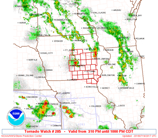
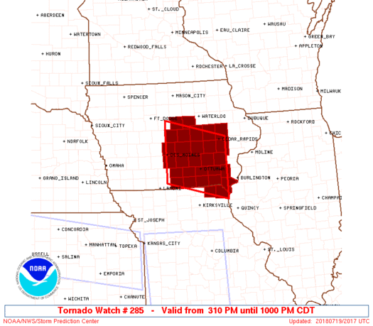
Tornado Watch Number 285
NWS Storm Prediction Center Norman OK
310 PM CDT Thu Jul 19 2018
The NWS Storm Prediction Center has issued a
* Tornado Watch for portions of
East-central and Southeast Iowa
Far Northeast Missouri
* Effective this Thursday afternoon and evening from 310 PM until
1000 PM CDT.
* Primary threats include...
A couple tornadoes possible
Scattered large hail and isolated very large hail events to 2
inches in diameter likely
Isolated damaging wind gusts to 70 mph possible
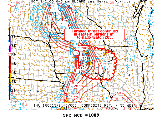
SUMMARY...The air mass continues to steadily destabilize at mid
afternoon across southern into central Iowa where a moist
environment otherwise exists. Strong winds through a deep layer, in
conjunction with sufficiently strong low-level winds, would appear
to support a supercell-related tornado risk aside from severe
hail/wind potential.
The tornado watch area is approximately along and 60 statute miles
north and south of a line from 5 miles north of Des Moines IA to 50
miles east of Ottumwa IA. For a complete depiction of the watch see
the associated watch outline update (WOUS64 KWNS WOU5).
PRECAUTIONARY/PREPAREDNESS ACTIONS...
REMEMBER...A Tornado Watch means conditions are favorable for
tornadoes and severe thunderstorms in and close to the watch
area. Persons in these areas should be on the lookout for
threatening weather conditions and listen for later statements
and possible warnings.
&&
OTHER WATCH INFORMATION...CONTINUE...WW 283...WW 284...
AVIATION...Tornadoes and a few severe thunderstorms with hail
surface and aloft to 2 inches. Extreme turbulence and surface wind
gusts to 60 knots. A few cumulonimbi with maximum tops to 500. Mean
storm motion vector 27025.
...Guyer
   SEL5

   URGENT - IMMEDIATE BROADCAST REQUESTED
   Tornado Watch Number 285
   NWS Storm Prediction Center Norman OK
   310 PM CDT Thu Jul 19 2018

   The NWS Storm Prediction Center has issued a

   * Tornado Watch for portions of
     East-central and Southeast Iowa
     Far Northeast Missouri

   * Effective this Thursday afternoon and evening from 310 PM until
     1000 PM CDT.

   * Primary threats include...
     A couple tornadoes possible
     Scattered large hail and isolated very large hail events to 2
       inches in diameter likely
     Isolated damaging wind gusts to 70 mph possible

   SUMMARY...The air mass continues to steadily destabilize at mid
   afternoon across southern into central Iowa where a moist
   environment otherwise exists. Strong winds through a deep layer, in
   conjunction with sufficiently strong low-level winds, would appear
   to support a supercell-related tornado risk aside from severe
   hail/wind potential.

   The tornado watch area is approximately along and 60 statute miles
   north and south of a line from 5 miles north of Des Moines IA to 50
   miles east of Ottumwa IA. For a complete depiction of the watch see
   the associated watch outline update (WOUS64 KWNS WOU5).

   PRECAUTIONARY/PREPAREDNESS ACTIONS...

   REMEMBER...A Tornado Watch means conditions are favorable for
   tornadoes and severe thunderstorms in and close to the watch
   area. Persons in these areas should be on the lookout for
   threatening weather conditions and listen for later statements
   and possible warnings.

   &&

   OTHER WATCH INFORMATION...CONTINUE...WW 283...WW 284...

   AVIATION...Tornadoes and a few severe thunderstorms with hail
   surface and aloft to 2 inches. Extreme turbulence and surface wind
   gusts to 60 knots. A few cumulonimbi with maximum tops to 500. Mean
   storm motion vector 27025.

   ...Guyer
 Note:
The Aviation Watch (SAW) product is an approximation to the watch area.
The actual watch is depicted by the shaded areas.
Note:
The Aviation Watch (SAW) product is an approximation to the watch area.
The actual watch is depicted by the shaded areas.
   SAW5
   WW 285 TORNADO IA MO 192010Z - 200300Z
   AXIS..60 STATUTE MILES NORTH AND SOUTH OF LINE..
   5N DSM/DES MOINES IA/ - 50E OTM/OTTUMWA IA/
   ..AVIATION COORDS.. 50NM N/S /10N DSM - 26SSE IOW/
   HAIL SURFACE AND ALOFT..2 INCHES. WIND GUSTS..60 KNOTS.
   MAX TOPS TO 500. MEAN STORM MOTION VECTOR 27025.

   LAT...LON 42479366 41959148 40229148 40729366

   THIS IS AN APPROXIMATION TO THE WATCH AREA.  FOR A
   COMPLETE DEPICTION OF THE WATCH SEE WOUS64 KWNS
   FOR WOU5.
Watch 285 Status Report Messages:
STATUS REPORT #4 ON WW 285

VALID 200140Z - 200240Z

SEVERE WEATHER THREAT CONTINUES RIGHT OF A LINE FROM 20 NNE IRK
TO 40 NNE IRK TO 10 W BRL.

..BENTLEY..07/20/18

ATTN...WFO...DMX...DVN...

&&

STATUS REPORT FOR WT 285

SEVERE WEATHER THREAT CONTINUES FOR THE FOLLOWING AREAS

IAC111-200240-

IA
.    IOWA COUNTIES INCLUDED ARE

LEE
$$


MOC045-199-200240-

MO
.    MISSOURI COUNTIES INCLUDED ARE

CLARK		     SCOTLAND
$$


THE WATCH STATUS MESSAGE IS FOR GUIDANCE PURPOSES ONLY.  PLEASE
REFER TO WATCH COUNTY NOTIFICATION STATEMENTS FOR OFFICIAL
INFORMATION ON COUNTIES...INDEPENDENT CITIES AND MARINE ZONES
CLEARED FROM SEVERE THUNDERSTORM AND TORNADO WATCHES.
$$

STATUS REPORT #3 ON WW 285

VALID 200040Z - 200140Z

SEVERE WEATHER THREAT CONTINUES RIGHT OF A LINE FROM 20 NNE IRK
TO 35 SSE OTM TO 15 WNW BRL.

..BENTLEY..07/20/18

ATTN...WFO...DMX...DVN...

&&

STATUS REPORT FOR WT 285

SEVERE WEATHER THREAT CONTINUES FOR THE FOLLOWING AREAS

IAC111-200140-

IA
.    IOWA COUNTIES INCLUDED ARE

LEE
$$


MOC045-199-200140-

MO
.    MISSOURI COUNTIES INCLUDED ARE

CLARK		     SCOTLAND
$$


THE WATCH STATUS MESSAGE IS FOR GUIDANCE PURPOSES ONLY.  PLEASE
REFER TO WATCH COUNTY NOTIFICATION STATEMENTS FOR OFFICIAL
INFORMATION ON COUNTIES...INDEPENDENT CITIES AND MARINE ZONES
CLEARED FROM SEVERE THUNDERSTORM AND TORNADO WATCHES.
$$

STATUS REPORT #2 ON WW 285

VALID 192350Z - 200040Z

SEVERE WEATHER THREAT CONTINUES RIGHT OF A LINE FROM 20 N IRK TO
25 SSE OTM TO 40 SSE CID.

FOR ADDITIONAL INFORMATION SEE MESOSCALE DISCUSSION 1091

..BENTLEY..07/19/18

ATTN...WFO...DMX...DVN...

&&

STATUS REPORT FOR WT 285

SEVERE WEATHER THREAT CONTINUES FOR THE FOLLOWING AREAS

IAC087-111-177-200040-

IA
.    IOWA COUNTIES INCLUDED ARE

HENRY		     LEE		 VAN BUREN
$$


MOC045-199-200040-

MO
.    MISSOURI COUNTIES INCLUDED ARE

CLARK		     SCOTLAND
$$


THE WATCH STATUS MESSAGE IS FOR GUIDANCE PURPOSES ONLY.  PLEASE
REFER TO WATCH COUNTY NOTIFICATION STATEMENTS FOR OFFICIAL
INFORMATION ON COUNTIES...INDEPENDENT CITIES AND MARINE ZONES
CLEARED FROM SEVERE THUNDERSTORM AND TORNADO WATCHES.
$$

STATUS REPORT #1 ON WW 285

VALID 192245Z - 192340Z

SEVERE WEATHER THREAT CONTINUES RIGHT OF A LINE FROM 25 N IRK TO
10 SW OTM TO 10 NNE OTM TO 35 W CID TO 5 WNW ALO.

FOR ADDITIONAL INFORMATION SEE MESOSCALE DISCUSSION 1089

..BENTLEY..07/19/18

ATTN...WFO...DMX...DVN...

&&

STATUS REPORT FOR WT 285

SEVERE WEATHER THREAT CONTINUES FOR THE FOLLOWING AREAS

IAC011-051-087-095-101-103-107-111-113-177-179-183-192340-

IA
.    IOWA COUNTIES INCLUDED ARE

BENTON		     DAVIS		 HENRY
IOWA		     JEFFERSON		 JOHNSON
KEOKUK		     LEE		 LINN
VAN BUREN	     WAPELLO		 WASHINGTON
$$


MOC045-199-192340-

MO
.    MISSOURI COUNTIES INCLUDED ARE

CLARK		     SCOTLAND
$$


THE WATCH STATUS MESSAGE IS FOR GUIDANCE PURPOSES ONLY.  PLEASE
REFER TO WATCH COUNTY NOTIFICATION STATEMENTS FOR OFFICIAL
INFORMATION ON COUNTIES...INDEPENDENT CITIES AND MARINE ZONES
CLEARED FROM SEVERE THUNDERSTORM AND TORNADO WATCHES.
$$
Note:
Click for Complete Product Text.
Tornadoes
Probability of 2 or more tornadoes
|
Mod (40%)
|
Probability of 1 or more strong (EF2-EF5) tornadoes
|
Low (10%)
|
Wind
Probability of 10 or more severe wind events
|
Mod (30%)
|
Probability of 1 or more wind events > 65 knots
|
Low (10%)
|
Hail
Probability of 10 or more severe hail events
|
Mod (60%)
|
Probability of 1 or more hailstones > 2 inches
|
Mod (60%)
|
Combined Severe Hail/Wind
Probability of 6 or more combined severe hail/wind events
|
High (80%)
|
For each watch, probabilities for particular events inside the watch
(listed above in each table) are determined by the issuing forecaster.
The "Low" category contains probability values ranging from less than 2%
to 20% (EF2-EF5 tornadoes), less than 5% to 20% (all other probabilities),
"Moderate" from 30% to 60%, and "High" from 70% to greater than 95%.
High values are bolded and lighter in color to provide awareness of
an increased threat for a particular event.


 @NWSSPC