Note:
The expiration time in the watch graphic is amended if the watch is
replaced, cancelled or extended.
Note:
Note:
The expiration time in the watch graphic is amended if the watch is
replaced, cancelled or extended.
Note: Click for
Watch Status Reports.
SEL3
URGENT - IMMEDIATE BROADCAST REQUESTED
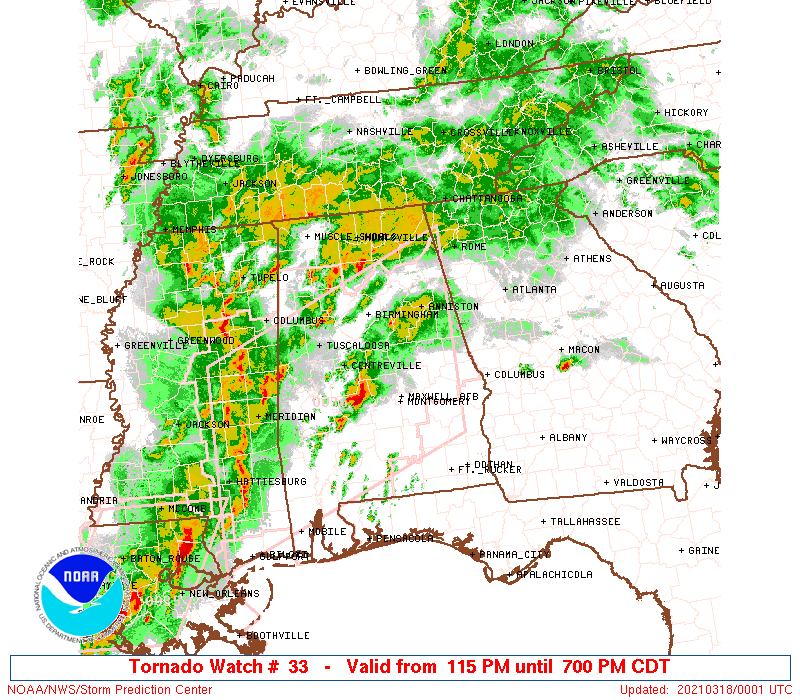
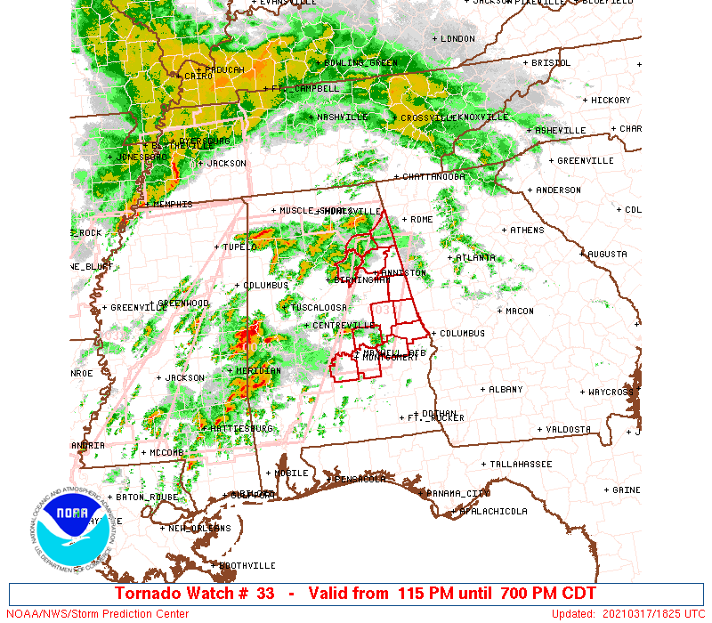
Tornado Watch Number 33
NWS Storm Prediction Center Norman OK
115 PM CDT Wed Mar 17 2021
The NWS Storm Prediction Center has issued a
* Tornado Watch for portions of
Central to eastern Alabama
* Effective this Wednesday afternoon and evening from 115 PM
until 700 PM CDT.
* Primary threats include...
A few tornadoes and a couple intense tornadoes likely
Scattered damaging winds and isolated significant gusts to 75
mph possible
Isolated very large hail events to 2 inches in diameter possible
SUMMARY...Discrete supercells across central Alabama may spread into
portions of eastern Alabama prior to early evening. All hazard types
are possible, with the greatest tornado threat expected in
east-central Alabama.
The tornado watch area is approximately along and 30 statute miles
east and west of a line from 30 miles east northeast of Gadsden AL
to 15 miles south southeast of Montgomery AL. For a complete
depiction of the watch see the associated watch outline update
(WOUS64 KWNS WOU3).
PRECAUTIONARY/PREPAREDNESS ACTIONS...
REMEMBER...A Tornado Watch means conditions are favorable for
tornadoes and severe thunderstorms in and close to the watch
area. Persons in these areas should be on the lookout for
threatening weather conditions and listen for later statements
and possible warnings.
&&
OTHER WATCH INFORMATION...CONTINUE...WW 29...WW 30...WW 31...WW
32...
AVIATION...Tornadoes and a few severe thunderstorms with hail
surface and aloft to 2 inches. Extreme turbulence and surface wind
gusts to 65 knots. A few cumulonimbi with maximum tops to 500. Mean
storm motion vector 25030.
...Grams

   SEL3

   URGENT - IMMEDIATE BROADCAST REQUESTED
   Tornado Watch Number 33
   NWS Storm Prediction Center Norman OK
   115 PM CDT Wed Mar 17 2021

   The NWS Storm Prediction Center has issued a

   * Tornado Watch for portions of
     Central to eastern Alabama

   * Effective this Wednesday afternoon and evening from 115 PM
     until 700 PM CDT.

   * Primary threats include...
     A few tornadoes and a couple intense tornadoes likely
     Scattered damaging winds and isolated significant gusts to 75
       mph possible
     Isolated very large hail events to 2 inches in diameter possible

   SUMMARY...Discrete supercells across central Alabama may spread into
   portions of eastern Alabama prior to early evening. All hazard types
   are possible, with the greatest tornado threat expected in
   east-central Alabama.

   The tornado watch area is approximately along and 30 statute miles
   east and west of a line from 30 miles east northeast of Gadsden AL
   to 15 miles south southeast of Montgomery AL. For a complete
   depiction of the watch see the associated watch outline update
   (WOUS64 KWNS WOU3).

   PRECAUTIONARY/PREPAREDNESS ACTIONS...

   REMEMBER...A Tornado Watch means conditions are favorable for
   tornadoes and severe thunderstorms in and close to the watch
   area. Persons in these areas should be on the lookout for
   threatening weather conditions and listen for later statements
   and possible warnings.

   &&

   OTHER WATCH INFORMATION...CONTINUE...WW 29...WW 30...WW 31...WW
   32...

   AVIATION...Tornadoes and a few severe thunderstorms with hail
   surface and aloft to 2 inches. Extreme turbulence and surface wind
   gusts to 65 knots. A few cumulonimbi with maximum tops to 500. Mean
   storm motion vector 25030.

   ...Grams
 Note:
The Aviation Watch (SAW) product is an approximation to the watch area.
The actual watch is depicted by the shaded areas.
Note:
The Aviation Watch (SAW) product is an approximation to the watch area.
The actual watch is depicted by the shaded areas.
   SAW3
   WW 33 TORNADO AL 171815Z - 180000Z
   AXIS..30 STATUTE MILES EAST AND WEST OF LINE..
   30ENE GAD/GADSDEN AL/ - 15SSE MGM/MONTGOMERY AL/
   ..AVIATION COORDS.. 25NM E/W /54SSW GQO - 8S MGM/
   HAIL SURFACE AND ALOFT..2 INCHES. WIND GUSTS..65 KNOTS.
   MAX TOPS TO 500. MEAN STORM MOTION VECTOR 25030.

   LAT...LON 34138507 32098579 32098681 34138612

   THIS IS AN APPROXIMATION TO THE WATCH AREA.  FOR A
   COMPLETE DEPICTION OF THE WATCH SEE WOUS64 KWNS
   FOR WOU3.
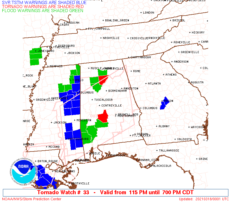
Watch 33 Status Report Messages:
STATUS REPORT #4 ON WW 33

VALID 172340Z - 180000Z

THE SEVERE WEATHER THREAT CONTINUES ACROSS THE ENTIRE WATCH AREA.

WW 33 WILL BE REPLACED WITH NEW WW PRIOR TO 18/00Z.

..KERR..03/17/21

ATTN...WFO...BMX...

&&

STATUS REPORT FOR WT 33

SEVERE WEATHER THREAT CONTINUES FOR THE FOLLOWING AREAS

ALC015-017-019-029-051-055-081-085-087-101-111-115-123-180000-

AL
.    ALABAMA COUNTIES INCLUDED ARE

CALHOUN 	     CHAMBERS		 CHEROKEE
CLEBURNE	     ELMORE		 ETOWAH
LEE		     LOWNDES		 MACON
MONTGOMERY	     RANDOLPH		 ST. CLAIR
TALLAPOOSA
$$


THE WATCH STATUS MESSAGE IS FOR GUIDANCE PURPOSES ONLY.  PLEASE
REFER TO WATCH COUNTY NOTIFICATION STATEMENTS FOR OFFICIAL
INFORMATION ON COUNTIES...INDEPENDENT CITIES AND MARINE ZONES
CLEARED FROM SEVERE THUNDERSTORM AND TORNADO WATCHES.
$$

STATUS REPORT #3 ON WW 33

VALID 172145Z - 172240Z

THE SEVERE WEATHER THREAT CONTINUES ACROSS THE ENTIRE WATCH AREA.

..KERR..03/17/21

ATTN...WFO...BMX...

&&

STATUS REPORT FOR WT 33

SEVERE WEATHER THREAT CONTINUES FOR THE FOLLOWING AREAS

ALC015-017-019-029-051-055-081-085-087-101-111-115-123-172240-

AL
.    ALABAMA COUNTIES INCLUDED ARE

CALHOUN 	     CHAMBERS		 CHEROKEE
CLEBURNE	     ELMORE		 ETOWAH
LEE		     LOWNDES		 MACON
MONTGOMERY	     RANDOLPH		 ST. CLAIR
TALLAPOOSA
$$


THE WATCH STATUS MESSAGE IS FOR GUIDANCE PURPOSES ONLY.  PLEASE
REFER TO WATCH COUNTY NOTIFICATION STATEMENTS FOR OFFICIAL
INFORMATION ON COUNTIES...INDEPENDENT CITIES AND MARINE ZONES
CLEARED FROM SEVERE THUNDERSTORM AND TORNADO WATCHES.
$$

STATUS REPORT #2 ON WW 33

VALID 172055Z - 172140Z

THE SEVERE WEATHER THREAT CONTINUES ACROSS THE ENTIRE WATCH AREA.

..BENTLEY..03/17/21

ATTN...WFO...BMX...

&&

STATUS REPORT FOR WT 33

SEVERE WEATHER THREAT CONTINUES FOR THE FOLLOWING AREAS

ALC015-017-019-029-051-055-081-085-087-101-111-115-123-172140-

AL
.    ALABAMA COUNTIES INCLUDED ARE

CALHOUN 	     CHAMBERS		 CHEROKEE
CLEBURNE	     ELMORE		 ETOWAH
LEE		     LOWNDES		 MACON
MONTGOMERY	     RANDOLPH		 ST. CLAIR
TALLAPOOSA
$$


THE WATCH STATUS MESSAGE IS FOR GUIDANCE PURPOSES ONLY.  PLEASE
REFER TO WATCH COUNTY NOTIFICATION STATEMENTS FOR OFFICIAL
INFORMATION ON COUNTIES...INDEPENDENT CITIES AND MARINE ZONES
CLEARED FROM SEVERE THUNDERSTORM AND TORNADO WATCHES.
$$

STATUS REPORT #1 ON WW 33

VALID 171930Z - 172040Z

THE SEVERE WEATHER THREAT CONTINUES ACROSS THE ENTIRE WATCH AREA.

..BENTLEY..03/17/21

ATTN...WFO...BMX...

&&

STATUS REPORT FOR WT 33

SEVERE WEATHER THREAT CONTINUES FOR THE FOLLOWING AREAS

ALC015-017-019-029-051-055-081-085-087-101-111-115-123-172040-

AL
.    ALABAMA COUNTIES INCLUDED ARE

CALHOUN 	     CHAMBERS		 CHEROKEE
CLEBURNE	     ELMORE		 ETOWAH
LEE		     LOWNDES		 MACON
MONTGOMERY	     RANDOLPH		 ST. CLAIR
TALLAPOOSA
$$


THE WATCH STATUS MESSAGE IS FOR GUIDANCE PURPOSES ONLY.  PLEASE
REFER TO WATCH COUNTY NOTIFICATION STATEMENTS FOR OFFICIAL
INFORMATION ON COUNTIES...INDEPENDENT CITIES AND MARINE ZONES
CLEARED FROM SEVERE THUNDERSTORM AND TORNADO WATCHES.
$$
Note:
Click for Complete Product Text.
Tornadoes
Probability of 2 or more tornadoes
|
High (70%)
|
Probability of 1 or more strong (EF2-EF5) tornadoes
|
Mod (60%)
|
Wind
Probability of 10 or more severe wind events
|
Mod (40%)
|
Probability of 1 or more wind events > 65 knots
|
Mod (30%)
|
Hail
Probability of 10 or more severe hail events
|
Mod (30%)
|
Probability of 1 or more hailstones > 2 inches
|
Mod (30%)
|
Combined Severe Hail/Wind
Probability of 6 or more combined severe hail/wind events
|
High (70%)
|
For each watch, probabilities for particular events inside the watch
(listed above in each table) are determined by the issuing forecaster.
The "Low" category contains probability values ranging from less than 2%
to 20% (EF2-EF5 tornadoes), less than 5% to 20% (all other probabilities),
"Moderate" from 30% to 60%, and "High" from 70% to greater than 95%.
High values are bolded and lighter in color to provide awareness of
an increased threat for a particular event.


 @NWSSPC