 Note:
The expiration time in the watch graphic is amended if the watch is
replaced, cancelled or extended.
Note:
Note:
The expiration time in the watch graphic is amended if the watch is
replaced, cancelled or extended.
Note: Click for
Watch Status Reports.
SEL4
URGENT - IMMEDIATE BROADCAST REQUESTED
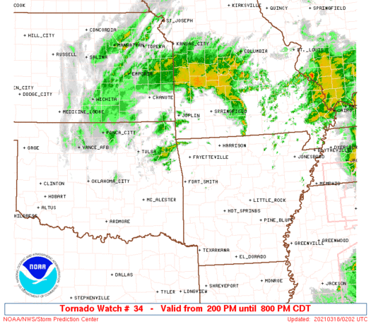
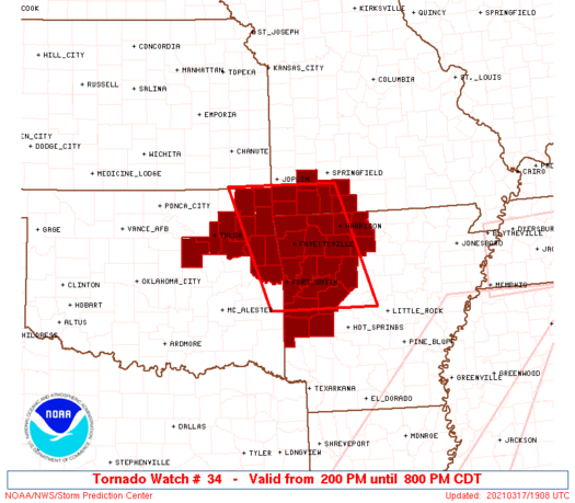
Tornado Watch Number 34
NWS Storm Prediction Center Norman OK
200 PM CDT Wed Mar 17 2021
The NWS Storm Prediction Center has issued a
* Tornado Watch for portions of
Northwest Arkansas
Southwest Missouri
Northeast Oklahoma
* Effective this Wednesday afternoon and evening from 200 PM
until 800 PM CDT.
* Primary threats include...
A couple tornadoes possible
Isolated very large hail events to 2 inches in diameter possible
Isolated damaging wind gusts to 65 mph possible
SUMMARY...Multiple supercells may intensify across northeast
Oklahoma before spreading/developing into parts of northwest
Arkansas and southwest Missouri. Greatest tornado threat should be
in a narrow corridor near the surface cyclone and warm front.
The tornado watch area is approximately along and 65 statute miles
east and west of a line from 30 miles west northwest of Monett MO to
40 miles southwest of Russellville AR. For a complete depiction of
the watch see the associated watch outline update (WOUS64 KWNS
WOU4).
PRECAUTIONARY/PREPAREDNESS ACTIONS...
REMEMBER...A Tornado Watch means conditions are favorable for
tornadoes and severe thunderstorms in and close to the watch
area. Persons in these areas should be on the lookout for
threatening weather conditions and listen for later statements
and possible warnings.
&&
OTHER WATCH INFORMATION...CONTINUE...WW 29...WW 30...WW 31...WW
32...WW 33...
AVIATION...Tornadoes and a few severe thunderstorms with hail
surface and aloft to 2 inches. Extreme turbulence and surface wind
gusts to 55 knots. A few cumulonimbi with maximum tops to 400. Mean
storm motion vector 22025.
...Grams
 Note:
The Aviation Watch (SAW) product is an approximation to the watch area.
The actual watch is depicted by the shaded areas.
Note:
The Aviation Watch (SAW) product is an approximation to the watch area.
The actual watch is depicted by the shaded areas.
   SAW4
   WW 34 TORNADO AR MO OK 171900Z - 180100Z
   AXIS..65 STATUTE MILES EAST AND WEST OF LINE..
   30WNW UMN/MONETT MO/ - 40SW RUE/RUSSELLVILLE AR/
   ..AVIATION COORDS.. 55NM E/W /39E OSW - 47SE FSM/
   HAIL SURFACE AND ALOFT..2 INCHES. WIND GUSTS..55 KNOTS.
   MAX TOPS TO 400. MEAN STORM MOTION VECTOR 22025.

   LAT...LON 37049322 34839244 34839473 37049558

   THIS IS AN APPROXIMATION TO THE WATCH AREA.  FOR A
   COMPLETE DEPICTION OF THE WATCH SEE WOUS64 KWNS
   FOR WOU4.
Watch 34 Status Report Messages:
STATUS REPORT #3 ON WW 34

VALID 172350Z - 180040Z

SEVERE WEATHER THREAT CONTINUES RIGHT OF A LINE FROM 35 NE RUE TO
25 N RUE TO 35 ESE FYV TO 30 NNE FYV TO 15 WSW UMN TO 15 ESE JLN.

..LYONS..03/17/21

ATTN...WFO...TSA...LZK...SGF...

&&

STATUS REPORT FOR WT 34

SEVERE WEATHER THREAT CONTINUES FOR THE FOLLOWING AREAS

ARC009-089-101-129-180040-

AR
.    ARKANSAS COUNTIES INCLUDED ARE

BOONE		     MARION		 NEWTON
SEARCY
$$


MOC009-043-077-109-209-213-180040-

MO
.    MISSOURI COUNTIES INCLUDED ARE

BARRY		     CHRISTIAN		 GREENE
LAWRENCE	     STONE		 TANEY
$$


THE WATCH STATUS MESSAGE IS FOR GUIDANCE PURPOSES ONLY.  PLEASE
REFER TO WATCH COUNTY NOTIFICATION STATEMENTS FOR OFFICIAL
INFORMATION ON COUNTIES...INDEPENDENT CITIES AND MARINE ZONES
CLEARED FROM SEVERE THUNDERSTORM AND TORNADO WATCHES.
$$

STATUS REPORT #2 ON WW 34

VALID 172225Z - 172340Z

SEVERE WEATHER THREAT CONTINUES RIGHT OF A LINE FROM 20 ESE RKR
TO 10 WNW FSM TO 25 WNW FYV TO 20 SSW GMJ TO 35 W JLN.

..LYONS..03/17/21

ATTN...WFO...TSA...LZK...SGF...

&&

STATUS REPORT FOR WT 34

SEVERE WEATHER THREAT CONTINUES FOR THE FOLLOWING AREAS

ARC007-009-015-033-047-071-083-087-089-097-101-115-127-129-131-
143-149-172340-

AR
.    ARKANSAS COUNTIES INCLUDED ARE

BENTON		     BOONE		 CARROLL
CRAWFORD	     FRANKLIN		 JOHNSON
LOGAN		     MADISON		 MARION
MONTGOMERY	     NEWTON		 POPE
SCOTT		     SEARCY		 SEBASTIAN
WASHINGTON	     YELL
$$


MOC009-043-109-119-145-209-213-172340-

MO
.    MISSOURI COUNTIES INCLUDED ARE

BARRY		     CHRISTIAN		 LAWRENCE
MCDONALD	     NEWTON		 STONE
TANEY
$$


OKC041-115-172340-

OK
.    OKLAHOMA COUNTIES INCLUDED ARE

DELAWARE	     OTTAWA
$$


THE WATCH STATUS MESSAGE IS FOR GUIDANCE PURPOSES ONLY.  PLEASE
REFER TO WATCH COUNTY NOTIFICATION STATEMENTS FOR OFFICIAL
INFORMATION ON COUNTIES...INDEPENDENT CITIES AND MARINE ZONES
CLEARED FROM SEVERE THUNDERSTORM AND TORNADO WATCHES.
$$

STATUS REPORT #1 ON WW 34

VALID 172050Z - 172140Z

SEVERE WEATHER THREAT CONTINUES RIGHT OF A LINE FROM 40 NE DEQ TO
20 ESE FSM TO 20 SSW FYV TO 35 WSW FYV TO 15 N MKO TO 30 W MKO.

FOR ADDITIONAL INFORMATION SEE MESOSCALE DISCUSSION 211

..BENTLEY..03/17/21

ATTN...WFO...TSA...LZK...SGF...

&&

STATUS REPORT FOR WT 34

SEVERE WEATHER THREAT CONTINUES FOR THE FOLLOWING AREAS

ARC007-009-015-033-047-071-083-087-089-097-101-115-127-129-131-
143-149-172140-

AR
.    ARKANSAS COUNTIES INCLUDED ARE

BENTON		     BOONE		 CARROLL
CRAWFORD	     FRANKLIN		 JOHNSON
LOGAN		     MADISON		 MARION
MONTGOMERY	     NEWTON		 POPE
SCOTT		     SEARCY		 SEBASTIAN
WASHINGTON	     YELL
$$


MOC009-043-109-119-145-209-213-172140-

MO
.    MISSOURI COUNTIES INCLUDED ARE

BARRY		     CHRISTIAN		 LAWRENCE
MCDONALD	     NEWTON		 STONE
TANEY
$$


OKC001-021-035-041-097-115-131-135-143-145-172140-

OK
.    OKLAHOMA COUNTIES INCLUDED ARE

ADAIR		     CHEROKEE		 CRAIG
DELAWARE	     MAYES		 OTTAWA
ROGERS		     SEQUOYAH		 TULSA
WAGONER
$$


THE WATCH STATUS MESSAGE IS FOR GUIDANCE PURPOSES ONLY.  PLEASE
REFER TO WATCH COUNTY NOTIFICATION STATEMENTS FOR OFFICIAL
INFORMATION ON COUNTIES...INDEPENDENT CITIES AND MARINE ZONES
CLEARED FROM SEVERE THUNDERSTORM AND TORNADO WATCHES.
$$
Note:
Click for Complete Product Text.
Tornadoes
Probability of 2 or more tornadoes
|
Mod (40%)
|
Probability of 1 or more strong (EF2-EF5) tornadoes
|
Low (10%)
|
Wind
Probability of 10 or more severe wind events
|
Low (20%)
|
Probability of 1 or more wind events > 65 knots
|
Low (10%)
|
Hail
Probability of 10 or more severe hail events
|
Mod (30%)
|
Probability of 1 or more hailstones > 2 inches
|
Mod (30%)
|
Combined Severe Hail/Wind
Probability of 6 or more combined severe hail/wind events
|
Mod (50%)
|
For each watch, probabilities for particular events inside the watch
(listed above in each table) are determined by the issuing forecaster.
The "Low" category contains probability values ranging from less than 2%
to 20% (EF2-EF5 tornadoes), less than 5% to 20% (all other probabilities),
"Moderate" from 30% to 60%, and "High" from 70% to greater than 95%.
High values are bolded and lighter in color to provide awareness of
an increased threat for a particular event.


 @NWSSPC


