 Note:
The expiration time in the watch graphic is amended if the watch is
replaced, cancelled or extended.
Note:
Note:
The expiration time in the watch graphic is amended if the watch is
replaced, cancelled or extended.
Note: Click for
Watch Status Reports.
SEL9
URGENT - IMMEDIATE BROADCAST REQUESTED
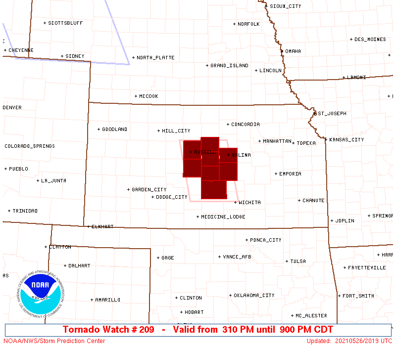
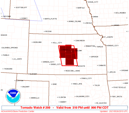
Tornado Watch Number 209
NWS Storm Prediction Center Norman OK
310 PM CDT Wed May 26 2021
The NWS Storm Prediction Center has issued a
* Tornado Watch for portions of
Central Kansas
* Effective this Wednesday afternoon and evening from 310 PM
until 900 PM CDT.
* Primary threats include...
A few tornadoes and a couple intense tornadoes likely
Widespread large hail expected with scattered very large hail
events to 3 inches in diameter likely
Scattered damaging wind gusts to 70 mph likely
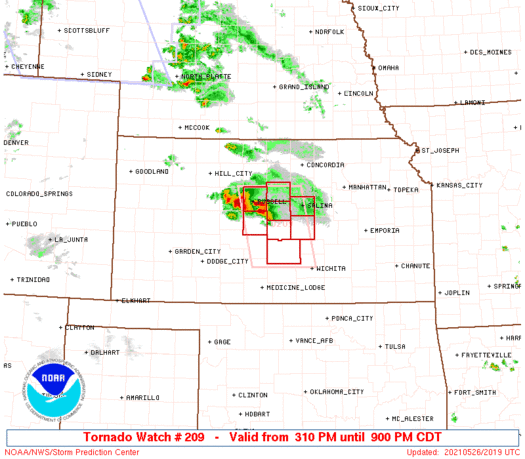
SUMMARY...A small and slow-moving cluster of supercell thunderstorms
will likely persist for several more hours, posing a risk of very
large hail, damaging winds, and isolated tornadoes.
The tornado watch area is approximately along and 40 statute miles
east and west of a line from 30 miles northeast of Russell KS to 30
miles south southwest of Hutchinson KS. For a complete depiction of
the watch see the associated watch outline update (WOUS64 KWNS
WOU9).
PRECAUTIONARY/PREPAREDNESS ACTIONS...
REMEMBER...A Tornado Watch means conditions are favorable for
tornadoes and severe thunderstorms in and close to the watch
area. Persons in these areas should be on the lookout for
threatening weather conditions and listen for later statements
and possible warnings.
&&
OTHER WATCH INFORMATION...CONTINUE...WW 205...WW 206...WW
207...WW 208...
AVIATION...Tornadoes and a few severe thunderstorms with hail
surface and aloft to 3 inches. Extreme turbulence and surface wind
gusts to 60 knots. A few cumulonimbi with maximum tops to 600. Mean
storm motion vector 29020.
...Hart
   SEL9

   URGENT - IMMEDIATE BROADCAST REQUESTED
   Tornado Watch Number 209
   NWS Storm Prediction Center Norman OK
   310 PM CDT Wed May 26 2021

   The NWS Storm Prediction Center has issued a

   * Tornado Watch for portions of
     Central Kansas

   * Effective this Wednesday afternoon and evening from 310 PM
     until 900 PM CDT.

   * Primary threats include...
     A few tornadoes and a couple intense tornadoes likely
     Widespread large hail expected with scattered very large hail
       events to 3 inches in diameter likely
     Scattered damaging wind gusts to 70 mph likely

   SUMMARY...A small and slow-moving cluster of supercell thunderstorms
   will likely persist for several more hours, posing a risk of very
   large hail, damaging winds, and isolated tornadoes.

   The tornado watch area is approximately along and 40 statute miles
   east and west of a line from 30 miles northeast of Russell KS to 30
   miles south southwest of Hutchinson KS. For a complete depiction of
   the watch see the associated watch outline update (WOUS64 KWNS
   WOU9).

   PRECAUTIONARY/PREPAREDNESS ACTIONS...

   REMEMBER...A Tornado Watch means conditions are favorable for
   tornadoes and severe thunderstorms in and close to the watch
   area. Persons in these areas should be on the lookout for
   threatening weather conditions and listen for later statements
   and possible warnings.

   &&

   OTHER WATCH INFORMATION...CONTINUE...WW 205...WW 206...WW
   207...WW 208...

   AVIATION...Tornadoes and a few severe thunderstorms with hail
   surface and aloft to 3 inches. Extreme turbulence and surface wind
   gusts to 60 knots. A few cumulonimbi with maximum tops to 600. Mean
   storm motion vector 29020.

   ...Hart
 Note:
The Aviation Watch (SAW) product is an approximation to the watch area.
The actual watch is depicted by the shaded areas.
Note:
The Aviation Watch (SAW) product is an approximation to the watch area.
The actual watch is depicted by the shaded areas.
   SAW9
   WW 209 TORNADO KS 262010Z - 270200Z
   AXIS..40 STATUTE MILES EAST AND WEST OF LINE..
   30NE RSL/RUSSELL KS/ - 30SSW HUT/HUTCHINSON KS/
   ..AVIATION COORDS.. 35NM E/W /40WNW SLN - 24WSW ICT/
   HAIL SURFACE AND ALOFT..3 INCHES. WIND GUSTS..60 KNOTS.
   MAX TOPS TO 600. MEAN STORM MOTION VECTOR 29020.

   LAT...LON 39169768 37669735 37669881 39169917

   THIS IS AN APPROXIMATION TO THE WATCH AREA.  FOR A
   COMPLETE DEPICTION OF THE WATCH SEE WOUS64 KWNS
   FOR WOU9.
Watch 209 Status Report Messages:
STATUS REPORT #4 ON WW 209

VALID 270045Z - 270140Z

THE SEVERE WEATHER THREAT CONTINUES ACROSS THE ENTIRE WATCH AREA.

..KERR..05/27/21

ATTN...WFO...ICT...

&&

STATUS REPORT FOR WT 209

SEVERE WEATHER THREAT CONTINUES FOR THE FOLLOWING AREAS

KSC009-053-105-113-155-159-167-169-270140-

KS
.    KANSAS COUNTIES INCLUDED ARE

BARTON		     ELLSWORTH		 LINCOLN
MCPHERSON	     RENO		 RICE
RUSSELL 	     SALINE
$$


THE WATCH STATUS MESSAGE IS FOR GUIDANCE PURPOSES ONLY.  PLEASE
REFER TO WATCH COUNTY NOTIFICATION STATEMENTS FOR OFFICIAL
INFORMATION ON COUNTIES...INDEPENDENT CITIES AND MARINE ZONES
CLEARED FROM SEVERE THUNDERSTORM AND TORNADO WATCHES.
$$

STATUS REPORT #3 ON WW 209

VALID 262320Z - 270040Z

THE SEVERE WEATHER THREAT CONTINUES ACROSS THE ENTIRE WATCH AREA.

..KERR..05/26/21

ATTN...WFO...ICT...

&&

STATUS REPORT FOR WT 209

SEVERE WEATHER THREAT CONTINUES FOR THE FOLLOWING AREAS

KSC009-053-105-113-155-159-167-169-270040-

KS
.    KANSAS COUNTIES INCLUDED ARE

BARTON		     ELLSWORTH		 LINCOLN
MCPHERSON	     RENO		 RICE
RUSSELL 	     SALINE
$$


THE WATCH STATUS MESSAGE IS FOR GUIDANCE PURPOSES ONLY.  PLEASE
REFER TO WATCH COUNTY NOTIFICATION STATEMENTS FOR OFFICIAL
INFORMATION ON COUNTIES...INDEPENDENT CITIES AND MARINE ZONES
CLEARED FROM SEVERE THUNDERSTORM AND TORNADO WATCHES.
$$

STATUS REPORT #2 ON WW 209

VALID 262255Z - 262340Z

THE SEVERE WEATHER THREAT CONTINUES ACROSS THE ENTIRE WATCH AREA.

..KERR..05/26/21

ATTN...WFO...ICT...

&&

STATUS REPORT FOR WT 209

SEVERE WEATHER THREAT CONTINUES FOR THE FOLLOWING AREAS

KSC009-053-105-113-155-159-167-169-262340-

KS
.    KANSAS COUNTIES INCLUDED ARE

BARTON		     ELLSWORTH		 LINCOLN
MCPHERSON	     RENO		 RICE
RUSSELL 	     SALINE
$$


THE WATCH STATUS MESSAGE IS FOR GUIDANCE PURPOSES ONLY.  PLEASE
REFER TO WATCH COUNTY NOTIFICATION STATEMENTS FOR OFFICIAL
INFORMATION ON COUNTIES...INDEPENDENT CITIES AND MARINE ZONES
CLEARED FROM SEVERE THUNDERSTORM AND TORNADO WATCHES.
$$

STATUS REPORT #1 ON WW 209

VALID 262130Z - 262240Z

THE SEVERE WEATHER THREAT CONTINUES ACROSS THE ENTIRE WATCH AREA.

..KERR..05/26/21

ATTN...WFO...ICT...

&&

STATUS REPORT FOR WT 209

SEVERE WEATHER THREAT CONTINUES FOR THE FOLLOWING AREAS

KSC009-053-105-113-155-159-167-169-262240-

KS
.    KANSAS COUNTIES INCLUDED ARE

BARTON		     ELLSWORTH		 LINCOLN
MCPHERSON	     RENO		 RICE
RUSSELL 	     SALINE
$$


THE WATCH STATUS MESSAGE IS FOR GUIDANCE PURPOSES ONLY.  PLEASE
REFER TO WATCH COUNTY NOTIFICATION STATEMENTS FOR OFFICIAL
INFORMATION ON COUNTIES...INDEPENDENT CITIES AND MARINE ZONES
CLEARED FROM SEVERE THUNDERSTORM AND TORNADO WATCHES.
$$
Note:
Click for Complete Product Text.
Tornadoes
Probability of 2 or more tornadoes
|
Mod (60%)
|
Probability of 1 or more strong (EF2-EF5) tornadoes
|
Mod (60%)
|
Wind
Probability of 10 or more severe wind events
|
Mod (60%)
|
Probability of 1 or more wind events > 65 knots
|
Low (10%)
|
Hail
Probability of 10 or more severe hail events
|
High (>95%)
|
Probability of 1 or more hailstones > 2 inches
|
High (80%)
|
Combined Severe Hail/Wind
Probability of 6 or more combined severe hail/wind events
|
High (>95%)
|
For each watch, probabilities for particular events inside the watch
(listed above in each table) are determined by the issuing forecaster.
The "Low" category contains probability values ranging from less than 2%
to 20% (EF2-EF5 tornadoes), less than 5% to 20% (all other probabilities),
"Moderate" from 30% to 60%, and "High" from 70% to greater than 95%.
High values are bolded and lighter in color to provide awareness of
an increased threat for a particular event.


 @NWSSPC