 Note:
The expiration time in the watch graphic is amended if the watch is
replaced, cancelled or extended.
Note:
Note:
The expiration time in the watch graphic is amended if the watch is
replaced, cancelled or extended.
Note: Click for
Watch Status Reports.
SEL0
URGENT - IMMEDIATE BROADCAST REQUESTED
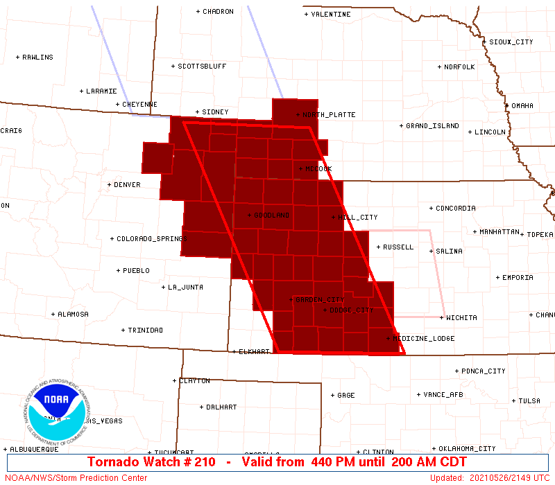
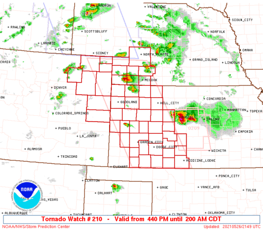
Tornado Watch Number 210
NWS Storm Prediction Center Norman OK
440 PM CDT Wed May 26 2021
The NWS Storm Prediction Center has issued a
* Tornado Watch for portions of
Northeastern and extreme eastern Colorado
Western Kansas
Southwestern Nebraska
* Effective this Wednesday afternoon and Thursday morning from
440 PM until 200 AM CDT.
...THIS IS A PARTICULARLY DANGEROUS SITUATION...
* Primary threats include...
Several tornadoes and a few intense tornadoes likely
Widespread large hail and scattered very large hail events to 4
inches in diameter likely
Scattered damaging winds and isolated significant gusts to 75
mph likely
SUMMARY...Several supercells should develop across western parts of
the watch area through this evening and spread northeastward to
eastward, offering tornadoes (some strong with EF2+ damage
capability), as well as severe to giant hail and locally severe
gusts. Clustering into one or more storm complexes with an
increased wind threat may occur later this evening.
The tornado watch area is approximately along and 75 statute miles
east and west of a line from 30 miles north northwest of Imperial NE
to 55 miles south southeast of Dodge City KS. For a complete
depiction of the watch see the associated watch outline update
(WOUS64 KWNS WOU0).
PRECAUTIONARY/PREPAREDNESS ACTIONS...
REMEMBER...A Tornado Watch means conditions are favorable for
tornadoes and severe thunderstorms in and close to the watch
area. Persons in these areas should be on the lookout for
threatening weather conditions and listen for later statements
and possible warnings.
&&
OTHER WATCH INFORMATION...CONTINUE...WW 205...WW 206...WW
207...WW 208...WW 209...
AVIATION...Tornadoes and a few severe thunderstorms with hail
surface and aloft to 4 inches. Extreme turbulence and surface wind
gusts to 65 knots. A few cumulonimbi with maximum tops to 600. Mean
storm motion vector 24025.
...Edwards
   SEL0

   URGENT - IMMEDIATE BROADCAST REQUESTED
   Tornado Watch Number 210
   NWS Storm Prediction Center Norman OK
   440 PM CDT Wed May 26 2021

   The NWS Storm Prediction Center has issued a

   * Tornado Watch for portions of
     Northeastern and extreme eastern Colorado
     Western Kansas
     Southwestern Nebraska

   * Effective this Wednesday afternoon and Thursday morning from
     440 PM until 200 AM CDT.

   ...THIS IS A PARTICULARLY DANGEROUS SITUATION...

   * Primary threats include...
     Several tornadoes and a few intense tornadoes likely
     Widespread large hail and scattered very large hail events to 4
       inches in diameter likely
     Scattered damaging winds and isolated significant gusts to 75
       mph likely

   SUMMARY...Several supercells should develop across western parts of
   the watch area through this evening and spread northeastward to
   eastward, offering tornadoes (some strong with EF2+ damage
   capability), as well as severe to giant hail and locally severe
   gusts.  Clustering into one or more storm complexes with an
   increased wind threat may occur later this evening.

   The tornado watch area is approximately along and 75 statute miles
   east and west of a line from 30 miles north northwest of Imperial NE
   to 55 miles south southeast of Dodge City KS. For a complete
   depiction of the watch see the associated watch outline update
   (WOUS64 KWNS WOU0).

   PRECAUTIONARY/PREPAREDNESS ACTIONS...

   REMEMBER...A Tornado Watch means conditions are favorable for
   tornadoes and severe thunderstorms in and close to the watch
   area. Persons in these areas should be on the lookout for
   threatening weather conditions and listen for later statements
   and possible warnings.

   &&

   OTHER WATCH INFORMATION...CONTINUE...WW 205...WW 206...WW
   207...WW 208...WW 209...

   AVIATION...Tornadoes and a few severe thunderstorms with hail
   surface and aloft to 4 inches. Extreme turbulence and surface wind
   gusts to 65 knots. A few cumulonimbi with maximum tops to 600. Mean
   storm motion vector 24025.

   ...Edwards
 Note:
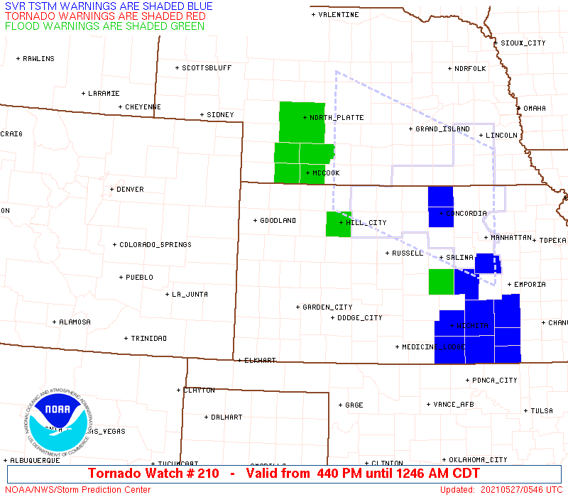
The Aviation Watch (SAW) product is an approximation to the watch area.
The actual watch is depicted by the shaded areas.
Note:
The Aviation Watch (SAW) product is an approximation to the watch area.
The actual watch is depicted by the shaded areas.
SAW0
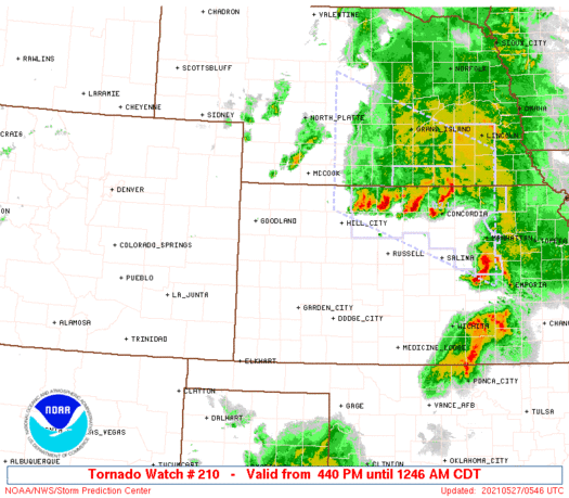
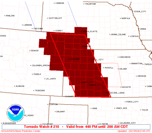
WW 210 TORNADO CO KS NE 262140Z - 270700Z
AXIS..75 STATUTE MILES EAST AND WEST OF LINE..
30NNW IML/IMPERIAL NE/ - 55SSE DDC/DODGE CITY KS/
..AVIATION COORDS.. 65NM E/W /52WSW LBF - 44NNE MMB/
HAIL SURFACE AND ALOFT..4 INCHES. WIND GUSTS..65 KNOTS.
MAX TOPS TO 600. MEAN STORM MOTION VECTOR 24025.
LAT...LON 40910040 37039823 37030095 40910328
THIS IS AN APPROXIMATION TO THE WATCH AREA. FOR A
COMPLETE DEPICTION OF THE WATCH SEE WOUS64 KWNS
FOR WOU0.
Watch 210 Status Report Messages:
STATUS REPORT #5 ON WW 210

VALID 270430Z - 270540Z

SEVERE WEATHER THREAT CONTINUES RIGHT OF A LINE FROM 15 E HLC TO
35 S MCK TO 10 NNW MCK TO 30 ENE MCK.

..KERR..05/27/21

ATTN...WFO...GLD...BOU...DDC...LBF...

&&

STATUS REPORT FOR WT 210

SEVERE WEATHER THREAT CONTINUES FOR THE FOLLOWING AREAS

KSC039-137-270540-

KS
.    KANSAS COUNTIES INCLUDED ARE

DECATUR 	     NORTON
$$


NEC145-270540-

NE
.    NEBRASKA COUNTIES INCLUDED ARE

RED WILLOW
$$


THE WATCH STATUS MESSAGE IS FOR GUIDANCE PURPOSES ONLY.  PLEASE
REFER TO WATCH COUNTY NOTIFICATION STATEMENTS FOR OFFICIAL
INFORMATION ON COUNTIES...INDEPENDENT CITIES AND MARINE ZONES
CLEARED FROM SEVERE THUNDERSTORM AND TORNADO WATCHES.
$$

STATUS REPORT #4 ON WW 210

VALID 270330Z - 270440Z

SEVERE WEATHER THREAT CONTINUES RIGHT OF A LINE FROM 30 NW AVK TO
35 NNW P28 TO 30 W RSL TO 30 WSW MCK TO 25 SE IML TO 30 SE LBF.

..KERR..05/27/21

ATTN...WFO...GLD...BOU...DDC...LBF...

&&

STATUS REPORT FOR WT 210

SEVERE WEATHER THREAT CONTINUES FOR THE FOLLOWING AREAS

KSC007-039-051-065-137-151-185-270440-

KS
.    KANSAS COUNTIES INCLUDED ARE

BARBER		     DECATUR		 ELLIS
GRAHAM		     NORTON		 PRATT
STAFFORD
$$


NEC063-085-087-145-270440-

NE
.    NEBRASKA COUNTIES INCLUDED ARE

FRONTIER	     HAYES		 HITCHCOCK
RED WILLOW
$$


THE WATCH STATUS MESSAGE IS FOR GUIDANCE PURPOSES ONLY.  PLEASE
REFER TO WATCH COUNTY NOTIFICATION STATEMENTS FOR OFFICIAL
INFORMATION ON COUNTIES...INDEPENDENT CITIES AND MARINE ZONES
CLEARED FROM SEVERE THUNDERSTORM AND TORNADO WATCHES.
$$

STATUS REPORT #3 ON WW 210

VALID 270225Z - 270340Z

SEVERE WEATHER THREAT CONTINUES RIGHT OF A LINE FROM 30 NNW ITR
TO 30 NNW IML.

..KERR..05/27/21

ATTN...WFO...GLD...BOU...DDC...LBF...

&&

STATUS REPORT FOR WT 210

SEVERE WEATHER THREAT CONTINUES FOR THE FOLLOWING AREAS

COC017-063-125-270340-

CO
.    COLORADO COUNTIES INCLUDED ARE

CHEYENNE	     KIT CARSON 	 YUMA
$$


KSC007-023-025-033-039-047-051-057-063-065-071-083-097-109-119-
135-137-145-151-153-165-179-181-185-193-195-199-203-270340-

KS
.    KANSAS COUNTIES INCLUDED ARE

BARBER		     CHEYENNE		 CLARK
COMANCHE	     DECATUR		 EDWARDS
ELLIS		     FORD		 GOVE
GRAHAM		     GREELEY		 HODGEMAN
KIOWA		     LOGAN		 MEADE
NESS		     NORTON		 PAWNEE
PRATT		     RAWLINS		 RUSH
SHERIDAN	     SHERMAN		 STAFFORD
THOMAS		     TREGO		 WALLACE
WICHITA
$$


NEC029-057-063-085-087-111-135-145-270340-

NE
.    NEBRASKA COUNTIES INCLUDED ARE

CHASE		     DUNDY		 FRONTIER
HAYES		     HITCHCOCK		 LINCOLN
PERKINS 	     RED WILLOW
$$


THE WATCH STATUS MESSAGE IS FOR GUIDANCE PURPOSES ONLY.  PLEASE
REFER TO WATCH COUNTY NOTIFICATION STATEMENTS FOR OFFICIAL
INFORMATION ON COUNTIES...INDEPENDENT CITIES AND MARINE ZONES
CLEARED FROM SEVERE THUNDERSTORM AND TORNADO WATCHES.
$$

STATUS REPORT #2 ON WW 210

VALID 270045Z - 270140Z

THE SEVERE WEATHER THREAT CONTINUES ACROSS THE ENTIRE WATCH AREA.

..KERR..05/27/21

ATTN...WFO...GLD...BOU...DDC...LBF...

&&

STATUS REPORT FOR WT 210

SEVERE WEATHER THREAT CONTINUES FOR THE FOLLOWING AREAS

COC017-063-075-087-095-115-121-125-270140-

CO
.    COLORADO COUNTIES INCLUDED ARE

CHEYENNE	     KIT CARSON 	 LOGAN
MORGAN		     PHILLIPS		 SEDGWICK
WASHINGTON	     YUMA
$$


KSC007-023-025-033-039-047-051-055-057-063-065-069-071-081-083-
093-097-101-109-119-135-137-145-151-153-165-171-175-179-181-185-
193-195-199-203-270140-

KS
.    KANSAS COUNTIES INCLUDED ARE

BARBER		     CHEYENNE		 CLARK
COMANCHE	     DECATUR		 EDWARDS
ELLIS		     FINNEY		 FORD
GOVE		     GRAHAM		 GRAY
GREELEY 	     HASKELL		 HODGEMAN
KEARNY		     KIOWA		 LANE
LOGAN		     MEADE		 NESS
NORTON		     PAWNEE		 PRATT
RAWLINS 	     RUSH		 SCOTT
SEWARD		     SHERIDAN		 SHERMAN
STAFFORD	     THOMAS		 TREGO
WALLACE 	     WICHITA
$$


NEC029-057-063-085-087-111-135-145-270140-

NE
.    NEBRASKA COUNTIES INCLUDED ARE

CHASE		     DUNDY		 FRONTIER
HAYES		     HITCHCOCK		 LINCOLN
PERKINS 	     RED WILLOW
$$


THE WATCH STATUS MESSAGE IS FOR GUIDANCE PURPOSES ONLY.  PLEASE
REFER TO WATCH COUNTY NOTIFICATION STATEMENTS FOR OFFICIAL
INFORMATION ON COUNTIES...INDEPENDENT CITIES AND MARINE ZONES
CLEARED FROM SEVERE THUNDERSTORM AND TORNADO WATCHES.
$$

STATUS REPORT #1 ON WW 210

VALID 262325Z - 270040Z

THE SEVERE WEATHER THREAT CONTINUES ACROSS THE ENTIRE WATCH AREA.

..KERR..05/26/21

ATTN...WFO...GLD...BOU...DDC...LBF...

&&

STATUS REPORT FOR WT 210

SEVERE WEATHER THREAT CONTINUES FOR THE FOLLOWING AREAS

COC017-063-075-087-095-115-121-125-270040-

CO
.    COLORADO COUNTIES INCLUDED ARE

CHEYENNE	     KIT CARSON 	 LOGAN
MORGAN		     PHILLIPS		 SEDGWICK
WASHINGTON	     YUMA
$$


KSC007-023-025-033-039-047-051-055-057-063-065-069-071-081-083-
093-097-101-109-119-135-137-145-151-153-165-171-175-179-181-185-
193-195-199-203-270040-

KS
.    KANSAS COUNTIES INCLUDED ARE

BARBER		     CHEYENNE		 CLARK
COMANCHE	     DECATUR		 EDWARDS
ELLIS		     FINNEY		 FORD
GOVE		     GRAHAM		 GRAY
GREELEY 	     HASKELL		 HODGEMAN
KEARNY		     KIOWA		 LANE
LOGAN		     MEADE		 NESS
NORTON		     PAWNEE		 PRATT
RAWLINS 	     RUSH		 SCOTT
SEWARD		     SHERIDAN		 SHERMAN
STAFFORD	     THOMAS		 TREGO
WALLACE 	     WICHITA
$$


NEC029-057-063-085-087-111-135-145-270040-

NE
.    NEBRASKA COUNTIES INCLUDED ARE

CHASE		     DUNDY		 FRONTIER
HAYES		     HITCHCOCK		 LINCOLN
PERKINS 	     RED WILLOW
$$


THE WATCH STATUS MESSAGE IS FOR GUIDANCE PURPOSES ONLY.  PLEASE
REFER TO WATCH COUNTY NOTIFICATION STATEMENTS FOR OFFICIAL
INFORMATION ON COUNTIES...INDEPENDENT CITIES AND MARINE ZONES
CLEARED FROM SEVERE THUNDERSTORM AND TORNADO WATCHES.
$$
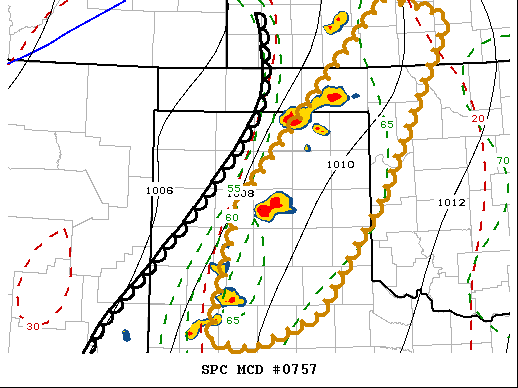
Note:
Click for Complete Product Text.
Tornadoes
Probability of 2 or more tornadoes
|
High (80%)
|
Probability of 1 or more strong (EF2-EF5) tornadoes
|
High (80%)
|
Wind
Probability of 10 or more severe wind events
|
Mod (60%)
|
Probability of 1 or more wind events > 65 knots
|
Mod (60%)
|
Hail
Probability of 10 or more severe hail events
|
High (80%)
|
Probability of 1 or more hailstones > 2 inches
|
High (80%)
|
Combined Severe Hail/Wind
Probability of 6 or more combined severe hail/wind events
|
High (>95%)
|
For each watch, probabilities for particular events inside the watch
(listed above in each table) are determined by the issuing forecaster.
The "Low" category contains probability values ranging from less than 2%
to 20% (EF2-EF5 tornadoes), less than 5% to 20% (all other probabilities),
"Moderate" from 30% to 60%, and "High" from 70% to greater than 95%.
High values are bolded and lighter in color to provide awareness of
an increased threat for a particular event.


 @NWSSPC