 Note:
The expiration time in the watch graphic is amended if the watch is
replaced, cancelled or extended.
Note:
Note:
The expiration time in the watch graphic is amended if the watch is
replaced, cancelled or extended.
Note: Click for
Watch Status Reports.
SEL2
URGENT - IMMEDIATE BROADCAST REQUESTED
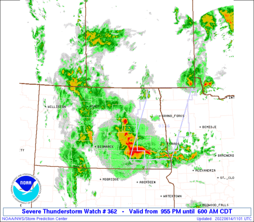
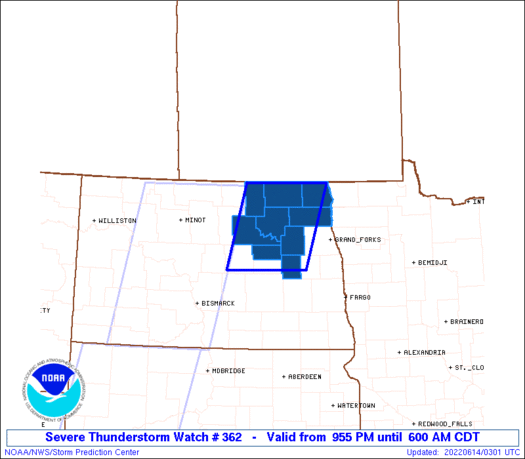
Severe Thunderstorm Watch Number 362
NWS Storm Prediction Center Norman OK
955 PM CDT Mon Jun 13 2022
The NWS Storm Prediction Center has issued a
* Severe Thunderstorm Watch for portions of
Northeast North Dakota
* Effective this Monday night and Tuesday morning from 955 PM
until 600 AM CDT.
* Primary threats include...
Scattered damaging wind gusts to 70 mph possible
Scattered large hail events to 1.5 inches in diameter possible
SUMMARY...A line of strong-severe storms in north central North
Dakota may persist into northeast North Dakota overnight. The
strongest embedded storms will be capable of producing severe
outflow winds of 60-70 mph and large hail up to 1.5 inches in
diameter. Additional storms could move into parts of eastern North
Dakota during the early morning hours.
The severe thunderstorm watch area is approximately along and 50
statute miles east and west of a line from 65 miles north northeast
of Devils Lake ND to 50 miles south of Devils Lake ND. For a
complete depiction of the watch see the associated watch outline
update (WOUS64 KWNS WOU2).
PRECAUTIONARY/PREPAREDNESS ACTIONS...
REMEMBER...A Severe Thunderstorm Watch means conditions are
favorable for severe thunderstorms in and close to the watch area.
Persons in these areas should be on the lookout for threatening
weather conditions and listen for later statements and possible
warnings. Severe thunderstorms can and occasionally do produce
tornadoes.
&&
OTHER WATCH INFORMATION...CONTINUE...WW 356...WW 358...WW
359...WW 360...WW 361...
AVIATION...A few severe thunderstorms with hail surface and aloft to
1.5 inches. Extreme turbulence and surface wind gusts to 60 knots. A
few cumulonimbi with maximum tops to 500. Mean storm motion vector
25035.
...Thompson
 Note:
The Aviation Watch (SAW) product is an approximation to the watch area.
The actual watch is depicted by the shaded areas.
Note:
The Aviation Watch (SAW) product is an approximation to the watch area.
The actual watch is depicted by the shaded areas.
   SAW2
   WW 362 SEVERE TSTM ND 140255Z - 141100Z
   AXIS..50 STATUTE MILES EAST AND WEST OF LINE..
   65NNE DVL/DEVILS LAKE ND/ - 50S DVL/DEVILS LAKE ND/
   ..AVIATION COORDS.. 45NM E/W /71SW YWG - 77WSW GFK/
   HAIL SURFACE AND ALOFT..1.5 INCHES. WIND GUSTS..60 KNOTS.
   MAX TOPS TO 500. MEAN STORM MOTION VECTOR 25035.

   LAT...LON 48989727 47399785 47399999 48989947

   THIS IS AN APPROXIMATION TO THE WATCH AREA.  FOR A
   COMPLETE DEPICTION OF THE WATCH SEE WOUS64 KWNS
   FOR WOU2.
Watch 362 Status Report Messages:
STATUS REPORT #5 ON WW 362

VALID 141040Z - 141100Z

THE SEVERE WEATHER THREAT CONTINUES ACROSS THE ENTIRE WATCH AREA.

WW 362 WILL BE ALLOWED TO EXPIRE AT 141100Z.

..DEAN..06/14/22

ATTN...WFO...FGF...

&&

STATUS REPORT FOR WS 362

SEVERE WEATHER THREAT CONTINUES FOR THE FOLLOWING AREAS

NDC005-019-027-039-063-067-071-095-099-141100-

ND
.    NORTH DAKOTA COUNTIES INCLUDED ARE

BENSON		     CAVALIER		 EDDY
GRIGGS		     NELSON		 PEMBINA
RAMSEY		     TOWNER		 WALSH
$$


THE WATCH STATUS MESSAGE IS FOR GUIDANCE PURPOSES ONLY.  PLEASE
REFER TO WATCH COUNTY NOTIFICATION STATEMENTS FOR OFFICIAL
INFORMATION ON COUNTIES...INDEPENDENT CITIES AND MARINE ZONES
CLEARED FROM SEVERE THUNDERSTORM AND TORNADO WATCHES.
$$

STATUS REPORT #4 ON WW 362

VALID 140830Z - 140940Z

THE SEVERE WEATHER THREAT CONTINUES ACROSS THE ENTIRE WATCH AREA.

..DEAN..06/14/22

ATTN...WFO...FGF...

&&

STATUS REPORT FOR WS 362

SEVERE WEATHER THREAT CONTINUES FOR THE FOLLOWING AREAS

NDC005-019-027-039-063-067-071-095-099-140940-

ND
.    NORTH DAKOTA COUNTIES INCLUDED ARE

BENSON		     CAVALIER		 EDDY
GRIGGS		     NELSON		 PEMBINA
RAMSEY		     TOWNER		 WALSH
$$


THE WATCH STATUS MESSAGE IS FOR GUIDANCE PURPOSES ONLY.  PLEASE
REFER TO WATCH COUNTY NOTIFICATION STATEMENTS FOR OFFICIAL
INFORMATION ON COUNTIES...INDEPENDENT CITIES AND MARINE ZONES
CLEARED FROM SEVERE THUNDERSTORM AND TORNADO WATCHES.
$$

STATUS REPORT #3 ON WW 362

VALID 140700Z - 140840Z

THE SEVERE WEATHER THREAT CONTINUES ACROSS THE ENTIRE WATCH AREA.

..DEAN..06/14/22

ATTN...WFO...FGF...

&&

STATUS REPORT FOR WS 362

SEVERE WEATHER THREAT CONTINUES FOR THE FOLLOWING AREAS

NDC005-019-027-039-063-067-071-095-099-140840-

ND
.    NORTH DAKOTA COUNTIES INCLUDED ARE

BENSON		     CAVALIER		 EDDY
GRIGGS		     NELSON		 PEMBINA
RAMSEY		     TOWNER		 WALSH
$$


THE WATCH STATUS MESSAGE IS FOR GUIDANCE PURPOSES ONLY.  PLEASE
REFER TO WATCH COUNTY NOTIFICATION STATEMENTS FOR OFFICIAL
INFORMATION ON COUNTIES...INDEPENDENT CITIES AND MARINE ZONES
CLEARED FROM SEVERE THUNDERSTORM AND TORNADO WATCHES.
$$

STATUS REPORT #2 ON WW 362

VALID 140545Z - 140640Z

THE SEVERE WEATHER THREAT CONTINUES ACROSS THE ENTIRE WATCH AREA.

..DEAN..06/14/22

ATTN...WFO...FGF...

&&

STATUS REPORT FOR WS 362

SEVERE WEATHER THREAT CONTINUES FOR THE FOLLOWING AREAS

NDC005-019-027-039-063-067-071-095-099-140640-

ND
.    NORTH DAKOTA COUNTIES INCLUDED ARE

BENSON		     CAVALIER		 EDDY
GRIGGS		     NELSON		 PEMBINA
RAMSEY		     TOWNER		 WALSH
$$


THE WATCH STATUS MESSAGE IS FOR GUIDANCE PURPOSES ONLY.  PLEASE
REFER TO WATCH COUNTY NOTIFICATION STATEMENTS FOR OFFICIAL
INFORMATION ON COUNTIES...INDEPENDENT CITIES AND MARINE ZONES
CLEARED FROM SEVERE THUNDERSTORM AND TORNADO WATCHES.
$$

STATUS REPORT #1 ON WW 362

VALID 140440Z - 140540Z

THE SEVERE WEATHER THREAT CONTINUES ACROSS THE ENTIRE WATCH AREA.

..SPC..06/14/22

ATTN...WFO...FGF...

&&

STATUS REPORT FOR WS 362

SEVERE WEATHER THREAT CONTINUES FOR THE FOLLOWING AREAS

NDC005-019-027-039-063-067-071-095-099-140540-

ND
.    NORTH DAKOTA COUNTIES INCLUDED ARE

BENSON		     CAVALIER		 EDDY
GRIGGS		     NELSON		 PEMBINA
RAMSEY		     TOWNER		 WALSH
$$


THE WATCH STATUS MESSAGE IS FOR GUIDANCE PURPOSES ONLY.  PLEASE
REFER TO WATCH COUNTY NOTIFICATION STATEMENTS FOR OFFICIAL
INFORMATION ON COUNTIES...INDEPENDENT CITIES AND MARINE ZONES
CLEARED FROM SEVERE THUNDERSTORM AND TORNADO WATCHES.
$$
Note:
Click for Complete Product Text.
Tornadoes
Probability of 2 or more tornadoes
|
Low (10%)
|
Probability of 1 or more strong (EF2-EF5) tornadoes
|
Low (5%)
|
Wind
Probability of 10 or more severe wind events
|
Mod (40%)
|
Probability of 1 or more wind events > 65 knots
|
Low (20%)
|
Hail
Probability of 10 or more severe hail events
|
Mod (40%)
|
Probability of 1 or more hailstones > 2 inches
|
Low (20%)
|
Combined Severe Hail/Wind
Probability of 6 or more combined severe hail/wind events
|
High (70%)
|
For each watch, probabilities for particular events inside the watch
(listed above in each table) are determined by the issuing forecaster.
The "Low" category contains probability values ranging from less than 2%
to 20% (EF2-EF5 tornadoes), less than 5% to 20% (all other probabilities),
"Moderate" from 30% to 60%, and "High" from 70% to greater than 95%.
High values are bolded and lighter in color to provide awareness of
an increased threat for a particular event.


 @NWSSPC


