 Note:
The expiration time in the watch graphic is amended if the watch is
replaced, cancelled or extended.
Note:
Note:
The expiration time in the watch graphic is amended if the watch is
replaced, cancelled or extended.
Note: Click for
Watch Status Reports.
SEL4
URGENT - IMMEDIATE BROADCAST REQUESTED
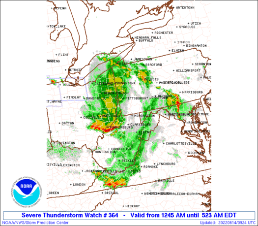
Severe Thunderstorm Watch Number 364
NWS Storm Prediction Center Norman OK
1245 AM EDT Tue Jun 14 2022
The NWS Storm Prediction Center has issued a
* Severe Thunderstorm Watch for portions of
The western Maryland Panhandle
Extreme southeast Ohio
Southwestern Pennsylvania
Northern West Virginia
* Effective this Tuesday morning from 1245 AM until 600 AM EDT.
* Primary threats include...
Scattered damaging wind gusts to 70 mph likely
Isolated large hail events to 1 inch in diameter possible
SUMMARY...A well-developed squall line with bowing characteristics
will likely persist for a few more hours in a zone north of prior
convection across West Virginia. Damaging winds up to 70 mph will
be the main threat, though isolated large hail may also occur for
the strongest embedded updrafts.
The severe thunderstorm watch area is approximately along and 50
statute miles north and south of a line from 35 miles southwest of
Pittsburgh PA to 60 miles southeast of Latrobe PA. For a complete
depiction of the watch see the associated watch outline update
(WOUS64 KWNS WOU4).
PRECAUTIONARY/PREPAREDNESS ACTIONS...
REMEMBER...A Severe Thunderstorm Watch means conditions are
favorable for severe thunderstorms in and close to the watch area.
Persons in these areas should be on the lookout for threatening
weather conditions and listen for later statements and possible
warnings. Severe thunderstorms can and occasionally do produce
tornadoes.
&&
OTHER WATCH INFORMATION...CONTINUE...WW 358...WW 360...WW
361...WW 362...WW 363...
AVIATION...A few severe thunderstorms with hail surface and aloft to
1 inch. Extreme turbulence and surface wind gusts to 60 knots. A few
cumulonimbi with maximum tops to 500. Mean storm motion vector
30045.
...Thompson
   SEL4

   URGENT - IMMEDIATE BROADCAST REQUESTED
   Severe Thunderstorm Watch Number 364
   NWS Storm Prediction Center Norman OK
   1245 AM EDT Tue Jun 14 2022

   The NWS Storm Prediction Center has issued a

   * Severe Thunderstorm Watch for portions of
     The western Maryland Panhandle
     Extreme southeast Ohio
     Southwestern Pennsylvania
     Northern West Virginia

   * Effective this Tuesday morning from 1245 AM until 600 AM EDT.

   * Primary threats include...
     Scattered damaging wind gusts to 70 mph likely
     Isolated large hail events to 1 inch in diameter possible

   SUMMARY...A well-developed squall line with bowing characteristics
   will likely persist for a few more hours in a zone north of prior
   convection across West Virginia.  Damaging winds up to 70 mph will
   be the main threat, though isolated large hail may also occur for
   the strongest embedded updrafts.

   The severe thunderstorm watch area is approximately along and 50
   statute miles north and south of a line from 35 miles southwest of
   Pittsburgh PA to 60 miles southeast of Latrobe PA. For a complete
   depiction of the watch see the associated watch outline update
   (WOUS64 KWNS WOU4).

   PRECAUTIONARY/PREPAREDNESS ACTIONS...

   REMEMBER...A Severe Thunderstorm Watch means conditions are
   favorable for severe thunderstorms in and close to the watch area.
   Persons in these areas should be on the lookout for threatening
   weather conditions and listen for later statements and possible
   warnings. Severe thunderstorms can and occasionally do produce
   tornadoes.

   &&

   OTHER WATCH INFORMATION...CONTINUE...WW 358...WW 360...WW
   361...WW 362...WW 363...

   AVIATION...A few severe thunderstorms with hail surface and aloft to
   1 inch. Extreme turbulence and surface wind gusts to 60 knots. A few
   cumulonimbi with maximum tops to 500. Mean storm motion vector
   30045.

   ...Thompson
 Note:
The Aviation Watch (SAW) product is an approximation to the watch area.
The actual watch is depicted by the shaded areas.
Note:
The Aviation Watch (SAW) product is an approximation to the watch area.
The actual watch is depicted by the shaded areas.
SAW4
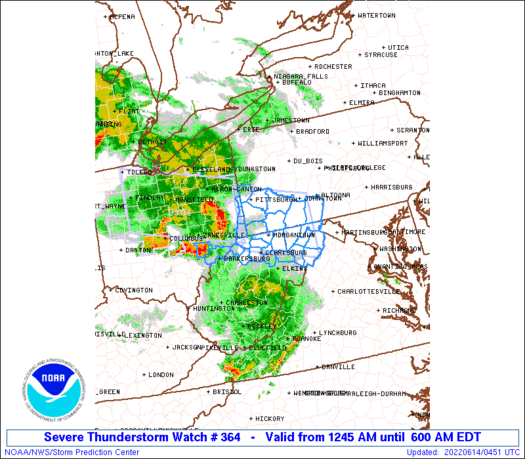
WW 364 SEVERE TSTM MD OH PA WV 140445Z - 141000Z
AXIS..50 STATUTE MILES NORTH AND SOUTH OF LINE..
35SW PIT/PITTSBURGH PA/ - 60SE LBE/LATROBE PA/
..AVIATION COORDS.. 45NM N/S /9NE AIR - 41SSE JST/
HAIL SURFACE AND ALOFT..1 INCH. WIND GUSTS..60 KNOTS.
MAX TOPS TO 500. MEAN STORM MOTION VECTOR 30045.
LAT...LON 40868069 40397860 38937860 39418069
THIS IS AN APPROXIMATION TO THE WATCH AREA. FOR A
COMPLETE DEPICTION OF THE WATCH SEE WOUS64 KWNS
FOR WOU4.
Watch 364 Status Report Messages:
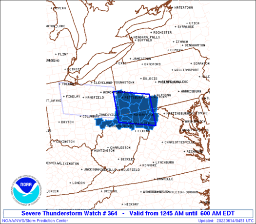
STATUS REPORT #2 ON WW 364

VALID 140710Z - 140840Z

SEVERE WEATHER THREAT CONTINUES RIGHT OF A LINE FROM 20 WNW MRB
TO 30 N LBE.

..DEAN..06/14/22

ATTN...WFO...LWX...RLX...PBZ...CTP...

&&

STATUS REPORT FOR WS 364

SEVERE WEATHER THREAT CONTINUES FOR THE FOLLOWING AREAS

PAC009-111-140840-

PA
.    PENNSYLVANIA COUNTIES INCLUDED ARE

BEDFORD 	     SOMERSET
$$


THE WATCH STATUS MESSAGE IS FOR GUIDANCE PURPOSES ONLY.  PLEASE
REFER TO WATCH COUNTY NOTIFICATION STATEMENTS FOR OFFICIAL
INFORMATION ON COUNTIES...INDEPENDENT CITIES AND MARINE ZONES
CLEARED FROM SEVERE THUNDERSTORM AND TORNADO WATCHES.
$$

STATUS REPORT #1 ON WW 364

VALID 140555Z - 140640Z

THE SEVERE WEATHER THREAT CONTINUES ACROSS THE ENTIRE WATCH AREA.

..DEAN..06/14/22

ATTN...WFO...LWX...RLX...PBZ...CTP...

&&

STATUS REPORT FOR WS 364

SEVERE WEATHER THREAT CONTINUES FOR THE FOLLOWING AREAS

MDC001-023-140640-

MD
.    MARYLAND COUNTIES INCLUDED ARE

ALLEGANY	     GARRETT
$$


OHC115-167-140640-

OH
.    OHIO COUNTIES INCLUDED ARE

MORGAN		     WASHINGTON
$$


PAC003-007-009-051-059-111-125-129-140640-

PA
.    PENNSYLVANIA COUNTIES INCLUDED ARE

ALLEGHENY	     BEAVER		 BEDFORD
FAYETTE 	     GREENE		 SOMERSET
WASHINGTON	     WESTMORELAND
$$


WVC001-009-017-023-027-029-031-033-049-051-057-061-069-073-077-
091-093-095-103-140640-

WV
.    WEST VIRGINIA COUNTIES INCLUDED ARE

BARBOUR 	     BROOKE		 DODDRIDGE
GRANT		     HAMPSHIRE		 HANCOCK
HARDY		     HARRISON		 MARION
MARSHALL	     MINERAL		 MONONGALIA
OHIO		     PLEASANTS		 PRESTON
TAYLOR		     TUCKER		 TYLER
WETZEL
$$


THE WATCH STATUS MESSAGE IS FOR GUIDANCE PURPOSES ONLY.  PLEASE
REFER TO WATCH COUNTY NOTIFICATION STATEMENTS FOR OFFICIAL
INFORMATION ON COUNTIES...INDEPENDENT CITIES AND MARINE ZONES
CLEARED FROM SEVERE THUNDERSTORM AND TORNADO WATCHES.
$$
Note:
Click for Complete Product Text.
Tornadoes
Probability of 2 or more tornadoes
|
Low (10%)
|
Probability of 1 or more strong (EF2-EF5) tornadoes
|
Low (5%)
|
Wind
Probability of 10 or more severe wind events
|
Mod (60%)
|
Probability of 1 or more wind events > 65 knots
|
Low (10%)
|
Hail
Probability of 10 or more severe hail events
|
Mod (30%)
|
Probability of 1 or more hailstones > 2 inches
|
Low (<5%)
|
Combined Severe Hail/Wind
Probability of 6 or more combined severe hail/wind events
|
High (80%)
|
For each watch, probabilities for particular events inside the watch
(listed above in each table) are determined by the issuing forecaster.
The "Low" category contains probability values ranging from less than 2%
to 20% (EF2-EF5 tornadoes), less than 5% to 20% (all other probabilities),
"Moderate" from 30% to 60%, and "High" from 70% to greater than 95%.
High values are bolded and lighter in color to provide awareness of
an increased threat for a particular event.


 @NWSSPC


