 Note:
The expiration time in the watch graphic is amended if the watch is
replaced, cancelled or extended.
Note:
Note:
The expiration time in the watch graphic is amended if the watch is
replaced, cancelled or extended.
Note: Click for
Watch Status Reports.
SEL8
URGENT - IMMEDIATE BROADCAST REQUESTED
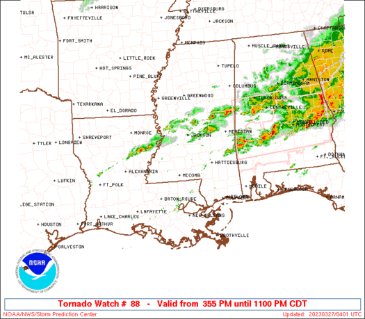
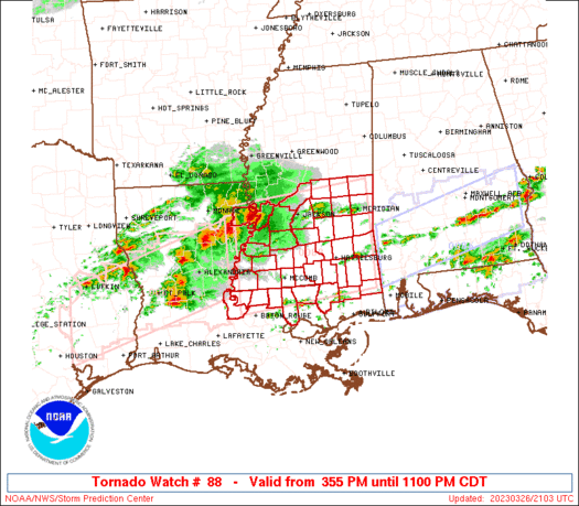
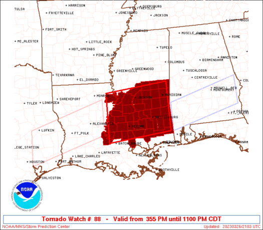
Tornado Watch Number 88
NWS Storm Prediction Center Norman OK
355 PM CDT Sun Mar 26 2023
The NWS Storm Prediction Center has issued a
* Tornado Watch for portions of
Far Eastern Louisiana
Southern and Central Mississippi
* Effective this Sunday afternoon and evening from 355 PM until
1100 PM CDT.
* Primary threats include...
Several tornadoes and a couple intense tornadoes likely
Scattered large hail likely with isolated very large hail events
to 3 inches in diameter possible
Scattered damaging wind gusts to 70 mph likely
SUMMARY...Supercell storms are expected to develop across and move
into southern and parts of central Mississippi this evening. Large
hail and damaging winds will be the main threats initially, but the
tornado potential should increase toward and after sunset, when
low-level shear will considerably increase. This includes the
potential for long-lived supercells and strong tornadoes (EF2+).
The tornado watch area is approximately along and 70 statute miles
north and south of a line from 10 miles west southwest of Natchez MS
to 35 miles south southeast of Meridian MS. For a complete depiction
of the watch see the associated watch outline update (WOUS64 KWNS
WOU8).
PRECAUTIONARY/PREPAREDNESS ACTIONS...
REMEMBER...A Tornado Watch means conditions are favorable for
tornadoes and severe thunderstorms in and close to the watch
area. Persons in these areas should be on the lookout for
threatening weather conditions and listen for later statements
and possible warnings.
&&
OTHER WATCH INFORMATION...CONTINUE...WW 86...WW 87...
AVIATION...Tornadoes and a few severe thunderstorms with hail
surface and aloft to 3 inches. Extreme turbulence and surface wind
gusts to 60 knots. A few cumulonimbi with maximum tops to 600. Mean
storm motion vector 26030.
...Guyer
   SEL8

   URGENT - IMMEDIATE BROADCAST REQUESTED
   Tornado Watch Number 88
   NWS Storm Prediction Center Norman OK
   355 PM CDT Sun Mar 26 2023

   The NWS Storm Prediction Center has issued a

   * Tornado Watch for portions of
     Far Eastern Louisiana
     Southern and Central Mississippi

   * Effective this Sunday afternoon and evening from 355 PM until
     1100 PM CDT.

   * Primary threats include...
     Several tornadoes and a couple intense tornadoes likely
     Scattered large hail likely with isolated very large hail events
       to 3 inches in diameter possible
     Scattered damaging wind gusts to 70 mph likely

   SUMMARY...Supercell storms are expected to develop across and move
   into southern and parts of central Mississippi this evening. Large
   hail and damaging winds will be the main threats initially, but the
   tornado potential should increase toward and after sunset, when
   low-level shear will considerably increase. This includes the
   potential for long-lived supercells and strong tornadoes (EF2+).

   The tornado watch area is approximately along and 70 statute miles
   north and south of a line from 10 miles west southwest of Natchez MS
   to 35 miles south southeast of Meridian MS. For a complete depiction
   of the watch see the associated watch outline update (WOUS64 KWNS
   WOU8).

   PRECAUTIONARY/PREPAREDNESS ACTIONS...

   REMEMBER...A Tornado Watch means conditions are favorable for
   tornadoes and severe thunderstorms in and close to the watch
   area. Persons in these areas should be on the lookout for
   threatening weather conditions and listen for later statements
   and possible warnings.

   &&

   OTHER WATCH INFORMATION...CONTINUE...WW 86...WW 87...

   AVIATION...Tornadoes and a few severe thunderstorms with hail
   surface and aloft to 3 inches. Extreme turbulence and surface wind
   gusts to 60 knots. A few cumulonimbi with maximum tops to 600. Mean
   storm motion vector 26030.

   ...Guyer
 Note:
The Aviation Watch (SAW) product is an approximation to the watch area.
The actual watch is depicted by the shaded areas.
Note:
The Aviation Watch (SAW) product is an approximation to the watch area.
The actual watch is depicted by the shaded areas.
   SAW8
   WW 88 TORNADO LA MS 262055Z - 270400Z
   AXIS..70 STATUTE MILES NORTH AND SOUTH OF LINE..
   10WSW HEZ/NATCHEZ MS/ - 35SSE MEI/MERIDIAN MS/
   ..AVIATION COORDS.. 60NM N/S /56ENE AEX - 34SSE MEI/
   HAIL SURFACE AND ALOFT..3 INCHES. WIND GUSTS..60 KNOTS.
   MAX TOPS TO 600. MEAN STORM MOTION VECTOR 26030.

   LAT...LON 32589146 32878852 30858852 30559146

   THIS IS AN APPROXIMATION TO THE WATCH AREA.  FOR A
   COMPLETE DEPICTION OF THE WATCH SEE WOUS64 KWNS
   FOR WOU8.
Watch 88 Status Report Messages:
STATUS REPORT #7 ON WW 88

VALID 270325Z - 270400Z

SEVERE WEATHER THREAT CONTINUES RIGHT OF A LINE FROM 45 E PIB TO
35 NE MCB TO 60 W MEI TO 20 E MEI.

REMAINING VALID PORTION OF WW 88 MAY BE ALLOWED TO EXPIRE AT
27/04Z.
..KERR..03/27/23

ATTN...WFO...LIX...JAN...MOB...

&&

STATUS REPORT FOR WT 88

SEVERE WEATHER THREAT CONTINUES FOR THE FOLLOWING AREAS

MSC023-061-075-101-121-123-127-129-153-270400-

MS
.    MISSISSIPPI COUNTIES INCLUDED ARE

CLARKE		     JASPER		 LAUDERDALE
NEWTON		     RANKIN		 SCOTT
SIMPSON 	     SMITH		 WAYNE
$$


THE WATCH STATUS MESSAGE IS FOR GUIDANCE PURPOSES ONLY.  PLEASE
REFER TO WATCH COUNTY NOTIFICATION STATEMENTS FOR OFFICIAL
INFORMATION ON COUNTIES...INDEPENDENT CITIES AND MARINE ZONES
CLEARED FROM SEVERE THUNDERSTORM AND TORNADO WATCHES.
$$

STATUS REPORT #6 ON WW 88

VALID 270230Z - 270340Z

SEVERE WEATHER THREAT CONTINUES RIGHT OF A LINE FROM 50 E PIB TO
40 W PIB TO 65 NNW PIB TO 20 E MEI.

..KERR..03/27/23

ATTN...WFO...LIX...JAN...MOB...

&&

STATUS REPORT FOR WT 88

SEVERE WEATHER THREAT CONTINUES FOR THE FOLLOWING AREAS

MSC023-031-061-065-067-075-101-121-123-127-129-153-270340-

MS
.    MISSISSIPPI COUNTIES INCLUDED ARE

CLARKE		     COVINGTON		 JASPER
JEFFERSON DAVIS      JONES		 LAUDERDALE
NEWTON		     RANKIN		 SCOTT
SIMPSON 	     SMITH		 WAYNE
$$


THE WATCH STATUS MESSAGE IS FOR GUIDANCE PURPOSES ONLY.  PLEASE
REFER TO WATCH COUNTY NOTIFICATION STATEMENTS FOR OFFICIAL
INFORMATION ON COUNTIES...INDEPENDENT CITIES AND MARINE ZONES
CLEARED FROM SEVERE THUNDERSTORM AND TORNADO WATCHES.
$$

STATUS REPORT #5 ON WW 88

VALID 270145Z - 270240Z

SEVERE WEATHER THREAT CONTINUES RIGHT OF A LINE FROM 35 NW ASD TO
35 NE MCB TO 35 N MCB TO 70 NW PIB TO 55 W MEI TO 30 NE MEI.

..KERR..03/27/23

ATTN...WFO...LIX...JAN...MOB...

&&

STATUS REPORT FOR WT 88

SEVERE WEATHER THREAT CONTINUES FOR THE FOLLOWING AREAS

MSC023-029-031-035-039-041-061-065-067-073-075-077-091-101-111-
121-123-127-129-131-147-153-270240-

MS
.    MISSISSIPPI COUNTIES INCLUDED ARE

CLARKE		     COPIAH		 COVINGTON
FORREST 	     GEORGE		 GREENE
JASPER		     JEFFERSON DAVIS	 JONES
LAMAR		     LAUDERDALE 	 LAWRENCE
MARION		     NEWTON		 PERRY
RANKIN		     SCOTT		 SIMPSON
SMITH		     STONE		 WALTHALL
WAYNE
$$


THE WATCH STATUS MESSAGE IS FOR GUIDANCE PURPOSES ONLY.  PLEASE
REFER TO WATCH COUNTY NOTIFICATION STATEMENTS FOR OFFICIAL
INFORMATION ON COUNTIES...INDEPENDENT CITIES AND MARINE ZONES
CLEARED FROM SEVERE THUNDERSTORM AND TORNADO WATCHES.
$$

STATUS REPORT #4 ON WW 88

VALID 270035Z - 270140Z

THE SEVERE WEATHER THREAT CONTINUES ACROSS THE ENTIRE WATCH AREA.

FOR ADDITIONAL INFORMATION SEE MESOSCALE DISCUSSION 364

..THORNTON..03/27/23

ATTN...WFO...LIX...JAN...MOB...

&&

STATUS REPORT FOR WT 88

SEVERE WEATHER THREAT CONTINUES FOR THE FOLLOWING AREAS

LAC025-029-037-041-065-077-091-105-107-117-125-270140-

LA
.    LOUISIANA PARISHES INCLUDED ARE

CATAHOULA	     CONCORDIA		 EAST FELICIANA
FRANKLIN	     MADISON		 POINTE COUPEE
ST. HELENA	     TANGIPAHOA 	 TENSAS
WASHINGTON	     WEST FELICIANA
$$


MSC001-005-021-023-029-031-035-037-039-041-049-061-063-065-067-
069-073-075-077-079-085-089-091-099-101-109-111-113-121-123-127-
129-131-147-149-153-157-270140-

MS
.    MISSISSIPPI COUNTIES INCLUDED ARE

ADAMS		     AMITE		 CLAIBORNE
CLARKE		     COPIAH		 COVINGTON
FORREST 	     FRANKLIN		 GEORGE
GREENE		     HINDS		 JASPER
JEFFERSON	     JEFFERSON DAVIS	 JONES
KEMPER		     LAMAR		 LAUDERDALE
LAWRENCE	     LEAKE		 LINCOLN
MADISON 	     MARION		 NESHOBA
NEWTON		     PEARL RIVER	 PERRY
PIKE		     RANKIN		 SCOTT
SIMPSON 	     SMITH		 STONE
WALTHALL	     WARREN		 WAYNE
WILKINSON
$$


THE WATCH STATUS MESSAGE IS FOR GUIDANCE PURPOSES ONLY.  PLEASE
REFER TO WATCH COUNTY NOTIFICATION STATEMENTS FOR OFFICIAL
INFORMATION ON COUNTIES...INDEPENDENT CITIES AND MARINE ZONES
CLEARED FROM SEVERE THUNDERSTORM AND TORNADO WATCHES.
$$

STATUS REPORT #3 ON WW 88

VALID 262335Z - 270040Z

THE SEVERE WEATHER THREAT CONTINUES ACROSS THE ENTIRE WATCH AREA.

..THORNTON..03/26/23

ATTN...WFO...LIX...JAN...MOB...

&&

STATUS REPORT FOR WT 88

SEVERE WEATHER THREAT CONTINUES FOR THE FOLLOWING AREAS

LAC037-065-077-091-105-117-125-270040-

LA
.    LOUISIANA PARISHES INCLUDED ARE

EAST FELICIANA	     MADISON		 POINTE COUPEE
ST. HELENA	     TANGIPAHOA 	 WASHINGTON
WEST FELICIANA
$$


MSC001-005-021-023-029-031-035-037-039-041-049-061-063-065-067-
069-073-075-077-079-085-089-091-099-101-109-111-113-121-123-127-
129-131-147-149-153-157-270040-

MS
.    MISSISSIPPI COUNTIES INCLUDED ARE

ADAMS		     AMITE		 CLAIBORNE
CLARKE		     COPIAH		 COVINGTON
FORREST 	     FRANKLIN		 GEORGE
GREENE		     HINDS		 JASPER
JEFFERSON	     JEFFERSON DAVIS	 JONES
KEMPER		     LAMAR		 LAUDERDALE
LAWRENCE	     LEAKE		 LINCOLN
MADISON 	     MARION		 NESHOBA
NEWTON		     PEARL RIVER	 PERRY
PIKE		     RANKIN		 SCOTT
SIMPSON 	     SMITH		 STONE
WALTHALL	     WARREN		 WAYNE
WILKINSON
$$


THE WATCH STATUS MESSAGE IS FOR GUIDANCE PURPOSES ONLY.  PLEASE
REFER TO WATCH COUNTY NOTIFICATION STATEMENTS FOR OFFICIAL
INFORMATION ON COUNTIES...INDEPENDENT CITIES AND MARINE ZONES
CLEARED FROM SEVERE THUNDERSTORM AND TORNADO WATCHES.
$$

STATUS REPORT #2 ON WW 88

VALID 262245Z - 262340Z

THE SEVERE WEATHER THREAT CONTINUES ACROSS THE ENTIRE WATCH AREA.

FOR ADDITIONAL INFORMATION SEE MESOSCALE DISCUSSION 361

..THORNTON..03/26/23

ATTN...WFO...LIX...JAN...MOB...

&&

STATUS REPORT FOR WT 88

SEVERE WEATHER THREAT CONTINUES FOR THE FOLLOWING AREAS

LAC037-065-077-091-105-117-125-262340-

LA
.    LOUISIANA PARISHES INCLUDED ARE

EAST FELICIANA	     MADISON		 POINTE COUPEE
ST. HELENA	     TANGIPAHOA 	 WASHINGTON
WEST FELICIANA
$$


MSC001-005-021-023-029-031-035-037-039-041-049-061-063-065-067-
069-073-075-077-079-085-089-091-099-101-109-111-113-121-123-127-
129-131-147-149-153-157-262340-

MS
.    MISSISSIPPI COUNTIES INCLUDED ARE

ADAMS		     AMITE		 CLAIBORNE
CLARKE		     COPIAH		 COVINGTON
FORREST 	     FRANKLIN		 GEORGE
GREENE		     HINDS		 JASPER
JEFFERSON	     JEFFERSON DAVIS	 JONES
KEMPER		     LAMAR		 LAUDERDALE
LAWRENCE	     LEAKE		 LINCOLN
MADISON 	     MARION		 NESHOBA
NEWTON		     PEARL RIVER	 PERRY
PIKE		     RANKIN		 SCOTT
SIMPSON 	     SMITH		 STONE
WALTHALL	     WARREN		 WAYNE
WILKINSON
$$


THE WATCH STATUS MESSAGE IS FOR GUIDANCE PURPOSES ONLY.  PLEASE
REFER TO WATCH COUNTY NOTIFICATION STATEMENTS FOR OFFICIAL
INFORMATION ON COUNTIES...INDEPENDENT CITIES AND MARINE ZONES
CLEARED FROM SEVERE THUNDERSTORM AND TORNADO WATCHES.
$$

STATUS REPORT #1 ON WW 88

VALID 262135Z - 262240Z

THE SEVERE WEATHER THREAT CONTINUES ACROSS THE ENTIRE WATCH AREA.

FOR ADDITIONAL INFORMATION SEE MESOSCALE DISCUSSION 359

..THORNTON..03/26/23

ATTN...WFO...LIX...JAN...MOB...

&&

STATUS REPORT FOR WT 88

SEVERE WEATHER THREAT CONTINUES FOR THE FOLLOWING AREAS

LAC037-065-077-091-105-117-125-262240-

LA
.    LOUISIANA PARISHES INCLUDED ARE

EAST FELICIANA	     MADISON		 POINTE COUPEE
ST. HELENA	     TANGIPAHOA 	 WASHINGTON
WEST FELICIANA
$$


MSC001-005-021-023-029-031-035-037-039-041-049-061-063-065-067-
069-073-075-077-079-085-089-091-099-101-109-111-113-121-123-127-
129-131-147-149-153-157-262240-

MS
.    MISSISSIPPI COUNTIES INCLUDED ARE

ADAMS		     AMITE		 CLAIBORNE
CLARKE		     COPIAH		 COVINGTON
FORREST 	     FRANKLIN		 GEORGE
GREENE		     HINDS		 JASPER
JEFFERSON	     JEFFERSON DAVIS	 JONES
KEMPER		     LAMAR		 LAUDERDALE
LAWRENCE	     LEAKE		 LINCOLN
MADISON 	     MARION		 NESHOBA
NEWTON		     PEARL RIVER	 PERRY
PIKE		     RANKIN		 SCOTT
SIMPSON 	     SMITH		 STONE
WALTHALL	     WARREN		 WAYNE
WILKINSON
$$


THE WATCH STATUS MESSAGE IS FOR GUIDANCE PURPOSES ONLY.  PLEASE
REFER TO WATCH COUNTY NOTIFICATION STATEMENTS FOR OFFICIAL
INFORMATION ON COUNTIES...INDEPENDENT CITIES AND MARINE ZONES
CLEARED FROM SEVERE THUNDERSTORM AND TORNADO WATCHES.
$$
Note:
Click for Complete Product Text.
Tornadoes
Probability of 2 or more tornadoes
|
High (80%)
|
Probability of 1 or more strong (EF2-EF5) tornadoes
|
Mod (60%)
|
Wind
Probability of 10 or more severe wind events
|
High (70%)
|
Probability of 1 or more wind events > 65 knots
|
Low (20%)
|
Hail
Probability of 10 or more severe hail events
|
Mod (60%)
|
Probability of 1 or more hailstones > 2 inches
|
Mod (50%)
|
Combined Severe Hail/Wind
Probability of 6 or more combined severe hail/wind events
|
High (90%)
|
For each watch, probabilities for particular events inside the watch
(listed above in each table) are determined by the issuing forecaster.
The "Low" category contains probability values ranging from less than 2%
to 20% (EF2-EF5 tornadoes), less than 5% to 20% (all other probabilities),
"Moderate" from 30% to 60%, and "High" from 70% to greater than 95%.
High values are bolded and lighter in color to provide awareness of
an increased threat for a particular event.


 @NWSSPC


