 Note:
The expiration time in the watch graphic is amended if the watch is
replaced, cancelled or extended.
Note:
Note:
The expiration time in the watch graphic is amended if the watch is
replaced, cancelled or extended.
Note: Click for
Watch Status Reports.
SEL0
URGENT - IMMEDIATE BROADCAST REQUESTED
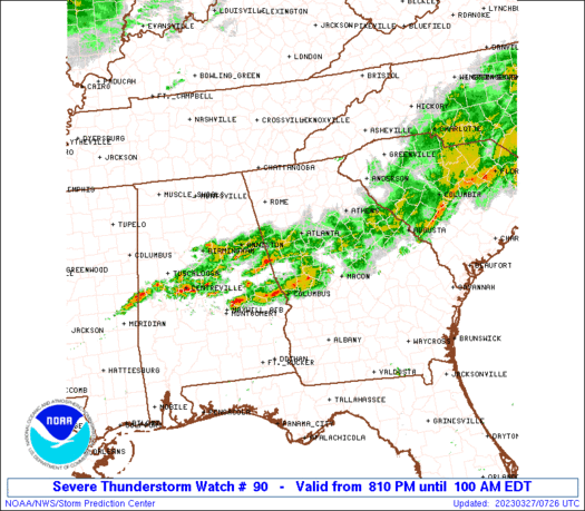
Severe Thunderstorm Watch Number 90
NWS Storm Prediction Center Norman OK
810 PM EDT Sun Mar 26 2023
The NWS Storm Prediction Center has issued a
* Severe Thunderstorm Watch for portions of
West central Georgia
* Effective this Sunday night and Monday morning from 810 PM
until 100 AM EDT.
* Primary threats include...
Scattered large hail and isolated very large hail events to 2
inches in diameter possible
Scattered damaging wind gusts to 70 mph possible
A tornado or two possible
SUMMARY...Clusters of storms, including both left- and right-moving
supercells, will likely persist for the next several hours with an
attendant threat for large hail up to 2 inches in diameter. The
potential for damaging winds and a tornado or two will increase some
later tonight, as storm clusters move eastward from Alabama into
western Georgia.
The severe thunderstorm watch area is approximately along and 45
statute miles north and south of a line from 10 miles west northwest
of La Grange GA to 55 miles east of Atlanta GA. For a complete
depiction of the watch see the associated watch outline update
(WOUS64 KWNS WOU0).
PRECAUTIONARY/PREPAREDNESS ACTIONS...
REMEMBER...A Severe Thunderstorm Watch means conditions are
favorable for severe thunderstorms in and close to the watch area.
Persons in these areas should be on the lookout for threatening
weather conditions and listen for later statements and possible
warnings. Severe thunderstorms can and occasionally do produce
tornadoes.
&&
OTHER WATCH INFORMATION...CONTINUE...WW 88...WW 89...
AVIATION...A few severe thunderstorms with hail surface and aloft to
2 inches. Extreme turbulence and surface wind gusts to 60 knots. A
few cumulonimbi with maximum tops to 500. Mean storm motion vector
23035.
...Thompson
   SEL0

   URGENT - IMMEDIATE BROADCAST REQUESTED
   Severe Thunderstorm Watch Number 90
   NWS Storm Prediction Center Norman OK
   810 PM EDT Sun Mar 26 2023

   The NWS Storm Prediction Center has issued a

   * Severe Thunderstorm Watch for portions of
     West central Georgia

   * Effective this Sunday night and Monday morning from 810 PM
     until 100 AM EDT.

   * Primary threats include...
     Scattered large hail and isolated very large hail events to 2
       inches in diameter possible
     Scattered damaging wind gusts to 70 mph possible
     A tornado or two possible

   SUMMARY...Clusters of storms, including both left- and right-moving
   supercells, will likely persist for the next several hours with an
   attendant threat for large hail up to 2 inches in diameter.  The
   potential for damaging winds and a tornado or two will increase some
   later tonight, as storm clusters move eastward from Alabama into
   western Georgia.

   The severe thunderstorm watch area is approximately along and 45
   statute miles north and south of a line from 10 miles west northwest
   of La Grange GA to 55 miles east of Atlanta GA. For a complete
   depiction of the watch see the associated watch outline update
   (WOUS64 KWNS WOU0).

   PRECAUTIONARY/PREPAREDNESS ACTIONS...

   REMEMBER...A Severe Thunderstorm Watch means conditions are
   favorable for severe thunderstorms in and close to the watch area.
   Persons in these areas should be on the lookout for threatening
   weather conditions and listen for later statements and possible
   warnings. Severe thunderstorms can and occasionally do produce
   tornadoes.

   &&

   OTHER WATCH INFORMATION...CONTINUE...WW 88...WW 89...

   AVIATION...A few severe thunderstorms with hail surface and aloft to
   2 inches. Extreme turbulence and surface wind gusts to 60 knots. A
   few cumulonimbi with maximum tops to 500. Mean storm motion vector
   23035.

   ...Thompson
 Note:
The Aviation Watch (SAW) product is an approximation to the watch area.
The actual watch is depicted by the shaded areas.
Note:
The Aviation Watch (SAW) product is an approximation to the watch area.
The actual watch is depicted by the shaded areas.
SAW0
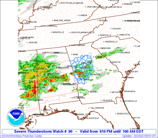
WW 90 SEVERE TSTM GA 270010Z - 270500Z
AXIS..45 STATUTE MILES NORTH AND SOUTH OF LINE..
10WNW LGC/LA GRANGE GA/ - 55E ATL/ATLANTA GA/
..AVIATION COORDS.. 40NM N/S /1WNW LGC - 48E ATL/
HAIL SURFACE AND ALOFT..2 INCHES. WIND GUSTS..60 KNOTS.
MAX TOPS TO 500. MEAN STORM MOTION VECTOR 23035.
LAT...LON 33718523 34288347 32988347 32408523
THIS IS AN APPROXIMATION TO THE WATCH AREA. FOR A
COMPLETE DEPICTION OF THE WATCH SEE WOUS64 KWNS
FOR WOU0.
Watch 90 Status Report Messages:
STATUS REPORT #5 ON WW 90

VALID 270430Z - 270540Z

SEVERE WEATHER THREAT CONTINUES RIGHT OF A LINE FROM 15 ENE AUO
TO 30 E ATL TO 10 SW AHN.

..KERR..03/27/23

ATTN...WFO...FFC...

&&

STATUS REPORT FOR WS 90

SEVERE WEATHER THREAT CONTINUES FOR THE FOLLOWING AREAS

GAC009-021-023-035-053-079-133-141-145-153-159-167-169-171-175-
193-197-199-207-211-215-217-219-225-231-237-249-255-263-269-289-
293-303-319-270540-

GA
.    GEORGIA COUNTIES INCLUDED ARE

BALDWIN 	     BIBB		 BLECKLEY
BUTTS		     CHATTAHOOCHEE	 CRAWFORD
GREENE		     HANCOCK		 HARRIS
HOUSTON 	     JASPER		 JOHNSON
JONES		     LAMAR		 LAURENS
MACON		     MARION		 MERIWETHER
MONROE		     MORGAN		 MUSCOGEE
NEWTON		     OCONEE		 PEACH
PIKE		     PUTNAM		 SCHLEY
SPALDING	     TALBOT		 TAYLOR
TWIGGS		     UPSON		 WASHINGTON
WILKINSON
$$


THE WATCH STATUS MESSAGE IS FOR GUIDANCE PURPOSES ONLY.  PLEASE
REFER TO WATCH COUNTY NOTIFICATION STATEMENTS FOR OFFICIAL
INFORMATION ON COUNTIES...INDEPENDENT CITIES AND MARINE ZONES
CLEARED FROM SEVERE THUNDERSTORM AND TORNADO WATCHES.
$$

STATUS REPORT #4 ON WW 90

VALID 270330Z - 270440Z

SEVERE WEATHER THREAT CONTINUES RIGHT OF A LINE FROM 25 NNW LGC
TO 25 NNW AHN.

..KERR..03/27/23

ATTN...WFO...FFC...

&&

STATUS REPORT FOR WS 90

SEVERE WEATHER THREAT CONTINUES FOR THE FOLLOWING AREAS

GAC013-035-053-063-077-079-089-113-121-135-145-149-151-159-171-
197-199-207-215-217-231-247-255-263-269-285-293-297-270440-

GA
.    GEORGIA COUNTIES INCLUDED ARE

BARROW		     BUTTS		 CHATTAHOOCHEE
CLAYTON 	     COWETA		 CRAWFORD
DEKALB		     FAYETTE		 FULTON
GWINNETT	     HARRIS		 HEARD
HENRY		     JASPER		 LAMAR
MARION		     MERIWETHER 	 MONROE
MUSCOGEE	     NEWTON		 PIKE
ROCKDALE	     SPALDING		 TALBOT
TAYLOR		     TROUP		 UPSON
WALTON
$$


THE WATCH STATUS MESSAGE IS FOR GUIDANCE PURPOSES ONLY.  PLEASE
REFER TO WATCH COUNTY NOTIFICATION STATEMENTS FOR OFFICIAL
INFORMATION ON COUNTIES...INDEPENDENT CITIES AND MARINE ZONES
CLEARED FROM SEVERE THUNDERSTORM AND TORNADO WATCHES.
$$

STATUS REPORT #3 ON WW 90

VALID 270230Z - 270340Z

SEVERE WEATHER THREAT CONTINUES RIGHT OF A LINE FROM 30 NNW LGC
TO 25 NNE ATL.

..KERR..03/27/23

ATTN...WFO...FFC...

&&

STATUS REPORT FOR WS 90

SEVERE WEATHER THREAT CONTINUES FOR THE FOLLOWING AREAS

GAC013-035-045-053-063-067-077-079-089-097-113-121-135-145-149-
151-159-171-197-199-207-215-217-231-247-255-263-269-285-293-297-
270340-

GA
.    GEORGIA COUNTIES INCLUDED ARE

BARROW		     BUTTS		 CARROLL
CHATTAHOOCHEE	     CLAYTON		 COBB
COWETA		     CRAWFORD		 DEKALB
DOUGLAS 	     FAYETTE		 FULTON
GWINNETT	     HARRIS		 HEARD
HENRY		     JASPER		 LAMAR
MARION		     MERIWETHER 	 MONROE
MUSCOGEE	     NEWTON		 PIKE
ROCKDALE	     SPALDING		 TALBOT
TAYLOR		     TROUP		 UPSON
WALTON
$$


THE WATCH STATUS MESSAGE IS FOR GUIDANCE PURPOSES ONLY.  PLEASE
REFER TO WATCH COUNTY NOTIFICATION STATEMENTS FOR OFFICIAL
INFORMATION ON COUNTIES...INDEPENDENT CITIES AND MARINE ZONES
CLEARED FROM SEVERE THUNDERSTORM AND TORNADO WATCHES.
$$

STATUS REPORT #2 ON WW 90

VALID 270150Z - 270240Z

THE SEVERE WEATHER THREAT CONTINUES ACROSS THE ENTIRE WATCH AREA.

..KERR..03/27/23

ATTN...WFO...FFC...

&&

STATUS REPORT FOR WS 90

SEVERE WEATHER THREAT CONTINUES FOR THE FOLLOWING AREAS

GAC013-035-045-053-063-067-077-079-089-097-113-121-135-143-145-
149-151-159-171-197-199-207-215-217-223-231-247-255-263-269-285-
293-297-270240-

GA
.    GEORGIA COUNTIES INCLUDED ARE

BARROW		     BUTTS		 CARROLL
CHATTAHOOCHEE	     CLAYTON		 COBB
COWETA		     CRAWFORD		 DEKALB
DOUGLAS 	     FAYETTE		 FULTON
GWINNETT	     HARALSON		 HARRIS
HEARD		     HENRY		 JASPER
LAMAR		     MARION		 MERIWETHER
MONROE		     MUSCOGEE		 NEWTON
PAULDING	     PIKE		 ROCKDALE
SPALDING	     TALBOT		 TAYLOR
TROUP		     UPSON		 WALTON
$$


THE WATCH STATUS MESSAGE IS FOR GUIDANCE PURPOSES ONLY.  PLEASE
REFER TO WATCH COUNTY NOTIFICATION STATEMENTS FOR OFFICIAL
INFORMATION ON COUNTIES...INDEPENDENT CITIES AND MARINE ZONES
CLEARED FROM SEVERE THUNDERSTORM AND TORNADO WATCHES.
$$

STATUS REPORT #1 ON WW 90

VALID 270040Z - 270140Z

THE SEVERE WEATHER THREAT CONTINUES ACROSS THE ENTIRE WATCH AREA.

..THORNTON..03/27/23

ATTN...WFO...FFC...

&&

STATUS REPORT FOR WS 90

SEVERE WEATHER THREAT CONTINUES FOR THE FOLLOWING AREAS

GAC013-035-045-053-063-067-077-079-089-097-113-121-135-143-145-
149-151-159-171-197-199-207-215-217-223-231-247-255-263-269-285-
293-297-270140-

GA
.    GEORGIA COUNTIES INCLUDED ARE

BARROW		     BUTTS		 CARROLL
CHATTAHOOCHEE	     CLAYTON		 COBB
COWETA		     CRAWFORD		 DEKALB
DOUGLAS 	     FAYETTE		 FULTON
GWINNETT	     HARALSON		 HARRIS
HEARD		     HENRY		 JASPER
LAMAR		     MARION		 MERIWETHER
MONROE		     MUSCOGEE		 NEWTON
PAULDING	     PIKE		 ROCKDALE
SPALDING	     TALBOT		 TAYLOR
TROUP		     UPSON		 WALTON
$$


THE WATCH STATUS MESSAGE IS FOR GUIDANCE PURPOSES ONLY.  PLEASE
REFER TO WATCH COUNTY NOTIFICATION STATEMENTS FOR OFFICIAL
INFORMATION ON COUNTIES...INDEPENDENT CITIES AND MARINE ZONES
CLEARED FROM SEVERE THUNDERSTORM AND TORNADO WATCHES.
$$
Note:
Click for Complete Product Text.
Tornadoes
Probability of 2 or more tornadoes
|
Low (20%)
|
Probability of 1 or more strong (EF2-EF5) tornadoes
|
Low (5%)
|
Wind
Probability of 10 or more severe wind events
|
Mod (40%)
|
Probability of 1 or more wind events > 65 knots
|
Low (20%)
|
Hail
Probability of 10 or more severe hail events
|
Mod (40%)
|
Probability of 1 or more hailstones > 2 inches
|
Mod (40%)
|
Combined Severe Hail/Wind
Probability of 6 or more combined severe hail/wind events
|
High (70%)
|
For each watch, probabilities for particular events inside the watch
(listed above in each table) are determined by the issuing forecaster.
The "Low" category contains probability values ranging from less than 2%
to 20% (EF2-EF5 tornadoes), less than 5% to 20% (all other probabilities),
"Moderate" from 30% to 60%, and "High" from 70% to greater than 95%.
High values are bolded and lighter in color to provide awareness of
an increased threat for a particular event.


 @NWSSPC


