 Note:
The expiration time in the watch graphic is amended if the watch is
replaced, cancelled or extended.
Note:
Note:
The expiration time in the watch graphic is amended if the watch is
replaced, cancelled or extended.
Note: Click for
Watch Status Reports.
SEL7
URGENT - IMMEDIATE BROADCAST REQUESTED
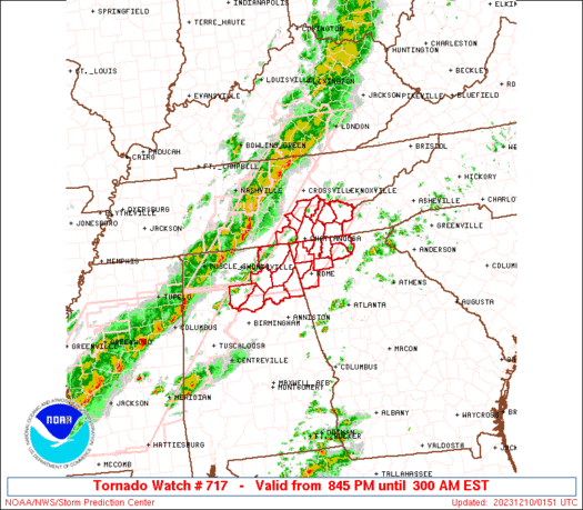
Tornado Watch Number 717
NWS Storm Prediction Center Norman OK
845 PM EST Sat Dec 9 2023
The NWS Storm Prediction Center has issued a
* Tornado Watch for portions of
northern Alabama
northwestern Georgia
southeastern Tennessee
* Effective this Saturday night and Sunday morning from 845 PM
until 300 AM EST.
* Primary threats include...
A couple tornadoes possible
Scattered damaging wind gusts to 65 mph possible
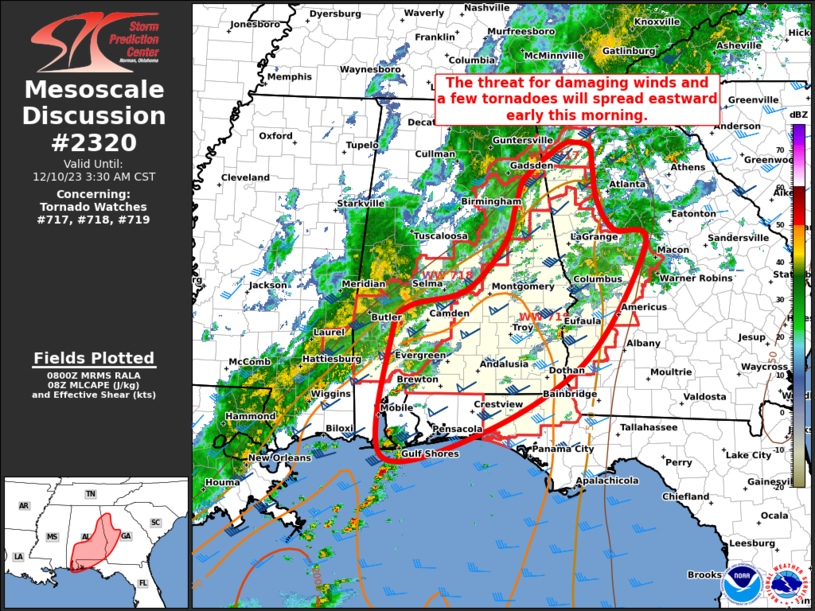
SUMMARY...An advancing line of strong/locally severe thunderstorms
will continue moving eastward into/across the southern Appalachians
region this evening and into the overnight period. Locally damaging
wind gusts, and a brief tornado or two, will be the main risks with
these storms.
The tornado watch area is approximately along and 45 statute miles
east and west of a line from 60 miles northeast of Chattanooga TN to
50 miles west southwest of Rome GA. For a complete depiction of the
watch see the associated watch outline update (WOUS64 KWNS WOU7).
PRECAUTIONARY/PREPAREDNESS ACTIONS...
REMEMBER...A Tornado Watch means conditions are favorable for
tornadoes and severe thunderstorms in and close to the watch
area. Persons in these areas should be on the lookout for
threatening weather conditions and listen for later statements
and possible warnings.
&&
OTHER WATCH INFORMATION...CONTINUE...WW 715...WW 716...
AVIATION...Tornadoes and a few severe thunderstorms with hail
surface and aloft to 1 inch. Extreme turbulence and surface wind
gusts to 55 knots. A few cumulonimbi with maximum tops to 450. Mean
storm motion vector 25040.
...Goss
   SEL7

   URGENT - IMMEDIATE BROADCAST REQUESTED
   Tornado Watch Number 717
   NWS Storm Prediction Center Norman OK
   845 PM EST Sat Dec 9 2023

   The NWS Storm Prediction Center has issued a

   * Tornado Watch for portions of
     northern Alabama
     northwestern Georgia
     southeastern Tennessee

   * Effective this Saturday night and Sunday morning from 845 PM
     until 300 AM EST.

   * Primary threats include...
     A couple tornadoes possible
     Scattered damaging wind gusts to 65 mph possible

   SUMMARY...An advancing line of strong/locally severe thunderstorms
   will continue moving eastward into/across the southern Appalachians
   region this evening and into the overnight period.  Locally damaging
   wind gusts, and a brief tornado or two, will be the main risks with
   these storms.

   The tornado watch area is approximately along and 45 statute miles
   east and west of a line from 60 miles northeast of Chattanooga TN to
   50 miles west southwest of Rome GA. For a complete depiction of the
   watch see the associated watch outline update (WOUS64 KWNS WOU7).

   PRECAUTIONARY/PREPAREDNESS ACTIONS...

   REMEMBER...A Tornado Watch means conditions are favorable for
   tornadoes and severe thunderstorms in and close to the watch
   area. Persons in these areas should be on the lookout for
   threatening weather conditions and listen for later statements
   and possible warnings.

   &&

   OTHER WATCH INFORMATION...CONTINUE...WW 715...WW 716...

   AVIATION...Tornadoes and a few severe thunderstorms with hail
   surface and aloft to 1 inch. Extreme turbulence and surface wind
   gusts to 55 knots. A few cumulonimbi with maximum tops to 450. Mean
   storm motion vector 25040.

   ...Goss
 Note:
The Aviation Watch (SAW) product is an approximation to the watch area.
The actual watch is depicted by the shaded areas.
Note:
The Aviation Watch (SAW) product is an approximation to the watch area.
The actual watch is depicted by the shaded areas.
   SAW7
   WW 717 TORNADO AL GA TN 100145Z - 100800Z
   AXIS..45 STATUTE MILES EAST AND WEST OF LINE..
   60NE CHA/CHATTANOOGA TN/ - 50WSW RMG/ROME GA/
   ..AVIATION COORDS.. 40NM E/W /31WSW VXV - 52ENE VUZ/
   HAIL SURFACE AND ALOFT..1 INCH. WIND GUSTS..55 KNOTS.
   MAX TOPS TO 450. MEAN STORM MOTION VECTOR 25040.

   LAT...LON 35648364 34078519 34078676 35648525

   THIS IS AN APPROXIMATION TO THE WATCH AREA.  FOR A
   COMPLETE DEPICTION OF THE WATCH SEE WOUS64 KWNS
   FOR WOU7.
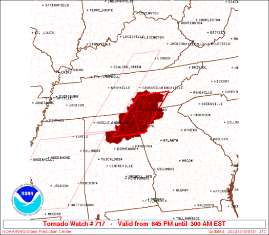
Watch 717 Status Report Messages:
STATUS REPORT #5 ON WW 717

VALID 100740Z - 100840Z

SEVERE WEATHER THREAT CONTINUES RIGHT OF A LINE FROM 5 S GAD TO 5
NNW RMG TO 20 E RMG.

..GLEASON..12/10/23

ATTN...WFO...BMX...HUN...FFC...MRX...

&&

STATUS REPORT FOR WT 717

SEVERE WEATHER THREAT CONTINUES FOR THE FOLLOWING AREAS

ALC019-055-100840-

AL
.    ALABAMA COUNTIES INCLUDED ARE

CHEROKEE	     ETOWAH
$$


GAC115-100840-

GA
.    GEORGIA COUNTIES INCLUDED ARE

FLOYD
$$


THE WATCH STATUS MESSAGE IS FOR GUIDANCE PURPOSES ONLY.  PLEASE
REFER TO WATCH COUNTY NOTIFICATION STATEMENTS FOR OFFICIAL
INFORMATION ON COUNTIES...INDEPENDENT CITIES AND MARINE ZONES
CLEARED FROM SEVERE THUNDERSTORM AND TORNADO WATCHES.
$$

STATUS REPORT #4 ON WW 717

VALID 100640Z - 100740Z

SEVERE WEATHER THREAT CONTINUES RIGHT OF A LINE FROM 5 WSW GAD TO
15 NNE RMG TO 40 E CHA TO 60 S TYS.

FOR ADDITIONAL INFORMATION SEE MESOSCALE DISCUSSION 2318

..GLEASON..12/10/23

ATTN...WFO...BMX...HUN...FFC...MRX...

&&

STATUS REPORT FOR WT 717

SEVERE WEATHER THREAT CONTINUES FOR THE FOLLOWING AREAS

ALC019-055-100740-

AL
.    ALABAMA COUNTIES INCLUDED ARE

CHEROKEE	     ETOWAH
$$


GAC111-115-123-129-213-100740-

GA
.    GEORGIA COUNTIES INCLUDED ARE

FANNIN		     FLOYD		 GILMER
GORDON		     MURRAY
$$


THE WATCH STATUS MESSAGE IS FOR GUIDANCE PURPOSES ONLY.  PLEASE
REFER TO WATCH COUNTY NOTIFICATION STATEMENTS FOR OFFICIAL
INFORMATION ON COUNTIES...INDEPENDENT CITIES AND MARINE ZONES
CLEARED FROM SEVERE THUNDERSTORM AND TORNADO WATCHES.
$$

STATUS REPORT #3 ON WW 717

VALID 100550Z - 100640Z

SEVERE WEATHER THREAT CONTINUES RIGHT OF A LINE FROM 5 W GAD TO
30 NW RMG TO 15 W TYS.

..SQUITIERI..12/10/23

ATTN...WFO...BMX...HUN...FFC...MRX...

&&

STATUS REPORT FOR WT 717

SEVERE WEATHER THREAT CONTINUES FOR THE FOLLOWING AREAS

ALC019-055-100640-

AL
.    ALABAMA COUNTIES INCLUDED ARE

CHEROKEE	     ETOWAH
$$


GAC047-055-111-115-123-129-213-295-313-100640-

GA
.    GEORGIA COUNTIES INCLUDED ARE

CATOOSA 	     CHATTOOGA		 FANNIN
FLOYD		     GILMER		 GORDON
MURRAY		     WALKER		 WHITFIELD
$$


TNC011-107-123-139-100640-

TN
.    TENNESSEE COUNTIES INCLUDED ARE

BRADLEY 	     MCMINN		 MONROE
POLK
$$


THE WATCH STATUS MESSAGE IS FOR GUIDANCE PURPOSES ONLY.  PLEASE
REFER TO WATCH COUNTY NOTIFICATION STATEMENTS FOR OFFICIAL
INFORMATION ON COUNTIES...INDEPENDENT CITIES AND MARINE ZONES
CLEARED FROM SEVERE THUNDERSTORM AND TORNADO WATCHES.
$$

STATUS REPORT #2 ON WW 717

VALID 100510Z - 100640Z

SEVERE WEATHER THREAT CONTINUES RIGHT OF A LINE FROM 15 ESE HSV
TO 35 WSW CHA TO 30 ESE CSV.

..SQUITIERI..12/10/23

ATTN...WFO...BMX...HUN...FFC...MRX...

&&

STATUS REPORT FOR WT 717

SEVERE WEATHER THREAT CONTINUES FOR THE FOLLOWING AREAS

ALC009-019-049-055-095-100640-

AL
.    ALABAMA COUNTIES INCLUDED ARE

BLOUNT		     CHEROKEE		 DEKALB
ETOWAH		     MARSHALL
$$


GAC047-055-083-111-115-123-129-213-295-313-100640-

GA
.    GEORGIA COUNTIES INCLUDED ARE

CATOOSA 	     CHATTOOGA		 DADE
FANNIN		     FLOYD		 GILMER
GORDON		     MURRAY		 WALKER
WHITFIELD
$$


TNC011-065-107-121-123-139-100640-

TN
.    TENNESSEE COUNTIES INCLUDED ARE

BRADLEY 	     HAMILTON		 MCMINN
MEIGS		     MONROE		 POLK
$$


THE WATCH STATUS MESSAGE IS FOR GUIDANCE PURPOSES ONLY.  PLEASE
REFER TO WATCH COUNTY NOTIFICATION STATEMENTS FOR OFFICIAL
INFORMATION ON COUNTIES...INDEPENDENT CITIES AND MARINE ZONES
CLEARED FROM SEVERE THUNDERSTORM AND TORNADO WATCHES.
$$

STATUS REPORT #1 ON WW 717

VALID 100350Z - 100440Z

THE SEVERE WEATHER THREAT CONTINUES ACROSS THE ENTIRE WATCH AREA.

FOR ADDITIONAL INFORMATION SEE MESOSCALE DISCUSSION 2317

..SQUITIERI..12/10/23

ATTN...WFO...BMX...HUN...FFC...MRX...

&&

STATUS REPORT FOR WT 717

SEVERE WEATHER THREAT CONTINUES FOR THE FOLLOWING AREAS

ALC009-019-043-049-055-071-095-100440-

AL
.    ALABAMA COUNTIES INCLUDED ARE

BLOUNT		     CHEROKEE		 CULLMAN
DEKALB		     ETOWAH		 JACKSON
MARSHALL
$$


GAC047-055-083-111-115-123-129-213-295-313-100440-

GA
.    GEORGIA COUNTIES INCLUDED ARE

CATOOSA 	     CHATTOOGA		 DADE
FANNIN		     FLOYD		 GILMER
GORDON		     MURRAY		 WALKER
WHITFIELD
$$


TNC007-011-065-107-115-121-123-139-143-153-100440-

TN
.    TENNESSEE COUNTIES INCLUDED ARE

BLEDSOE 	     BRADLEY		 HAMILTON
MCMINN		     MARION		 MEIGS
MONROE		     POLK		 RHEA
SEQUATCHIE
$$


THE WATCH STATUS MESSAGE IS FOR GUIDANCE PURPOSES ONLY.  PLEASE
REFER TO WATCH COUNTY NOTIFICATION STATEMENTS FOR OFFICIAL
INFORMATION ON COUNTIES...INDEPENDENT CITIES AND MARINE ZONES
CLEARED FROM SEVERE THUNDERSTORM AND TORNADO WATCHES.
$$
Note:
Click for Complete Product Text.
Tornadoes
Probability of 2 or more tornadoes
|
Mod (30%)
|
Probability of 1 or more strong (EF2-EF5) tornadoes
|
Low (20%)
|
Wind
Probability of 10 or more severe wind events
|
Mod (50%)
|
Probability of 1 or more wind events > 65 knots
|
Low (10%)
|
Hail
Probability of 10 or more severe hail events
|
Low (<5%)
|
Probability of 1 or more hailstones > 2 inches
|
Low (<5%)
|
Combined Severe Hail/Wind
Probability of 6 or more combined severe hail/wind events
|
Mod (60%)
|
For each watch, probabilities for particular events inside the watch
(listed above in each table) are determined by the issuing forecaster.
The "Low" category contains probability values ranging from less than 2%
to 20% (EF2-EF5 tornadoes), less than 5% to 20% (all other probabilities),
"Moderate" from 30% to 60%, and "High" from 70% to greater than 95%.
High values are bolded and lighter in color to provide awareness of
an increased threat for a particular event.


 @NWSSPC