 Note:
The expiration time in the watch graphic is amended if the watch is
replaced, cancelled or extended.
Note:
Note:
The expiration time in the watch graphic is amended if the watch is
replaced, cancelled or extended.
Note: Click for
Watch Status Reports.
SEL8
URGENT - IMMEDIATE BROADCAST REQUESTED
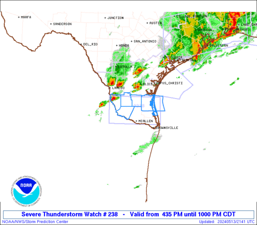
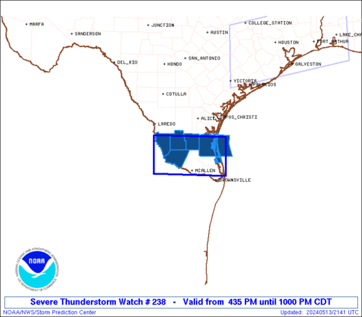
Severe Thunderstorm Watch Number 238
NWS Storm Prediction Center Norman OK
435 PM CDT Mon May 13 2024
The NWS Storm Prediction Center has issued a
* Severe Thunderstorm Watch for portions of
Deep South Texas
Coastal Waters
* Effective this Monday afternoon and evening from 435 PM until
1000 PM CDT.
* Primary threats include...
Scattered large hail and isolated very large hail events to 2
inches in diameter possible
Isolated damaging wind gusts to 70 mph possible
SUMMARY...Thunderstorms will build/move southeastward into deep
south Texas this evening, with a few cells posing a risk of damaging
winds and large hail.
The severe thunderstorm watch area is approximately along and 40
statute miles north and south of a line from 85 miles west northwest
of Mcallen TX to 75 miles east northeast of Mcallen TX. For a
complete depiction of the watch see the associated watch outline
update (WOUS64 KWNS WOU8).
PRECAUTIONARY/PREPAREDNESS ACTIONS...
REMEMBER...A Severe Thunderstorm Watch means conditions are
favorable for severe thunderstorms in and close to the watch area.
Persons in these areas should be on the lookout for threatening
weather conditions and listen for later statements and possible
warnings. Severe thunderstorms can and occasionally do produce
tornadoes.
&&
OTHER WATCH INFORMATION...CONTINUE...WW 236...WW 237...
AVIATION...A few severe thunderstorms with hail surface and aloft to
2 inches. Extreme turbulence and surface wind gusts to 60 knots. A
few cumulonimbi with maximum tops to 500. Mean storm motion vector
29030.
...Hart

   SEL8

   URGENT - IMMEDIATE BROADCAST REQUESTED
   Severe Thunderstorm Watch Number 238
   NWS Storm Prediction Center Norman OK
   435 PM CDT Mon May 13 2024

   The NWS Storm Prediction Center has issued a

   * Severe Thunderstorm Watch for portions of
     Deep South Texas
     Coastal Waters

   * Effective this Monday afternoon and evening from 435 PM until
     1000 PM CDT.

   * Primary threats include...
     Scattered large hail and isolated very large hail events to 2
       inches in diameter possible
     Isolated damaging wind gusts to 70 mph possible

   SUMMARY...Thunderstorms will build/move southeastward into deep
   south Texas this evening, with a few cells posing a risk of damaging
   winds and large hail.

   The severe thunderstorm watch area is approximately along and 40
   statute miles north and south of a line from 85 miles west northwest
   of Mcallen TX to 75 miles east northeast of Mcallen TX. For a
   complete depiction of the watch see the associated watch outline
   update (WOUS64 KWNS WOU8).

   PRECAUTIONARY/PREPAREDNESS ACTIONS...

   REMEMBER...A Severe Thunderstorm Watch means conditions are
   favorable for severe thunderstorms in and close to the watch area.
   Persons in these areas should be on the lookout for threatening
   weather conditions and listen for later statements and possible
   warnings. Severe thunderstorms can and occasionally do produce
   tornadoes.

   &&

   OTHER WATCH INFORMATION...CONTINUE...WW 236...WW 237...

   AVIATION...A few severe thunderstorms with hail surface and aloft to
   2 inches. Extreme turbulence and surface wind gusts to 60 knots. A
   few cumulonimbi with maximum tops to 500. Mean storm motion vector
   29030.

   ...Hart
 Note:
The Aviation Watch (SAW) product is an approximation to the watch area.
The actual watch is depicted by the shaded areas.
Note:
The Aviation Watch (SAW) product is an approximation to the watch area.
The actual watch is depicted by the shaded areas.
   SAW8
   WW 238 SEVERE TSTM TX CW 132135Z - 140300Z
   AXIS..40 STATUTE MILES NORTH AND SOUTH OF LINE..
   85WNW MFE/MCALLEN TX/ - 75ENE MFE/MCALLEN TX/
   ..AVIATION COORDS.. 35NM N/S /50S LRD - 43NNE BRO/
   HAIL SURFACE AND ALOFT..2 INCHES. WIND GUSTS..60 KNOTS.
   MAX TOPS TO 500. MEAN STORM MOTION VECTOR 29030.

   LAT...LON 27229950 27179711 26019711 26079950

   THIS IS AN APPROXIMATION TO THE WATCH AREA.  FOR A
   COMPLETE DEPICTION OF THE WATCH SEE WOUS64 KWNS
   FOR WOU8.
Watch 238 Status Report Messages:
STATUS REPORT #1 ON WW 238

VALID 140050Z - 140140Z

SEVERE WEATHER THREAT CONTINUES RIGHT OF A LINE FROM 80 W MFE TO
50 ESE LRD.

..SPC..05/14/24

ATTN...WFO...BRO...

&&

STATUS REPORT FOR WS 238

SEVERE WEATHER THREAT CONTINUES FOR THE FOLLOWING AREAS

TXC047-061-215-247-261-427-489-140140-

TX
.    TEXAS COUNTIES INCLUDED ARE

BROOKS		     CAMERON		 HIDALGO
JIM HOGG	     KENEDY		 STARR
WILLACY
$$


GMZ130-132-135-150-155-140140-

CW

.    ADJACENT COASTAL WATERS INCLUDED ARE

LAGUNA MADRE FROM THE PORT OF BROWNSVILLE TO THE ARROYO COLORADO

LAGUNA MADRE FROM THE ARROYO COLORADO TO 5 NM NORTH OF PORT
MANSFIELD TX

LAGUNA MADRE FROM 5 NM NORTH OF PORT MANSFIELD TO BAFFIN BAY TX

COASTAL WATERS FROM PORT MANSFIELD TX TO THE RIO GRANDE RIVER OUT
20 NM

COASTAL WATERS FROM BAFFIN BAY TO PORT MANSFIELD TX OUT 20 NM

$$
THE WATCH STATUS MESSAGE IS FOR GUIDANCE PURPOSES ONLY.  PLEASE
REFER TO WATCH COUNTY NOTIFICATION STATEMENTS FOR OFFICIAL
INFORMATION ON COUNTIES...INDEPENDENT CITIES AND MARINE ZONES
CLEARED FROM SEVERE THUNDERSTORM AND TORNADO WATCHES.
$$
Note:
Click for Complete Product Text.
Tornadoes
Probability of 2 or more tornadoes
|
Low (<5%)
|
Probability of 1 or more strong (EF2-EF5) tornadoes
|
Low (<2%)
|
Wind
Probability of 10 or more severe wind events
|
Low (20%)
|
Probability of 1 or more wind events > 65 knots
|
Low (10%)
|
Hail
Probability of 10 or more severe hail events
|
Mod (40%)
|
Probability of 1 or more hailstones > 2 inches
|
Mod (30%)
|
Combined Severe Hail/Wind
Probability of 6 or more combined severe hail/wind events
|
Mod (60%)
|
For each watch, probabilities for particular events inside the watch
(listed above in each table) are determined by the issuing forecaster.
The "Low" category contains probability values ranging from less than 2%
to 20% (EF2-EF5 tornadoes), less than 5% to 20% (all other probabilities),
"Moderate" from 30% to 60%, and "High" from 70% to greater than 95%.
High values are bolded and lighter in color to provide awareness of
an increased threat for a particular event.


 @NWSSPC


