 Note:
The expiration time in the watch graphic is amended if the watch is
replaced, cancelled or extended.
Note:
Note:
The expiration time in the watch graphic is amended if the watch is
replaced, cancelled or extended.
Note: Click for
Watch Status Reports.
SEL3
URGENT - IMMEDIATE BROADCAST REQUESTED
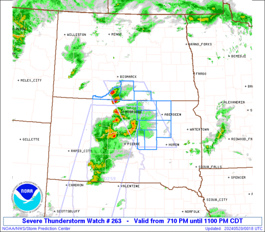
Severe Thunderstorm Watch Number 263
NWS Storm Prediction Center Norman OK
710 PM CDT Sun May 19 2024
The NWS Storm Prediction Center has issued a
* Severe Thunderstorm Watch for portions of
Southern North Dakota
Northeast South Dakota
* Effective this Sunday evening from 710 PM until 1100 PM CDT.
* Primary threats include...
Scattered large hail events to 1.5 inches in diameter possible
Isolated damaging wind gusts to 70 mph possible
SUMMARY...Scattered strong to severe thunderstorms will potentially
be capable of 60-70 mph gusts and large hail 1 to 1.5 inches in
diameter through the evening hours. The severe risk is forecast to
diminish by late evening.
The severe thunderstorm watch area is approximately along and 50
statute miles east and west of a line from 75 miles north of
Mobridge SD to 120 miles southeast of Mobridge SD. For a complete
depiction of the watch see the associated watch outline update
(WOUS64 KWNS WOU3).
PRECAUTIONARY/PREPAREDNESS ACTIONS...
REMEMBER...A Severe Thunderstorm Watch means conditions are
favorable for severe thunderstorms in and close to the watch area.
Persons in these areas should be on the lookout for threatening
weather conditions and listen for later statements and possible
warnings. Severe thunderstorms can and occasionally do produce
tornadoes.
&&
OTHER WATCH INFORMATION...CONTINUE...WW 259...WW 260...WW
261...WW 262...
AVIATION...A few severe thunderstorms with hail surface and aloft to
1.5 inches. Extreme turbulence and surface wind gusts to 60 knots. A
few cumulonimbi with maximum tops to 400. Mean storm motion vector
23035.
...Smith
 Note:
The Aviation Watch (SAW) product is an approximation to the watch area.
The actual watch is depicted by the shaded areas.
Note:
The Aviation Watch (SAW) product is an approximation to the watch area.
The actual watch is depicted by the shaded areas.
   SAW3
   WW 263 SEVERE TSTM ND SD 200010Z - 200400Z
   AXIS..50 STATUTE MILES EAST AND WEST OF LINE..
   75N MBG/MOBRIDGE SD/ - 120SE MBG/MOBRIDGE SD/
   ..AVIATION COORDS.. 45NM E/W /14SE BIS - 63E PIR/
   HAIL SURFACE AND ALOFT..1.5 INCHES. WIND GUSTS..60 KNOTS.
   MAX TOPS TO 400. MEAN STORM MOTION VECTOR 23035.

   LAT...LON 46619938 44289770 44289973 46610148

   THIS IS AN APPROXIMATION TO THE WATCH AREA.  FOR A
   COMPLETE DEPICTION OF THE WATCH SEE WOUS64 KWNS
   FOR WOU3.
Watch 263 Status Report Messages:
STATUS REPORT #4 ON WW 263

VALID 200345Z - 200400Z

SEVERE WEATHER THREAT CONTINUES RIGHT OF A LINE FROM 15 WSW HON
TO 30 NNE HON.

REMAINING VALID PORTION OF WW 263 MAY BE ALLOWED TO EXPIRE AT
20/04Z.
..KERR..05/20/24

ATTN...WFO...BIS...ABR...

&&

STATUS REPORT FOR WS 263

SEVERE WEATHER THREAT CONTINUES FOR THE FOLLOWING AREAS

SDC013-059-115-200400-

SD
.    SOUTH DAKOTA COUNTIES INCLUDED ARE

BROWN		     HAND		 SPINK
$$


THE WATCH STATUS MESSAGE IS FOR GUIDANCE PURPOSES ONLY.  PLEASE
REFER TO WATCH COUNTY NOTIFICATION STATEMENTS FOR OFFICIAL
INFORMATION ON COUNTIES...INDEPENDENT CITIES AND MARINE ZONES
CLEARED FROM SEVERE THUNDERSTORM AND TORNADO WATCHES.
$$

STATUS REPORT #3 ON WW 263

VALID 200235Z - 200340Z

SEVERE WEATHER THREAT CONTINUES RIGHT OF A LINE FROM 30 N 9V9 TO
25 NW ABR.

..GRAMS..05/20/24

ATTN...WFO...BIS...ABR...

&&

STATUS REPORT FOR WS 263

SEVERE WEATHER THREAT CONTINUES FOR THE FOLLOWING AREAS

SDC013-059-115-200340-

SD
.    SOUTH DAKOTA COUNTIES INCLUDED ARE

BROWN		     HAND		 SPINK
$$


THE WATCH STATUS MESSAGE IS FOR GUIDANCE PURPOSES ONLY.  PLEASE
REFER TO WATCH COUNTY NOTIFICATION STATEMENTS FOR OFFICIAL
INFORMATION ON COUNTIES...INDEPENDENT CITIES AND MARINE ZONES
CLEARED FROM SEVERE THUNDERSTORM AND TORNADO WATCHES.
$$

STATUS REPORT #2 ON WW 263

VALID 200135Z - 200240Z

THE SEVERE WEATHER THREAT CONTINUES ACROSS THE ENTIRE WATCH AREA.

..MOORE..05/20/24

ATTN...WFO...BIS...ABR...

&&

STATUS REPORT FOR WS 263

SEVERE WEATHER THREAT CONTINUES FOR THE FOLLOWING AREAS

NDC029-051-085-200240-

ND
.    NORTH DAKOTA COUNTIES INCLUDED ARE

EMMONS		     MCINTOSH		 SIOUX
$$


SDC013-045-049-059-069-089-115-200240-

SD
.    SOUTH DAKOTA COUNTIES INCLUDED ARE

BROWN		     EDMUNDS		 FAULK
HAND		     HYDE		 MCPHERSON
SPINK
$$


THE WATCH STATUS MESSAGE IS FOR GUIDANCE PURPOSES ONLY.  PLEASE
REFER TO WATCH COUNTY NOTIFICATION STATEMENTS FOR OFFICIAL
INFORMATION ON COUNTIES...INDEPENDENT CITIES AND MARINE ZONES
CLEARED FROM SEVERE THUNDERSTORM AND TORNADO WATCHES.
$$

STATUS REPORT #1 ON WW 263

VALID 200100Z - 200240Z

THE SEVERE WEATHER THREAT CONTINUES ACROSS THE ENTIRE WATCH AREA.

..MOORE..05/20/24

ATTN...WFO...BIS...ABR...

&&

STATUS REPORT FOR WS 263

SEVERE WEATHER THREAT CONTINUES FOR THE FOLLOWING AREAS

NDC029-051-085-200240-

ND
.    NORTH DAKOTA COUNTIES INCLUDED ARE

EMMONS		     MCINTOSH		 SIOUX
$$


SDC013-045-049-059-069-089-115-200240-

SD
.    SOUTH DAKOTA COUNTIES INCLUDED ARE

BROWN		     EDMUNDS		 FAULK
HAND		     HYDE		 MCPHERSON
SPINK
$$


THE WATCH STATUS MESSAGE IS FOR GUIDANCE PURPOSES ONLY.  PLEASE
REFER TO WATCH COUNTY NOTIFICATION STATEMENTS FOR OFFICIAL
INFORMATION ON COUNTIES...INDEPENDENT CITIES AND MARINE ZONES
CLEARED FROM SEVERE THUNDERSTORM AND TORNADO WATCHES.
$$
Note:
Click for Complete Product Text.
Tornadoes
Probability of 2 or more tornadoes
|
Low (<5%)
|
Probability of 1 or more strong (EF2-EF5) tornadoes
|
Low (<2%)
|
Wind
Probability of 10 or more severe wind events
|
Mod (30%)
|
Probability of 1 or more wind events > 65 knots
|
Low (20%)
|
Hail
Probability of 10 or more severe hail events
|
Mod (40%)
|
Probability of 1 or more hailstones > 2 inches
|
Low (20%)
|
Combined Severe Hail/Wind
Probability of 6 or more combined severe hail/wind events
|
High (70%)
|
For each watch, probabilities for particular events inside the watch
(listed above in each table) are determined by the issuing forecaster.
The "Low" category contains probability values ranging from less than 2%
to 20% (EF2-EF5 tornadoes), less than 5% to 20% (all other probabilities),
"Moderate" from 30% to 60%, and "High" from 70% to greater than 95%.
High values are bolded and lighter in color to provide awareness of
an increased threat for a particular event.


 @NWSSPC


