 Note:
The expiration time in the watch graphic is amended if the watch is
replaced, cancelled or extended.
Note:
Note:
The expiration time in the watch graphic is amended if the watch is
replaced, cancelled or extended.
Note: Click for
Watch Status Reports.
SEL4
URGENT - IMMEDIATE BROADCAST REQUESTED
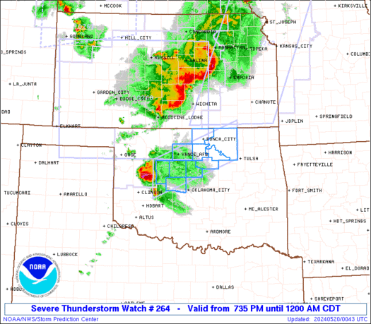
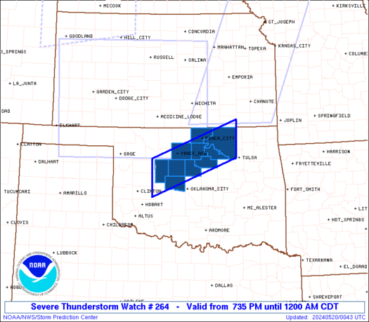
Severe Thunderstorm Watch Number 264
NWS Storm Prediction Center Norman OK
735 PM CDT Sun May 19 2024
The NWS Storm Prediction Center has issued a
* Severe Thunderstorm Watch for portions of
Central and Northern Oklahoma
* Effective this Sunday night from 735 PM until Midnight CDT.
* Primary threats include...
Scattered damaging winds and isolated significant gusts to 75
mph possible
Scattered large hail and isolated very large hail events to 2
inches in diameter possible
A tornado or two possible
SUMMARY...A cluster of severe thunderstorms will likely move east
into central Oklahoma during the evening. Additional isolated
severe thunderstorms are possible this evening. The risk for large
to very large hail and severe gusts will accompany any mature
supercell. The severe risk is expected to lessen later this evening
as convective inhibition strengthens.
The severe thunderstorm watch area is approximately along and 35
statute miles north and south of a line from 65 miles southwest of
Enid OK to 5 miles south southeast of Bartlesville OK. For a
complete depiction of the watch see the associated watch outline
update (WOUS64 KWNS WOU4).
PRECAUTIONARY/PREPAREDNESS ACTIONS...
REMEMBER...A Severe Thunderstorm Watch means conditions are
favorable for severe thunderstorms in and close to the watch area.
Persons in these areas should be on the lookout for threatening
weather conditions and listen for later statements and possible
warnings. Severe thunderstorms can and occasionally do produce
tornadoes.
&&
OTHER WATCH INFORMATION...CONTINUE...WW 259...WW 260...WW
261...WW 262...WW 263...
AVIATION...A few severe thunderstorms with hail surface and aloft to
2 inches. Extreme turbulence and surface wind gusts to 65 knots. A
few cumulonimbi with maximum tops to 550. Mean storm motion vector
27025.
...Smith
 Note:
The Aviation Watch (SAW) product is an approximation to the watch area.
The actual watch is depicted by the shaded areas.
Note:
The Aviation Watch (SAW) product is an approximation to the watch area.
The actual watch is depicted by the shaded areas.
   SAW4
   WW 264 SEVERE TSTM OK 200035Z - 200500Z
   AXIS..35 STATUTE MILES NORTH AND SOUTH OF LINE..
   65SW END/ENID OK/ - 5SSE BVO/BARTLESVILLE OK/
   ..AVIATION COORDS.. 30NM N/S /56SW END - 32NNW TUL/
   HAIL SURFACE AND ALOFT..2 INCHES. WIND GUSTS..65 KNOTS.
   MAX TOPS TO 550. MEAN STORM MOTION VECTOR 27025.

   LAT...LON 36189874 37219599 36209599 35189874

   THIS IS AN APPROXIMATION TO THE WATCH AREA.  FOR A
   COMPLETE DEPICTION OF THE WATCH SEE WOUS64 KWNS
   FOR WOU4.
Watch 264 Status Report Messages:
STATUS REPORT #4 ON WW 264

VALID 200435Z - 200500Z

SEVERE WEATHER THREAT CONTINUES RIGHT OF A LINE FROM 20 WNW CQB
TO 20 SE END TO 40 S AVK.

A NEW IS BEING ISSUED INCLUDING PARTS OF REMAINING VALID PORTION OF
WW 264.

..KERR..05/20/24

ATTN...WFO...OUN...TSA...

&&

STATUS REPORT FOR WS 264

SEVERE WEATHER THREAT CONTINUES FOR THE FOLLOWING AREAS

OKC047-071-103-113-117-119-200500-

OK
.    OKLAHOMA COUNTIES INCLUDED ARE

GARFIELD	     KAY		 NOBLE
OSAGE		     PAWNEE		 PAYNE
$$


THE WATCH STATUS MESSAGE IS FOR GUIDANCE PURPOSES ONLY.  PLEASE
REFER TO WATCH COUNTY NOTIFICATION STATEMENTS FOR OFFICIAL
INFORMATION ON COUNTIES...INDEPENDENT CITIES AND MARINE ZONES
CLEARED FROM SEVERE THUNDERSTORM AND TORNADO WATCHES.
$$

STATUS REPORT #3 ON WW 264

VALID 200350Z - 200440Z

SEVERE WEATHER THREAT CONTINUES RIGHT OF A LINE FROM 15 NNW OKC
TO 20 SE END TO 40 S AVK.

..KERR..05/20/24

ATTN...WFO...OUN...TSA...

&&

STATUS REPORT FOR WS 264

SEVERE WEATHER THREAT CONTINUES FOR THE FOLLOWING AREAS

OKC027-047-051-071-081-083-087-103-109-113-117-119-125-200440-

OK
.    OKLAHOMA COUNTIES INCLUDED ARE

CLEVELAND	     GARFIELD		 GRADY
KAY		     LINCOLN		 LOGAN
MCCLAIN 	     NOBLE		 OKLAHOMA
OSAGE		     PAWNEE		 PAYNE
POTTAWATOMIE
$$


THE WATCH STATUS MESSAGE IS FOR GUIDANCE PURPOSES ONLY.  PLEASE
REFER TO WATCH COUNTY NOTIFICATION STATEMENTS FOR OFFICIAL
INFORMATION ON COUNTIES...INDEPENDENT CITIES AND MARINE ZONES
CLEARED FROM SEVERE THUNDERSTORM AND TORNADO WATCHES.
$$

STATUS REPORT #2 ON WW 264

VALID 200235Z - 200340Z

THE SEVERE WEATHER THREAT CONTINUES ACROSS THE ENTIRE WATCH AREA.

..GRAMS..05/20/24

ATTN...WFO...OUN...TSA...

&&

STATUS REPORT FOR WS 264

SEVERE WEATHER THREAT CONTINUES FOR THE FOLLOWING AREAS

OKC011-017-047-071-073-083-103-113-117-119-200340-

OK
.    OKLAHOMA COUNTIES INCLUDED ARE

BLAINE		     CANADIAN		 GARFIELD
KAY		     KINGFISHER 	 LOGAN
NOBLE		     OSAGE		 PAWNEE
PAYNE
$$


THE WATCH STATUS MESSAGE IS FOR GUIDANCE PURPOSES ONLY.  PLEASE
REFER TO WATCH COUNTY NOTIFICATION STATEMENTS FOR OFFICIAL
INFORMATION ON COUNTIES...INDEPENDENT CITIES AND MARINE ZONES
CLEARED FROM SEVERE THUNDERSTORM AND TORNADO WATCHES.
$$

STATUS REPORT #1 ON WW 264

VALID 200135Z - 200240Z

THE SEVERE WEATHER THREAT CONTINUES ACROSS THE ENTIRE WATCH AREA.

..MOORE..05/20/24

ATTN...WFO...OUN...TSA...

&&

STATUS REPORT FOR WS 264

SEVERE WEATHER THREAT CONTINUES FOR THE FOLLOWING AREAS

OKC011-017-047-071-073-083-103-113-117-119-200240-

OK
.    OKLAHOMA COUNTIES INCLUDED ARE

BLAINE		     CANADIAN		 GARFIELD
KAY		     KINGFISHER 	 LOGAN
NOBLE		     OSAGE		 PAWNEE
PAYNE
$$


THE WATCH STATUS MESSAGE IS FOR GUIDANCE PURPOSES ONLY.  PLEASE
REFER TO WATCH COUNTY NOTIFICATION STATEMENTS FOR OFFICIAL
INFORMATION ON COUNTIES...INDEPENDENT CITIES AND MARINE ZONES
CLEARED FROM SEVERE THUNDERSTORM AND TORNADO WATCHES.
$$
Note:
Click for Complete Product Text.
Tornadoes
Probability of 2 or more tornadoes
|
Low (20%)
|
Probability of 1 or more strong (EF2-EF5) tornadoes
|
Low (5%)
|
Wind
Probability of 10 or more severe wind events
|
Mod (40%)
|
Probability of 1 or more wind events > 65 knots
|
Mod (40%)
|
Hail
Probability of 10 or more severe hail events
|
Mod (40%)
|
Probability of 1 or more hailstones > 2 inches
|
Mod (40%)
|
Combined Severe Hail/Wind
Probability of 6 or more combined severe hail/wind events
|
High (70%)
|
For each watch, probabilities for particular events inside the watch
(listed above in each table) are determined by the issuing forecaster.
The "Low" category contains probability values ranging from less than 2%
to 20% (EF2-EF5 tornadoes), less than 5% to 20% (all other probabilities),
"Moderate" from 30% to 60%, and "High" from 70% to greater than 95%.
High values are bolded and lighter in color to provide awareness of
an increased threat for a particular event.


 @NWSSPC


