|
| Mesoscale Discussion 284 |
|
< Previous MD Next MD >
|
|
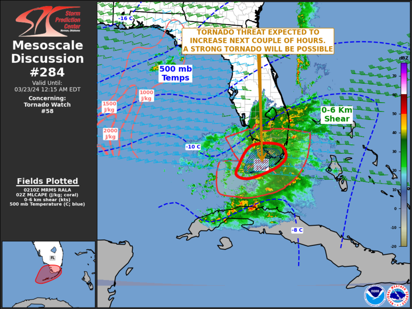
   Mesoscale Discussion 0284
   NWS Storm Prediction Center Norman OK
   0913 PM CDT Fri Mar 22 2024

   Areas affected...South Florida and the Florida Keys

   Concerning...Tornado Watch 58...

   Valid 230213Z - 230415Z

   The severe weather threat for Tornado Watch 58 continues.

   SUMMARY...A tornado threat will continue over the Florida Keys, and
   is expected to develop and increase over the southern Florida
   Peninsula over the next couple of hours.

   DISCUSSION...The latest high-resolution radar from Key West shows a
   cluster of strong to severe storms over the waters to the north of
   and just south of Key West. Well-organized and strongly rotating
   supercells appear to be ongoing within this cluster. The cluster
   will move eastward across the Florida Keys vicinity over the next
   couple of hours. Additional storms are expected to develop across
   the southern Florida Peninsula. According to the RAP, MLCAPE in the
   Florida Keys is generally near or above 1000 J/kg, with somewhat
   weaker instability in south Florida. The WSR-88D VWP at Key West
   still has an impressive shear environment, with 0-6 km shear at 60
   knots, and 0-3 storm-relative helicity near 300 m2/s2.  This should
   continue support a tornado threat with supercells, and a strong
   tornado will be possible with the any supercell that becomes
   intense. A wind-damage and isolated large hail will also likely
   accompany the stronger storms. If a line segment can become
   organized, then the wind-damage threat will likely increase as well.

   ..Broyles.. 03/23/2024

   ...Please see www.spc.noaa.gov for graphic product...

   ATTN...WFO...MFL...KEY...

   LAT...LON   24898228 24448240 24318183 24678078 25038026 25388021
               25648040 25738076 25748134 25628177 25368204 24898228
|
|
Top/All Mesoscale Discussions/Forecast Products/Home
|
|


 @NWSSPC