 Note:
The expiration time in the watch graphic is amended if the watch is
replaced, cancelled or extended.
Note:
Note:
The expiration time in the watch graphic is amended if the watch is
replaced, cancelled or extended.
Note: Click for
Watch Status Reports.
SEL1
URGENT - IMMEDIATE BROADCAST REQUESTED
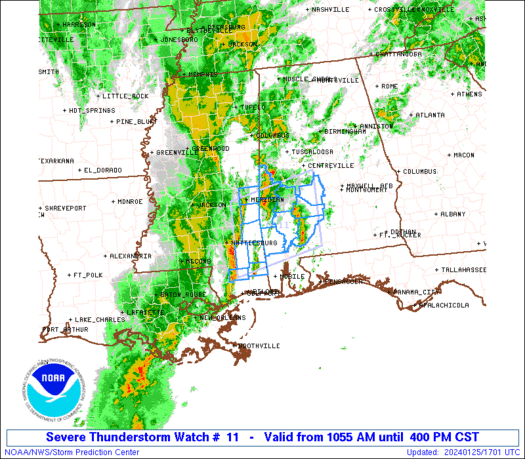
Severe Thunderstorm Watch Number 11
NWS Storm Prediction Center Norman OK
1055 AM CST Thu Jan 25 2024
The NWS Storm Prediction Center has issued a
* Severe Thunderstorm Watch for portions of
Southwest Alabama
Southeast Mississippi
* Effective this Thursday morning and afternoon from 1055 AM
until 400 PM CST.
* Primary threats include...
Scattered damaging wind gusts to 65 mph possible
A tornado or two possible
SUMMARY...A linear cluster of storms will continue generally
eastward across the region and pose a severe risk, with some
possibility that a few line-preceding storms also pose a severe risk
this afternoon.
The severe thunderstorm watch area is approximately along and 55
statute miles north and south of a line from 60 miles south
southwest of Meridian MS to 40 miles north of Evergreen AL. For a
complete depiction of the watch see the associated watch outline
update (WOUS64 KWNS WOU1).
PRECAUTIONARY/PREPAREDNESS ACTIONS...
REMEMBER...A Severe Thunderstorm Watch means conditions are
favorable for severe thunderstorms in and close to the watch area.
Persons in these areas should be on the lookout for threatening
weather conditions and listen for later statements and possible
warnings. Severe thunderstorms can and occasionally do produce
tornadoes.
&&
AVIATION...A few severe thunderstorms with hail surface and aloft to
0.5 inches. Extreme turbulence and surface wind gusts to 55 knots. A
few cumulonimbi with maximum tops to 450. Mean storm motion vector
24030.
...Guyer

   SEL1

   URGENT - IMMEDIATE BROADCAST REQUESTED
   Severe Thunderstorm Watch Number 11
   NWS Storm Prediction Center Norman OK
   1055 AM CST Thu Jan 25 2024

   The NWS Storm Prediction Center has issued a

   * Severe Thunderstorm Watch for portions of
     Southwest Alabama
     Southeast Mississippi

   * Effective this Thursday morning and afternoon from 1055 AM
     until 400 PM CST.

   * Primary threats include...
     Scattered damaging wind gusts to 65 mph possible
     A tornado or two possible

   SUMMARY...A linear cluster of storms will continue generally
   eastward across the region and pose a severe risk, with some
   possibility that a few line-preceding storms also pose a severe risk
   this afternoon.

   The severe thunderstorm watch area is approximately along and 55
   statute miles north and south of a line from 60 miles south
   southwest of Meridian MS to 40 miles north of Evergreen AL. For a
   complete depiction of the watch see the associated watch outline
   update (WOUS64 KWNS WOU1).

   PRECAUTIONARY/PREPAREDNESS ACTIONS...

   REMEMBER...A Severe Thunderstorm Watch means conditions are
   favorable for severe thunderstorms in and close to the watch area.
   Persons in these areas should be on the lookout for threatening
   weather conditions and listen for later statements and possible
   warnings. Severe thunderstorms can and occasionally do produce
   tornadoes.

   &&

   AVIATION...A few severe thunderstorms with hail surface and aloft to
   0.5 inches. Extreme turbulence and surface wind gusts to 55 knots. A
   few cumulonimbi with maximum tops to 450. Mean storm motion vector
   24030.

   ...Guyer
 Note:
The Aviation Watch (SAW) product is an approximation to the watch area.
The actual watch is depicted by the shaded areas.
Note:
The Aviation Watch (SAW) product is an approximation to the watch area.
The actual watch is depicted by the shaded areas.
   SAW1
   WW 11 SEVERE TSTM AL MS 251655Z - 252200Z
   AXIS..55 STATUTE MILES NORTH AND SOUTH OF LINE..
   60SSW MEI/MERIDIAN MS/ - 40N GZH/EVERGREEN AL/
   ..AVIATION COORDS.. 50NM N/S /54SSW MEI - 39WSW MGM/
   HAIL SURFACE AND ALOFT..0.5 INCH. WIND GUSTS..55 KNOTS.
   MAX TOPS TO 450. MEAN STORM MOTION VECTOR 24030.

   LAT...LON 32328914 32798704 31208704 30738914

   THIS IS AN APPROXIMATION TO THE WATCH AREA.  FOR A
   COMPLETE DEPICTION OF THE WATCH SEE WOUS64 KWNS
   FOR WOU1.
Watch 11 Status Report Messages:
STATUS REPORT #2 ON WW 11

VALID 251920Z - 252040Z

SEVERE WEATHER THREAT CONTINUES RIGHT OF A LINE FROM 30 NE MOB TO
45 NW GZH TO 35 SSE TCL.

..KERR..01/25/24

ATTN...WFO...MOB...BMX...JAN...

&&

STATUS REPORT FOR WS 11

SEVERE WEATHER THREAT CONTINUES FOR THE FOLLOWING AREAS

ALC047-099-131-252040-

AL
.    ALABAMA COUNTIES INCLUDED ARE

DALLAS		     MONROE		 WILCOX
$$


THE WATCH STATUS MESSAGE IS FOR GUIDANCE PURPOSES ONLY.  PLEASE
REFER TO WATCH COUNTY NOTIFICATION STATEMENTS FOR OFFICIAL
INFORMATION ON COUNTIES...INDEPENDENT CITIES AND MARINE ZONES
CLEARED FROM SEVERE THUNDERSTORM AND TORNADO WATCHES.
$$

STATUS REPORT #1 ON WW 11

VALID 251820Z - 251940Z

SEVERE WEATHER THREAT CONTINUES RIGHT OF A LINE FROM 20 NW MOB TO
55 E PIB TO 45 SSW TCL.

..KERR..01/25/24

ATTN...WFO...MOB...BMX...JAN...

&&

STATUS REPORT FOR WS 11

SEVERE WEATHER THREAT CONTINUES FOR THE FOLLOWING AREAS

ALC025-047-091-099-129-131-251940-

AL
.    ALABAMA COUNTIES INCLUDED ARE

CLARKE		     DALLAS		 MARENGO
MONROE		     WASHINGTON 	 WILCOX
$$


THE WATCH STATUS MESSAGE IS FOR GUIDANCE PURPOSES ONLY.  PLEASE
REFER TO WATCH COUNTY NOTIFICATION STATEMENTS FOR OFFICIAL
INFORMATION ON COUNTIES...INDEPENDENT CITIES AND MARINE ZONES
CLEARED FROM SEVERE THUNDERSTORM AND TORNADO WATCHES.
$$
Note:
Click for Complete Product Text.
Tornadoes
Probability of 2 or more tornadoes
|
Low (20%)
|
Probability of 1 or more strong (EF2-EF5) tornadoes
|
Low (20%)
|
Wind
Probability of 10 or more severe wind events
|
Mod (40%)
|
Probability of 1 or more wind events > 65 knots
|
Low (<5%)
|
Hail
Probability of 10 or more severe hail events
|
Low (<5%)
|
Probability of 1 or more hailstones > 2 inches
|
Low (<5%)
|
Combined Severe Hail/Wind
Probability of 6 or more combined severe hail/wind events
|
Mod (60%)
|
For each watch, probabilities for particular events inside the watch
(listed above in each table) are determined by the issuing forecaster.
The "Low" category contains probability values ranging from less than 2%
to 20% (EF2-EF5 tornadoes), less than 5% to 20% (all other probabilities),
"Moderate" from 30% to 60%, and "High" from 70% to greater than 95%.
High values are bolded and lighter in color to provide awareness of
an increased threat for a particular event.


 @NWSSPC


