Note:
The expiration time in the watch graphic is amended if the watch is
replaced, cancelled or extended.
Note:
Note:
The expiration time in the watch graphic is amended if the watch is
replaced, cancelled or extended.
Note: Click for
Watch Status Reports.
SEL0
URGENT - IMMEDIATE BROADCAST REQUESTED
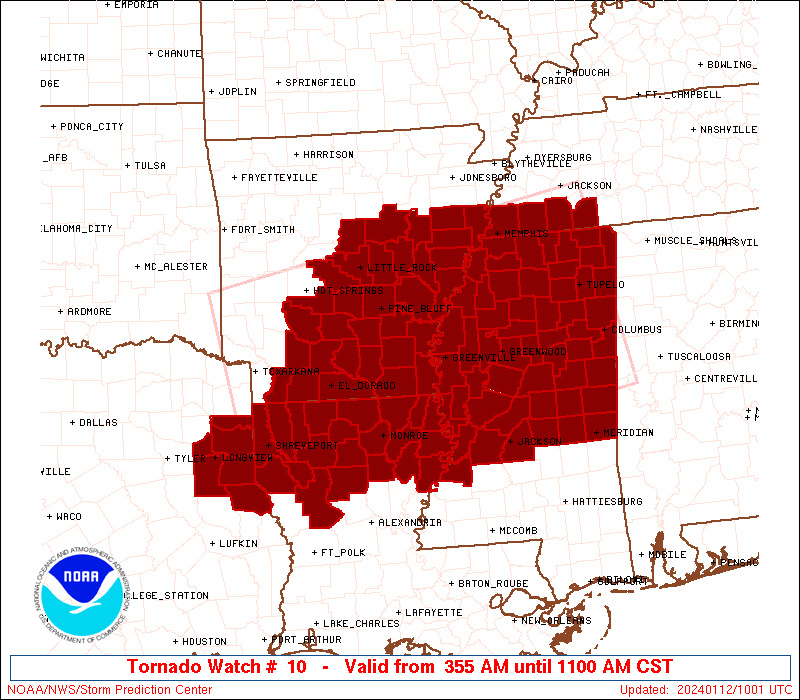
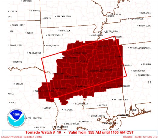
Tornado Watch Number 10
NWS Storm Prediction Center Norman OK
355 AM CST Fri Jan 12 2024
The NWS Storm Prediction Center has issued a
* Tornado Watch for portions of
Southern, central and eastern Arkansas
Northern Louisiana
Northern and central Mississippi
Southwestern Tennessee
Northeast Texas
* Effective this Friday morning from 355 AM until 1100 AM CST.
* Primary threats include...
A few tornadoes possible
Scattered damaging winds and isolated significant gusts to 80
mph likely
Isolated large hail events to 1.5 inches in diameter possible
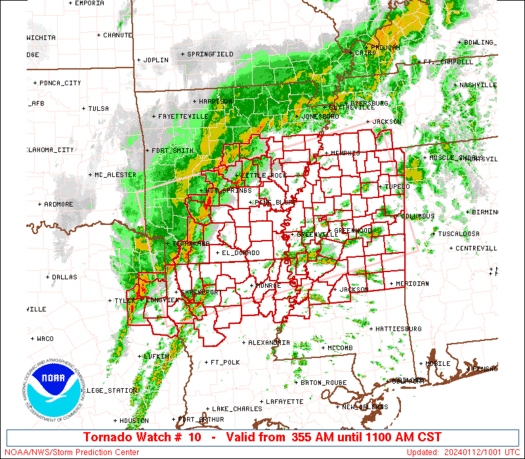
SUMMARY...A line of severe thunderstorms is expected to become
better organized the next few hours and sweep eastward across the
watch area through the remainder of the morning, offering severe
gusts (some potentially over 70 mph), a few tornadoes, and isolated
hail. Isolated severe thunderstorms also may form ahead of the
line, with all the same hazards possible.
The tornado watch area is approximately along and 95 statute miles
either side of a line from 30 miles southwest of Texarkana AR to 25
miles east of Tupelo MS. For a complete depiction of the watch see
the associated watch outline update (WOUS64 KWNS WOU0).
PRECAUTIONARY/PREPAREDNESS ACTIONS...
REMEMBER...A Tornado Watch means conditions are favorable for
tornadoes and severe thunderstorms in and close to the watch
area. Persons in these areas should be on the lookout for
threatening weather conditions and listen for later statements
and possible warnings.
&&
OTHER WATCH INFORMATION...This tornado watch replaces tornado
watch number 9. Watch number 9 will not be in effect after 355 AM
CST.
AVIATION...Tornadoes and a few severe thunderstorms with hail
surface and aloft to 1.5 inches. Extreme turbulence and surface wind
gusts to 70 knots. A few cumulonimbi with maximum tops to 450. Mean
storm motion vector 25040.
...Edwards
   SEL0

   URGENT - IMMEDIATE BROADCAST REQUESTED
   Tornado Watch Number 10
   NWS Storm Prediction Center Norman OK
   355 AM CST Fri Jan 12 2024

   The NWS Storm Prediction Center has issued a

   * Tornado Watch for portions of
     Southern, central and eastern Arkansas
     Northern Louisiana
     Northern and central Mississippi
     Southwestern Tennessee
     Northeast Texas

   * Effective this Friday morning from 355 AM until 1100 AM CST.

   * Primary threats include...
     A few tornadoes possible
     Scattered damaging winds and isolated significant gusts to 80
       mph likely
     Isolated large hail events to 1.5 inches in diameter possible

   SUMMARY...A line of severe thunderstorms is expected to become
   better organized the next few hours and sweep eastward across the
   watch area through the remainder of the morning, offering severe
   gusts (some potentially over 70 mph), a few tornadoes, and isolated
   hail.  Isolated severe thunderstorms also may form ahead of the
   line, with all the same hazards possible.

   The tornado watch area is approximately along and 95 statute miles
   either side of a line from 30 miles southwest of Texarkana AR to 25
   miles east of Tupelo MS. For a complete depiction of the watch see
   the associated watch outline update (WOUS64 KWNS WOU0).

   PRECAUTIONARY/PREPAREDNESS ACTIONS...

   REMEMBER...A Tornado Watch means conditions are favorable for
   tornadoes and severe thunderstorms in and close to the watch
   area. Persons in these areas should be on the lookout for
   threatening weather conditions and listen for later statements
   and possible warnings.

   &&

   OTHER WATCH INFORMATION...This tornado watch replaces tornado
   watch number 9. Watch number 9 will not be in effect after 355 AM
   CST.

   AVIATION...Tornadoes and a few severe thunderstorms with hail
   surface and aloft to 1.5 inches. Extreme turbulence and surface wind
   gusts to 70 knots. A few cumulonimbi with maximum tops to 450. Mean
   storm motion vector 25040.

   ...Edwards
 Note:
The Aviation Watch (SAW) product is an approximation to the watch area.
The actual watch is depicted by the shaded areas.
Note:
The Aviation Watch (SAW) product is an approximation to the watch area.
The actual watch is depicted by the shaded areas.
   SAW0
   WW 10 TORNADO AR LA MS TN TX 120955Z - 121700Z
   AXIS..95 STATUTE MILES EITHER SIDE OF LINE..
   30SW TXK/TEXARKANA AR/ - 25E TUP/TUPELO MS/
   ..AVIATION COORDS.. 80NM EITHER SIDE /27SW TXK - 48N IGB/
   HAIL SURFACE AND ALOFT..1.5 INCHES. WIND GUSTS..70 KNOTS.
   MAX TOPS TO 450. MEAN STORM MOTION VECTOR 25040.

   REPLACES WW 9..AR LA OK TX

   LAT...LON 34499466 35628863 32918804 31799408

   THIS IS AN APPROXIMATION TO THE WATCH AREA.  FOR A
   COMPLETE DEPICTION OF THE WATCH SEE WOUS64 KWNS
   FOR WOU0.
Watch 10 Status Report Messages:
STATUS REPORT #5 ON WW 10

VALID 121455Z - 121540Z

SEVERE WEATHER THREAT CONTINUES RIGHT OF A LINE FROM 20 NE HEZ TO
60 S GLH TO 40 S GWO TO 30 E GWO TO 15 ESE UOX TO 35 S MKL TO 15
NNW MKL.

FOR ADDITIONAL INFORMATION SEE MESOSCALE DISCUSSION 53

..JEWELL..01/12/24

ATTN...WFO...LZK...JAN...SHV...MEG...

&&

STATUS REPORT FOR WT 10

SEVERE WEATHER THREAT CONTINUES FOR THE FOLLOWING AREAS

MSC003-007-009-013-017-019-021-023-025-029-031-035-037-049-051-
057-061-063-065-067-069-073-075-077-079-081-085-087-089-091-095-
097-099-101-103-105-115-117-121-123-127-129-139-141-145-149-155-
159-163-121540-

MS
.    MISSISSIPPI COUNTIES INCLUDED ARE

ALCORN		     ATTALA		 BENTON
CALHOUN 	     CHICKASAW		 CHOCTAW
CLAIBORNE	     CLARKE		 CLAY
COPIAH		     COVINGTON		 FORREST
FRANKLIN	     HINDS		 HOLMES
ITAWAMBA	     JASPER		 JEFFERSON
JEFFERSON DAVIS      JONES		 KEMPER
LAMAR		     LAUDERDALE 	 LAWRENCE
LEAKE		     LEE		 LINCOLN
LOWNDES 	     MADISON		 MARION
MONROE		     MONTGOMERY 	 NESHOBA
NEWTON		     NOXUBEE		 OKTIBBEHA
PONTOTOC	     PRENTISS		 RANKIN
SCOTT		     SIMPSON		 SMITH
TIPPAH		     TISHOMINGO 	 UNION
WARREN		     WEBSTER		 WINSTON
YAZOO
$$


TNC069-109-121540-

TN
.    TENNESSEE COUNTIES INCLUDED ARE

HARDEMAN	     MCNAIRY
$$


THE WATCH STATUS MESSAGE IS FOR GUIDANCE PURPOSES ONLY.  PLEASE
REFER TO WATCH COUNTY NOTIFICATION STATEMENTS FOR OFFICIAL
INFORMATION ON COUNTIES...INDEPENDENT CITIES AND MARINE ZONES
CLEARED FROM SEVERE THUNDERSTORM AND TORNADO WATCHES.
$$

STATUS REPORT #4 ON WW 10

VALID 121450Z - 121540Z

SEVERE WEATHER THREAT CONTINUES RIGHT OF A LINE FROM 20 NE HEZ TO
60 S GLH TO 40 S GWO TO 30 E GWO TO 15 ESE UOX TO 35 S MKL TO 15
NNW MKL.

FOR ADDITIONAL INFORMATION SEE MESOSCALE DISCUSSION 53

..JEWELL..01/12/24

ATTN...WFO...LZK...JAN...SHV...MEG...

&&

STATUS REPORT FOR WT 10

SEVERE WEATHER THREAT CONTINUES FOR THE FOLLOWING AREAS

MSC003-007-009-013-017-019-021-023-025-029-031-035-037-049-051-
057-061-063-065-067-069-073-075-077-079-081-085-087-089-091-095-
097-099-101-103-105-115-117-121-123-127-129-139-141-145-149-155-
159-163-121540-

MS
.    MISSISSIPPI COUNTIES INCLUDED ARE

ALCORN		     ATTALA		 BENTON
CALHOUN 	     CHICKASAW		 CHOCTAW
CLAIBORNE	     CLARKE		 CLAY
COPIAH		     COVINGTON		 FORREST
FRANKLIN	     HINDS		 HOLMES
ITAWAMBA	     JASPER		 JEFFERSON
JEFFERSON DAVIS      JONES		 KEMPER
LAMAR		     LAUDERDALE 	 LAWRENCE
LEAKE		     LEE		 LINCOLN
LOWNDES 	     MADISON		 MARION
MONROE		     MONTGOMERY 	 NESHOBA
NEWTON		     NOXUBEE		 OKTIBBEHA
PONTOTOC	     PRENTISS		 RANKIN
SCOTT		     SIMPSON		 SMITH
TIPPAH		     TISHOMINGO 	 UNION
WARREN		     WEBSTER		 WINSTON
YAZOO
$$


TNC069-109-121540-

TN
.    TENNESSEE COUNTIES INCLUDED ARE

HARDEMAN	     MCNAIRY
$$


THE WATCH STATUS MESSAGE IS FOR GUIDANCE PURPOSES ONLY.  PLEASE
REFER TO WATCH COUNTY NOTIFICATION STATEMENTS FOR OFFICIAL
INFORMATION ON COUNTIES...INDEPENDENT CITIES AND MARINE ZONES
CLEARED FROM SEVERE THUNDERSTORM AND TORNADO WATCHES.
$$

STATUS REPORT #3 ON WW 10

VALID 121325Z - 121440Z

SEVERE WEATHER THREAT CONTINUES RIGHT OF A LINE FROM 30 N ESF TO
50 NNW GWO TO 30 E JBR.

FOR ADDITIONAL INFORMATION SEE MESOSCALE DISCUSSION 52

..DEAN..01/12/24

ATTN...WFO...LZK...JAN...SHV...MEG...

&&

STATUS REPORT FOR WT 10

SEVERE WEATHER THREAT CONTINUES FOR THE FOLLOWING AREAS

ARC017-121440-

AR
.    ARKANSAS COUNTIES INCLUDED ARE

CHICOT
$$


LAC035-041-065-083-107-123-121440-

LA
.    LOUISIANA PARISHES INCLUDED ARE

EAST CARROLL	     FRANKLIN		 MADISON
RICHLAND	     TENSAS		 WEST CARROLL
$$


MSC003-007-009-013-015-017-019-021-025-033-043-049-051-053-055-
057-069-071-075-079-081-083-087-089-093-095-097-099-101-103-105-
107-115-117-119-121-123-125-133-135-137-139-141-145-149-151-155-
159-161-163-121440-

MS
.    MISSISSIPPI COUNTIES INCLUDED ARE

ALCORN		     ATTALA		 BENTON
CALHOUN 	     CARROLL		 CHICKASAW
CHOCTAW 	     CLAIBORNE		 CLAY
DESOTO		     GRENADA		 HINDS
HOLMES		     HUMPHREYS		 ISSAQUENA
ITAWAMBA	     KEMPER		 LAFAYETTE
LAUDERDALE	     LEAKE		 LEE
LEFLORE 	     LOWNDES		 MADISON
MARSHALL	     MONROE		 MONTGOMERY
NESHOBA 	     NEWTON		 NOXUBEE
OKTIBBEHA	     PANOLA		 PONTOTOC
PRENTISS	     QUITMAN		 RANKIN
SCOTT		     SHARKEY		 SUNFLOWER
TALLAHATCHIE	     TATE		 TIPPAH
TISHOMINGO	     UNION		 WARREN
WASHINGTON	     WEBSTER		 WINSTON
YALOBUSHA	     YAZOO
$$


TNC047-069-109-157-121440-

TN
.    TENNESSEE COUNTIES INCLUDED ARE

FAYETTE 	     HARDEMAN		 MCNAIRY
SHELBY
$$


THE WATCH STATUS MESSAGE IS FOR GUIDANCE PURPOSES ONLY.  PLEASE
REFER TO WATCH COUNTY NOTIFICATION STATEMENTS FOR OFFICIAL
INFORMATION ON COUNTIES...INDEPENDENT CITIES AND MARINE ZONES
CLEARED FROM SEVERE THUNDERSTORM AND TORNADO WATCHES.
$$

STATUS REPORT #2 ON WW 10

VALID 121235Z - 121340Z

SEVERE WEATHER THREAT CONTINUES RIGHT OF A LINE FROM 20 S IER TO
40 ESE SHV TO 35 NE LLQ TO JBR.

FOR ADDITIONAL INFORMATION SEE MESOSCALE DISCUSSION 52

..DEAN..01/12/24

ATTN...WFO...LZK...JAN...SHV...MEG...

&&

STATUS REPORT FOR WT 10

SEVERE WEATHER THREAT CONTINUES FOR THE FOLLOWING AREAS

ARC003-017-035-037-077-107-123-121340-

AR
.    ARKANSAS COUNTIES INCLUDED ARE

ASHLEY		     CHICOT		 CRITTENDEN
CROSS		     LEE		 PHILLIPS
ST. FRANCIS
$$


LAC013-021-035-041-049-061-065-067-069-073-083-107-111-123-127-
121340-

LA
.    LOUISIANA PARISHES INCLUDED ARE

BIENVILLE	     CALDWELL		 EAST CARROLL
FRANKLIN	     JACKSON		 LINCOLN
MADISON 	     MOREHOUSE		 NATCHITOCHES
OUACHITA	     RICHLAND		 TENSAS
UNION		     WEST CARROLL	 WINN
$$


MSC003-007-009-011-013-015-017-019-021-025-027-033-043-049-051-
053-055-057-069-071-075-079-081-083-087-089-093-095-097-099-101-
103-105-107-115-117-119-121-123-125-133-135-137-139-141-143-145-
149-151-155-159-161-163-121340-

MS
.    MISSISSIPPI COUNTIES INCLUDED ARE

ALCORN		     ATTALA		 BENTON
BOLIVAR 	     CALHOUN		 CARROLL
CHICKASAW	     CHOCTAW		 CLAIBORNE
CLAY		     COAHOMA		 DESOTO
GRENADA 	     HINDS		 HOLMES
HUMPHREYS	     ISSAQUENA		 ITAWAMBA
KEMPER		     LAFAYETTE		 LAUDERDALE
LEAKE		     LEE		 LEFLORE
LOWNDES 	     MADISON		 MARSHALL
MONROE		     MONTGOMERY 	 NESHOBA
NEWTON		     NOXUBEE		 OKTIBBEHA
PANOLA		     PONTOTOC		 PRENTISS
QUITMAN 	     RANKIN		 SCOTT
SHARKEY 	     SUNFLOWER		 TALLAHATCHIE
TATE		     TIPPAH		 TISHOMINGO
TUNICA		     UNION		 WARREN
WASHINGTON	     WEBSTER		 WINSTON
YALOBUSHA	     YAZOO
$$


TNC047-069-109-157-121340-

TN
.    TENNESSEE COUNTIES INCLUDED ARE

FAYETTE 	     HARDEMAN		 MCNAIRY
SHELBY
$$


THE WATCH STATUS MESSAGE IS FOR GUIDANCE PURPOSES ONLY.  PLEASE
REFER TO WATCH COUNTY NOTIFICATION STATEMENTS FOR OFFICIAL
INFORMATION ON COUNTIES...INDEPENDENT CITIES AND MARINE ZONES
CLEARED FROM SEVERE THUNDERSTORM AND TORNADO WATCHES.
$$

STATUS REPORT #1 ON WW 10

VALID 121115Z - 121240Z

SEVERE WEATHER THREAT CONTINUES RIGHT OF A LINE FROM 35 NE LFK TO
15 N SHV TO 30 WSW PBF TO 15 SW BVX.

..DEAN..01/12/24

ATTN...WFO...LZK...JAN...SHV...MEG...

&&

STATUS REPORT FOR WT 10

SEVERE WEATHER THREAT CONTINUES FOR THE FOLLOWING AREAS

ARC001-003-011-013-017-025-035-037-041-043-069-077-079-085-095-
107-117-123-139-145-147-121240-

AR
.    ARKANSAS COUNTIES INCLUDED ARE

ARKANSAS	     ASHLEY		 BRADLEY
CALHOUN 	     CHICOT		 CLEVELAND
CRITTENDEN	     CROSS		 DESHA
DREW		     JEFFERSON		 LEE
LINCOLN 	     LONOKE		 MONROE
PHILLIPS	     PRAIRIE		 ST. FRANCIS
UNION		     WHITE		 WOODRUFF
$$


LAC013-015-017-021-027-031-035-041-049-061-065-067-069-073-081-
083-107-111-119-123-127-121240-

LA
.    LOUISIANA PARISHES INCLUDED ARE

BIENVILLE	     BOSSIER		 CADDO
CALDWELL	     CLAIBORNE		 DE SOTO
EAST CARROLL	     FRANKLIN		 JACKSON
LINCOLN 	     MADISON		 MOREHOUSE
NATCHITOCHES	     OUACHITA		 RED RIVER
RICHLAND	     TENSAS		 UNION
WEBSTER 	     WEST CARROLL	 WINN
$$


MSC003-007-009-011-013-015-017-019-021-025-027-033-043-049-051-
053-055-057-069-071-075-079-081-083-087-089-093-095-097-099-101-
103-105-107-115-117-119-121-123-125-133-135-137-139-141-143-145-
149-151-155-159-161-163-121240-

MS
.    MISSISSIPPI COUNTIES INCLUDED ARE

ALCORN		     ATTALA		 BENTON
BOLIVAR 	     CALHOUN		 CARROLL
CHICKASAW	     CHOCTAW		 CLAIBORNE
CLAY		     COAHOMA		 DESOTO
GRENADA 	     HINDS		 HOLMES
HUMPHREYS	     ISSAQUENA		 ITAWAMBA
KEMPER		     LAFAYETTE		 LAUDERDALE
LEAKE		     LEE		 LEFLORE
LOWNDES 	     MADISON		 MARSHALL
MONROE		     MONTGOMERY 	 NESHOBA
NEWTON		     NOXUBEE		 OKTIBBEHA
PANOLA		     PONTOTOC		 PRENTISS
QUITMAN 	     RANKIN		 SCOTT
SHARKEY 	     SUNFLOWER		 TALLAHATCHIE
TATE		     TIPPAH		 TISHOMINGO
TUNICA		     UNION		 WARREN
WASHINGTON	     WEBSTER		 WINSTON
YALOBUSHA	     YAZOO
$$


TNC047-069-109-157-121240-

TN
.    TENNESSEE COUNTIES INCLUDED ARE

FAYETTE 	     HARDEMAN		 MCNAIRY
SHELBY
$$


TXC419-121240-

TX
.    TEXAS COUNTIES INCLUDED ARE

SHELBY
$$


THE WATCH STATUS MESSAGE IS FOR GUIDANCE PURPOSES ONLY.  PLEASE
REFER TO WATCH COUNTY NOTIFICATION STATEMENTS FOR OFFICIAL
INFORMATION ON COUNTIES...INDEPENDENT CITIES AND MARINE ZONES
CLEARED FROM SEVERE THUNDERSTORM AND TORNADO WATCHES.
$$
Note:
Click for Complete Product Text.
Tornadoes
Probability of 2 or more tornadoes
|
Mod (50%)
|
Probability of 1 or more strong (EF2-EF5) tornadoes
|
Low (20%)
|
Wind
Probability of 10 or more severe wind events
|
Mod (60%)
|
Probability of 1 or more wind events > 65 knots
|
Mod (60%)
|
Hail
Probability of 10 or more severe hail events
|
Low (20%)
|
Probability of 1 or more hailstones > 2 inches
|
Low (10%)
|
Combined Severe Hail/Wind
Probability of 6 or more combined severe hail/wind events
|
High (80%)
|
For each watch, probabilities for particular events inside the watch
(listed above in each table) are determined by the issuing forecaster.
The "Low" category contains probability values ranging from less than 2%
to 20% (EF2-EF5 tornadoes), less than 5% to 20% (all other probabilities),
"Moderate" from 30% to 60%, and "High" from 70% to greater than 95%.
High values are bolded and lighter in color to provide awareness of
an increased threat for a particular event.


 @NWSSPC